Advanced satellite company DigitalGlobe sets sights on Ukraine
When Malaysia Airlines Flight 370 disappeared in March, a Colorado company allowed the world to search for clues from its satellite photos.
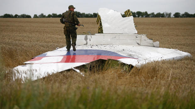
Now, that same team is working to capture images of the debris field in Ukraine following the Malaysia Airlines Flight 17 crash, CBS News correspondent Barry Petersen reports.
If you want to see the newest eye headed for the sky, it means suiting up in the clean room with Walter Scott, who founded satellite imaging company DigitalGlobe.
He has a parent's pride for his brand new half-billion dollar baby called WorldView-3.
Approximately half of the satellite consists of camera parts.
"All the way from the top to about halfway down is camera," Scott said.
The newest satellite will join the company's five other satellites already in space, and for getting there, thank Scott's persistence.
In 1992, as a computer scientist grounded with a broken foot, he founded DigitalGlobe with $3,000. A few years later they built their first satellite, Early Bird.
"The first satellite went up, then died four days later," Scott said. And as for the second try, "that went up and went down a lot faster."
Scott said what allowed him to continue after that was "boundless enthusiasm and a lack of common sense."
Good insurance and patient investors finally got the first successful satellite off the ground in 2001.
Today, from its Longmont, Colorado, headquarters, DigitalGlobe provides imagery for everyone from the government to Google.
Whether it's the pyramids, the Eiffel Tower, the Grand Canyon, the Great Barrier Reef or your backyard, it's captured more than three billion square miles of imagery.
Mining these pretty pictures for hard information is the job of Shay Har-Noy.
"We can look at strategic oil reserves by taking a satellite shot at an angle at the tanks to measure the amount of ... the floating lid tanks," Har-Noy said. "And that's very interesting."
Last March, DigitalGlobe helped search for missing Malaysia Airlines Flight 370 by letting anyone study its pictures and hunt for debris. Eight million people logged on.
Now, DigitalGlobe pictures may help in the investigation of Malaysia Flight 17 that crashed in Ukraine.
They're applying the same methodology to scenarios like tornadoes, where first responders face clogged roads and fields of debris.
"We're talking about 60-90 minutes after the imagery is collected, where we're converting it to information and an entire damage map complete with all the damaged buildings, damaged roads, damaged vegetation that we've collected," Har-Noy said.
Once WorldView-3 gets into orbit, it will go a step beyond that, like seeing what firefighters can't when forests burn.
"Pretty much every year we have a forest fire season, and with the smoke it's very hard to see the ground," Har-Noy said. "Well the shortwave infrared sees through the smoke so you can actually see what's going on the ground while the fire is still going on."
It's like CSI from space.
We won't see it, but it will watch us. And if DigitalGlobe has its way, it will make life better and sometimes safer on our world below.