Cutting-edge imaging will reveal the Chilterns’ hillforts
On 16/08/2018 At 1:48 am
Category : Missed a ThameNews story?, More News, Thame news
Responses : No Comments
THE Chilterns Conservation Board is to use cutting-edge imaging technology to produce a specialist ‘light and radar’ survey of the Chilterns as part of its ‘Beacons of the Past: Hillforts in the Chilterns Landscape’, a National Lottery-supported project.
The survey, officially known as a LiDAR survey, will enable the three-and-a-half-year project to uncover more about the Chilterns in the Iron Age, but also encourage and inspire people to find out more about and help protect the heritage environment. The survey will be carried out by Cyient Europe Ltd
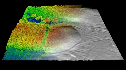
LiDAR is a type of airborne laser scanning. The innovative surveying technique will cover 1300km2 at 25cm resolution and will digitally peel back the forest canopy to reveal the hidden ancient landscapes. It is the first time the entire Chilterns AONB and environs will be subject to such a survey.
Largest survey of its kind
This summer’s weather has revealed a plethora of new archaeological sites across Britain and Ireland as dry temperatures scorch the vegetation around ancient features. But aerial photographs only show up archaeology like this if the ground is visible; woodland archaeology requires LiDAR. Flights begin in late November, to allow the best result after most leaves have fallen.
Project Manager, Dr Wendy Morrison, said: “These hillforts can’t be thought of as just being individual monuments – they didn’t exist in isolation when constructed, and they don’t now. Understanding their wider context in the landscape is crucial to understanding the roles hillforts played in society over the longue durée (Ed. their time in history). We are thrilled to be working with Cyient to discover more about the archaeology of this region,” she continued. “I believe this is the largest bespoke archaeological LiDAR survey at this resolution in the UK.”
Volunteer help
The project intends to use Citizen Science to help identify new archaeological features across the Chilterns. The processed LiDAR data will be available through an online portal in the form of images for interested volunteers to digitally annotate. Training and guidance will be provided both online and through a series of workshops held across the region over the autumn months in the run up to the survey.
Landscape Heritage Officer, Dr Ed Peveler, said: “This will be a brilliant opportunity to enrich our understanding of the history and prehistory of the Chilterns landscape. Volunteers can learn exciting new digital and practical skills, and at the same time help us to discover previously unrecorded archaeology, and to tell new stories about these hills.”
Located across four counties and only a stone’s throw from London, the Chilterns AONB is perhaps best known for is chalk streams and it leafy woodlands, but it also boasts a large number of hillforts in the UK, with 20 known monuments and potentially more which the survey may reveal. The Chilterns Conservation Board is an independent body established by Parliamentary Order in 2003 with 27 members drawn from local communities, with a statutory duty to protect, conserve and enhance the Chilterns AONB.
Advantages of airborne LiDAR surveys
Established in 1991, Cyient is a leading geospatial services provider and has a range of airborne and mobile survey products to carry out traditional aerial photography, LiDAR and oblique imagery to hyperspectral imaging and 3D modelling. “We are delighted that Chiltern Conservation Board has selected Cyient as their partner for what promises to be a very interesting project,” said Simon Kraeter, Commercial Director of Cyient. “One of the key advantages of airborne LiDAR surveys is the ability to scan a large area quickly, safely, and without the need to visit the site and potentially disturb any hidden archaeological features.”
Seeing ancient ‘lumps and bumps’ beneath the trees
Light Detection and Ranging (LiDAR) can be used to record and observe archaeology on the surface of the ground that is otherwise obscured, such as by forestation. LiDAR instruments record landscapes in three dimensions by use of a laser scanner. An airborne LiDAR system sends out small pulses of light at the rate of hundreds of thousands per second. They are reflected back from the objects they strike, and the distance is measured and recorded. When the millions of measurements are combined by computer, then a digital three-dimensional image of the landscape is formed. From this data, objects can then be digitally grouped (classified) or deleted, thus an entire forest can be removed, revealing the ground surface, and all the humps and bumps ancient people left behind.