This week from The Whitehouse blog, The Administration announces a collaboration to use high-resolution satellite imagery from DigitalGlobe to produce Digital Elevation Models of Alaska and the Arctic.
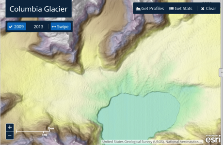
To explore the Columbia Glacier retreat for yourself, click here
This week the Administration announced that the National Geospatial-Intelligence Agency (NGA), the National Science Foundation (NSF), and the University of Minnesota’s Polar Geospatial Center (PGC), were collaborating to use high-resolution satellite imagery from DigitalGlobe, processed with NSF-supported advanced computing resources Blue Waters and the Extreme Science and Engineering Discovery Environment (XSEDE), to produce improved, publicly available Digital Elevation Models (DEMs) of Alaska by mid-2016, and of the entire Arctic by the end of next year. This effort will complement the on-going Alaska Mapping Initiative, led by the U.S. Geological Survey (USGS)’s 3D Elevation Program with support from the State of Alaska and other Federal agencies to acquire high-resolution elevation data from interferometric synthetic aperture radar (ifsar), data that will be used to update topographic mapping in Alaska.
This announcement, which directly supports President Obama’s Executive Order calling for enhanced coordination of National efforts in the Arctic, marks a significant achievement in the world of geospatial mapping.
Continue reading on the Whitehouse blog
See Also:
Users can also explore the new Arctic elevation data through online story maps developed by Esri, available here and here.