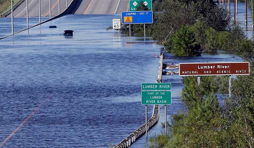
| Above: The Lumber River overflows onto a stretch Interstate 95 in Lumberton, N.C., Tuesday, Sept. 18, 2018, following flooding from Hurricane Florence. (AP Photo/Gerry Broome). |
Travel is not advised in most of southeastern and south central North Carolina due to flood waters from Hurricane Florence’s record rains, with sections of I-95 and I-40 remaining closed on Thursday, according to the state's transportation agency. Officials told drivers to avoid I-95 entirely, and instead go west into Tennessee and take I-75 through Georgia. I-40 also had severe flooding, shutting down much of the stretch between Wilmington and I-95--about 100 miles of the interstate. “At this time no safe, stable or reliable route exists for the public to get to and from Wilmington”, the agency reported.
In South Carolina, I-95 closed once again on Wednesday near the Great Pee Dee River because of flooding. It had briefly reopened Wednesday before flooding forced the new closure.
Okay so that's I-40, not a river.
— Matt Makens (@MattMakens) September 17, 2018
Video from North Carolina Aviation released by North Carolina Department of transportation. #Florence pic.twitter.com/67RZ2YRI2s
Florence’s death toll now stands at 37, and could rise further, thanks to record flooding that will continue for another week in many regions. Fourteen river gages in North Carolina and South Carolina remained in major flood on Thursday morning. Flood levels had peaked or were very close to peak at 11 of those 14 gages, but waters were still rising at the Cape Fear River and Lumber River in North Carolina and at the Waccamaw River in South Carolina, with crests expected to come early next week.
 |
| Figure 1. Observed and predicted water levels for the Cape Fear River in North Carolina, which just surpassed its all-time record water level set on September 23, 1945. The river is not expected to crest until Sunday. Image credit: NOAA/AHPS. |
Jon Erdman of weather.com has an excellent article comparing Hurricane Harvey’s rainfall with Hurricane Florence’s. Simply put, Harvey was in a different league, dumping more than three times as much rain as Florence did. Extreme rainfall tends to not be as heavy in southern North Carolina as in southeast Texas, though, so when the events are put in terms of recurrence intervals (return periods)—the amount of time one might expect between events of this magnitude—it's clear that both Harvey and Florence produced extreme rainfall for their respective locations, even though Harvey gets the nod for sheer amount of water falling from the sky.
 |
| Figure 2. Even though Harvey produced more than three times as much rain as Florence, both hurricanes produced more than a 1-in-1000-year rainfall event across large areas, as shown in the 7-day return period (or recurrence interval) maps above, based on precipitation estimates from NWS/AHPS/RFC. Image credit: Shane Hubbard, CIMSS/SSEC/UW-Madison. |
A portion of Florence’s remains could develop next week
The remnants of Florence moved off the Northeast U.S. coast on Tuesday as an elongated zone of low pressure. As least two low pressure systems are expected to develop from Florence’s remnants, with one portion potentially transitioning to a tropical or subtropical storm by the middle of next week.
The Thursday morning runs of our top three models for predicting tropical cyclone genesis—the European, GFS, and UKMET models--predicted that one portion of Florence's remnants would feed a non-tropical surface low pressure system expected to close off on Saturday in the Central Atlantic near 35°N, 45°W, between Bermuda and the Azores Islands. SSTs are unusually warm in this region, about 25 - 26°C (77 -79°F), which is more than 1°C above average. The low will get cut off from the jet stream and meander in an area of weak steering currents for many days. If the system works its way to the southeast, as recent model runs have suggested, it will find warmer ocean temperatures and moderate wind shear, which may allow a zombie Florence to rise again. It is unclear, though, if this system were to become a named storm whether or not it would retain the name Florence, since NHC has not been referring to the system as being Florence’s remains in their Tropical Weather Outlooks. In their 2 pm EDT Thursday Tropical Weather Outlook, NHC gave this system 2-day and 5-day odds of development of 0% and 50%, respectively.
The remnants of #Florence may be in the process of regenerating into a tropical cyclone east of #Bermuda.
— Philippe Papin (@pppapin) September 20, 2018
A partially exposed closed circulation now appears evident on the west side of a CDO that developed overnight. This convection appears sufficiently organized. pic.twitter.com/gzBFsUcAlx
Another portion of Florence’s remnants has formed a non-tropical low pressure system that was located a few hundred miles north of Bermuda on Thursday afternoon. While satellite loops showed this system was beginning to grow more organized (see tweet above), high wind shear should keep any development slow. There is support for development from some of the ensemble members of the GFS and European models. The low is expected to move to the southwest of Bermuda by early next week, and could loop back to the northwest and bring rain to the Southeast U.S. by Tuesday, including a half inch or more possible near the North Carolina coast. In their 2 pm EDT Thursday Tropical Weather Outlook, NHC gave this system 2-day and 5-day odds of development of 10% and 20%, respectively.
Meanwhile, yet another piece of Florence's remnants is being whisked across the North Atlantic and will bring heavy rain to the British Isles this weekend and northern Europe next week.
97L approaching Lesser Antilles: 10% chance of development
A tropical wave located about 800 miles east of the Lesser Antilles Islands on Thursday morning was designated as Invest 97L by NHC on Wednesday afternoon. Satellite imagery on Thursday morning showed 97L had become more organized since Wednesday, with a moderate amount of spin and heavy thunderstorm activity. However, the disturbance was embedded in a large area of dry air, and this dry air was limiting development. The 2 pm EDT Thursday SHIPS model showed dry air and wind shear increasing for 97L over the next two days, and the system has little model support for development. In their 2 pm EDT Thursday Tropical Weather Outlook, NHC gave this system 2-day and 5-day odds of development of 10%.
Watch the next tropical wave coming off of Africa
The 0Z and 12Z Thursday runs of the UKMET model, as well as 20 – 30% of the ensemble members of the 0Z Thursday GFS and European models, predicted that a tropical wave expected to emerge from the coast of Africa on Friday or Saturday could develop late next week as it approaches the Lesser Antilles Islands. In their 2 pm EDT Thursday Tropical Weather Outlook, NHC gave this system 2-day and 5-day odds of development of 0% and 20%, respectively.
Visible satellite animation of a developing deep cyclone in the Tyrrhenian sea this morning. A lot of deep convection is visible ongoing around the center low. This activity is expected to continue through the day and lead into and a development of a Medicane @SAT24_WEATHER pic.twitter.com/Gf3zFHFp02
— severe-weather.EU (@severeweatherEU) September 20, 2018
A Medicane developing off the west coast of Italy
An impressive tropical-cyclone-like system called a “Medicane” is developing in the Mediterranean Sea off the west coast of Italy. Medicanes are not considered to be full-fledged tropical systems, and the World Meteorological Organization has not assigned any weather agency with tracking them or giving them names. However, a Medicane can bear many of the hallmarks of a tropical storm, including a warm core, a distinct eye, and spiral banding.
SSTs across the Mediterranean are extremely warm for this (or any) time of year, largely due to the very hot summer that plagued Europe—their hottest summer in records going back to 1880. Much of the Mediterranean is running 1.5°C to 2.5°C (2.7 - 4.5°F) warmer than average, resulting in SSTs high enough to support tropical cyclone development. The “Medicane” is developing in the Tyrrhenian Sea, between the island of Sardinia and southern Italy. SSTs in this region are around 25 – 26.5°C (77 – 80°F), near the minimum threshold for tropical development. According to model runs posted at Severe Weather Europe, the Medicane could generate rainfall totals of up to 150 mm (6”) in eastern Sardinia and 100 mm (4”) in Sicily and Tunisia over the next several days, posing a flash flood risk. The emerging Medicane is expected to track southward towards Africa, moving over Tunisia over the weekend.
Bob Henson contributed to this post.


