NASA sees 'hot towers' in intensifying Typhoon Bopha

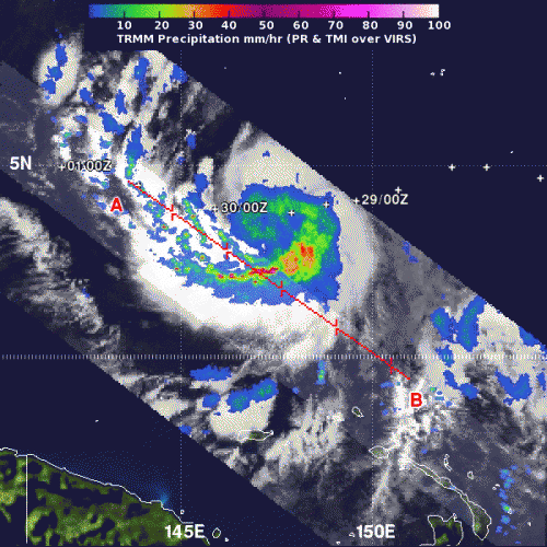
Bopha intensified into a typhoon today, Nov. 30, as it continues to affect the islands in Micronesia in the western North Pacific Ocean. NASA's TRMM satellite captured rainfall data of Bopha and noticed "Hot Tower" thunderstorms as it was intensifying from a tropical storm into a typhoon.
When NASA and the Japanese Space Agency's Tropical Rainfall Measuring Mission (TRMM) satellite passed over Bopha twice on Nov. 29, and the later data showed that the area of heaviest rainfall had expanded and was still south of the center of circulation. The heaviest rainfall was occurring at a rate of 2 inches/50 millimeters per hour.
TRMM data also showed several "hot towers" within Tropical Storm Bopha. A "hot tower" is a tall cumulonimbus cloud that reaches at least to the top of the troposphere, the lowest layer of the atmosphere. It extends approximately nine miles (14.5 km) high in the tropics. The hot towers in Bopha were over 9.3 miles (15 km) high. These towers are called "hot" because they rise to such altitude due to the large amount of latent heat. Water vapor releases this latent heat as it condenses into liquid. NASA research shows that a tropical cyclone with a hot tower in its eyewall was twice as likely to intensify within six or more hours, than a cyclone that lacked a hot tower. It was after TRMM spotted the hot towers in Bopha that the storm intensified into a typhoon.
On Nov. 30 at 10 a.m. EST (1500 UTC/1 a.m. CHST local time on Dec. 1), the National Weather Service in Guam urged residents in Koror, Kayangel and Sonsorol in the Republic of Palau and Yap Island and Ngulu Atoll in Yap State to prepare for typhoon conditions. A typhoon watch remains in effect for Ngulu in Yap State and Koror and Kayangel in the Republic of Palau. A tropical storm watch remains in effect for Yap Island in Yap State and Sonsorol in the Republic of Palau.
At 1 a.m. CHST local time on Dec. 1, (1500 UTC/10 a.m. EST, U.S. on Nov. 30) the center of Typhoon Bopha was located near latitude 4.4 degrees north and longitude 143.8 degrees east. Bopha's center was about 510 miles east-southeast of Ngulu, about 525 miles southeast of Yap, and 675 miles east-southeast of Koror Palau and Kayangel. Bopha's maximum sustained winds remain at 75 mph (120.7 kph) and the storm is expected to slowly intensify over the next day. Typhoon Bopha is moving west-northwestward at 12 mph and little change is expected in this movement through Saturday, Dec. 1.
According to the National Weather Service in Guam, "Typhoon force winds extend outward up to 20 miles from the center and tropical storm force winds extend outward up to 85 miles from the center."
Typhoon Bopha is expected to continue moving toward west-northwest. The National Weather Service official forecast track takes Bopha south of Ngulu and very close to the islands of Koror and Kayangel in the Republic of Palau. As Bopha draws closer and intensifies, winds could reach typhoon intensity (as high as 74 mph/ 64 knots/119 km/h). Surf will be very rough and rainfall can reach up to 4 inches on Saturday and up to an additional 6 inches on Sunday/Monday. Residents can expect local flooding and mudslides. The most recent National Weather Service updates can be found here: http://www.prh.noaa.gov/koror/kororCyclone.php.
Forecasters at the Joint Typhoon Warning Center forecast Bopha's center to pass close to Palau on its way to the Visayas region of Philippines by Dec. 4. Residents in the Philippines need to prepare for heavy rains, rough surf and strong winds.
Provided by NASA's Goddard Space Flight Center


