
{Originally posted to the Elder of Ziyon website}

From The New Yorker:
One afternoon in the spring of 2015, a senior State Department official named Frank Lowenstein paged through a government briefing book and noticed a map that he had never seen before. Lowenstein was the Obama Administration’s special envoy on Israeli-Palestinian negotiations, a position that exposed him to hundreds of maps of the West Bank. (One adorned his State Department office.)
Typically, those maps made Jewish settlements and outposts look tiny compared to the areas where the Palestinians lived. The new map in the briefing book was different. It showed large swaths of territory that were off limits to Palestinian development and filled in space between the settlements and the outposts. At that moment, Lowenstein told me, he saw “the forest for the trees”—not only were Palestinian population centers cut off from one another but there was virtually no way to squeeze a viable Palestinian state into the areas that remained. Lowenstein’s team did the math. When the settlement zones, the illegal outposts, and the other areas off limits to Palestinian development were consolidated, they covered almost sixty per cent of the West Bank.
Lowenstein showed the small map to Secretary of State John Kerry and said, “Look what’s really going on here.” Kerry brought the map to his next meeting with President Obama. The map was too small for everyone in the Situation Room to see, so Lowenstein had a series of larger maps made. The information was then verified by U.S. intelligence agencies. Obama’s Presidency was winding down, but Lowenstein figured that he could use the time left to raise awareness about what the Israelis were doing. “One day, everyone’s going to wake up and go, ‘Wait a minute, we’ve got to stop this to at least have the possibility of a two-state solution,’ ” Lowenstein said.
This is idiotic.
The white areas of the map are essentially Areas A and B under the Oslo Accords from 1995. Under the accords, the rest of the West Bank was under Israeli control.
This has nothing to do with settlements. It is a map of Palestinian areas being misrepresented as evidence of Israeli settlement growth.
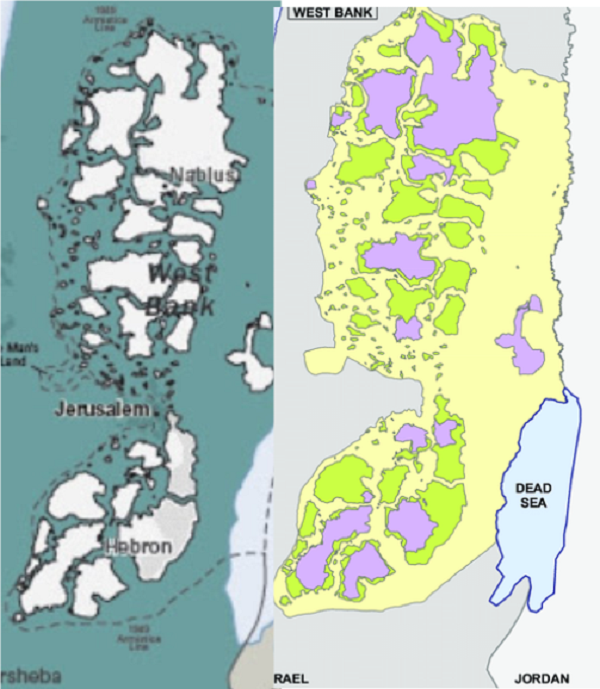
Here you can see, side by side, the State Department map of 2016 that claims that the map proves no two state solution is viable and the actual 1995 Oslo II map of Areas A and B. Pretty much identical.
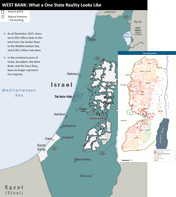
Here’s another view putting the two maps side by side, with the right hand map from ResearchGate showing Areas A and B:
If you can tell the difference between Area C in 1995 and in 2016, you have much better eyes than I do.
The Obama map is a lie.
But look how impressed the Obama White House and John Kerry was with the deception:
Kerry met regularly with Obama in the Oval Office. During one of those meetings, Kerry placed the maps on a large coffee table, one after another, so Obama and his advisers could study them. Ben Rhodes, one of Obama’s longest-serving advisers, said the President was shocked to see how “systematic” the Israelis had been at cutting off Palestinian population centers from one another. Lowenstein didn’t show the maps to the Israelis, but he did walk them through the key findings, which were incorporated into Kerry speeches and other documents.
The Israeli peace offers made after the Oslo map was created removed most of the separations between Palestinian areas.
The idea that the maps prove that Israel is gobbling land and making peace impossible is a pure falsehood.
The next paragraph shows that Mahmoud Abbas knows that the maps were wrong, even though the writer doesn’t get it:
Later, Kerry presented some of the maps to Mahmoud Abbas, the Palestinian President. Kerry’s goal was to show Abbas that the Obama Administration understood the extent to which the two-state solution was threatened. Abbas was taken aback. Instead of feeling reassured, he told a confidant that the maps convinced him that the Americans believed “the chances of a viable Palestinian state is next to nil.”
Abbas was upset because he saw how the State Department completely misinterpreted the map! He knows that in terms of square kilometers, the amount of space taken up by settlements and Israeli control is virtually identical to the amount of space agreed upon during Oslo. It doesn’t preclude peace at all – Palestinian refusal to accept the Israeli offers in 2000 and 2001 and 2008 is what precluded peace.
Finally, the deceptive maps were behind the final disgusting anti-Israel action done by Obama:
Alarmed by Israeli actions depicted in the maps, Obama decided to abstain on a U.N. Security Council resolution condemning the settlements, clearing the way for its passage.
A map that Bill Clinton would have easily recognized as being essentially a map from Oslo was wrongly interpreted by Barack Obama to be evidence of Israeli land grabs.
This story, rather than illustrating Israeli expansionism, perfectly illustrates the antipathy towards Israel shown by Kerry and Obama and their staffs.
(h/t Andrew, Avi)
[I’m not getting into the incorrect population figures on the map.]