
Large hailstorm batters Rapid City, South Dakota
Raw video: Hail pours down outside an auto shop amid a severe thunderstorm warning in Rapid City, South Dakota.
Get all the latest news on coronavirus and more delivered daily to your inbox. Sign up here.
A powerful series of thunderstorms on Sunday in South Dakota left behind a wintery scene, blanketing areas with large hail that covered roads.
The National Weather Service (NWS) office in Rapid City said that scattered severe thunderstorms in the region on Sunday brought hail to parts of the Black Hills in South Dakota, the western South Dakota Plains, and northeastern Wyoming.
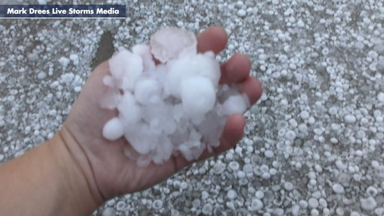
"The largest hail reported occurred in Jackson County between Potato Creek and Wanblee, where tennis ball- to baseball-sized hail was reported," forecasters said.
'GARGANTUAN' HAIL FROM THUNDERSTORM IN ARGENTINA MAY HAVE SHATTERED WORLD RECORD
A severe thunderstorm warning was issued for the Rapid City area, where videos showed hailstones pouring down.
At Sargent Garage, a Rapid City auto-shop, hail hammered vehicles parked outside in a video posted to Instagram.

A large hailstorm battered Rapid City, South Dakota, on Sunday as a severe thunderstorm impacted the area. (Sargent Garage via Storyful)
“That thunder scared the crap out of me,” the uploader wrote in a post on Instagram.
The NWS said that hail larger than 1 inch in diameter and wind gusts of up to 58 miles per hour were reported in multiple locations.

Severe thunderstorms brought large hail to western South Dakota and into Wyoming on Sunday. (NWS)
The largest hail from Sunday's storm was about 5 miles north-northeast of Potato Creek, where it measured 2.75-inches in diameter.
TORNADO SEASON DEADLIEST SINCE 2011 AFTER SEVERE WEATHER OUTBREAK IN TENNESSEE, SOUTH
"Accumulating hail was also observed in the Black Hills foothills and western Plains as several inches of hail covered the ground and roads from Black Hawk southward to northern portions of Rapid City and points southeast," the NWS said in an overview of the storms.
According to the National Oceanic and Atmospheric Administration's (NOAA) National Severe Storms Laboratory (NSSL), hail is a form of precipitation that forms inside the updrafts of thunderstorms.
Severe storm drops large hail in Texas
Raw video: North Texas pelted with large hail as a severe storm moved through the area.
"Hailstones are formed when raindrops are carried upward by thunderstorm updrafts into extremely cold areas of the atmosphere and freeze," according to the NSSL. "Hailstones then grow by colliding with liquid water drops that freeze onto the hailstone’s surface."
Hail falls when the thunderstorm's updraft can no longer support the weight of the newly formed hailstone. When those stones fall at speeds up to 100 mph, they can damage aircraft, homes, and cars, and also be deadly to livestock and people.
CLICK HERE FOR MORE WEATHER COVERAGE FROM FOX NEWS
The current world record for a hailstone is 8 inches across, or about the size of a volleyball. It fell near Vivian, S.D., on July 23, 2010.
CLICK HERE FOR THE FOX NEWS APP
NOAA's National Climate Extremes Committee said in 2010 that it also was the heaviest ever recorded in the U.S., weighing 1 pound, 15 ounces.

The hottest stories ripped from the headlines, from crime to courts, legal and scandal.
