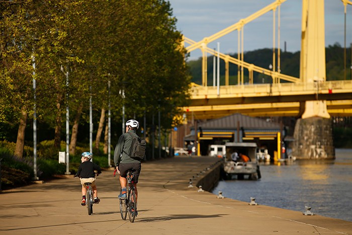
CP Photo: Jared Wickerham
Cyclists riding on the Three Rivers Heritage Trail on Pittsburgh's North Side.
But not only was riding an e-scooter in the tunnel illegal, it was exceedingly dangerous, as Pittsburgher’s e-scooters can only travel up to 15 mph, drivers in the tunnels (and just about everywhere) lack patience, and there was no shoulder for a scooter rider to pull off safety.
This is probably one of the most extreme examples in recent memory of a scooter or bike rider taking a dangerous route around Pittsburgh, but there are plenty of routes that riders take everyday that are a lot less dangerous than the Liberty Tunnel, but they still should be avoided.
Riding in Pittsburgh, like driving, is figuring out the best routes and sticking to them. Not much of the city is a grid, so alternative routes are rare. It really is best to find the safest bike and scooter routes, and stay with them.
Advocacy group Bike Pittsburgh has many great resources on this topic — including a new guide focused on safe routes to schools for parents and children looking for an alternative method of getting to class during the ongoing bus driver shortage. Bike Pittsburgh also highlights the bike infrastructure throughout the city in their bike map, which also includes cautionary bike routes that are honestly best avoided when riding bikes or scooters.
These include Penn Avenue through Lawrenceville, Bloomfield, and Garfield; Fifth and Forbes avenues through Oakland and Uptown; West Carson Street from the South Side to McKees Rocks; Irvine Street/Second Avenue in Hazelwood; West Liberty and Pioneer avenues in Brookline; Greenfield Avenue in Greenfield; and South Braddock Avenue in Regent Square.
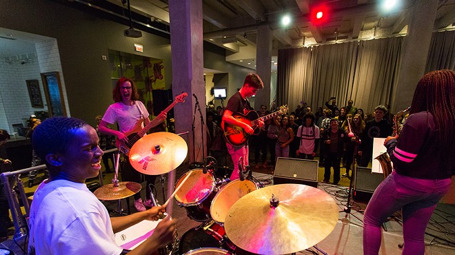
Pittsburgh is far from a mecca for cyclists, but things are getting better, and there are many relatively safe (if imperfect) routes for cyclists. Pittsburgh City Paper has broken down the safest bike and scooter routes in the city, by region.
Downtown, Strip District, and the Hill:
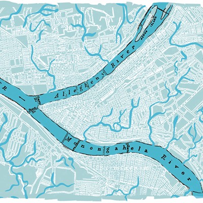
Pittsburgh’s largest central business district is fairly safe for bikes on most streets. The density and narrowness of most streets means drivers don’t speed too much and are forced to be relatively attentive. However, as a cyclist myself, I try to avoid riding on Liberty Avenue traveling east and west, and Grant Street if riding north and south. Liberty is wide by Downtown standards, but there are no bike lanes. And although it’s not usually filled with cars, it does carry a lot of buses, and it’s open enough that drivers who do drive there tend to speed. Grant Street is usually very congested during rush hour, and the brick street is less than ideal for two wheels.The protected bike lane on Penn Avenue is the safest route in Downtown. It stretches from Point State Park all the way to 16th Street in the Strip District, and runs east-west, and parallel to the Allegheny River.

If you need to ride east-west, but parallel to the Monongahela River, take Third Avenue, which has a counter-flow bike lane, and connects to a protected bike lane on Stanwix that connects to the Penn Avenue protected bike lane.
If traveling north-south through Downtown, Smithfield Street and Wood Street are the best options. Both have bus-only lanes that allow cyclists, so they are usually clear of vehicles, just the occasional bus. Wood Street's bus-bike lane travels north, with Smithfield’s travels south. Additionally, Smithfield’s northbound lane is fairly wide, and has plenty of room for cyclists to ride beside cars.
If taking the Penn Avenue protected bike lane to the Strip heading east, continuing on from there can be a bit tricky. Bikers and scooter riders can enter Spring Way alley a block up from Penn Avenue when the protected bike lane ends at 16th Street. This route is almost always void of cars, but can be slow because stops are required at every intersection, and the alley tends to be filled with debris and broken glass.
Another option is to exit the protected bike lane at 14th or 15th streets, then ride on Smallman Street on bike lanes past the Terminal development. At 21st Street, head one block toward the Allegheny River (away from the church) and get on to Railroad Street. This is the least congested and safest street to travel through the Strip District.
Once you hit 31st Street, Railroad Street ends. (There is also currently some construction along Railroad Street, so riders might have to ride up to Smallman at 28th Street.) Ride one block north to Smallman to continue east. Stay on that to get to Lawrenceville. To get to the Liberty Street bike lanes and up the hill to Bloomfield and the rest of the East End, I stay on Smallman until 33rd Street, ride up the short street past Penn Avenue, then ride up the hilly parking lot next to the Family Dollar. Then, I turn up Liberty Avenue onto the bike lanes, which start after the Herron Avenue intersection.
The Hill District is quite literally a steep hill, and not the easiest neighborhood to bike to or through, unless riding an e-bike. There is also little-to-no bike infrastructure. If you are on bike or scooter while in the Hill, Wylie Avenue is the best route to traverse the neighborhood, and riders should avoid Centre Avenue, which is highly trafficked and hilly.
North:
Heading or coming from the North Side to Downtown? The best bridges to cross are the Roberto Clemente Bridge (Sixth Street), which has protected bike lanes, and the Fort Duquesne Bridge, which has a shared-use trail for cyclists and pedestrians.From the Roberto Clemente Bridge, it's best to stay on Federal Street if wanting to ride deeper into the North Side. There is a small gap in bike infrastructure on Federal near the underpass, but cross underneath it and then there’s a protected bike lane that circles Allegheny Center on Commons. That joins another bike lane on Federal Street to the north of Allegheny Center, and into the heart of the Mexican War Streets. (There is currently construction on Federal Street between North Commons and West North Avenue. Until the construction clears, instead of taking a right onto Federal Street, stay on Commons and take a right when you hit Ridge Avenue, then take another right onto Arch Street where you'll pass the front of the National Aviary, and follow the winding road until it connects you back to West North Avenue.)
From the Fort Duquesne Bridge, follow Tony Dorsett Drive past the Clark Building and under the rail bridge. This section doesn’t have bike lanes, but it's the least congested. (Tony Dorsett Drive is currently closed to vehicular traffic due to construction, but it's still open to pedestrians. We advise cyclists use it with caution, as the top of the road can be confusing because of the construction.) When reaching Ridge Avenue, there is a network of bike lanes that move north on Ohio Street and even a new parking protected lane on Brighton Road. If traveling into California-Kirkbride and Brighton Heights, it's best to stay on Brighton Road, even though there is a gap in bike infrastructure for a few blocks.
The corridor to avoid in the North Side is the Rachel Carson Bridge and Anderson Street coming from Downtown. Cedar Avenue does have bike lanes, but they aren’t connected to much. Also, if traveling east-west through the neighborhood, avoid riding on North Avenue, and just ride on one of the trails in Allegheny Commons Park that run parallel to North Avenue instead.
If waiting to ride to Chateau or up the Allegheny River on the North Side, avoid all city streets and take the Three Rivers Heritage trail instead, which hugs both rivers.
South:
If traveling to or in the South Side, it's best to avoid Carson Street, the neighborhood’s main thoroughfare. However, there are great alternative options to reach the South Side and traverse the neighborhood.From Downtown, take the shared-use sidewalk trail across the Smithfield Street Bridge. Once at the corner of Smithfield and Carson Street, ride down onto East Station Square Drive, which resembles a parking lot road (it mostly is). From there, ride through the parking lot and get onto McKean Road just past the gas station. This is the start of the designated bike route through the South Side. Follow McKean past the Highline Building where it joins with Bingham Street.
At that intersection, riders can either head toward the Mon River on South Fourth Street and hit the trail that runs along the river all the way until the Hot Metal Bridge, or they can continue on Bingham Street past 10th Street and ride into South Side’s Neighborway.
If wanting access to the many Carson Street cafes, bars, and shops, taking the neighborway is preferred. This slow street is designed to be as safe and convenient as possible for cyclists and alternative road users, and includes infrastructure that slows down drivers to traverse through residential corridors, instead of commercial ones.
However, the neighborway isn’t a straight shot through the neighborhood, so knowing the route beforehand is helpful. There are road signs letting you know the route and where to turn, but in case you miss them, the route starts at South 10th and Bingham streets, cuts down South 11th Street to Muriel Street. Take Muriel until it ends at South 17th Street and turn towards the river, and then quickly enter Wharton Street from 17th. Then take Wharton all the way under the Birmingham Bridge (there is a new ramp under the bridge built specifically with cyclists in mind).

After crossing under the bridge, turn onto South 23rd Street, heading away from the river and turn onto Sidney Street. Take Sidney down to South 26th Street and head toward the river. From there, riders can pop on the Three Rivers Heritage Trail or take South Water Street over to the Hot Metal Bridge. And that’s traversing the South Side.
Other southern Pittsburgh neighborhoods are not as bike or scooter friendly. For one, they are extremely hilly, and there are no roads that have safe bike infrastructure. If you happen to be riding in Brookline, avoid West Liberty and Pioneer avenues, they are extremely dangerous. Also avoid Becks Run Road in Carrick and Hays.
Beechview might have the best (but not ideal) bike route on Broadway Avenue, since it is fairly wide, not that congested, and drivers should be able to pass you safely. But riders might have to deal with light-rail cars every now and again.
East:
I have seen many cyclists, particularly on weekends, riding on Penn Avenue in Bloomfield, Lawrenceville, and Garfield, and I always sigh at the sight. Penn Avenue is narrow, but drivers still regularly speed, and use it as a main thoroughfare of the East End. It's not a great road to bike on.Many new cyclists might not know about the far superior option to Penn Avenue: the Bloomfield-Friendship Neighborway. Located less than 100 yards from Penn Avenue and running parallel to the popular street, this neighborway running on Coral Street and Comrie Way was recently installed with mini roundabouts to slow drivers down and make intersections safer for cyclists and pedestrians.
It is currently the best way to bike from East Liberty to Bloomfield and eventually to Lawrenceville. It starts at Coral Street and Negley Avenue in Friendship and connects to the bike lanes on Negley Avenue. It follows Coral until that street ends, and then continues onto Comrie Way alley, which eventually ends at Main Street and Woolslayer Way.
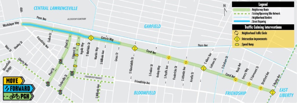
From there, if riders want to get down the hill to Lawrenceville, take Main Street instead of 40th Street. If coming back up the hill from Lawrenceville to Bloomfield, take 40th because it has a bike lane on the climbing side of the road.
Lawrenceville is a lot like the South Side, in that cyclists should avoid the main thoroughfare of Butler Street. Instead, there is a neighborway through the residential area. Thanks to a new ramp and paved surface, it starts at 51st Street right next to Spirit (which has many bike racks). Take the paved connector to Hatfield Street and ride down that until 44th Street. Turn up 44th towards Butler, and then quickly turn onto Willow Street.
Follow Willow until 40th, where you can ride up towards Butler and get on the bridge to Millvale (and the bike trail on the other side of the Allegheny River), or ride on 40th towards the river, and enter a little connector into the large parking lot of the Scoot Electrical facility. Ride through the parking lots for a few blocks until 36th Street, and then ride up 36th Street away from the river until Smallman. Then, you can ride on Smallman into the Strip District.

Getting around East Liberty, it’s also best to avoid the main thoroughfares of Penn Avenue, Baum Boulevard, and Centre Avenue. Really, avoid Baum and Penn at all costs. If you have to ride on Centre, it’s safer, but not safe. It may be longer, but riding on East Liberty Boulevard around the core of the neighborhood is safest.
And, East Liberty Boulevard bike lanes connect to Negley Avenue bike lanes, the North Euclid neighborway (into Highland Park), Negley Run protected bike lanes (down to the circle bike track on Washington Boulevard), the Broad Street bike lanes (which leads to the Target and the heart of East Liberty), and Frankstown Avenue (which is the best street to ride into Homewood).
There are no current bike lanes in Homewood, but I prefer the Frankstown to Bennett Street route, as it contains some infrastructure to help drivers slow down, and is not usually congested.
Traversing Shadyside is similar to Homewood in that the neighborhood has no bike lanes. City leaders are currently working on plans to change that, but, for now, the safest (but not really safe) route is Ellsworth Avenue. It’s not ideal, but riders should avoid Centre and Fifth avenues at all costs.
For Oakland, avoid most of Fifth and Forbes avenues south of Bigelow Boulevard. If you want to travel from Oakland to Downtown, its safest and most enjoyable to take the Junction Hollow Trail, which runs through Four Mile Run in Greenfield and eventually connects the Jail Trail which goes all the way Downtown, car-free. To enter the trail, ride down Boundary Street (which has speed humps to slow down cars) or Joncaire Street. On Joncaire, bike riders should probably take the sidewalk, (which is allowed in non-business districts) since the road is cobblestone and bumpy. E-scooters are not allowed on the sidewalks. Then, follow Boundary Street to the marked trail.
Getting through Oakland is safest on the Bayard Street bike lanes and the Forbes Avenue bike lanes, which are connected with bike lanes on Bigelow Boulevard. Forbes bike lanes run from the main branch library, past the Carnegie Mellon campus, and into Squirrel Hill.
Stay on Forbes to get into the heart of Squirrel Hill. The bike lane ends at Murdoch Street, but Forbes is still the best route into Squirrel Hill's business district. When traveling north-south in Squirrel Hill, Beechwood Boulevard has bike lanes and is safest, even if a bit meandering. It also connects all the way to Mellon Park, at the edge of Shadyside. Beechwood also connects to bike lanes on Wilkins and Dallas avenues, and leads riders into Point Breeze.
Other roads in the East End to avoid include Second Avenue/Irvine Street in Hazelwood (enter Hazelwood Green at Hazelwood Avenue and take the trails and bike lanes there to connect to the Jail Trail) and South Braddock Avenue in Regent Square (if your bike can handle a dirt and gravel trail, try to enter Frick Park and ride the Tranquil Trail up to Point Breeze instead).
West:
The city’s West End is like the wild west in terms of safe and comfortable bike routes. There really aren’t any safe routes, and the hilly terrain makes it even harder to ride. If you are riding in the West End, Bike Pittsburgh identifies Corliss Street, sections of Noblestown Road, and West Carson Street as cautionary bike routes.However, I have successfully ridden from Downtown to West End Village several times and you can too, but it is not for the faint of heart. Do not attempt this if you are not a very confident bike rider. Don’t do this on a e-scooter, partially out of safety and partially because this route contains sidewalk riding, which is illegal for scooters.
The best way to get to West End Village is to get onto the South Side trail at Station Square after crossing the shared pedestrian-bike path on the Smithfield Street Bridge (or take the trail from the South Side). Once on the trail, which can be accessed by traveling towards the river from East Station Square Drive, ride it until its end at West Carson Street, just past the Duquesne Incline. At West Carson Street, it's safest to ride on the sidewalk towards the West End Bridge.
After passing the Pacific Pride commercial fueling station, it actually gets fairly dangerous. After waiting for traffic to clear, get onto West Carson and ride up the ramp to the West End Bridge (you can also stay on the sidewalk on West Carson and then carry your bike up the stairs at the bridge). Once you arrive to the intersection of the ramp and South Main Street, follow the keyboard crosswalks to the sidewalk on the other side of Main Street.
This sidewalk is also a trail and riders can follow it safely to the intersection of South Main and Short Street. Then ride onto South Main (which does not have bike lanes but is considerably safer now) and travel into the West End Village business district.