NWCG.gov
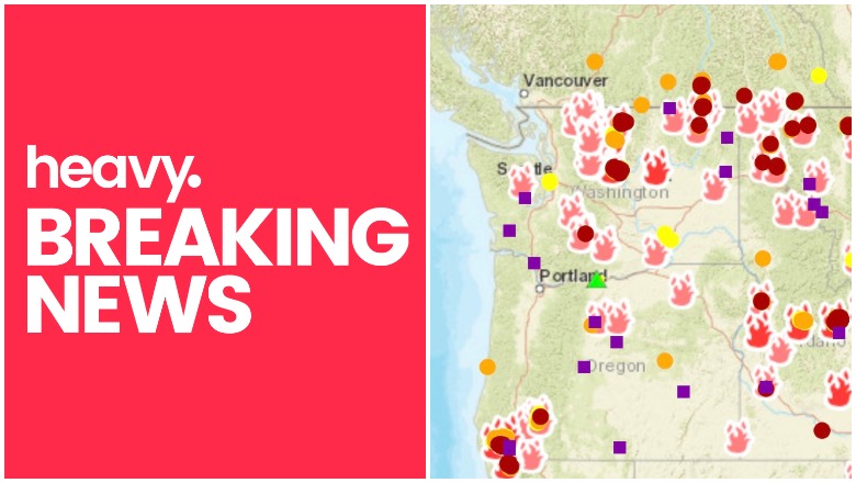
These are the latest details about fires in Oregon and Washington as of August 14 to help you track the fires’ locations and updates. You can see an interactive map of the Oregon and Washington fires here, provided by Oregon.gov, or view details from NIFC.gov here. Another interactive map is here. In Oregon there are 10 fires today, totaling 163,847 acres. In Washington there are 13 fires today, totaling 135,578 acres. Read on for details about active fires in Oregon and Washington, according to NIFC.gov and other sources. You can also see an interactive map of southern Oregon specifically, detailing evacuation areas, here. (For updated details for August 15, see Heavy’s new story here.)
See an interactive fire map of the two states below:
Here’s another real-time fire map via Public RAPTOR for the Oregon area:

Here are details on the individual fires.
0905 RN Fire
This Oregon fire in Prineville District is 519 acres and 90 percent contained. It’s 17 miles south of Madras.
Arctic Jim Fire
This North Cascades National Park fire in Washington is 348 acres and 0 percent contained. It’s two miles southwest of White Swan.
Bannock Lakes Fire
This Washington fire in the Okanogan/Wenatchee National Forest is 417 acres and 0 percent contained. It’s 14 miles southwest of Stehekin. This tweet is older but gives you an idea of where the fire is:
Boffer Fire
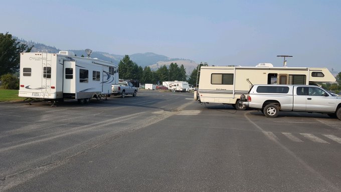
This Washington fire is 5,000 acres and 50 percent contained. It’s two miles south of Kennewick. The current status of the Boffer Fire (sometimes called Bofer Canyon) is “extreme fire behavior.” On August 11, according to The NW Fire Blog, it moved south near Nine Canyon Road and SR 397 from the more populated area of Finley. On that day, the fire also jumped Olympia St. near SR 397, moving east. Evacuation notifications were sent out by Benton County Sheriff’s Office for people in the area of Gamefarm and Oak. Seven structures were lost as of August 12, including four to five homes, according to My Columbia Basin. Two horses and several pets were also injured. No people have been injured in the fire. Officials say they’ve made good progress on the blaze.
Boyds Fire
6:20pm 8/13/18 – The #boydsfire in Ferry County, WA forced significant evacuations in the surrounding area. Dozens of households are currently seeking refuge & services at the Red Cross shelter in Kettle Falls. @spokaneheart providing support for pets. #WaWILDFIRE


This Washington fire in the Northeast Region is 2,922 acres and 0 percent contained. It’s 3 miles west of Kettle Falls (at 48.602 latitude, -118.141 longitude). The cause of the fire is unknown. Primarily west and northwest flanks are uncontrolled; it might spread if the fire re-establishes in the lighter “drier fuels in the bottom of the fire,” per Inciweb. Flyer tankers can’t be used due to the smoke in the area.
You can see a map of the fire in the tweet below.
Some evacuations and road closures are in place. According to Inciweb: “A Red Cross Shelter is located at the Kettle Falls High School for any displaced homeowners. Road closures include SR 20 both directions from milepost 337 Inchelium Rd. to milepost 342. Hwy. 395 is one lane from Barney’s Junction to Boyd’s.” Inciweb has not created an official map for this fire yet.
The fire is threatening hundreds of homes, KXLY reported, and about 800 are without power. Three homes have been lost as of August 13.
Clear Fork Fire
This Washington fire in Gifford Pinchot National Park is 10 acres and 0 percent contained. It’s 12 miles southeast of Packwood.
Columbus Fire
This Oregon fire is overseen by the Umpqua National Forest. It’s 9,636 acres and 15 percent contained. It’s located 15 miles east of Tiller.
Cougar Creek Fire
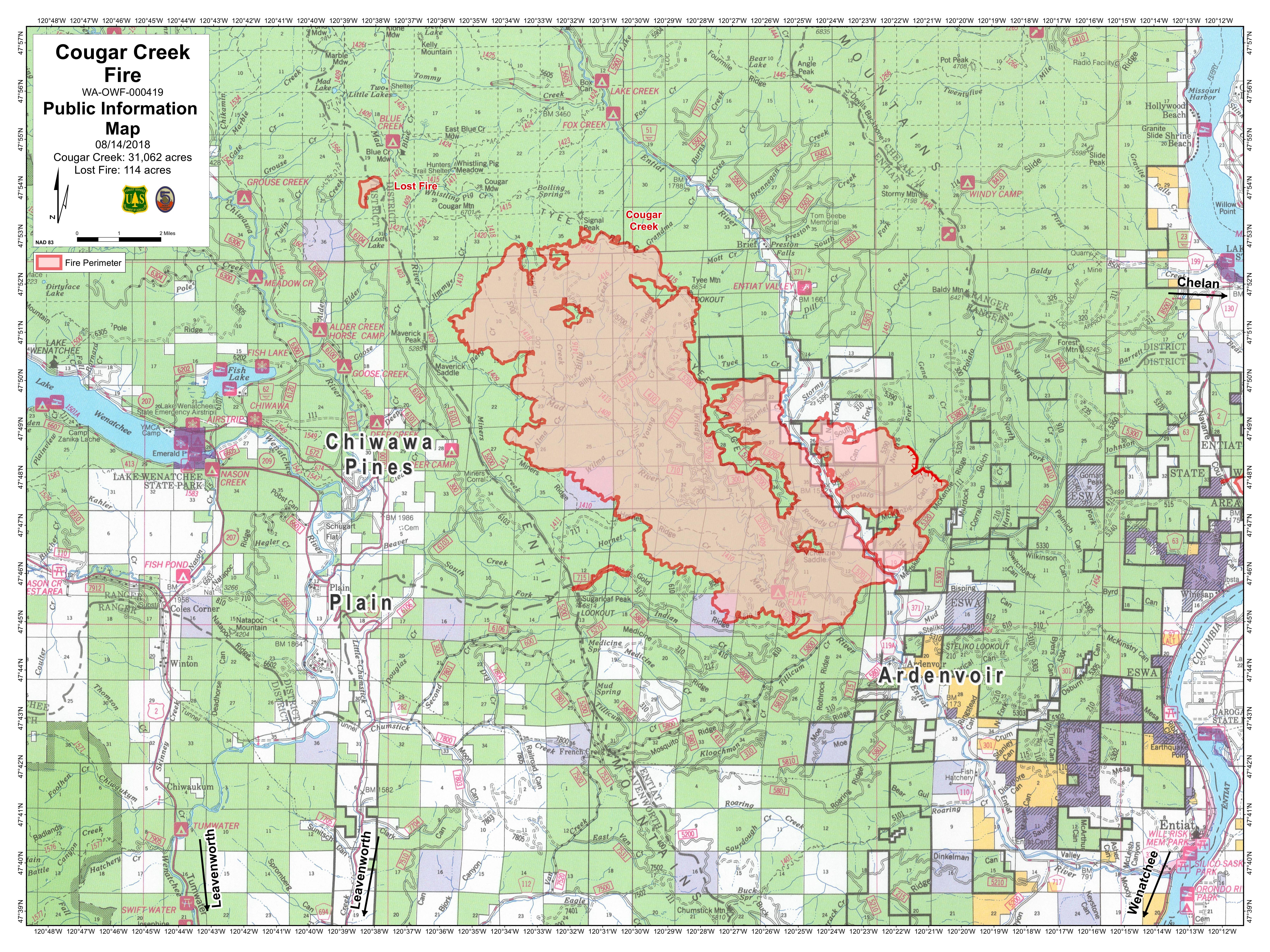
InciwebCougar Creek FIre Map
This Washington fire is now 31,062 acres and just 5 percent contained. It’s 8 miles northwest of Manson, 12 miles northwest of Ardenvior, 7 1/2 miles northeast of Plain, and 20 miles northwest of Entiat. It was caused by lightning.
Tuesday 8/14 #CougarCreekFire Washington. 31,061 acres per infrared analysis by fire staff. See “Legend” and “Map tips” links to get the most benefit from the map. Open online map: t.co/MSwN2REm8i #GeoSpatial

Evacuation levels remain unchanged for August 14. On August 10, the following evacuations were announced, according to Inciweb:
“Chelan County Emergency Management has raised existing evacuation levels at 7:30 pm tonight, Friday, August 10, 2018. The Entiat River Road from Ardenvoir north to the end of the road (approximately to milepost 25) and Mad River Road are now Level 3, which means leave immediately. The Entiat River Road from Crum Canyon (including Crum Canyon Road) up to the southern boundary of Ardenvoir is now elevated to Level 2, which means “prepare to leave at a moment’s notice.”
A new Level 1 Evacuation Notice was issued for the Entiat River Road from US 97A to Crum Canyon, which means time to prepare.”
For specific questions and updates regarding evacuations please call the Chelan County Emergency Management at 509-667-6863. Red Cross can be contacted at 509-663-3907 for
A community meeting will be at 6 p.m. on August 14 in Chelan at the Chelan Performing Arts Center.
The fire is expected to remain active.
Crescent Mountain Fire
This Washington fire is 16,923 acres and 23 percent contained. It’s 18 miles west of Winthrop. It was caused by lightning. It consumed what was originally the Gilbert Fire as of August 9. It started on July 29 in the headwaters of the Twisp River, about 21 miles from Twisp, Washington in the Okanogan-Wenatchee National Forest. You can stay updated on the fire’s Facebook page.
The Level 2 evacuation was expanded, according to Inciweb, but there are currently no Level 3 evacuations in place. The fire is about 1.7 miles from the closest home.
Garner Complex Fire
This fire is no longer listed as active.
Grass Valley Fire
“Worked through the night to stop the fire from getting to Town Hall and then the rest of the town. Around 2am we had a fight. It was like being at the top of a chimney fighting the flames. We won.” Thank you Karl Drechsler for your work out there. #grassvalleyfire #KOMONews
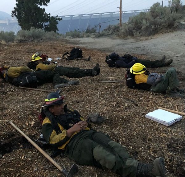

This Spokane District Washington fire is 74,835 acres and 40 percent contained. It’s 16 miles southwest of Grand Coulee.
KHQLOCALNEWS: RT GrantCoSheriff: #GrassValleyFire :: All Grand Coulee and Coulee Dam area evacuation notices downgraded to Level 1
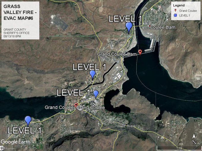
On Monday night, evacuation levels were set to 1, which means to stay aware, but there’s no imminent threat.
Hendrix Fire
This Oregon fire is 1,082 acres, 90 percent contained according to NIFC (Inciweb’s last update lists it as 80 percent contained on August 11 and the August 13 Facebook update lists 80 percent), and 3 to 9 miles southwest of Ashland. The fire was caused by lightning. Containment has increased from 72 percent on August 10, so fire officials are getting a good handle on this one.
According to Inciweb on August 11: “The evacuation level remains at Level 1 for the Jackson County Hendrix Fire evacuation area. Level 1 means BE READY for potential evacuation. Residents should be vigilant and monitor emergency services websites and local media outlets for information.”
For the latest information, go to http://jacksoncountyor.org/sheriff/. Residents in the area are encouraged to sign up for Citizen Alert at http://www.jacksoncounty.org/alert. More information about evacuation levels and preparedness can be found at http://www.rvem.org. You can also follow the Hendrix Fire Facebook page.
Another community meeting is August 10 at 7 p.m. at the Hendrix Fire Command Post at the junction of Highway 238 and Hamilton Road.
Horns Mountain Fire
This Washington fire in Colville National Forest is 667 acres and 0 percent contained. It was caused by lightning and is 12 miles north of Northport, Washington at 48.98 latitude, -118.051 longitude, according to Inciweb. Estimated containment date is August 15.
Klondike Fire
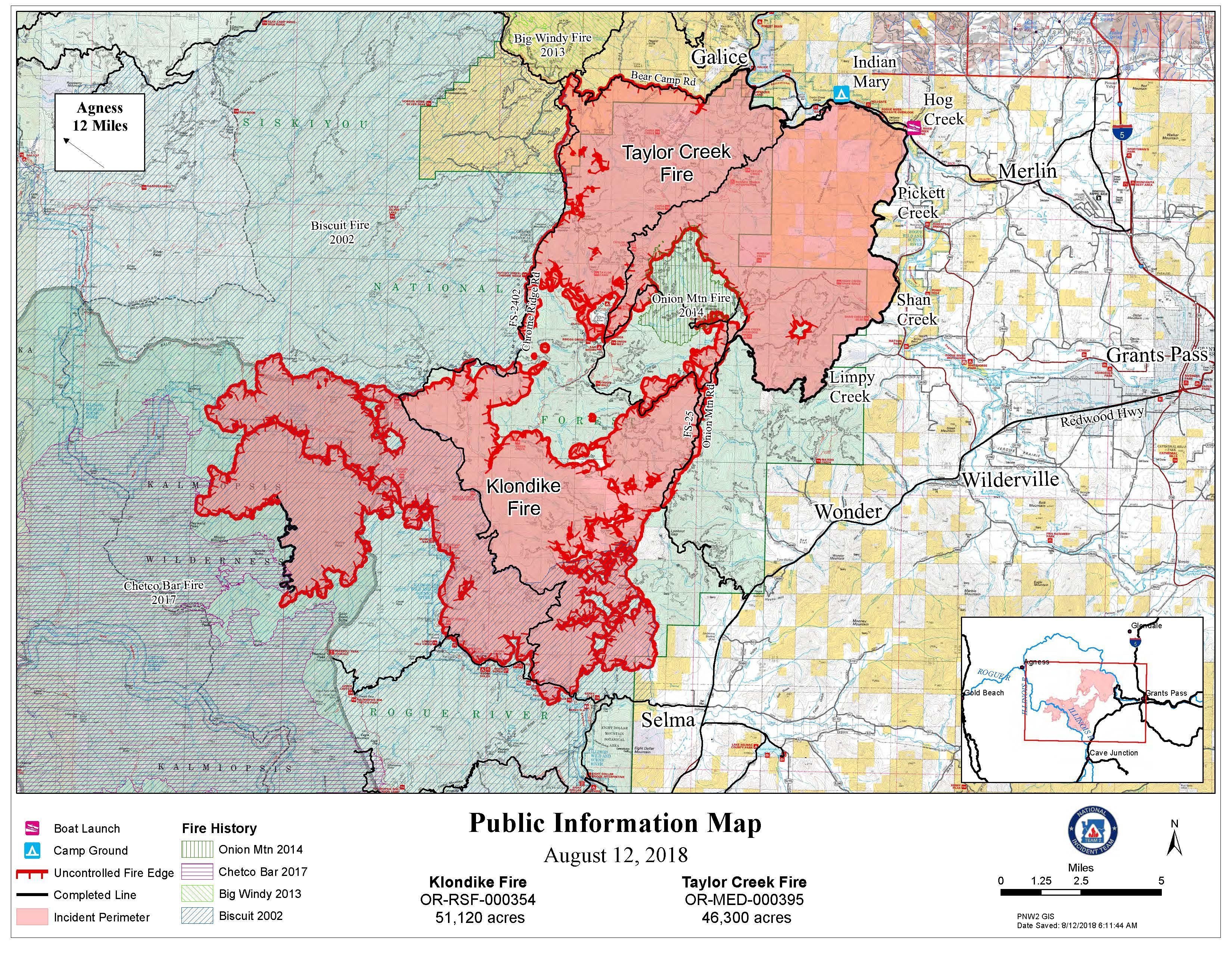
InciwebTaylor Creek Fire Map
This Oregon fire is now 55,248 acres, 15 percent contained and 9 miles northwest of Selma. The cause is lightning. Increased fire activity is still expected.
According to Inciweb regarding evacuations as of August 13: “A Level 3 Go evacuation remains in effect for Oak Flat at the end of the Illinois River Road in Josephine County. Illinois River Road from mile post 2.5 to Oak Flat is at a Level 2 Get Ready. Visit Josephine County Emergency Management on Facebook for current information… Due to the Klondike wildfire, the Josephine County Sheriff’s Office has issued a Level 1 BE READY” notice for the residences west of Hwy 199 between the intersection of Hwy 199 and Lakeshore Drive north to Waters Creek Road. This Level 1 notice also encompasses Hogue Drive, Norman Road, Illinois River Road, Squaw Mountain Road, Clear Creek Drive, Hidden Creek Road, Circle W Drive, Onion Mountain Road, Butcherknife Road, Slate Creek Road and all secondary roads connected with these road systems.”
The Klondike Fire and the Taylor Creek Fire are being managed by the Pacific Northwest Team 2.
Maple Fire
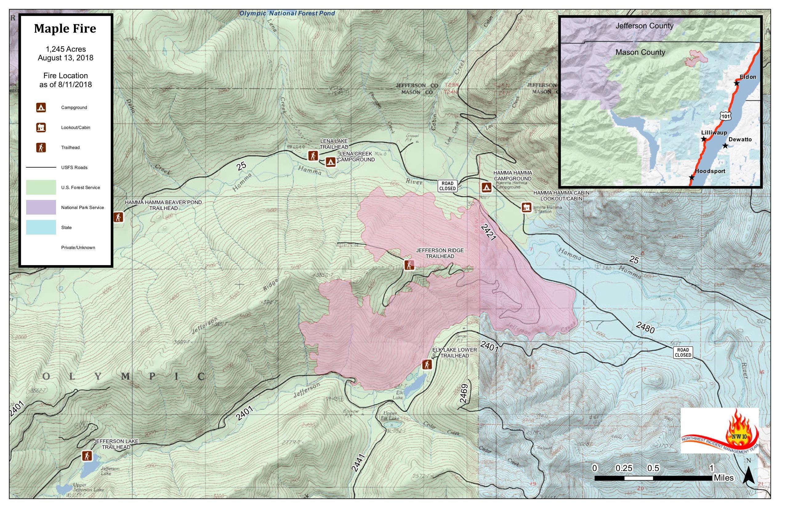
Maple Fire Map
This Washington Fire is in the Olympic National Forest. It’s 1,245 acres and 40 percent contained, located 10 miles north of Hoordsport, 23 miles north of Shelton, and five miles west of Highway 101. It was caused by human activity and is located at47.578 latitude, -123.13 longitude.
McLeod Fire
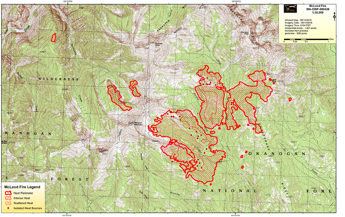
McLeod Fire Map
This Washington fire in Okanogan/Wenatchee National Forest is 1,245 acres and 40 percent contained. It’s 8 miles North of Mazama. It was first reported on AUgust 11 and is currently being mapped. (Inciweb reports that it’s 893 acres, but NIFC reports that it’s 1,245 acres.)
Miles Fire
See fire detection times instantly with a click on a fire symbol. Lead analysis collaboratively with a live map you control. NASA fire detections and GeoMAC perimeters stream in continuously. Measure; download and label views. Real data. t.co/21aXA5VeKx

This Oregon fire is 31,544 acres and 12 percent contained. It’s being managed by the Umpqua National Forest and is five miles northeast of Trail.
Yesterday, authorities downgraded some evacuation notices for this fire, KDRV reported.
Under Level 3 “Go” were: “Trail: Elk Creek Road, all addresses above West Branch Elk Creek Road; West Branch Elk Creek Road, 200-block and the upper section; Sugar Pine Road, all addresses; Dodes Creek Road, all addresses; north side of Lost Creek Lake (uninhabited, accessed by Takelma Drive).”
Under Level 2 Be Set were: “Trail: Elk Creek Road from Highway 62 to the 1600-block; Highway 62, 26300 through the 31600-block (odd numbers only); Takelma Drive, all addresses; Cole M. Rivers Road, all addresses; the uninhabited area west of West Branch Elk Creek Road, including Morine Creek Road, Buck Rock, and the upper Lewis Creek drainage.
Prospect: 4000-block Lewis Road; Ulrich Road, 829 and above.”
Under Level 1 Be Ready were: “Prospect: Lewis Road from Highway 62 to the 3000-block; Evergreen Drive and all intersecting roads; Highway 62 between Lewis Road and Prospect Access Road; Cascade Gorge Road, all addresses; Ulrich Road from Highway 62 to the 820-block; Shelly Lane, all addresses; Mill Creek Drive between Highway 62 and Prospect Access Road; Snodgrass Lane, all addresses; Mather Road, all addresses; Skookum Lane, all addresses.”
Miriam Fire
InciwebMiriam Fire Map
This Washington fire is 2,250 acres and 10 percent contained. It’s 15 miles east of Packwood and 2 miles southeast of White Pass, in the Okanogan/Wenatchee National Forest. It was caused by lightning.
Here are evacuation details as of August 14, according to Inciweb and Yakima Valley Office of Emergency Management: “Evacuation levels around the Rimrock Lake area have been adjusted as of 8-13-2018. Please see the Yakima County Office of Emergency Management Facebook page https://www.facebook.com/yakimacountyoem for a full description.”
Yakima wrote on August 13: “All Level 2 Be Set Evacuations around Rimrock Lake have been dropped to Level 1 Be Ready. Indian Creek cabin and Indian Creek Campgrounds have been reduced from Level 3 GO! to Level 1 Be Ready while Indian Creek Disbursed camping remains at Level 3. White Pass Ski Area remains under Level ! Be Ready Evacuations. Tieton Road remains closed from FR 1000 – US 12. Bear Creek and Bear Cove residents can return to their cabins but will still need to check in at the security checkpoint on Tieton Road. The fire continues to have minimal growth and sits at 2,250 acres with 10% containment. Please help us say thank you to NW 7 Incident Command Team 7 whose last day on the Miriam Fire will be today. PNW IMT 8 will assume command tomorrow morning.”
Stay updated here.
Natchez Fire
InciwebNatchez Fire Map
This Oregon fire falls under the jurisdiction of the Oregon Department of Forestry Fire, but is also listed on the CAL FIRE map. It’s grown about 2,000 acres, to total 13,155 acres on August 14, and 55 percent contained. It was caused by lightning. It’s located 15 miles southeast of Cave Junction, Oregon, located on the Oregon/California border between Happy Camp, California and Cave Junction, Oregon. Some active surface spread is still expected.
On August 13, Inciweb reported regarding evacuation orders:
“For public health and safety due to wildfire, the Siskiyou County Sheriff’s Office has issued an Evacuation Order for the area south of the Natchez Fire, near the terminus of the South Fork Road (National Forest System Road (FSR) 17N32) and to include an additional residence in the South Fork of Indian Creek.
On August 1, 2018, the Siskiyou County Sheriff’s Office issued an Evacuation Warning for all residences accessed by the South Fork Road (FSR 17N32…) and the Grayback Road north of the junction of the South Fork Road. The warning was issued as a precautionary measure and is still in effect.”
The Warning Area has been expanded to include all residences on or accessed from the Indian Creek/Grayback road from the intersection with Dolittle Creek, north to West Branch Campground.”
Residents in the Warning Area are reminded to be vigilant in the possible event that the Evacuation Warning is upgraded to an Evacuation Order.”
Porcupine 2 Fire
The #Porcupine2Fire off Hwy 218 east of the John Day River is looking good! A few things smoldering here and there. Crews will track down hotspots and continue improving the line today. Fire mapped at 527 acres.

This Prineville District Oregon fire is 486 acres and 30 percent contained. It’s 9 miles east of Clamo.
The #Porcupine2Fire is now more accurately mapped 467 acres. It’s 30% contained with continued interior torching but lines are holding. Firefighters will continue to hold and secure lines tomorrow.
Round Top Fire
This Oregon fire is 154 acres, 95 percent contained, and 8 miles northwest of Prospect. It’s being managed by the Rouge River-Sikiyou National Forest.
Silver Lake Fire
This Washington fire in the northeast region is 345 acres and 75 percent contained. It’s 5 miles west of Cheney.
Snow Shoe Fire
This Oregon fire is in the Umpqua National Forest. It’s 3,816 acres and 95 percent contained. It’s 6 miles northwest of Trail.
Taylor Creek Fire
InciwebTaylor Creek Fire Map
Once considered part of the Garner Complex Fire, this Oregon fire is now being managed separately, according to Inciweb, alongside the Klondike Fire. If you have not signed up for Josephine County Citizen’s Alert, Josephine County’s emergency notification system, you can sign up on line at www.rvem.org. The fire is 10 miles west of Grants Pass.