Powerful winter storm continues hammering Maritimes into Sunday

A formidable storm raking Atlantic Canada will continue producing hazardous conditions throughout the Maritimes through the overnight hours into Sunday.
Prolific snows are falling across much of New Brunswick, while warmer temperatures farther south allow for drenching rains in Nova Scotia and even a spell of freezing rain around the Bay of Fundy.
Winds will increase overnight into Sunday. Gusts up to 100 km/h alongside snow, ice, and wet soils will increase the risk for power outages. Ensure your devices are charged.
Residents are advised to stay off the roads unless absolutely necessary. If travel is unavoidable, use extreme caution, prepare for road closures, and check road conditions along your route.
MUST SEE: Rare widespread chill to hit Canada, kicking off an active pattern
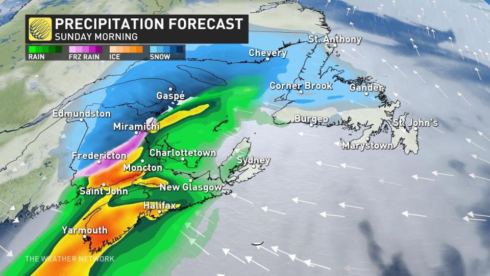
Saturday into Sunday: Heavy snow and rain spread across the Maritimes
Heavy precipitation spread across the Maritimes through the day Saturday as a potent storm rolled up the coast.
Cold air over the northern Maritimes makes this an all-snow event for much of New Brunswick, while warmer air pushing in from the ocean leads to rain and mixed precipitation for Nova Scotia and the Bay of Fundy.
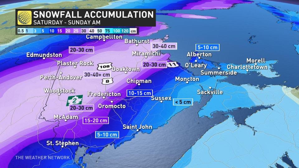
Snowfall rates may approach 4 cm per hour overnight for northern and central New Brunswick. Drivers will want to avoid Highways 8, 107, and 108 across the province through the night.
A wide swath of 30-40+ cm of snow will fall across the hardest-hit areas of New Brunswick through Sunday. This includes Fredericton, which is on track to see nearly a month’s worth of snow from this one storm alone.
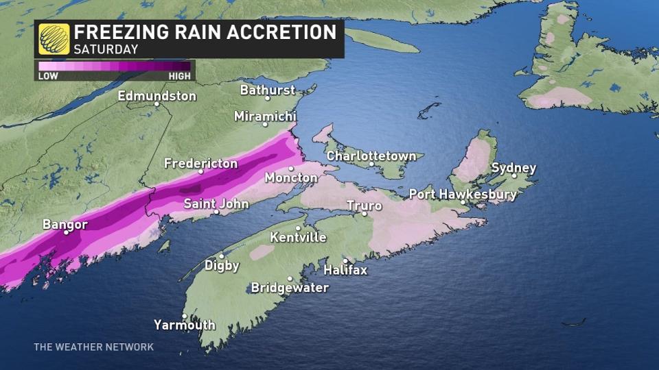
A bit of warmer air moving ashore could lead to some mixing and ice accretion south of Fredericton and north of Saint John. On Sunday morning, a period of icing and mixed precipitation sinks south to Saint John as temperatures fall.
The precipitation will change back to snow before gradually easing off through Sunday.
Drivers are urged to plan ahead and to adapt to deteriorating road conditions. The heavy, wet snow and icy conditions could also heighten the risk for power outages.
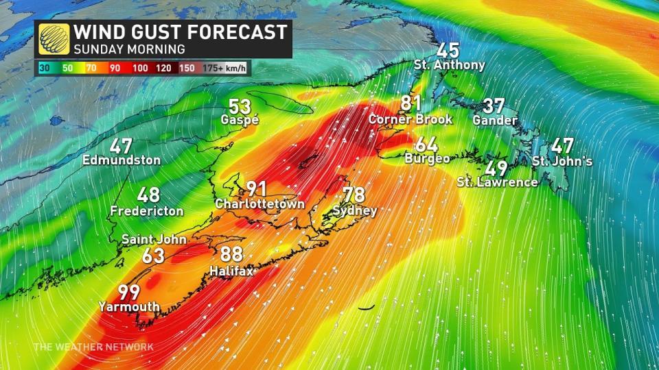
Wind gusts up to 100 km/h are possible Sunday morning as the core of the storm moves through the region. This will increase the risk for power outages, especially alongside the weight of the snow and ice on limbs and power lines. Rain-soaked soils will make it easier for trees to fall in the blustery conditions.
Rain will pose the primary threat for communities across southern New Brunswick and much of Nova Scotia. Rainfall rates will intensify through Sunday morning, with a brief period of mixed precipitation expected as the system pulls away from the Maritimes.
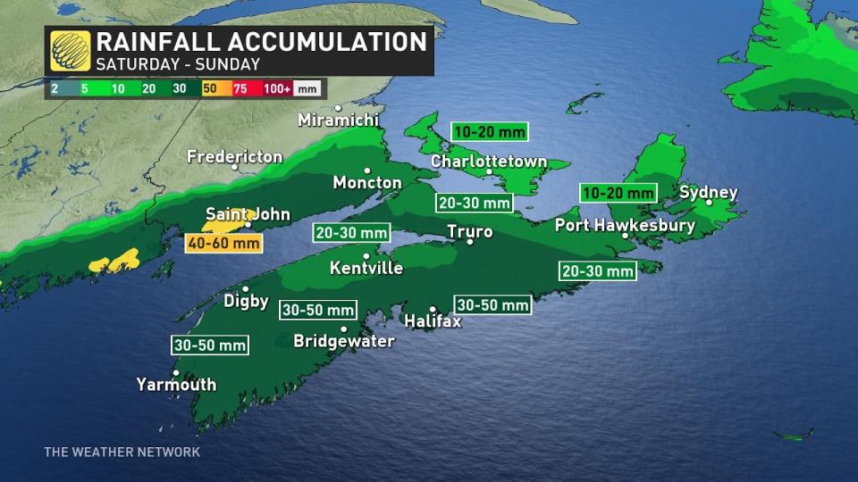
40-60 mm of rain is expected across southwestern New Brunswick, with widespread totals of about 30-50 mm on tap by the end of the storm in Nova Scotia. Localized flooding is possible in low-lying and vulnerable areas.
Conditions will settle down behind this system through the beginning of the week, with a renewed opportunity for active weather returning by the middle of the week.
Stay with The Weather Network for all the latest on your forecast across Atlantic Canada.

