Five years ago this weekend, Nebraska was on the brink of a statewide disaster.

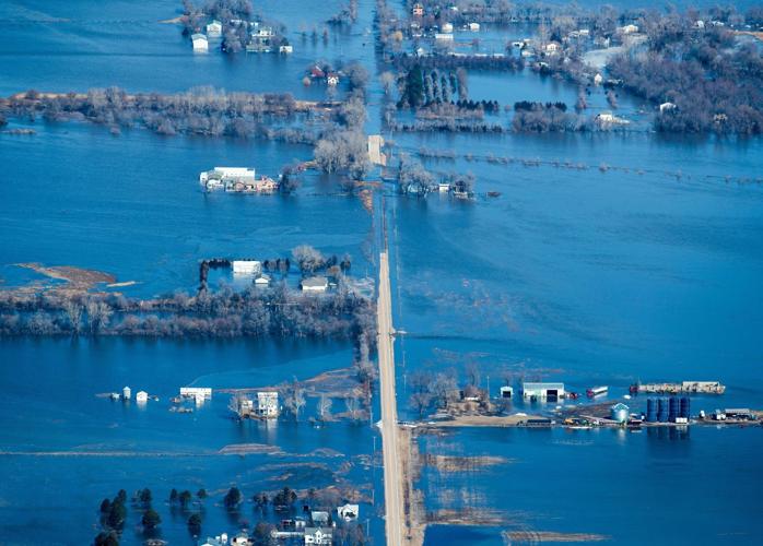
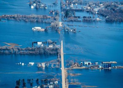
Water covers a road near Valley, Nebraska, on Friday, March 15, 2019.
The massive flooding that hit the region days later claimed five lives and caused an estimated $3.4 billion in damage in Nebraska, as many of the area's rivers swelled to record levels.
In March 2019, floodwaters caused the collapse of a dam in northeast Nebraska and breached 41 levees across the state, inundating some communities. For days, the flood stranded the 27,000 residents of Fremont, Nebraska.
The flood swamped or threatened roads and railroad tracks, an Omaha wastewater treatment plant, Lincoln's drinking water wellfields, and other critical infrastructure. It poured into parts of Offutt Air Force Base and the Nebraska National Guard's Camp Ashland, costing more than $1 billion to repair. It destroyed homes and businesses, killed livestock and ravaged farmland.
People are also reading…
Across an eight-state region, damages totaled $13.1 billion from a historic event considered "one of the costliest U.S. inland flooding events on record."
This week's anniversary of the flood is more than an opportunity to remember the devastating event and the efforts still underway to rebuild and recover. It's also a chance to examine whether the region and its residents have emerged better protected and better prepared for the next flood.
The exact confluence of weather conditions in 2019 — bitter cold, heavy snow and already-sodden, frozen soils followed by a rapid warm-up and a bomb cyclone — created an arguably unique disaster. But it's also a certainty that major floods can and will happen again in this region carved by water, particularly with a warming planet fueling more frequent and potent storms.
Local officials say the region is more prepared for another flood of the same magnitude, although there still is work to be completed.
Many structures repaired, new ones 'built for resiliency'
Sizeable pieces of damaged infrastructure have been rebuilt, many to a higher standard than before. Two levees along the Platte and Missouri Rivers — R613 and R616 — that protect Offutt and the Omaha's Papillion Creek Wastewater Treatment Plant and parts of Bellevue, for instance, have been repaired and raised an average of about two feet, said John Winkler, general manager of the Papio-Missouri River Natural Resources District.
Erv Portis, assistant director of the Nebraska Emergency Management Agency, said some 440 applicants sought funds — mainly federal dollars — for more than 2,000 projects to repair public infrastructure, including roads, bridges and sewers. About half have been completed. He estimated those repairs will approach $600 million by the time they're completed in several years. It can take a decade — or two — for disaster recovery to wrap up.
But he noted that the list of projects goes beyond protective structures to include initiatives intended to mitigate future hazards and boost resilience. To keep a future flood from impacting its well, for example, Peru last month connected to Auburn via an eight-mile pipeline to get its drinking water, a $5 million project.
Plattsmouth eventually plans to shutter its water treatment plant along the Missouri River and instead tap a Metropolitan Utilities District plant near LaPlatte for drinking water. The community also is building a new wastewater treatment plant out of the floodplain, which will eliminate flood losses and the need to send untreated wastewater into the Missouri.

Construction continues on Plattsmouth's new wastewater treatment plant that's intended to be safe from flooding.
"These hazard mitigation projects are being built to eliminate these repetitive losses," Portis said. "They're built for resiliency."
Other efforts are aimed at improving communities' ability to plan for and respond to floods. The Lower Platte North NRD has worked with the Papio NRD, Dodge County, the City of Fremont and the U.S. Geological Survey to add high-quality cameras along the Platte River, said Eric Gottschalk, the Lower Platte North's general manager.
In response to the 2019 flood, the Nebraska Department of Natural Resources and NEMA recently launched the Nebraska Real-time Flood Forecasting tool, which can quickly produce inundation maps that visualize where water is expected to go based on predicted river stages. Such maps are local agencies' No. 1 request when floods threaten, said Jamie Reinke, division manager of the DNR's floodplain management section. But in the past, they have taken considerable time to create.
A two-year grant from the Nebraska Department of Economic Development, funded using federal money, will go toward improving awareness and resilience in flood-prone communities through threat identification, community outreach and mitigation planning. Led by Zhenghong Tang, a professor with the University of Nebraska-Lincoln's College of Architecture, the project launched Jan. 1 and will focus on Douglas, Sarpy and Dodge Counties. He and others recently met with Fremont-area residents.
Meanwhile, the Army Corps of Engineers has been conducting what's known as the Lower Missouri River Flood Risk and Resiliency Study to reassess the flood risk on the lower Missouri River, from Yankton, South Dakota, to Herman, Missouri. The study does not address management of the upstream dams.
After the 2019 floods on the lower Missouri, the corps was urged by the governors of Nebraska, Iowa, Kansas and Missouri to "do something different" when it came to flood resiliency. As part of the study, the corps also is updating flow and stage frequencies on the lower river in order to provide accurate tools for flood risk management.
Colleen Roberts, a program manager with the corps' Kansas City District office, said the agency now has two more decades of data than the last time it examined flows in 2003. In general, the agency is seeing more extremes in high flows and low flows.
The agency has identified some problem spots and this summer begin to talk about possible solutions and who can address them, she said. A draft of the study will be available in 2025 followed by the completed study in 2027.
Work remains to protect communities from floods
These before-and-after satellite images show the full extent of 2019 flood devastation in Nebraska.
Despite all the repairs completed so far, however, work remains to protect communities along rivers, and weaknesses will remain even after scheduled work is done. Some private levees along the Platte, Missouri and other rivers were damaged and have not been repaired, Winkler and others said.
The Platte River levee that protects Camp Ashland near Ashland, Nebraska, for instance, has been reinforced. But the camp, a Nebraska National Guard training facility, still is vulnerable from Salt Creek, which overflowed into the camp in 2015 and 2019. To mitigate the impact of future floods, the Guard raised buildings to allow water to flow without causing extensive damage. Guard officials also hope to work with other agencies to come up with a flood-control plan to direct overflow into the Platte before it reaches the camp.
Iowa plans to seek out potential levee weak spots, which could lead to opportunities for upgrades. The state launched an Office of Levee Safety within its Department of Homeland Security and Emergency Management in June as part of a larger levee improvement program.
Levee safety officials, who met recently with residents in Council Bluffs and Sidney, Iowa, are tasked with analyzing the condition of the state's levees and developing a rating scale to identify those most at risk. The Iowa Geological Survey will survey nearly 900 miles of levees in the coming years.
Meanwhile, local agencies have continued to buy out flooded properties to mitigate future flood risk. The Papio NRD, tapping federal dollars, purchased about 130 flood-damaged homes or cabins in the Bellevue area between 1993 and 2019, said Lori Laster, a stormwater management engineer with the NRD. That avoided some damage in 2019.

In Omaha and throughout Nebraska and Iowa, here's how cities and towns have rebuilt after the 2019 flood — and what work still remains.
But that buyout process can be slow. Seven residents in the area were interested in buyouts after 2019, but only one is still pursuing that path, she said. In the King Lake area in northwest Douglas County, 50 residents initially were interested in buyouts, but the NRD expects only 10 to follow up by the time a grant expires in June. Buyouts also have been offered in many other communities.
For residents of hard-hit communities, flood recovery efforts remain front and center and the trauma lingers.
In others, the pandemic, the passage of time and several years of drought have eroded memories of the 2019 event. In much of the Omaha metropolitan area, high water had little direct impact. Much of the community's interior, including the downtown area, is protected by topography, levees and flood walls as well as zoning rules and dam projects.
"When we're talking about the 2019 flood, the larger metro area outside of those along the Missouri or Platte Rivers, didn't see a lot of flood damage," Laster said. "People say, 'Oh, we were really lucky.' But actually there's been about 60 years of planning, construction and regulation that went into keeping us safe at that time."
World-Herald staff writer Steve Liewer contributed to this report.
Coming Monday: How Offutt Air Force Base and the Nebraska National Guard's Camp Ashland are being rebuilt after the 2019 flooding.

Flood of 2019: The aftermath and the recovery

Nebraska’s disastrous weather in 2019 caused more than $3.4 billion in losses, according to a recently released federal report. Read more

A 92-year-old dam that collapsed March 14, 2019 amid had been classified by state inspectors last year as having a “significant” risk of causing damage.
A man who lived in a home below the dam, Kenny Angel, was swept away in the collapse and is presumed dead, and a quarter mile section of U.S. Highway 281 was washed out. Read more

A four-member team from the Association of State Dam Safety Officials, a national nonprofit organization, will conduct an independent review of the Spencer dam.
The review will focus on what can be learned about the dam collapse to guide future dam construction, according to Lori Arthur, a spokeswoman for the Natural Resources Department. Read more

Even the U.S. Air Force couldn’t stop the Mighty Missouri River from flooding Offutt Air Force Base. Between March 16 and 17 sandbagging efforts were called off as flood waters began to rise. Read more

Six months after what 55th Wing officials describe as “historic and disastrous” flooding swamped one-third of Offutt Air Force Base and destroyed 137 structures, the expected costs of rebuilding continued to mount.
Lt. Col. Chris Conover, who spearheaded the recovery and reconstruction project, said in September that the figure stood at $790 million in September. He warned the cost most likely would rise further — perhaps even hitting $1 billion. Read more

The Platte River swelled into Fremont, turning the city into an island.
Shelters in Fremont alone counted up to 1,100 people, with more evacuees expected from Snyder, Nebraska. And those numbers don’t capture the swaths of people riding out the flood in hotel rooms or crashing on the couches of family and friends.
Those who decided to evacuate left by plane, train line and automobile. There were departures by boat, by airboat and by massive military vehicles with jacked-up frames capable of cruising through waterlogged roads. Read more

Hundreds of people filled Christensen Field Arena in Fremont to hear a National Weather Service update on this year’s flood risk Feb. 4.
The crowd received a nuanced, but somewhat reassuring, explanation from National Weather Service hydrologist Dave Pearson. Read more

Before the water even reached the community, Paradise Lake residents were sent mixed messages.
Law enforcement officials went door to door encouraging residents to evacuate, Paradise Lakes residents received a different message from their landlord: Your homes are safe. Read more

The Bellevue City Council voted to condemn the community and told residents that they had until the end of July to take action on removing their homes. The remaining structures were expected to be razed by a city-hired company in early August.
Jim Ristow, Bellevue’s city administrator, said in August that officials are now taking a cautious approach moving forward because they don’t want taxpayers to be on the hook for the estimated $1.2 million needed for demolition.
Paradise Lakes’ owner, Howard “Howdy” Helm, has told the city that he can’t afford the cost of demolition. Read more

The U.S. Army Corps of Engineers sought bids to close the breach in the south bank of the Platte River that had stranded the city’s water treatment plant during the March flooding.
For months, the plant was accessible only by boat. Now, the water is gone, but Plattsmouth officials have wondered for how long. Read more

Plattsmouth notched a major victory in September when its flood-battered water treatment plant got back up and running, ending months of water rationing.
But the city’s ongoing battle with the waters of the Platte River isn’t over. Read more

Winslow floods.
One in 1996 brought water inside town and into basements, but it was nothing like the surge of water that clobbered Winslow in mid-March, when historic flooding struck parts of central and eastern Nebraska.
So the residents of this little village — where the population that hovered around 100 before disaster struck — are pondering a pivotal question about its future. Go should they stay or should they go? Read more

A group of state and federal officials who met in Winslow in January said plenty of hurdles stand in the village's way.
Those obstacles include state law, the likely millions of dollars needed to put in new streets and utilities in Winslow 2.0 and its dwindling population.
"We all want what's best for Winslow, I want to make that abundantly clear," said Molly Bargmann, a recovery supervisor for the Nebraska Emergency Management Agency. "We want to get to yes, but there's a lot of no's right now." Read more

On St. Patrick’s Day weekend 2019, a violent chute of water raged through a gash in the levee that for decades protected the Nebraska National Guard’s main training site from the Platte River. Floodwaters surged into classrooms, barracks and offices, wrecking furniture and tools and leaving a muddy watermark 5 feet high on inside walls.

The Nebraska National Guard learned in January that it will receive full funding, totaling $62.3 million, to fully rebuild the Camp Ashland training site, according to a statement released Wednesday by the state’s adjutant general, Maj. Gen. Daryl Bohac. Read more

Tons of sand, sediment and silt — some in dunes as high as 10 feet — were scattered across the eastern half to two-thirds of the state by the March flooding. In some areas, washed-out cornstalks are 3 to 4 feet deep. Tree limbs are in piles and topsoil was washed away. Read more

Trish and Salvador Duran hosted Christmas this year for their extended family, an act of hospitality that once seemed impossible after almost 4 feet of floodwater swept into their house in King Lake in March.
King Lake is an unincorporated area, a secluded neighborhood of 1 square mile that sits next to the Elkhorn River and not far from the Platte River, east of Valley and north of Waterloo. During historic flooding in March, the Elkhorn spilled out of its banks, sending water into almost all of the 111 homes in King Lake. Read more

Pacific Junction, with a population of less than 500, was hit hard by levee failures in March that sent floodwaters streaming into town, filling every structure with feet of water. It wasn't until mid-April that the last batch of residents could return to their homes and businesses and start clearing out flood-soaked possessions. Read more

Mills County Democrats worried all month whether many of the 470 former residents of this flooded town would attend a caucus Monday.
Last March, the Missouri River inundated all 210 homes and businesses here, and a caucus day drive through town showed the extent of damage 10 months later. Most local homes, storefronts and gathering spaces remain boarded up. Only about 20 households have moved back so far, officials say, and the only evidence of the presidential race was a single campaign sign in front of the rebuilt home of Rick and Cherry Parham. Read more