On any given morning, when I‘m sitting in northbound traffic on Moreland Avenue, just before the entry ramps to I-20, I’m likely to start gripping the steering wheel and taking deep breaths.
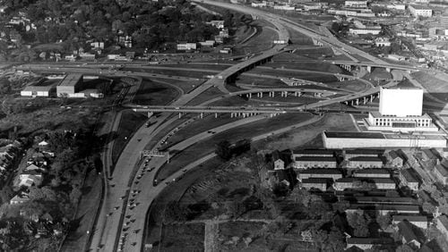
It’s not the bumper-to-bumper traffic that causes me stress. It’s knowing that I am in bumper-to-bumper traffic because city leaders, some decades ago, built this highway to serve as a racial divide.
Interstate 20 “was deliberately plotted along a winding route in the late 1950s to serve, in the words of Mayor Bill Hartsfield, as ‘the boundary between the white and Negro communities’ on the west side of town,” Princeton University historian Kevin Kruse explained in his much-referenced 2019 New York Times Magazine story on Atlanta traffic.
Hartsfield hoped the highway would keep Black residents contained and isolated, out of sight and out of mind, while white residents were left to roam downtown and surrounding areas, patronizing restaurants and shops. City planners didn’t foresee the day when a large number of white people would give up on downtown development and flee to the suburbs. Kruse goes on to explain how I-20 and other poorly placed highways have made traffic worse for all of us.
The racial demographics of people living south of I-20 changed long ago, but the decisions made in the ′50s continue to impact the quality of life on this side of town.
And the same prejudice has prevented us from creating a mass transit system to help alleviate gridlock. But that’s a story for another day.
I have lived in Atlanta for almost 20 years in neighborhoods all around —north of I-20, practically on top of I-20 and, finally, south of I-20.
Once, when I needed a new HVAC system installed, I called a company in north Fulton that listed Atlanta among its areas of coverage.
“We don’t go south of I-20,” the representative said.
“Why?“
“We never have.”
“But isn’t that part of Atlanta?”
Silence.
I wondered why a company that serviced Atlanta would not service all of Atlanta and why south of I-20 was still a boundary not to be crossed. Was it the traffic created by the highway or was it an echo of Mayor Hartsfield’s words?
This month, a U.S. Department of Transportation grant of $157.6 million will partially fund the construction of the Stitch – a long-anticipated, 14-acre green space over the Downtown Connector. It’s designed to reconnect Atlanta neighborhoods cut off by the construction of interstate highways.
This is part of the bipartisan infrastructure law approved in 2021. The grant will cover the first phase of the anticipated $713 million project.
The use of federal funds to remedy mistakes is something to celebrate — that is, if we have learned from those mistakes.
Can the Stitch revive neighborhoods decimated long ago by the Downtown Connector? Can it revitalize an area where development plans have been as fleeting as spring?
Darin Givens, co-founder of ThreadATL, a nonprofit advocacy group that promotes good urbanism in Atlanta, told me there will be good outcomes from the Stitch. But he wishes the infrastructure funding had been used to support an existing neighborhood with legacy residents who have suffered from the disconnect created by the highway system.
He’s talking about the places where the disjoined streets make it hard to design bus routes or to walk from one neighborhood to another. The places where car ownership is often the lowest. The places where development is dense, and the population is growing. Places like the neighborhoods south of I-20.
Maybe it’s time to take a more radical approach to righting the past wrongs done by our highways, many of which are in poor shape due to age and neglect. This may sound drastic, but maybe it’s time to tear them down, or at least tear part of them down. It’s not entirely far-fetched. Several cities in New York (Rochester, Syracuse) have done this, and residents are still able to traverse the city.
Givens and other people who know more than I do about these kinds of projects said removing highways, or even parts of highways, probably would not get much political support in Atlanta.
But in an article written for Southern Urbanism, Phil Veasley, a Raleigh-based engineer and former Atlantan, offered a vision of how it could work for I-20.
“I-20 east and west of downtown are ripe for mitigation efforts despite being constantly overshadowed by the Stitch and Midtown Connector plans,” he wrote. “Selective closings of ramps, more pedestrian crossings and active bridges should be considered.”
It would be costly, but it would go a long way in making the city whole again and restoring equity in forgotten neighborhoods, he concluded.
For now, though, we have the Stitch, and those of us down under I-20 will remain stuck on congested streets, or isolated in our neighborhoods. One day, maybe the lessons from the past will revolutionize how we think about the future.
Read more on the Real Life blog (www.ajc.com/opinion/real-life-blog/) and find Nedra on Facebook (www.facebook.com/AJCRealLifeColumn) and Twitter (@nrhoneajc) or email her at nedra.rhone@ajc.com.
About the Author


