Dallas Weather: Large hail falls in parts of North Texas
DALLAS - After two tornado-warned storms Thursday evening, the threat has moved out of North Texas.
The hardest-hit places were Denton and Collin counties.
Portions of Denton County were hit by some of the larger hail stones. Some car and homeowners will now be dealing with damage claims.
People in Flower Mound saw quarter and golf-ball-sized hail along the sides of the road and in nearby neighborhoods.
That's where Hailey Williams was taking her dog for a quick walk after the severe weather passed. She described what it was like when she was driving home from work.

"I was driving on 171, and it sounded like baseballs were hitting my car," she said. "It's pretty wild. I'm from California so to see this is pretty crazy."
In Lantana at the Bartonville line, we found several cars with hail damage parked outside an auto repair shop. An employee said he had just finished doing an oil change on a red Dodge Charger that was heavily damaged.
Across the street, daycare office manager Wrena Crooks came outside to find her Honda Civic heavily damaged from the hail.
"I come out, and here she is," Crook said referring to her car damaged car. Her car had two busted taillights and broken windshields.

Despite the damage, Crooks has a positive outlook. Her mom's boyfriend does windshield replacement. They showed up to help her out.
The city of Celina along the Denton-Collin County lines responded to two structure fires that started during the storms, including one at a home on Penshurst Court.
Fire investigators believe lightning started the fires.
No serious injuries have been reported.
The city says it had sounded warning sirens because of the severe storms.
In Collin County, there were two tornado warnings that came from the same storm, but there was no widespread damage.
A storm that started in Prosper quickly moved into Collin County from Denton County. Strong gusts of winds knocked down smaller branches but nothing serious.
From there, the storm tracked northeast toward Anna. While it regained a Tornado Warning, we didn't see any evidence of tornado damage.
There was some minor damage back near UNT Frisco closer to the Denton County line where the storm was stronger. There was damage to at least one vehicle and some sign damage but nothing major.

For the most part, it seems Collin County avoided the worst of the initial round of storms.
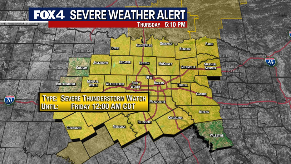
A Severe Thunderstorm Watch remains in place for the majority of North Texas until midnight. After that, the severe weather threat will diminish.
MORE: Dallas-Fort Worth Weather
Evening Updates
9:45 p.m.
Dan Henry has an updated forecast going into overnight.
8:34 p.m.
Viewer video of pouring rain and hail in Aubrey.
8:13 p.m.
Dan Henry says the radar has settled down for the most part, but we could see more storms develop overnight as the cold front passes through.
7:54 p.m.
The Tornado Warning in Collin and Grayson counties has been allowed to expire early since the rotation has weakened.
7:40 p.m.
Several cars have busted out windows and other damage after storms passed through the Collin County town of Lantana.
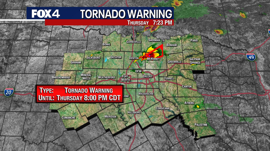
7:26 p.m.
A new Tornado Warning has been issued for Collin and Grayson counties until 8 p.m. Seek shelter now, especially near Anna, Melissa and Van Alstyne.
7:14 p.m.
The storm along the Denton-Collin County line has weakened. The Tornado Warning has been allowed to expire at 7:15 p.m. It has now transitioned into a Severe Thunderstorm Warning.
7:00 p.m.
Sirens going off for the tornado-warned storm in Collin County.
A Tornado Warning has been issued for Denton and Collin County until 7:15 p.m. Seek shelter now if you're in the area.
6:45 p.m.
Rain and small hail coming down in Aubrey.
Pictures of tennis ball-sized hail in Denton County.
6:30 p.m.
Viewers share more hail videos from Roanoke.
Warning sirens are going off in Flower Mound for large hail in the area.
6:15 p.m.
FOX 4 Viewer Kristi Brundage Shoates sent this video of hail falling at her home in Roanoke.
5:50 p.m.
Severe Thunderstorm Warning in Tarrant and Denton counties
5:15 p.m
Dan Henry gives the latest timeline on the severe weather.
5:10 p.m.
A Severe Thunderstorm Watch has now been issued for almost all of North Texas until midnight.
5:00 p.m.
Storms are firing off now, and the main threat is large hail. A Severe Thunderstorm Watch will likely be issued for the area soon.
4:20 p.m.
Storms are popping up in southwest Tarrant County.
4:15 p.m.
Looks like the cap is close to eroding. Showers are popping up across North Texas, and isolated storms will likely develop over the next 1-2 hours before sunset.
4:00 p.m.
3:30 p.m.
So far, the cap seems to remain in place over North Texas, but conditions could change over the next few hours.
3:00 p.m.
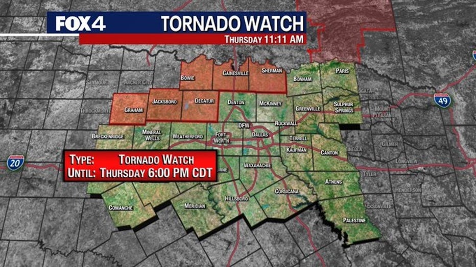
So far, the weather remains quiet for DFW, but a Tornado Watch was issued for counties north and northwest of the Metroplex until 6 p.m.
What is a cap?
Live Radar

LIVE: Dallas-Fort Worth Radar
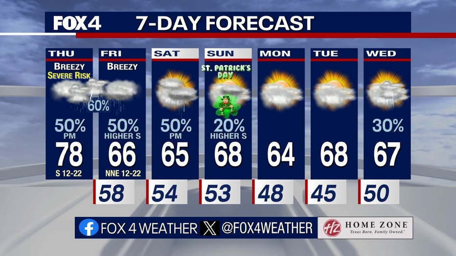
7-Day Forecast
The severe weather risks weaken after midnight.
Cooler air follows on Friday and Saturday with rain showers expected in the middle of the day for both days.
Sunday should be dryer for St. Patrick’s Day, but there could be a shower or two.