First Warn Weather, Madison's certified most accurate forecast by WeatheRate

ALERT DAY conditions to re-develop later today, lasting into Sunday - Jacob

​COPYRIGHT 2024 BY CHANNEL 3000. ALL RIGHTS RESERVED. THIS MATERIAL MAY NOT BE PUBLISHED, BROADCAST, REWRITTEN OR REDISTRIBUTED.

WHAT WE'RE TRACKING: 

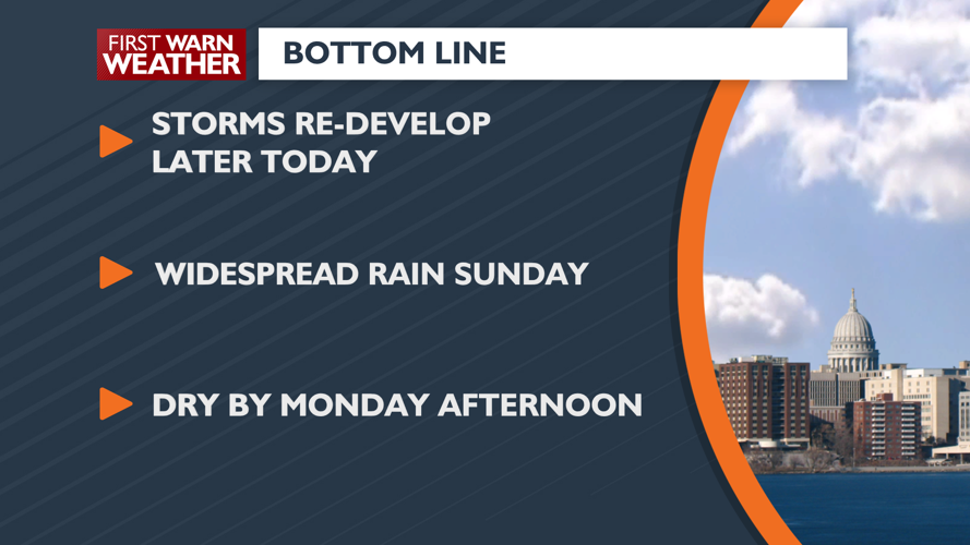
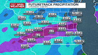
Storms re-develop later today

Scattered showers/storms most of Sunday

Dry by Monday afternoon

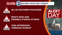
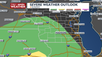
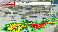
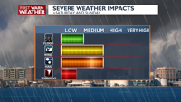
PLANNING THE NEXT 24 HOURS: After a break in thunderstorm activity during the morning, additional thunderstorms, some severe, are expected to develop later this afternoon, lasting into the evening. These storms pose a high wind and large hail threat, but an isolated tornado or two cannot be ruled out.

EXTENDED FORECAST: ALERT DAY conditions are expected again later this afternoon and evening, lasting through Sunday. The First Warn Weather Team is tracking periods of thunderstorms with heavy rain, along with the threat for strong storms during this period. The best chance for strong storms will be this evening, especially if clouds can clear some to allow for the atmosphere to get warm and humid enough. Large hail, strong winds, isolated tornadoes and heavy rain are possible with the storms. Right now, more persistent showers and storms on Sunday may keep the heating down just enough to reduce severe storm chances, yet we will be keeping our eye on any potential for a break for heat to build back up, which would increase severe thunderstorm chances. Next week also looks active, with on-and-off chances of thunderstorms Tuesday through Thursday.

COPYRIGHT 2024 BY CHANNEL 3000. ALL RIGHTS RESERVED. THIS MATERIAL MAY NOT BE PUBLISHED, BROADCAST, REWRITTEN OR REDISTRIBUTED.

Madison, WI

Right Now
63°
Cloudy
  • Humidity: 98%
  • Feels Like: 61°
  • Heat Index: 63°
  • Wind: 17 mph
  • Wind Chill: 61°
  • UV Index: 6 High
  • Sunrise: 05:56:32 AM
  • Sunset: 07:55:05 PM
  • Dew Point: 63°
  • Visibility: 10 mi

Today

Variable cloudiness, breezy, and very mild with a chance for showers and thunderstorms late in the afternoon. Wind: S/SW 10-20 MPH, gusts to 35 MPH

Tonight

Mostly cloudy and very mild with scattered showers and thunderstorms. Wind: S/SW 6-12 MPH

Tomorrow

Mostly cloudy, breezy, and not as mild with scattered showers and thunderstorms. Wind: E 8-15 MPH

Day
Temp
Sat
56°
76°
Sat
76°/56°
Windy with scattered thunderstorms. Highs in the mid 70s and lows in the upper 50s.

Chance of Rain: 40%

Sunrise: 05:56:36 AM

Sunset: 07:55:11 PM

Humidity: 83%

Wind: SSW @ 15 mph

UV Index: 6 High

Saturday Night

Mostly cloudy and very mild with scattered showers and thunderstorms. Wind: S/SW 6-12 MPH

Sun
56°
64°
Sun
64°/56°
Rain. Highs in the low 60s and lows in the upper 50s.

Chance of Rain: 70%

Sunrise: 05:55:09 AM

Sunset: 07:56:21 PM

Humidity: 96%

Wind: E @ 12 mph

UV Index: 3 Moderate

Sunday Night

Mostly cloudy and very mild with scattered showers and thunderstorms. Wind: S 8-15 MPH

Mon
46°
66°
Mon
66°/46°
A few morning showers. Highs in the mid 60s and lows in the mid 40s.

Chance of Rain: 30%

Sunrise: 05:53:43 AM

Sunset: 07:57:30 PM

Humidity: 81%

Wind: SW @ 15 mph

UV Index: 6 High

Monday Night

Partly cloudy and cooler.

Tue
54°
72°
Tue
72°/54°
More sun than clouds. Highs in the low 70s and lows in the mid 50s.

Chance of Rain: 20%

Sunrise: 05:52:18 AM

Sunset: 07:58:40 PM

Humidity: 67%

Wind: SW @ 11 mph

UV Index: 7 High

Tuesday Night

Chance of storms.

Wed
52°
71°
Wed
71°/52°
Partly cloudy. Highs in the low 70s and lows in the mid 50s.

Chance of Rain: 30%

Sunrise: 05:50:54 AM

Sunset: 07:59:49 PM

Humidity: 54%

Wind: W @ 11 mph

UV Index: 7 High

Wednesday Night

Chance of storms.

Thu
49°
65°
Thu
65°/49°
Rain. Highs in the mid 60s and lows in the low 50s.

Chance of Rain: 30%

Sunrise: 05:49:31 AM

Sunset: 08:00:59 PM

Humidity: 77%

Wind: E @ 11 mph

UV Index: 3 Moderate

Thursday Night

Chance of storms.

Fri
43°
62°
Fri
62°/43°
Partly cloudy. Highs in the low 60s and lows in the mid 40s.

Chance of Rain: 20%

Sunrise: 05:48:10 AM

Sunset: 08:02:08 PM

Humidity: 69%

Wind: WNW @ 16 mph

UV Index: 6 High

Friday Night

Mostly Cloudy.

Sat
42°
59°
Sat
59°/42°
Showers possible in the afternoon. Highs in the low 60s and lows in the mid 40s.

Chance of Rain: 10%

Sunrise: 05:46:50 AM

Sunset: 08:03:16 PM

Humidity: 67%

Wind: WNW @ 12 mph

UV Index: 7 High

Saturday Night

Variable cloudiness and cool.

Sun
41°
60°
Sun
60°/41°
A few morning showers. Highs in the low 60s and lows in the mid 40s.

Chance of Rain: 10%

Sunrise: 05:45:32 AM

Sunset: 08:04:25 PM

Humidity: 71%

Wind: NNE @ 11 mph

UV Index: 5 Moderate

Sunday Night

Partly cloudy and chilly.

Mon
46°
61°
Mon
61°/46°
A few morning showers. Highs in the low 60s and lows in the mid 40s.

Chance of Rain: 10%

Sunrise: 05:44:15 AM

Sunset: 08:05:33 PM

Humidity: 69%

Wind: N @ 11 mph

UV Index: 7 High

Monday Night

Considerable cloudiness with occasional rain showers. Low 46F. Winds SE at 5 to 10 mph. Chance of rain 40%.

Radar Loops and Maps

Weather News

AP top story

Powerful storms are rumbling over parts of the southeastern U.S. as more severe weather takes aim at parts of the Ohio Valley. The storm system has already been blamed for at least one death in Mississippi and flooded streets in the New Orleans area. Damage has been reported from Texas to the Florida Panhandle. More than 100,000 customers lack power. Now forecasters say parts of Ohio, Kentucky and West Virginia will be near the bull's-eye of a new area of concern Thursday. The Storm Prediction Center says those areas could see some tornadoes, damaging winds and large hail.