...A SEVERE THUNDERSTORM WARNING REMAINS IN EFFECT UNTIL MIDNIGHT CDT
FOR SOUTHEASTERN OSAGE...NORTHEASTERN CREEK...NORTHWESTERN
OKMULGEE...SOUTHEASTERN PAWNEE AND TULSA COUNTIES...
At 1124 PM CDT, severe thunderstorms were located along a line
extending from 4 miles southwest of Hominy to 5 miles north of Walnut
Creek State Park to 2 miles northeast of Sand Springs to 2 miles
southwest of Kiefer, moving northeast at 50 mph.
HAZARD...70 mph wind gusts and penny size hail.
SOURCE...Radar indicated.
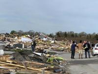
IMPACT...Expect considerable tree damage. Damage is likely to mobile
homes, roofs, and outbuildings.
Locations in or near the path include...
Tulsa... Broken Arrow...
Sand Springs... Owasso...
Bixby... Sapulpa...
Jenks... Glenpool...
Skiatook... Hominy...
Cleveland... Mannford...
Kiefer... Sperry...
Mounds... Wynona...
Westport... Osage...
Blackburn... Jenks Riverside Airport...
This includes Interstate 44 between mile markers 207 and 229.
PRECAUTIONARY/PREPAREDNESS ACTIONS...
A Tornado Watch remains in effect until 300 AM CDT for northeastern
Oklahoma.
Remain alert for a possible tornado! Tornadoes can develop quickly
from severe thunderstorms. If you spot a tornado go at once into the
basement or small central room in a sturdy structure.
For your protection move to an interior room on the lowest floor of a
building.
&&
TORNADO...POSSIBLE;
THUNDERSTORM DAMAGE THREAT...CONSIDERABLE;
HAIL THREAT...RADAR INDICATED;
MAX HAIL SIZE...0.75 IN;
WIND THREAT...RADAR INDICATED;
MAX WIND GUST...70 MPH
...The Flood Warning continues for the following rivers in
Oklahoma...

Caney River near Collinsville affecting Rogers and Tulsa Counties.

&&

...FLOOD WARNING REMAINS IN EFFECT FROM SUNDAY AFTERNOON TO MONDAY
EVENING...

* WHAT...Minor flooding is forecast.

* WHERE...Caney River near Collinsville.

* WHEN...From Sunday afternoon to Monday evening.

* IMPACTS...At 27.0 feet, minor agricultural flooding occurs. County
roads north of Collinsville may be covered with water.

* ADDITIONAL DETAILS...
- At 7:30 PM CDT Saturday the stage was 7.3 feet.
- Forecast...The river is expected to rise above flood stage
early Sunday afternoon to a crest of 27.0 feet Monday
morning. It will then fall below flood stage early Monday
afternoon.
- Flood stage is 26.0 feet.
- http://www.weather.gov/safety/flood

&&
THE NATIONAL WEATHER SERVICE HAS ISSUED TORNADO WATCH 152 IN
EFFECT UNTIL 3 AM CDT SUNDAY FOR THE FOLLOWING AREAS

IN OKLAHOMA THIS WATCH INCLUDES 18 COUNTIES

IN EAST CENTRAL OKLAHOMA

CHEROKEE              MUSKOGEE              OKFUSKEE

IN NORTHEAST OKLAHOMA

CRAIG                 CREEK                 DELAWARE
MAYES                 NOWATA                OKMULGEE
OSAGE                 OTTAWA                PAWNEE
ROGERS                TULSA                 WAGONER
WASHINGTON OK

IN SOUTHEAST OKLAHOMA

MCINTOSH              PITTSBURG

THIS INCLUDES THE CITIES OF BARTLESVILLE, CLAREMORE, EUFAULA,
GROVE, JAY, MCALESTER, MIAMI, MUSKOGEE, NOWATA, OKEMAH, OKMULGEE,
PAWHUSKA, PAWNEE, PRYOR, SAPULPA, TAHLEQUAH, TULSA, VINITA,
AND WAGONER.
...FLOOD WATCH REMAINS IN EFFECT FROM 4 PM CDT THIS AFTERNOON
THROUGH SUNDAY AFTERNOON...

* WHAT...Flooding caused by excessive rainfall continues to be
possible.

* WHERE...Portions of east central, northeast, and southeast
Oklahoma, including the following counties, in east central
Oklahoma, Cherokee, Muskogee and Okfuskee. In northeast Oklahoma,
Craig, Creek, Delaware, Mayes, Nowata, Okmulgee, Osage, Ottawa,
Pawnee, Rogers, Tulsa, Wagoner and Washington OK. In southeast
Oklahoma, McIntosh and Pittsburg.

* WHEN...From 4 PM CDT this afternoon through Sunday afternoon.

* IMPACTS...Excessive runoff may result in flooding of rivers,
creeks, streams, and other low-lying and flood-prone locations.

* ADDITIONAL DETAILS...
- Showers and thunderstorms are expected to develop to the west
of the area this afternoon and increase in areal coverage and
intensity as they move into eastern Oklahoma this evening and
continue into the overnight hours.  Expect rainfall amounts
from 2 to 5 inches to be common, with localized totals from 6
to 7 inches.
- http://www.weather.gov/safety/flood

PRECAUTIONARY/PREPAREDNESS ACTIONS...

You should monitor later forecasts and be alert for possible Flood
Warnings. Those living in areas prone to flooding should be prepared
to take action should flooding develop.

&&