Rain, snow return after days of warm weather in Northern California
A cool, stormy weather pattern is set to return to Northern California after days of warm, sunny weather. The new pattern will bring rain, breezy south winds, isolated thunderstorms and heavy snow to the Sierra.
Storm overview
The next storm system will bring rain, isolated thunderstorms, breezy winds and mountain snow Friday evening and over the weekend.
Overall, minor impacts are anticipated for the valley and foothills, primarily due to slick roads (especially when it first starts to rain). Friday evening through Saturday will be a First Alert Action Day as this storm moves in.
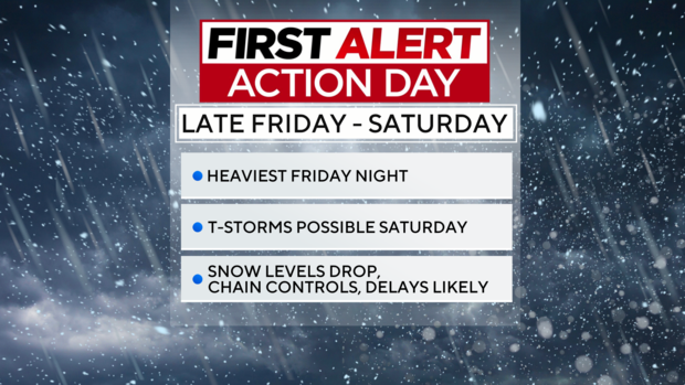
However, isolated thunderstorms may result in dangerous cloud-to-ground lightning strikes, small hail, gusty winds, and brief heavy rain. For the Sierra, snow will cause moderate impacts due to anticipated travel delays, snow-covered roads and possible chain controls.
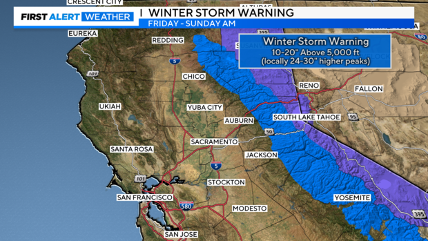
A Winter Storm Warning goes into effect Friday afternoon for elevations above 5,000 feet and it is set to expire early Sunday morning. The heaviest snow is expected to fall over the Sierra Friday night.
Timing the storm
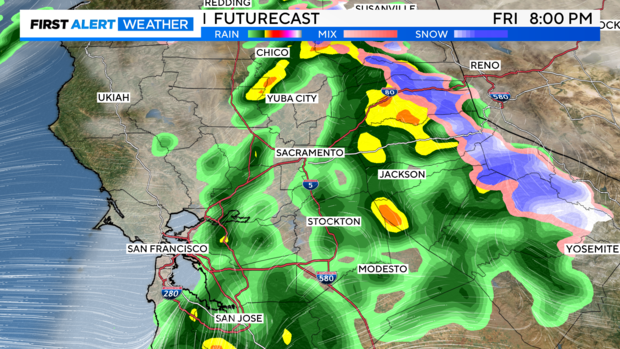
Rain will spread east during the day Friday, beginning over the Coastal Ranges Friday morning and afternoon. Most of the Sacramento and Central Valley will remain dry with overcast skies through the Friday morning commute.
By the afternoon, showers will spread east across the Valley and become widespread during the evening timeframe, especially over the Foothills.
Drivers should anticipate wet roads along with scattered showers on the drive home from work on Friday.
Rain will mix with snow over the higher elevations of the Sierra as initial snow levels hover around 7,000 feet. Snow levels will begin to fall Friday evening with many areas above 6,000 feet turning over to snow by 8 p.m. Friday.
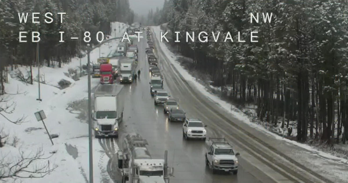
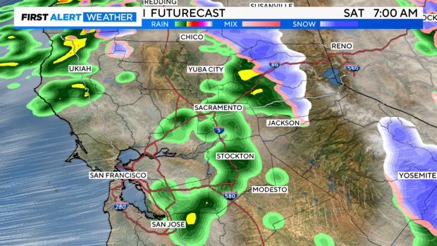
By 2 a.m. Saturday, snow levels will continue to lower below 5,000 feet with widespread moderate to heavy snow. Drivers should expect reduced visibility and snow-covered roads if trying to get over the Sierra passes early Saturday morning.
Moderate to heavy snow will gradually shift south early Saturday morning with lighter snow falling by sunrise Saturday.
Snow will continue off and on through Saturday afternoon and evening, with varying intensity. Expect travel delays and possible chain controls if trying to get to the mountains this weekend.
The valley will not see rain all day Saturday. Instead, the rain will be showery in nature with occasional to frequent showers through Saturday afternoon and evening, with steadier rain focused over the Foothills.
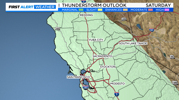
Isolated thunderstorms may develop in the valley and foothills late Saturday morning through Saturday afternoon. Any thunderstorm risk drops off after 5 p.m. Saturday.
Valley showers and Sierra snow will gradually end Saturday evening and Saturday night with lingering snow showers remaining over the Sierra Sunday.
Wind
Wind isn't expected to become much of a problem, but isolated outages can't be ruled out if weak branches come down.
South winds will develop across the valley Friday afternoon with gusts reaching 30-35 mph, especially along the I-5 corridor and northern Sacramento Valley.
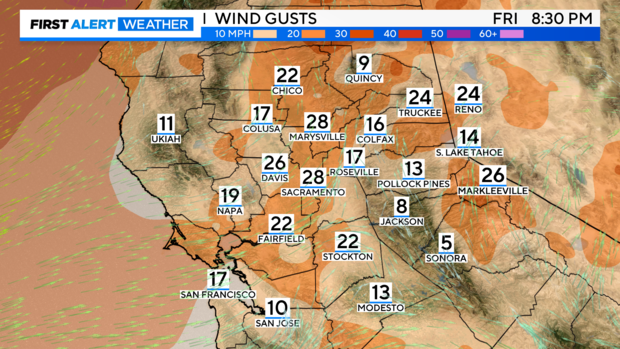
Wind gusts are expected to be stronger over the Sierra with a few gusts to 45 mph possible Friday night into Saturday morning. Overall, these winds will subside by Saturday afternoon.
Rain and snow totals
The valley is expected to receive about a half inch of rain, on average. Rainfall amounts will be lighter over the western Sacramento and Central Valley and higher over the eastern edge of the valley.
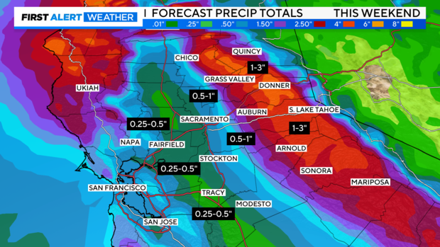
Some spots may pick up an inch or more of rain in these spots, especially if isolated thunderstorms manage to develop. Rainfall totals over the foothills will be higher with many towns averaging 1-2 inches.
Flooding due to heavy rain is not expected at this time.
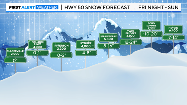
Accumulating snow is expected for elevations above 5,000 feet with the heaviest amounts falling above 6,000 feet.
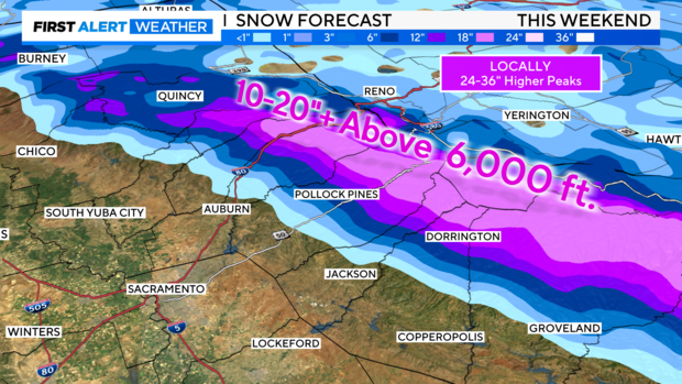
Overall, 10-20 inches of snow is expected for elevations above 6,000 feet. Locally higher snowfall amounts higher than two feet can't be ruled out for the higher peaks.
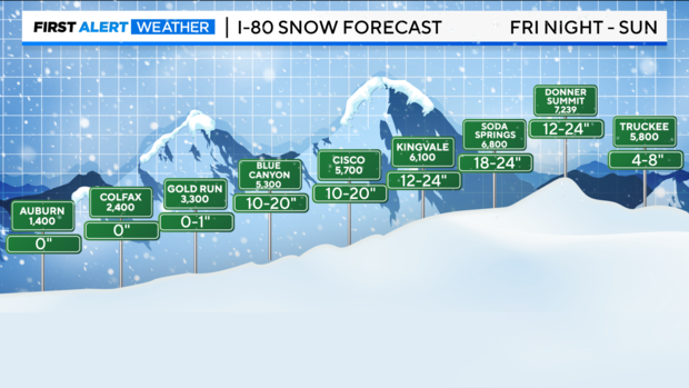
Snow totals climb as you get closer to the pass level from I-80 to HWY 50. Make sure to be ready for winter travel and keep chains on hand if you're traveling over the Sierra.
Looking ahead
Monday through Tuesday of next week look to bring quieter weather, partly cloudy skies and most staying dry.
Another storm threatens to bring another round of rain and mountain snow by the middle of next week. It's far too early to tell exactly what impacts (if any) that storm will bring but the potential is there for another 1-2 feet of snow in the Sierra.
Make sure to stay with the CBS Sacramento First Alert weather team as we work out the details.