The vicious wildfires that rapidly spread across the Texas Panhandle over the past week have been captured in NASA satellite images.
The fires had burned over 1.2 million acres as of Tuesday. A single blaze in Hutchinson County, the Smokehouse Creek Fire, has scorched 1,059,570 acres alone, as of Wednesday, and is 44 percent contained by firefighters, according to the Texas A&M Forest Service. On Tuesday, the fire was only 37 percent contained.
This fire is now the largest in Texas history, overtaking the previous record-holder, 2006's 900,000-acre East Amarillo Complex Fire.
In an update on the Smokehouse Creek Fire, the Texas A&M Forest Service said in a post on X (formerly Twitter): "Crews continue to build and improve containment line across the fire area while patrolling and checking for heat."
Update: the #SmokehouseCreekFire in Hutchinson County is an estimated 1,059,570 acres and 44% contained. Crews continue to build and improve containment line across the fire area while patrolling and checking for heat. #txfire
— Incident Information - Texas A&M Forest Service (@AllHazardsTFS) March 6, 2024
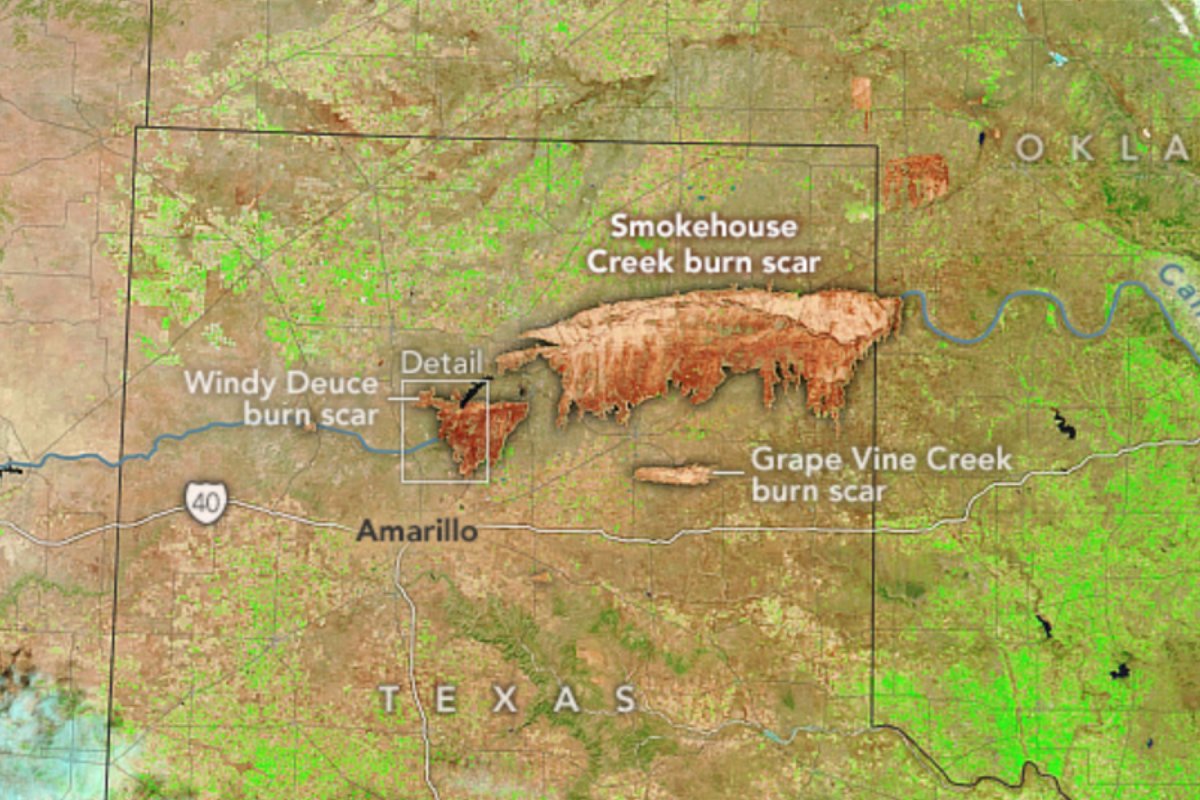
Two other wildfires remain active in the Panhandle: the Windy Deuce Fire in Moore County and the Grape Vine Creek Fire in Gray County. The Windy Deuce Fire is around 142,000 acres and 81 percent contained, while the Grape Vine Creek Fire is 34,882 acres and 77 percent contained.
"Firefighters continue to mop up across the fire perimeter, checking for hot spots near the perimeter," the Texas A&M Forest Service tweeted about the Grape Vine Creek Fire.
Fires began to spark in the Panhandle on February 24 and had spread widely by February 26 and 27, according to NASA data. The burn scar of these blazes was captured in false color by the Moderate Resolution Imaging Spectroradiometer on NASA's Terra satellite on March 2, showing the immense scale of the Smokehouse Creek Fire in particular.
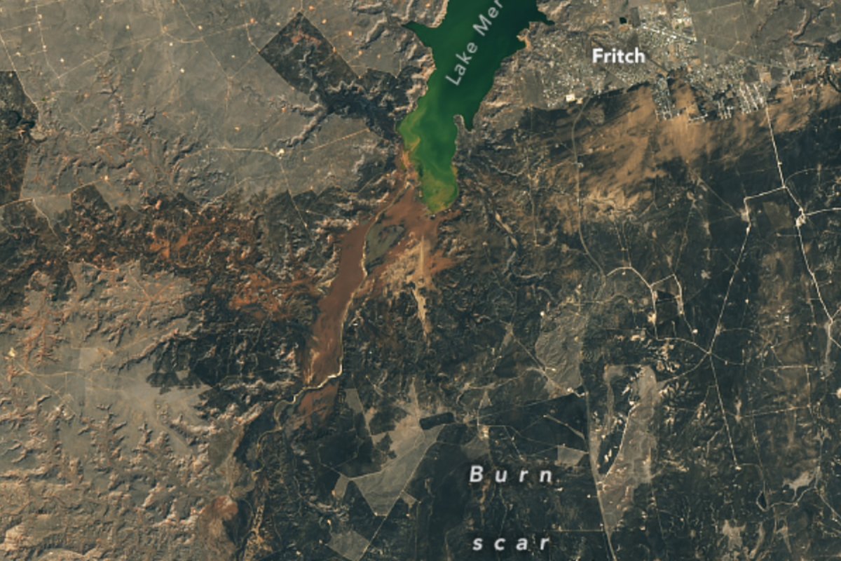
Another satellite image, captured by the Operational Land Imager on Landsat 8, shows a detailed view of the Windy Deuce Fire's burn scar, displaying the scorched land surrounding the town of Fritch and nearby Lake Meredith. Fritch was rapidly evacuated as the Windy Deuce Fire approached its perimeter, with over 50 houses burned to the ground.
The fires have claimed two lives: Joyce Blankenship, who died in her home in Stinnett, and Cindy Owens, who was driving in Hemphill County. The blazes have also killed over 3,600 cattle, as the Panhandle is home to 85 percent of Texas' 12 million cattle population.
"This is calving season across the U.S., so some of the animals lost were likely calves or pregnant cows," said Jessica McCarty, chief of the Biospheric Science Branch at NASA's Ames Research Center, in a NASA Earth Observatory post. "The economic impact of this fire on agricultural communities could be severe."
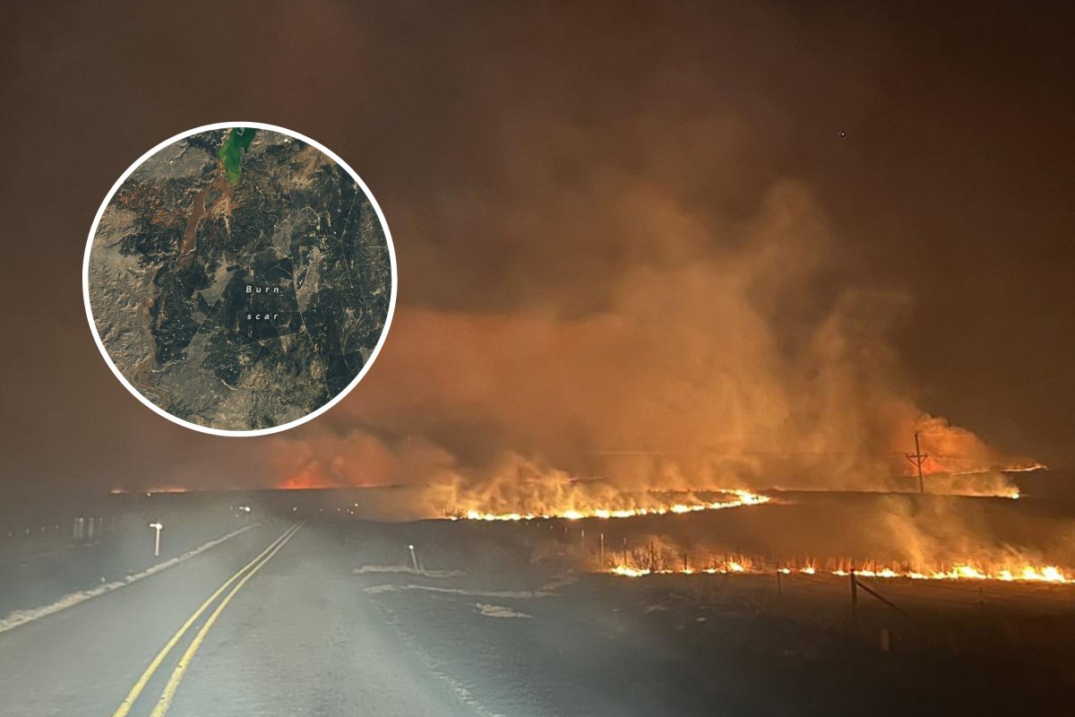
Many of the fires were fought using a technique called backfires, which is when firefighters light fires ahead of a wildfire to burn up all the fuel before it reaches areas like towns. The marks of these backfires can be seen in the NASA images.
"The straight edges in the burn scar generally indicate that an edge of some sort was defended by fighters, often roads or trails, but sometimes a tilled or bladed line in grasslands," said Carol Baldwin, a fire scientist with the Great Plains Fire Science Exchange, in the NASA Earth Observatory post.
"A backfire is lit along the road and allowed to move toward the wildfire, thus depriving it of fuel and encouraging it to go out," she said.
This batch of wildfires is thought to have been triggered by a period of record winter heat and dry weather, combined with strong winds that helped fan the flames. This region was also plagued by droughts during the summer months, further drying out the soil and vegetation and making it a prime tinderbox for wildfires.
"The drought likely made this wildfire more challenging to fight," said McCarty. "Climate change will increasingly make severe fire weather days the standard in late winter and early spring moving forward. Local communities will have to focus on fire prevention, like reducing or eliminating human-caused ignitions to prevent this type of fire from happening in the future."
Do you have a tip on a science story that Newsweek should be covering? Do you have a question about wildfires? Let us know via science@newsweek.com.
Uncommon Knowledge
Newsweek is committed to challenging conventional wisdom and finding connections in the search for common ground.
Newsweek is committed to challenging conventional wisdom and finding connections in the search for common ground.
About the writer
Jess Thomson is a Newsweek Science Reporter based in London UK. Her focus is reporting on science, technology and healthcare. ... Read more
To read how Newsweek uses AI as a newsroom tool, Click here.