Blog: Soaking rains on the way!
HAMPTON ROADS, Va. (WAVY) — Soaking rains are on the way, and they’re rains that could make this the wettest March on record.
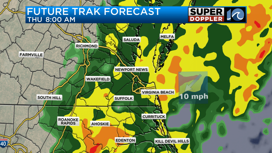
A few showers continue to pass through this evening before the rain developing to our south fills in. Rain filling in later tonight will become heavy through the overnight. Heavy rain will continue all the way through Thursday morning, and may even last until noon or 1 p.m. Thursday.
Flooding will be an issue in spots across town, mainly in low-lying streets/parking lots, so be careful driving around. The morning commute should be a mess, so use caution.

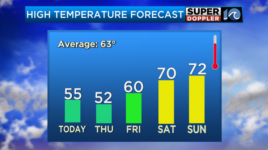
The worst of the heavy rain will likely be Thursday from 12 to 1 a.m. until 12 to 1 p.m. Thursday, with rain totals anywhere from 2 to 3 inches! Fortunately, rain should move out Thursday evening as the frontal system moves offshore. Sunshine takes over with a fresh breeze on Friday and guides us into a warmer, brighter weekend with afternoon temperatures near 70 degrees.
Stay dry!
— Steve Fundaro
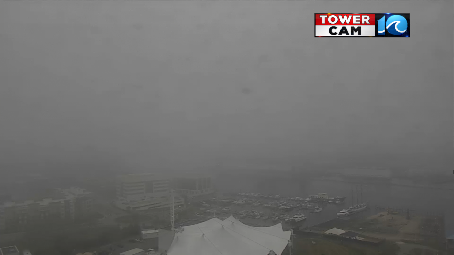
We kicked off this morning with clouds, drizzle, fog, and a lot of moisture.
We have high pressure to our northeast moving offshore. There is still an offshore low that is far out to sea. However, the focus is on a cold front and an area of low pressure just to our west.
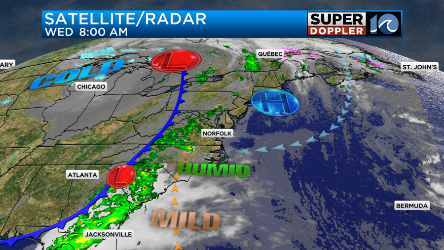
We have a light surface wind out of the east that is pulling moisture in off of the Atlantic. We have moisture coming up from the south and southwest at the mid and upper levels. This large amount of moisture will keep pooling along the East Coast through the day. While we are starting off with drizzle this morning. We will develop scattered rain showers later today.
Luckily the wind will be light. It will be out of the east at only 5-10mph. That means that the tidal flooding will go down today. It will be damp and chilly. High temps will be in the low-mid 50s.

It the showers start up a little sooner, then we’ll probably only land in the lower 50s or even near 50. Either way it will be chilly for this time of year.
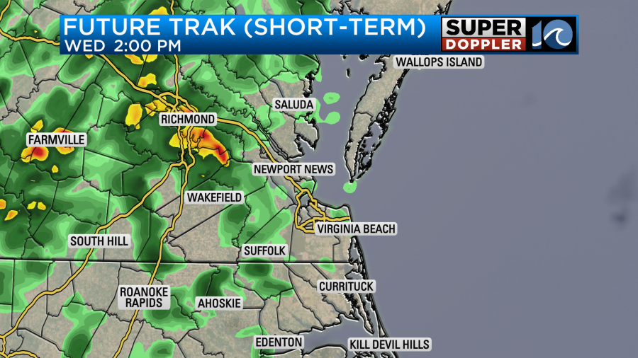
Rain will pick up during the later evening. Overnight it will become widespread and heavy.
The areas of heavy rain will continue into tomorrow morning. This could dramatically impact the morning commute.
The rain will keep going through midday. However, it should start to break up during the afternoon.
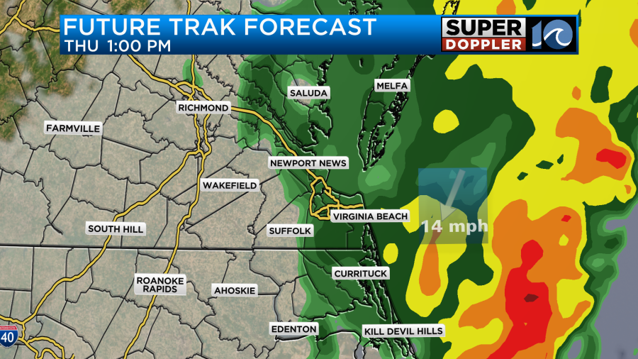
The front and the low will slowly move offshore during that time. Winds will pick up behind those systems. Winds will gust up to 30mph out of the north.
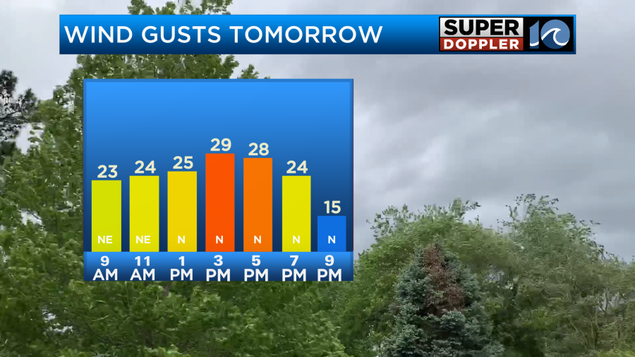
High temps will be in the 50s again. Eventually the north winds will pull down some drier air. We’ll dry out and clear out Thursday evening. Then we’ll have some great weather for the weekend. More on that in a moment.
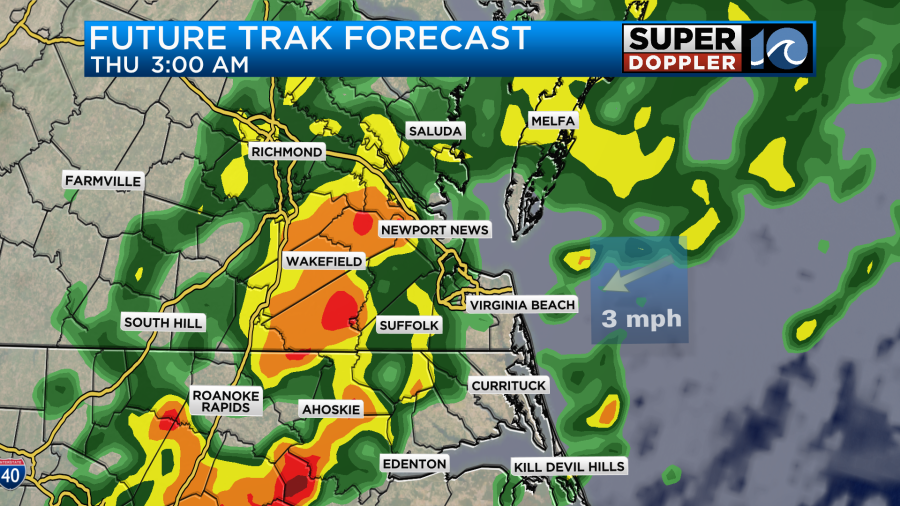
First, I have to talk about the flooding potential for tomorrow. The National Weather Service has posted a Flood Watch for most of the region. It starts this evening, and it goes through Thursday evening.
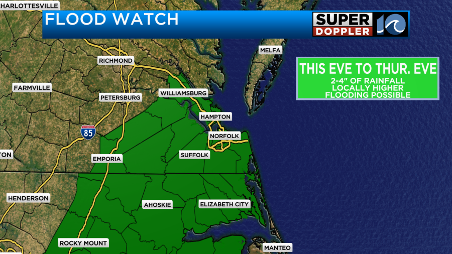
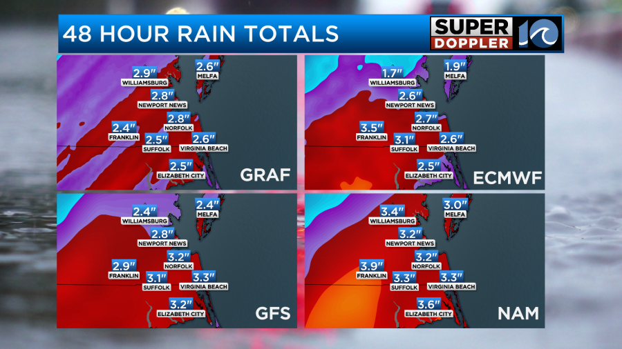
Keep in mind that some more cities and counties could be added to the Watch. The models are in pretty good agreement about how much rain will fall. They are predicting about 2.5 to 3.5 inches solid. They even hint at some areas getting more than 4 inches.
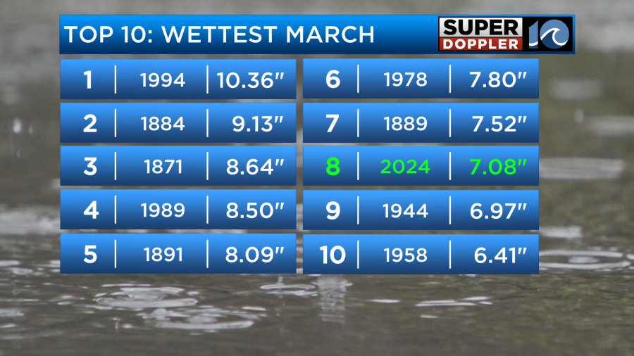
I mentioned it yesterday, but I’ll mention it again. We are already at the 8th wettest March on record. This forecasted rainfall could put us up to the number one spot.
So if we can make it through tomorrow evening then the payoff will be this weekend. We’ll finally dry out. We’ll have partly cloudy skies on Friday with high temps near 60 degrees. It will be a bit breezy, but not too bad. Then we’ll have awesome weather on Saturday. We’ll be partly sunny with high temps near 70 degrees. One of the models hints at an isolated shower in the evening, but we’ll see. We’ll be partly cloudy for Easter Sunday with only some isolated showers possible later in the day. High temps will be in the low 70s.
The nice weather won’t last too long. We’ll have more rain early next week with highs in the 60s. But it will be great to have a drier and warmer weekend for a change.
— Jeremy Wheeler
For the latest news, weather, sports, and streaming video, head to WAVY.com.

