


Three Colorado ski resorts have now surpassed 300 inches of snow for winter 2023-24. Steamboat has notched 355 inches, Winter Park 323 inches and joining them in the No. 3 spot is Wolf Creek with 306 inches.
The snow will continue for Colorado as well, with two storms over the next seven or eight days bringing decent accumulations to all mountain regions.
Recap:
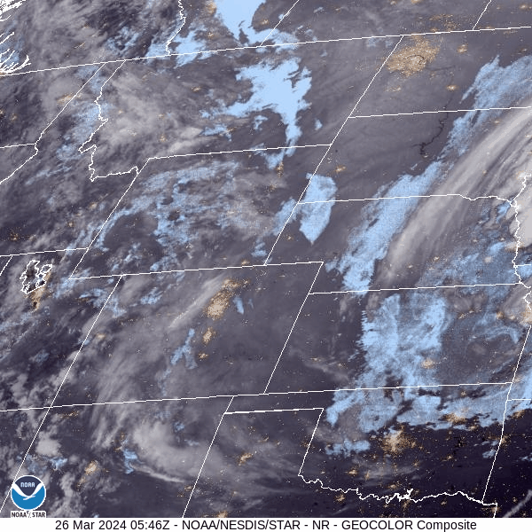
Satellite imagery of over the northern Rockies states between 11:45 p.m., Monday to 8:31 p.m., Tuesday.
Snow fell on Tuesday night in all mountain regions, with accumulations between 0-2 inches in the western mountain, 2-7 inches in the central mountains and 1-3 in the southern, and 1-7 in the northern mountains.
Ski areas and resorts around the state had cooler temperatures on Tuesday too, like at Breckenridge where a high of 29 degrees at the Peak 8 gondola base was recorded, after starting the morning out in the low single digits.
Forecast:
On Wednesday, snow will taper off in the morning before skies slowly clear out from west to east by sunset and into the evening.
On Thursday, the forecast still is looking like a transition day as Colorado will be between storms, but temperatures will remain more winter-like, with high temperatures staying in the low 30s.
By Thursday night, however, storm energy moves into Colorado 6-9 hours earlier, according to the ECMWF high resolution model from Tuesday night.

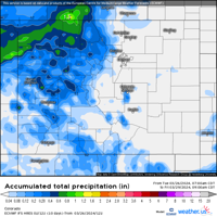
A Weather.us forecast map from the ECMWF model shows the potential total accumulation levels of water-equivalent precipitation as of 9 a.m., Friday, March 29 for Colorado. Depending on the density of the snow, one inch of water is equivalent to 10 inches of snow based on a common rule of thumb ratio of 10:1.
Snow accumulations should mostly be in the western, northwestern and central mountains and range between 2-6 inches in the western and central mountains and 4-8 in the northwestern mountains for Friday's first chairs.
Long Range:
On Friday, snow continues as waves of energy from a low pressure system off the Oregon coast continues to spin moisture eastward across Nevada and Utah.
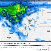
Saturday's first chairs accumulations should be pretty good in the western, northwestern and central mountains with between an additional 6-12 inches, and 4-8 inches for the southern and northern mountains.

A Weather.us forecast map from the ECMWF model shows the potential total accumulation levels of water-equivalent precipitation as of 9 a.m., Saturday, March 30 for Colorado. Depending on the density of the snow, one inch of water is equivalent to 10 inches of snow based on a common rule of thumb ratio of 10:1.
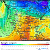
On Sunday, the low pressure system will be west of Los Angeles, California, according to the EMCWF synoptic composite, still spinning moisture into the Four Corners region and producing snow Sunday night through Monday night.

A Weather.us forecast map from the ECMWF model shows the synoptic composite of wind speeds, atmospheric pressure and humidity levels of the air for 10 a.m., Sunday, March 31, for the United States. The reds, yellows and oranges represent moister air and the greens, blues and purples represent less moist air.
Additional snow accumulations between 3-6 inches in the northern and central mountains and 2-4 inches in the southern mountains is forecast.
On Monday, the low pressure system works its way into the Arizona desert and continue pushing moisture into Colorado on southwest flows, with accumulations between 2-6 inches across all mountain regions.
On Tuesday, lingering snow showers could drop another 1-3 inches, but will end in the afternoon.
On Wednesday and Thursday, Colorado is forecast to be dry and sunny with warming temperatures ahead of a storm system arriving from the west on Friday.

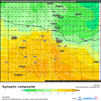
A Weather.us forecast map from the ECMWF model shows the synoptic composite of wind speeds, atmospheric pressure and humidity levels of the air for 7 p.m., Thursday, April 4, for Colorado. The reds, yellows and oranges represent moister air and the greens, blues and purples represent less moist air.
This storm's track has slid a touch farther south after another model run and looks like a good snow event for the western, central and southern mountains.
Snowpack around Colorado has remained around 106% for the better part of a week and should continue holding between 103% to 106% heading into April. April 7 is the median peak day for snowpack, with Colorado's snow water equivalent at 15.6 inches as of March 27, which is 0.2 inches above the 15.4-inch median average level.
Today's 24 hour snow totals from Colorado resorts:
Arapahoe Basin - 1"
Aspen Mountain - 5"
Aspen Highlands - 7"
Beaver Creek - 5"
Breckenridge - 0"
Buttermilk - 2"
Cooper - 3"
Copper Mountain - 2"
Crested Butte - 7"
Echo Mountain - 0"
Eldora Mountain - 1"
Granby Ranch - 0"
Hesperus - Closed for season
Howelsen Hill - Closed for season
Kendall Mountain - Closed for season
Keystone - 1"
Loveland - 2"
Monarch - 4"
Powderhorn - 0"
Purgatory - 0"
Silverton - 4"
Snowmass - 6"
Steamboat - 6"
Sunlight - 2"
Telluride - 4"
Vail - 7"
Winter Park - 2"
Wolf Creek - 3"
 Your Privacy Choices