Storm Isha: Power cuts and travel disruption across Northern Ireland
- Published

More than 48,000 NI homes are without electricity on Sunday evening as Storm Isha causes severe disruption.
NIE said the storm had caused widespread damage to Northern Ireland's electricity network.
In the Republic more than 170,000 premises are without power.
The extreme weather is putting "significant pressure" on the 999 system, police have said, and a "full multi-agency response" is under way.
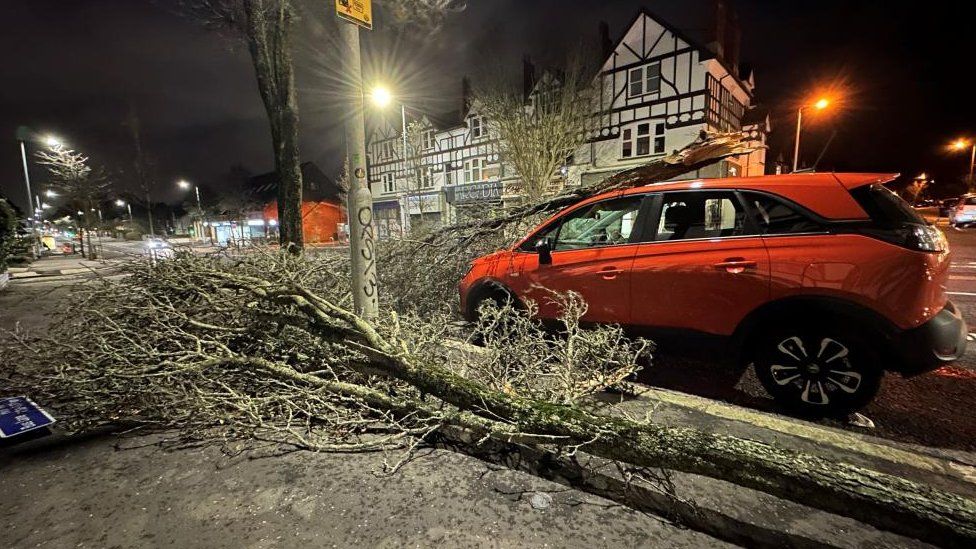
Flights and ferry sailings have been cancelled and road travel affected, with Londonderry's Foyle Bridge closed and fallen trees on the M1.
A ferry due to arrive in Belfast from Birkenhead at 18.30 GMT, remained in the Irish Sea off the County Down coast at 23.30 on Sunday night. Stena Line said its arrival was delayed due to "adverse weather conditions".
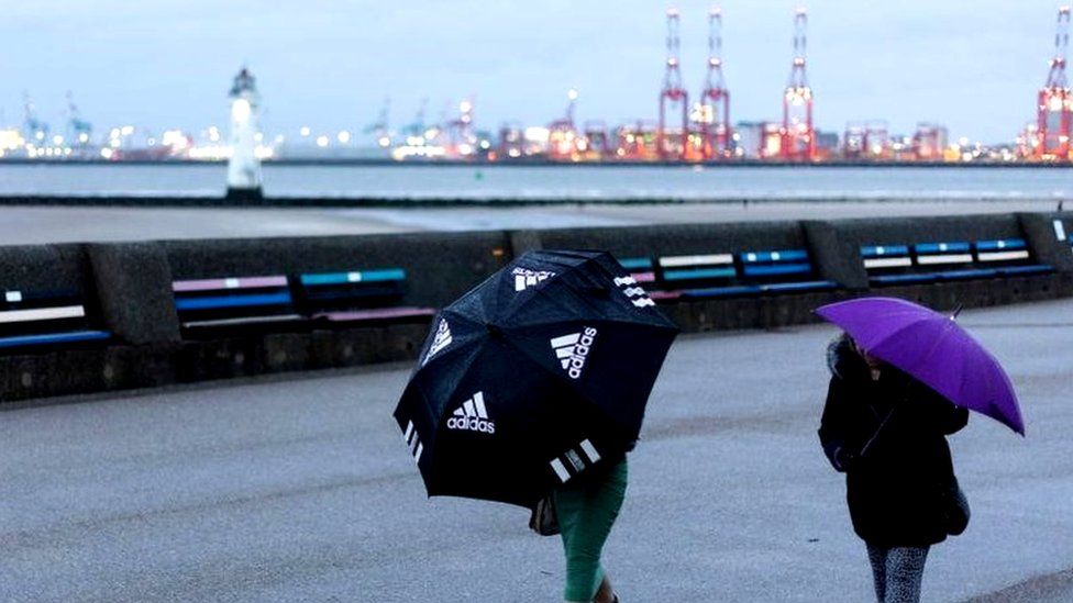
A yellow weather warning for high winds began at noon on Sunday. An amber warning, the second highest level, came into force from 18:00 GMT as the storm increased in severity.
Severe gusts of more than 80mph have been recorded at Magilligan in County Derry on Sunday night.
Winds of 85mph have been recorded on the west coast of Ireland.
The amber alert for Northern Ireland remains in place until 06:00 on Monday.

It means an increased risk of power cuts, damage to buildings, travel disruption, injuries and danger to life because of large coastal waves.
The Met Office has said there is a small chance of peak winds of 90mph (145 km/h) in exposed coastal or hilly areas during this period.
The yellow wind warning will also expire at noon on Monday.
Escalated response
Northern Ireland Electricity (NIE) said it has escalated its response to Storm Isha, with engineers "actively working to restore power after severe weather conditions".
At present approximately 48,500 customers are without power, but this number could rise as the storm progresses, NIE said.
Due to the extent of the damage and the adverse weather conditions, many customers currently impacted will remain without supply overnight.
NIE has said its engineers are "prioritising hazard and extreme faults" on Sunday night.
"Hundreds of extra staff have been brought in to help reinforce our normal capability. Our Incident Management Centre at Craigavon has been opened, as have Local Incident Centres in locations across Northern Ireland to allow our teams to co-ordinate a localised response," a spokesperson for NIE Networks said.
"We have mobilised additional call agents to deal with any queries customers may have regarding the repair process in their area.
"We would like to remind customers that if they should experience a power cut they can report the fault online at www.nienetworks.co.uk or call the NIE Networks Customer Helpline on 03457 643 643. Customers can also follow us on social media for regular updates."
Allow Twitter content?
This article contains content provided by Twitter. We ask for your permission before anything is loaded, as they may be using cookies and other technologies. You may want to read Twitter’s cookie policy, external and privacy policy, external before accepting. To view this content choose ‘accept and continue’.
In the Republic, ESB Networks said more than 170,000 homes, farms and businesses were without power, with the expectation of further power outages.
All Aer Lingus flights between Belfast City Airport and Great Britain were cancelled for Sunday evening.
The decision affected 19 flights due to land or take off at the airport.
All British Airways flights from 18:00 GMT were also cancelled, affecting five services between Belfast City and London airports.
Allow Twitter content?
This article contains content provided by Twitter. We ask for your permission before anything is loaded, as they may be using cookies and other technologies. You may want to read Twitter’s cookie policy, external and privacy policy, external before accepting. To view this content choose ‘accept and continue’.
As of 21;30, Dublin Airport said 148 flights had been cancelled and 35 diverted to other airports, including four to Belfast International on Sunday afternoon.
The disruption has affected thousands of passengers.

'One of the most turbulent landings'
Some of the passengers arriving at Belfast International Airport spoke to BBC News NI on Sunday evening.
A man whose flight from Bristol to Dublin was diverted due to strong winds said it was "a fairly rough" landing in Belfast.
"It was about 300 or 400 meters from landing and it had to pull out of it because the plane was going all over the place," he said.
"We're alive anyway; it could be worse. It's out of [the pilot's] control and our control. As long as everyone's OK that's the main thing."

Another passenger said a flight from Birmingham to Belfast burst into applause after the plane landed.
"Everyone was so relieved," she said.
"I think we were lucky because I don't think planes after ours would have been flying, to be honest.
"I've flown all over the world but that's probably one of the most turbulent landings I've had."
Pressure on 999 system
Gusts of 76mph were recorded in Killowen, County Down on Sunday evening, while wind speeds reached 73mph in Glennane, County Armagh, 72mph in Castlederg in Tyrone, and 71mph at Orlock Head in Down.
The PSNI they are receiving reports of "a significant number of fallen trees" across the road network, including the M1 motorway with multiple trees blocking lanes.
Ch Supt Davy Black said: "The extreme weather is putting significant pressure on the 999 system. Northern Ireland's emergency services are currently responding to a significant number of fallen trees, power outages and other calls for assistance.
"Conditions are likely to remain extremely challenging for some hours and a full multi-agency response, led by the Police service, is underway."
Allow Twitter content?
This article contains content provided by Twitter. We ask for your permission before anything is loaded, as they may be using cookies and other technologies. You may want to read Twitter’s cookie policy, external and privacy policy, external before accepting. To view this content choose ‘accept and continue’.
Members of the public have been urged to report non-emergencies online or via 101 and only use 999 in the case of an emergency.
"Also please only travel if your journey is absolutely necessary, exercise caution and be prepared for obstructions," Det Supt Black added.
Sunday evening's ferry services between Larne, Belfast and Cairnryan have been cancelled, while Monday morning sailings are "in doubt", P&O Ferries said.
Allow Twitter content?
This article contains content provided by Twitter. We ask for your permission before anything is loaded, as they may be using cookies and other technologies. You may want to read Twitter’s cookie policy, external and privacy policy, external before accepting. To view this content choose ‘accept and continue’.

In Belfast city centre on Sunday afternoon, police advised pedestrians to avoid the Castle Lane area.
Officers closed Castle Lane at its junction with Royal Avenue after a member of the public was struck by falling debris. They were treated at the scene by emergency services and subsequently taken to the Royal Victoria Hospital.

The Department for Infrastructure (DfI) hadvised people who need to travel to "exercise extreme caution".
It warned of debris on roads, fallen trees, the possibility of flooding and, in coastal areas, big waves.
The department has also advised that continuing industrial action could hamper response and clean-up operations, and other DfI services in areas affected.
Allow Twitter content?
This article contains content provided by Twitter. We ask for your permission before anything is loaded, as they may be using cookies and other technologies. You may want to read Twitter’s cookie policy, external and privacy policy, external before accepting. To view this content choose ‘accept and continue’.
Severe weather warnings are also in effect for much of Great Britain.
Red alerts issued
Meanwhile in the Republic of Ireland, a number of severe weather warnings are also in place.
A rare red status warning - the highest level - has been issued by Irish weather service Met Éireann for three counties.
The wind alert came into force at 17:00 local time for counties Galway and Mayo, and at 21:00 for Donegal.
Severe and destructive winds are forecast, especially for coastal and exposed areas.
Allow Twitter content?
This article contains content provided by Twitter. We ask for your permission before anything is loaded, as they may be using cookies and other technologies. You may want to read Twitter’s cookie policy, external and privacy policy, external before accepting. To view this content choose ‘accept and continue’.
A yellow warning came into force for the whole of the Republic of Ireland at 11:00 on Sunday.
It was upgraded to 'status orange' on Sunday evening, which will remain in place until the early hours of Monday.
Some flights from Dublin Airport were diverted to other airports, while several had to circle before landing.
Further flight disruption can be expected on Monday.

Ferry sailings between Dublin and Holyhead on Sunday have also been cancelled.
Met Éireann warned of large coastal waves, difficult travel conditions, fallen trees, and damage to power lines.
A status red marine weather warning has also been issued for coastal waters to the north and north west of Ireland, valid from 19:00 local time Sunday until 01:00 Monday.
Ireland's Road Safety Authority (RSA) has warned motorists to slow down and allow extra distance as strong winds hit.
Allow Twitter content?
This article contains content provided by Twitter. We ask for your permission before anything is loaded, as they may be using cookies and other technologies. You may want to read Twitter’s cookie policy, external and privacy policy, external before accepting. To view this content choose ‘accept and continue’.
Storm Isha marks the ninth named storm of the season, which started on 1 September, and is the first storm beginning with the letter 'I' since February 2016.
It follows in the wake of Storm Henk, which wreaked havoc and caused severe damage in parts of the UK in early January.

Once the storm passes there will be some relief from very strong winds until another wind warning comes into force at 16:00 on Tuesday.
It is forecast to stay in place until noon on Wednesday, with more disruption to travel and utilities expected in that period.
However, the timing of that warning could change between now and then.
- Published20 January

- Published22 January
- Published5 April