Storm bringing soaking rain to Massachusetts, over a foot of snow up north
BOSTON - The WBZ Weather Team has issued a NEXT Weather Alert through the day Saturday for a multi-faceted storm system affecting Massachusetts and New Hampshire.
We've got some snow to start, some ice in the hills and, to wrap it all up, another round of heavy downpours and localized flooding.
All in all, a pretty gross Saturday.
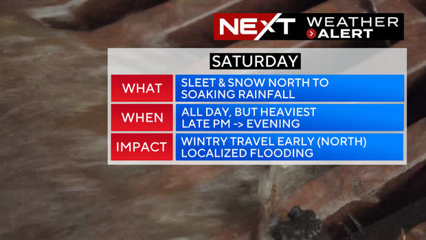
What to expect on Saturday?
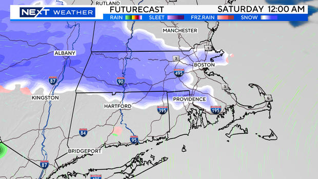
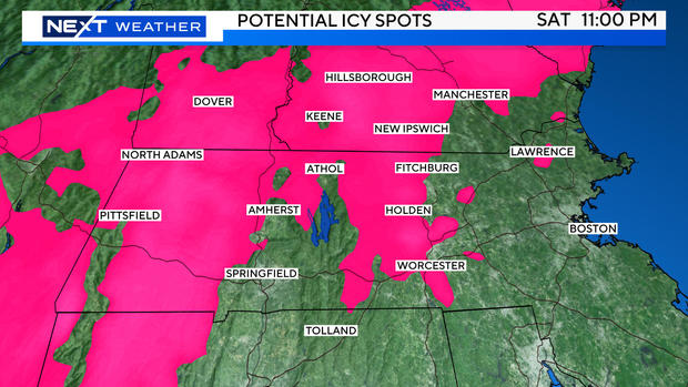
Midnight - 7 a.m. Saturday: Still waiting on the main precipitation shield from the storm to arrive. However, there is likely to be some light, wintry mix north and west of Boston. A mix of light snow and ice is expected through parts of Middlesex and Worcester counties as well as southern New Hampshire.
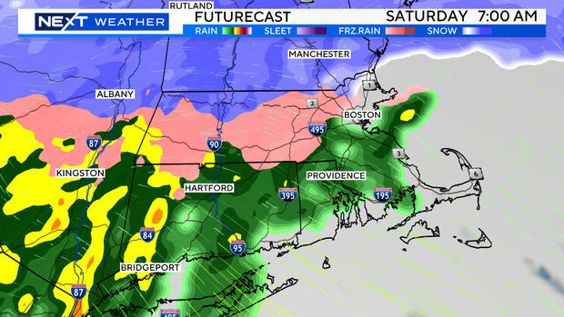
7 a.m. - noon Saturday: Rain overspreads all of southern New England. The snow shield gets shunted into central and northern New England. Some sleet and freezing rain will linger in the elevated areas in central and western Massachusetts where temperatures will be slow to warm. We could see some light ice accretion on the limbs and wires in parts of northern Worcester county.
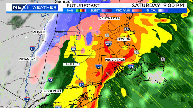
Saturday afternoon through midnight: A washout. Rain gets heavy by late afternoon and between 7 p.m. and midnight it will be absolutely pouring. Temperatures warm into the 40s across eastern Mass. and mid to upper 30s north and west (mild enough for all rain in southern New England).
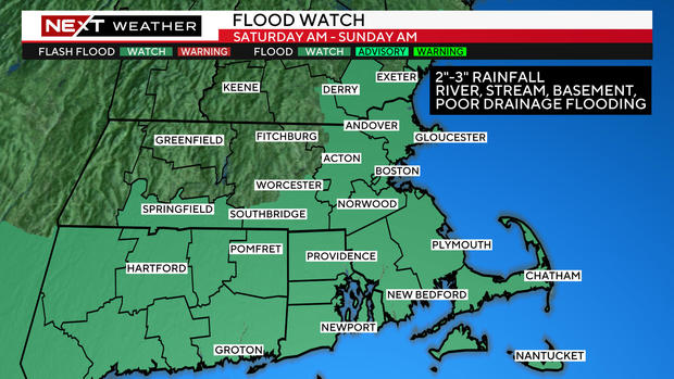
Flood watch for eastern Massachusetts
If you are headed out Saturday night, be prepared for ponding on the roadways. If you live in an area that has been prone to flooding in the last several months (near a small stream, river or pond), you may experience renewed flooding Saturday night. Have the sump pump ready just in case.
The National Weather Service has issued a flood watch for all of eastern Mass. for the potential of river, stream, basement and poor drainage flooding.
The rain tapers off after midnight in most of the area. Southeastern Mass., Cape Cod and the Islands will be last to dry out, between 2 a.m. to 6 a.m. Sunday.
Temperatures will fall below freezing in most areas as the storm departs late Saturday night. Any untreated surfaces could turn treacherous, use caution if you head out early Sunday morning.
Sunday will be dry but blustery and chilly. Clouds will linger in eastern Mass. The farther west you go, the more sunshine.
How much snow and rain will Massachusetts and New Hampshire get?
Most areas will receive between 2-3" of rainfall. Highest amounts are likely to be south of the Mass Pike in Connecticut, Rhode Island and over southeastern Mass. There may be some locally higher amounts (above 3").
The National Weather Service has posted winter weather advisories for central and western Mass. as well as southern New Hampshire.
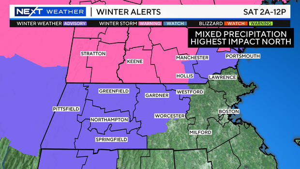
The winter storm warnings (in pink) are posted for areas where there is a better chance of more significant snow accumulations (up to or exceeding 6").
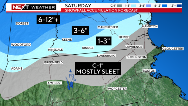
A very early coating to an inch up near the Mass./NH border (mostly sleet), all to be washed away by rain.
Just over the border into southwestern NH and southernmost Vermont there will be 1-3", again snow and a lot of sleet.
From Manchester, NH north to Concord, NH about 3-6".
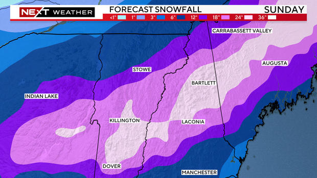
Snow forecast for New England ski country
The snow "jackpot" will be in the Green Mountains and up through central and northern New Hampshire. The state of Maine is also in line for quite a bit of snow on Saturday.
Great news for those looking to get in some spring skiing! 1-2 FEET of fresh snow is expected to fall across most of the northern ski areas.
A bit closer to home, we are concerned about some light ice accretion in central and western Mass. as well as southern New Hampshire during Saturday morning. If you live in an elevated area out that way, check your temperature if you are heading out. There may be some ice on the deck, driveway or on untreated roads.
Wind and coastal issues not major concerns
Wind is not a major factor with this storm. During Saturday night, we could see southeasterly gusts topping 40 mph over Cape Cod and the Islands.
Sunday will be gusty across all of southern New England, but below warning levels. Looking at northerly gusts between 20-35 mph.
Coastal flooding is also not a major concern this go around. Astronomically, the levels are a few feet lower than during our last event. There may be some pockets of minor flooding during the Saturday night high tide (after 11 p.m.) along south or southeast facing beaches across southeastern MA.
Next week we can expect a windy and chilly start, with more wet weather likely mid to late week.