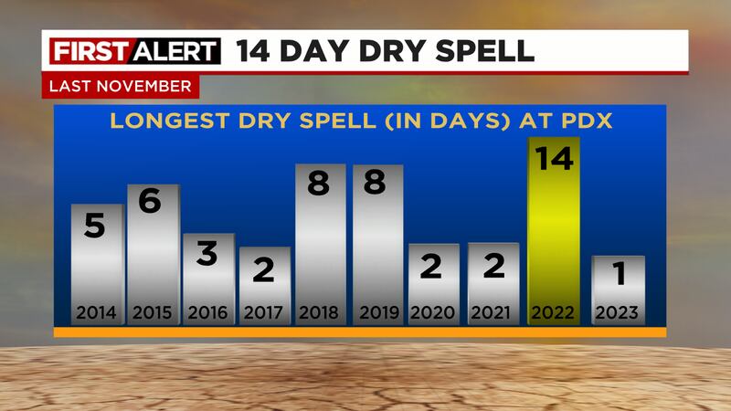
April 2022 and April 2023 were very wet and cool, more than 5 inches of rain fell both months in Portland! This April is much different and it appears the dry weather is here to stay for awhile.
I'm headed out on a trip to see the solar eclipse Monday April 8th. But first a quick update on what we'll be seeing weather-wise heading into early April.
It was a historic warm/sunny/dry period these past 6 days, one of the top 2-3 warm/sunny periods we've ever seen in March! Now we're headed back into a wet/cool pattern for at least a week.
Thursday and Friday mornings are First Alert Weather "Mornings". Wet snow will fall and accumulate in spots as a cool/wet weather pattern continues into the first week of March
After some bright and warm sunshine Tuesday, we expect chilly/rainy/windy weather for the 2nd half of the week. Snow is on the way for the Gorge and Cascades too!
The last two weeks have been very mild to warm, and there's no sign of a cool/wet pattern through mid-month. What that means for mountain snowpack in the blog post
Widespread power outages due to downed trees and powerlines are accompanied by temperatures in the teens this morning. The big storm has begun...here's what we expect the rest of the day
After a calm and mainly dry Friday, another pineapple express brings moderate/heavy rain this weekend. Unfortunately that includes heavy rain falling on the fresh snowpack in the mountains once again
Rainfall has been only light/moderate, but quite persistent for about 24 hours. More rain through the morning commute leaves the I-5 corridor still vulnerable to spots of flooding.
A "Pineapple Express" shifted into Washington and BC today; giving us a record-setting warm and mainly dry day. The rain is back through and we've got one more chance for local flooding as Tuesday is a First Alert Weather Day
Plenty of rain is on the way this weekend, but evening models have backed off. We may get lucky and avoid flooding, but for now we'll continue to call Sunday a First Alert Weather Day
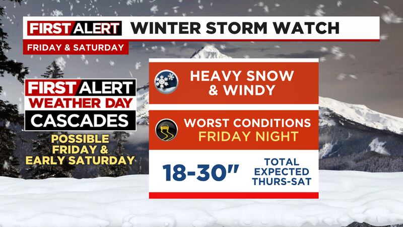
Multiple days of sunshine have been nice, but now as we roll into December a much wetter and milder pattern looms. The transition period means a lot of snow for the Cascades
A slow weather pattern for meteorologists means we've got a surprisingly sunny Thanksgiving weekend forecast, plus a look further ahead into early December
There's no sign of stormy weather, and we'll be drier than normal heading into next week and the big holiday weekend. A look at upcoming snow in the mountains too
You may be surprised that some parts of the metro area get almost double the rain than other parts. Let's take a closer look at yearly average rainfall
Wondering what an "El Niño winter" means for skiing and snowboarding in the Cascades? Mark takes a look at what we might see in the mountains this winter.
Winter is quickly approaching, but what can we expect this year? Mark takes a deep dive into the possibilities during our first "El Niño winter" in 5 years.