
WHAT WE’RE TRACKING:
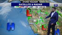
The rain and snow will take a break on Thursday afternoon but by Friday morning, the showers will be back in the area with the next/second storm.
PLANNING YOUR NEXT 24 HOURS:
Showers fall through Thursday morning, while the rain and snow will take a break on Thursday afternoon but by Friday morning, the showers will be back in the area.
EXTENDED FORECAST:
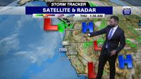
The second round of storms from the northwest will move down the coast from the north and will end up in Southern California by early next week (maybe as early as the weekend). Before the storms end up in Southern California, they will bring widespread rain showers, potential heavy mountain snow along with gusty winds. The mountains could see 12" of snow between Friday and Saturday night (mostly above the 5,000 feet snow level). A half of an inch of rain could fall between Friday and Saturday night for the valley, foothills and lower mountain levels (below 5,000 feet). If the energy is there then there is a slight chance for (isolated) thunderstorms on Friday and Saturday. Showers could linger in the mountains on Sunday but a drier weather pattern (cool, sinking air out of the north) will move in behind these storms Sunday into Monday.
ACTION NEWS NOW STORM TRACKER FORECAST:
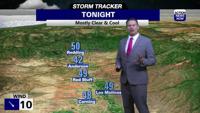
TONIGHT:
Cloudy, cool and breezy with a 90 percent chance of rain mainly before 11 pm with totals around 1/10" to 1/4"
Low: 47
Wind: SE 10-20/G30 MPH
TOMORROW:
Partly sunny, cool and and breezy with a 40 percent chance of rain with less than 1/10" of accumulation
High: 61
Wind: SE 15/G25 MPH
THURSDAY NIGHT:
Mostly cloudy, cool and breezy with an 20 percent chance of rain before 11 pm
Low: 46
Wind: SE 10-15/G20 MPH
FRIDAY:
Mostly cloudy, cool and breezy with a 90 percent chance of rain mostly after 11 am
Low: 46
High: 58
Wind: SE 10-15 MPH
SATURDAY:
Mostly cloudy and cool with a 60 percent chance of rain
Low: 47
High: 60
Wind: N 10 MPH
SUNDAY:
Mostly sunny and mild with a 20 percent chance of rain
Low: 45
High: 64
Wind: S 10 MPH
MONDAY:
Sunny and mild
Low: 45
High: 71
Wind: N 10 MPH
TUESDAY:
Sunny and mild
Low: 47
High: 74
Wind: SE 10 MPH
WEDNESDAY
Mostly sunny and mild
Low: 46
High: 71
Wind: SW 10 MPH
THURSDAY:
Partly cloudy and mile
Low: 44
High: 68
Wind: NW 15 MPH