
On Saturday and Sunday, The Lede tracked the impact of Hurricane Irene as it swept north.
10:28 P.M. Gov. Christie Says to Stay Home from Work
 Rich Schultz/Associated PressGov. Chris Christie, center, and Lt. Gov. Kim Guadagno, right, talked about the beach with Avalon Mayor, Marty Pagliugai, left, while touring the Jersey coast after Hurricane Irene in Avalon, N.J., on Sunday.
Gov. Chris Christie urged people in New Jersey to stay home from work on Monday because of the dangerous flooding conditions on roadways and the rail system across the state, our colleague Jennifer Preston reports. “Traveling around the state is going to be very difficult,” Mr. Christie said.
“The hurricane is over but, as I said, we have serous things to deal with,” Mr. Christie said during a briefing Sunday night at state police headquarters here near Trenton.
New Jersey Transit would not be providing any commuter rail service on Monday, except for limited service on the Atlantic City line to help people who were evacuated return to their homes, he said. NJ Transit bus and light rail service, including the Bergen-Hudson and the River lines, would operate on a limited schedule. PATH service would resume at 4 a.m. Monday.
More than 300 roads across the state were either partially or fully closed because of flooding conditions.
State police troopers used boats to rescue 60 people trapped in their residential neighborhood of mostly single-family homes in Kenilworth. Another 16 people were rescued by boat from a four-story apartment building in Cranford, state police said. More rescues by boat were expected in the coming days because of worsening flooding conditions.
While New Jersey escaped major damage to private property and public infrastructure along the coast, Mr. Christie said the heavy rainfall from the storm was causing some of the worst inland flooding that the state had seen in years.
Many small streams were now at flood level, and some larger rivers – including the Ramapo, Passaic and Delaware — were expected to peak over the next 48 hours, reaching record or near-record flood levels.
Mr. Christie noted that a flash flood had claimed the life of a 20-year-old Salem County woman early Sunday. The woman, identified as Celena Sylvestri, of Quinton, drowned after she was trapped in her car on Route 40 in Pilesgrove Township. She first called her boyfriend and then police shortly after 1 a.m. to report her car was swept off the road and that the water was up to her neck. But police and rescue workers at the scene could not find any trace of her or the car until more than eight hours later.
Meanwhile, 10,000 people who spent last night in state operated emergency shelters were expected to be able to return to their homes Sunday night. More than 1 million people evacuated the Jersey Shore starting late last week.
On Sunday night, more than 700,000 homes were still without power, Mr. Christie said, and it could be five days before power is fully restored across the state.
Mr. Christie surveyed the damage along the coast by helicopter late Sunday afternoon from Sandy Hook to Cape May. He said that he did not see significant damage to private homes and not nearly as much erosion to beaches as had been feared.
He also met with local and county officials in Cape May who, he said, reported limited damage and told him they believed lives had been spared because of the decision to evacuate residents.
Mr. Christie dismissed criticism of his call for mandatory evacuations along some parts of the Jersey Shore. He said that Hurricane Katrina was very much on his mind as he made decisions and preparations for Hurricane Irene. “Watching those folks not having been evacuated, those school buses sitting unused, we all remember those images,” Mr. Christie said, “and I did not want to leave resources on the table and leave people in parts of the southern part of our state where they could end up losing their lives.”
He said that he was glad “we made the decision we did. I think we saved people’s lives.”
He said “second guessers will not be tolerated.”
The southbound lanes of the Garden State Parkway, which had been closed for several days, reopened yesterday. But flooding caused closures on the parkway between Exits 91 and Exits 98 in both directions, making it difficult for some people to get home on Sunday.
Mr. Christie also noted that at 6 a.m. Monday, the state would resume collecting tolls. Casinos will also be open.
The Lede is signing off for the night. We will continue to cover the impact of the storm in the days ahead. In the meantime, please visit the home page of this Web site for more reports from our colleagues. Thanks for your comments and tips.
9:43 P.M. Rivers Run Through Main Streets in Upstate New York
At least three people have died in New York State and hundreds have evacuated from their homes as floodwaters rise in the Hudson Valley and neighboring areas amid torrential rains.
More than a foot of rainfall led to the closure of 137 miles of the New York State Thruway, from Westchester County to Albany, as rivers swelled to record levels. The Tappan Zee Bridge was also closed, and officials were unable to predict when the thoroughfares would reopen.
“This is the highest we’ve seen in years. Our flood stage starts at about 11 feet. We’re approximately 23 feet right now,” Robert Stanely, the supervisor for the Catskills town of Shandaken, N.Y., told The Associated Press. “Immense areas are underwater. Areas I’ve never seen flooded are flooded right now. Dikes are breaking behind homes all over the place.”
Many customers in Greene County and Ulster County were without a electricity, raising the statewide total of customers without power to 936,000, according to estimates put out by the office of Gov. Andrew M. Cuomo.
Extreme flooding has washed out the entire downtown area of Windham, in Greene County, according to Michael Scarey, the town’s fire chief, the Mid-Hudson News Network reported.
Scott Adams, the creator of the comic strip “Dilbert,” who grew up in Windham, posted on his blog on Sunday that his father, who still lives there, is missing and unreachable by phone. “My father lives alone on a hill above where the flooding is, so he wouldn’t be in immediate danger from the high water. But my mother passed away a few months ago and he’s living alone,” he wrote. Mr. Adams requested that people in touch with his father email dilbertcartoonist@gmail.com.
A YouTube User named David France posted astounding video of rescuers using a motorboat to power through the brown river that used to be the Main Street of Margaretville in Delaware County.
At least three deaths in New York were blamed on the weather, according to the A.P.:
Officials said a good Samaritan in New York City’s northern suburbs was electrocuted trying to help a child who had gone into a flooded street that had live wires embedded in it.
In the Albany County town of New Scotland, a woman’s body was spotted in a creek Sunday afternoon after her husband reported her missing, state police said. Neither the identity of the woman nor details were immediately released by police.
In Delaware County, deputies said a woman in her seventies died after floodwaters caused the partial collapse of a motel in the western Catskill Mountain community of Fleischmanns.
A video posted on YouTube purported to be of that town showed rivers coursing down the streets, loaded with giant trees propelled by gushing water.
8:24 P.M. Dramatic Video of Vermont Flooding
Some of the most shocking flood imagery is coming from Vermont, where rivers are gushing over their banks, subsuming cars, pouring into houses and coursing down streets.
“It’s not like anything that we’ve ever seen before,” Peter Shumlin, the governor of Vermont said on CNN. “All of our downtowns are in the lowlands. Our population centers are located near rivers and streams. You just can’t get away from it in a little state like Vermont.”
On a YouTube account named mobilady, a video that seems to be from Bennington, Vt., shows a car hurtling down a river and being dashed on its banks.
The Times’s Whitney Boyd spoke on Sunday evening to John Bohannon, 68, a 25-year resident of Saxtons River, Vt., population about 600.
Mr. Bohannon described a tense scene. The Saxton River has been swelling to the height of the bridges that cross it, forcing their closure. With a steady rain that has not ceased since 10 p.m. Saturday, it threatens to rise higher.
“Just two days ago when I was driving down the road, you could see stones because the water was so low,” Mr. Bohannon said. A trailer home washed away earlier today, he said.
“People in town are amazed, because they looked at this river that we’re so used to being peaceful and go fishing in and it is now knocking down trees and running against our bridges,” he said.
Our colleague Brian Stelter draws our attention to this illustration of the “epic flooding” in Vermont we mentioned in our 4:00 p.m. update: video of raging floodwaters threatening the covered bridge across the Ottauquechee River in Quechee, Vt.
Shortly after the video was posted on YouTube by a user named Al Gofberg, another YouTube user suggested in a comment that the bridge had actually been destroyed and the celebrated Simon Pearce restaurant, in a restored mill on the river nearby, had suffered flood damage. Mr. Gofberg posted a note on YouTube about 5 minutes ago reporting that “The bridge is still there, but its in BAD shape. Barely hanging on and the roadway is gone leading to it.”
Calls to the Simon Pearce were not going through at the moment, but as soon as we get more information on the impact of the flooding in Quechee we will add an update.
[Update: A video report from Vermont’s WCAX-TV made up of footage shot by viewers showed floodwaters tearing into the bridge and explained: “A majority of the Quechee Bridge was washed away by the Ottauquchee River. Most of downtown Quechee was underwater, including the Simon Pearce Mill.”]
This brief clip, posted on YouTube in May, shows how high above the river the bridge normally sits. A photograph of the bridge posted on Google’s Panoramio sharing site shows how close it is to the Simon Pearce.
 Larry Smith, via PanoramioA covered bridge in Quechee, Vt. before Sunday’s tropical storm.
In a post on his Dot Earth blog, our colleague Andrew Revkin posted a link to this archival footage from Vermont, “chronicling the impact of the great flood of 1927 that swept that state after a late-season tropical storm paid a November visit.”
7:01 P.M. Text of Obama’s Address on Irene
 Philip Scott Andrews/The New York TimesPresident Obama talked about Hurricane Irene with Janet Napolitano, secretary of Homeland Security, left, and W. Craig Fugate, the Federal Emergency Management Agency administrator, on Sunday.
President Obama addressed the nation about Hurricane Irene at 5 p.m. Sunday as reports of major flooding continued to pour in from places like upstate New York and Vermont.
One of our chief concerns before Irene made landfall was the possibility of significant flooding and widespread power outages. And we’ve been getting reports of just that from our state and local partners. Many Americans are still at serious risk of power outages and flooding, which could get worse in the coming days as rivers swell past their banks.
So I want people to understand that this is not over. Response and recovery efforts will be an ongoing operation, and I urge Americans in affected areas to continue to listen for the guidance and direction of their state and local officials.
Mr. Obama praised the efforts of rescue crews and volunteers.
Above all, the past few days have been a shining example of how Americans open our homes and our hearts to those in need and pull together in tough times to help our fellow citizens prepare for and respond to, as well as recover from, extraordinary challenges, whether natural disasters or economic difficulties. That’s what makes the United States of America a strong and resilient nation, a strong and resilient people. And I want to thank all who have been involved very much.
The president’s remarks were followed by updates on the situation by Janet Napolitano, the secretary of homeland security, and W. Craig Fugate, the administrator for the Federal Emergency Management Agency. Ms. Napolitano described a “three-phase approach: preparation, response and recovery.”
“Some states and communities are still currently responding, while others are beginning to assess their damages and plan for recovery,” she said.
“I’m pretty sure most of you forgot Puerto Rico and the Virgin Islands were first impacted,” Mr. Fugate said. “Now we repeat that process in North Carolina, Virginia and up the coast as flooding is still ongoing.”
Mr. Fugate continued: “When a disaster comes off the news and nobody is paying attention, we still don’t go home.”
6:02 P.M. N.J. Volunteer Rescuer Is Critically Injured
A 39-year-old New Jersey volunteer rescue worker was critically injured in Princeton early Sunday, our colleague Jennifer Preston reports, when he and another worker waded into fast-moving water on a road to reach a car they thought might have someone trapped inside, the Princeton Township police said.
A member of Princeton First Aid and Rescue Squad, the rescue worker was in critical condition at the University Medical Center in Princeton. His identity was being withheld pending notification of his family.
The rescue workers were responding to a report of a car that was submerged during a flash flood on Rosedale Road from rising waters of a stream known as Stony Brook. The police said that the car’s occupant had apparently managed to escape and leave the area before rescue workers arrived on the scene.
Unable to confirm whether the car was occupied, the 39-year-old man and the other rescue worker stepped into the flooded roadway to try to make their way toward the car, but they were swept away, according to Mike Cifelli, a public information officer for the Princeton Township police. One of the workers was able to gain his footing. But not the 39-year-old worker, who was unconscious when he was pulled from the water and taken to the hospital, Mr. Cifelli said.
5:16 P.M. Skies Clear in Virginia
Our colleague Brian Stelter has been embedded with reporters from the Weather Channel as they cover the storm. Brian reports on Sunday afternoon from Accomac, Va.
The skies are cloudless on the Delmarva peninsula Sunday afternoon, 16 hours after the worst of Hurricane Irene brushed the coast here. The parking lots of Wal-mart and Food Lion are filling back up.
But as people drive north on the arterial road here, Route 13, there are striking reminders of Irene’s lengthy visit. Several convoys of utility company trucks and construction vehicles were seen heading south toward the Carolinas, where power outages were widespread. Police cars gave an escort to a long line of National Guard trucks near the entrance to the Chesapeake Bay Bridge-Tunnel, which reopened on Sunday morning.
Along the southern tip of Virginia’s rural eastern shore, some shops remained boarded up.
Further to the south in Virginia Beach, Va., there were hundreds of tan-seekers out on the city’s beaches by 3 p.m., when the city’s emergency operations center officially closed. A handful of pleasure craft were seen bobbing around at the mouth of the Chesapeake Bay.
5:44 P.M. Substantial Floods in Garrison, N.Y., and Elsewhere
Our colleague Andrew Revkin has posted about his experience of dramatic flooding in Garrison, N.Y., on his New York Times blog, Dot Earth.
5:09 P.M. Inland Flood Threat Lingers in New Jersey
Gov. Chris Christie said that New Jersey had escaped major damage along the coast from Hurricane Irene, but residents living in low-lying areas near the state’s rivers and streams faced new threats in the coming days from serious inland flooding conditions, particularly along the Delaware, Ramapo and Passaic Rivers, according to our colleague Jennifer Preston, who is reporting from Ewing, N.J.
“The real issue that we are going to have to with now is flooding,” Governor Christie said. “This storm is transitioning into a flooding event. Some rivers have not crested yet.” He said that projections indicated that the Ramapo river would reach record levels, contributing to major flooding in Pompton Plains.
Mr. Christie said New Jersey Transit buses would begin to transport some of the 15,000 people housed in 53 emergency shelters across the state back to their homes in Cape May and Atlantic Counties today.
Many of those people may face power outages when they return home, though. An estimated 650,000 people across the state were without power due to the storm, state officials said.
Though roads were reopened, including the Garden State Parkway, he urged people to remain inside today so that utility crews could clear roads of downed wires and fallen tree branches across the state.
“Stay inside. Please stay inside,” Mr. Christie said during a briefing at state police headquarters near Trenton.
Police cited the storm in at least three deaths. They included a 20-year-old Salem County woman whose body was found this morning, eight hours after she called the police saying that she was trapped in her car, submerged in a flash flood on U.S. Route 40. The police identified the woman as Celeste Sylvestri, a graduate of Salem High School. She first called her boyfriend, and then 911, about 1:30 a.m. to report that she was trapped in her car with water up to her neck, but the police were unable to find her car until 9:30 a.m. Sunday.
Police said a man also died of drowning in Kearny and that another man died of a heart attack while tending to a flooded basement in his home in Edison.
At the briefing, Governor Christie said that light rail systems, including both the Hudson-Bergen and River Lines, would likely resume on Monday on a weekend schedule. Tolls, which were suspended to help ease traffic during the evacuation, would resume at 6 a.m. Monday. The Port Authority announced Sunday afternoon that the Path train service would resume Monday at 4 a.m.
Mr. Christie also said that the casinos in Atlantic City were expected to open again for business tomorrow and that beaches would reopen “as quickly as it is safe to get people back in the water.”
Mr. Christie said that he was confident that the evacuation saved lives. He praised what he described as an “orderly evacuation” of more than 1 million people from the Jersey Shore in the last few days.
“That is a pretty extraordinary thing for people of New Jersey to do anything in an orderly fashion,” he said.
He said that emergency workers were identifying schools and other facilities to help people who might need access to shelters from the expected inland flooding. In years past, Bound Brook, Wayne and other towns have been adversely affected by flooding from heavy rain.
4:00 P.M. ‘Epic’ Flooding in Parts of Vermont
Our colleague Abby Goodnough is in New Bedford, Mass., reporting on Irene’s impact on New England. She reports that Vermont is getting hit with some tremendous flooding:
Capt. Ray Keefe of the Vermont State Police said that “epic” flooding from the pounding rain had put a number of towns in southern Vermont underwater.
“Many of our roads are impassable at this point,” he said, adding that Wilmington, Marlboro, Dover and Brattleboro were especially hard hit. “We are advising people to get up to the highest point of their residence because we just can’t get to them right now.”
“The flooding is epic right now,” he said. “We’re doing our best to help the people who need it the most.”
There have been no confirmed deaths so far, he said, but the state police are looking into a report of people being swept into a river in Wilmington.
3:32 P.M. Obama to Make a Statement on Irene at 5 p.m.
White House communications director Dan Pfeiffer announced on Twitter Sunday afternoon that President Obama would make a statement about Irene at 5 p.m. in the White House Rose Garden.
President Obama will deliver a statement on Hurricane Irene at 5 PM in the Rose Garden
 Dan Pfeiffer
pfeiffer44
2:23 P.M. Piecing Together Reports of Power Failures in 3 States
At least 1.95 million customers have lost power in New York, New Jersey and Connecticut, based on the reports that have come in from utilities and state officials.
Connecticut’s largest utility company, Connecticut Light & Power, posted a map on its Web site with updated figures on power failures. On the map, a burnt orange indicates areas where between one and ten percent of CL&P customer have been affected, red signifies areas where 31 to 40 percent have experienced power failures, and the colors go all the way up to black for areas where 81 to 100 percent are in the dark.
Nearly half of the Eastern portion of the state is in the black.
The Connecticut Department of Emergency Services and Public Protection said an additional 150,000 customers were without power in the state.
According to the company’s Web site, nearly 600,000 of their 1,237,00 customers have been affected.
In New York, Gov. Andrew M Cuomo’s official Twitter account reported mid-day Sunday that more than 900,000 customers were without power throughout the state.
POWER OUTAGES: Total customers without power (statewide): 905,334 #IRENE
 Andrew Cuomo
NYGovCuomo
And in New Jersey, some 330,000 customers of PSE&G, the state’s largest utility, are in the dark.
That brings the total to at least 1.95 million customers in just three states.
1:34 P.M. Surveying Storm Damage in Upstate New York
As The Albany Times-Union reports, about 90,000 people are without power in upstate New York as a result of the storm. The newspaper posted this map showing where power failures have been reported so far.
During a visit to inspect flood damage in Margaretville, N.Y., in the Catskills earlier on Sunday, Gov. Andrew M. Cuomo took these two photographs and uploaded them to his Twitter feed.
 Gov. Andrew Cuomo, via TwitPicA photograph of flooding in Margaretville, N.Y. taken by Gov. Andrew Cuomo on Sunday.
 Gov. Andrew Cuomo, via TwitPic
As Azi Paybarah of The New York Observer noted on Twitter, when was complimented on the quality of his photography later on CNN, Mr. Cuomo said, “some would say I’m just a frustrated journalist.”
1:04 P.M. FEMA Defends Widespread Evacuations
Our colleague Eric Lipton is reporting from Washington today. He has this update from the Federal Emergency Management Agency:
The Federal Emergency Management Agency had urban search and rescue teams on standby. The Department of Defense had 6,500 troops on alert. And the Department of Health and Human Services had its so-called Disaster Medical Assistance Teams ready to go. Each of these resources was tested five years ago during Hurricane Katrina.
But as of noon on Sunday, even as Hurricane Irene (now Tropical Storm Irene) passes New York’s Hudson Valley, there has been no request for assistance from these front-line teams, federal officials said.
Craig Fugate, the FEMA director, said that it appears that the worst damage so far is downed trees, flooding and power failures in North Carolina, Virginia and Maryland — a repair job that is the primary responsibility of private utility companies, rather than federal or state governments.
“The thing that is going to be a big factor is the power outages and how quickly they can get the restoration going,” Mr. Fugate said on CNN’s “State of the Union.”
Heavy rains have also caused damage, particularly in Virginia, Mr. Fugate said, and there has been some structural damage to homes right at the shorelines. In total, according to the Associated Press, there have been 14 reported storm-related deaths in six states.
There have been a few relatively isolated requests for federal assistance, Mr. Fugate said at a news conference late Sunday morning at the FEMA headquarters. “Fortunately, we have not to deploy a lot of the urban search and rescue teams we have on standby,” Mr. Fugate said.
As second guessing began to swirl late Sunday morning about whether the storm was over-hyped, Mr. Fugate defended the widespread calls for evacuations, saying that the storm had been deadly and caused widespread hardship.
“Yes, there are a lot of times people say, well why did I have to evacuate?” Mr. Fugate said at the FEMA news conference. “It is those 25 percent times when it does happen and people have not evacuated, and there is a tremendous loss of life.”
Bill Read, director of the National Hurricane Center, said that Hurricane Irene turned out to be less intense than expected because it had weakened somewhat before it reached North Carolina and then, as it traveled north, it stayed along the coast, and not on the Atlantic Ocean, preventing it from regaining power from the ocean waters.
Mr. Fugate said it could be several days, if not longer, before electricity will be restored across the region.
President Obama, who had returned home a day early from his Martha’s Vineyard vacation, checked in frequently with FEMA as the storm progressed, most recently Sunday morning at 10:30, when he participated video teleconference with officials from FEMA, the Department of Homeland Security and key members of his cabinet. He planned another such update Sunday evening.
12:35 P.M. May Take 5 to 7 Days to Restore New Jersey Power
PSE&G, New Jersey’s largest utility, said in a Twitter message on Sunday that it may take 5 to 7 days to restore power to all its customers. The company said that 330,000 customers are without power throughout New Jersey.
12:10 P.M. Tappan Zee Bridge Closed Due to Flooding
The wind and rain have died down, but flooding is still a problem.
Gov. Andrew M. Cuomo closed the Tappan Zee Bridge on Sunday because of flooding on the New York State Thruway. North of the Tappan Zee, Hudson River bridges remain open, the governor’s office said.
Governor Cuomo Announces Closure of the Tappan Zee Bridge //t.co/Ise9cA8 #IRENE
Andrew Cuomo
NYGovCuomo
11:49 A.M. In New Jersey, 1 Dead and 500,000 Without Power
Our colleague Jennifer Preston is reporting from Ewing, N.J., at the state police headquarters near Trenton, N.J., which is serving as the state’s emergency command center for the storm. Here is her update on the situation in New Jersey:
A 20-year-old New Jersey woman was found dead in her submerged car at 9:30 this morning on a flooded rural road in Salem County, eight hours after she called police to say she was trapped in her vehicle with water up to her neck, state police said.
The woman, whose identity was being withheld by police pending notification of her family, called her boyfriend at 1:40 a.m. and then 911, but police were unable to locate the woman or her vehicle, which was later found about 150 feet off of U.S. 40 in Pilesgrove Township in southern New Jersey.
When police were responding to the call, they found another person trapped nearby in a vehicle and were able to help him escape. State police officials said that they continued to search for the woman through the predawn darkness, sending state troopers, tethered by ropes into the flooded roadway, but they were unable to locate the woman or the vehicle until later this morning.
The woman is the only known fatality in New Jersey resulting from Hurricane Irene, which made landfall in Little Egg Township at 5:30 a.m. The storm did not appear to cause as much damage as had been feared, state police officials said, based on a preliminary assessment by local officials.
More than 500,000 people across the state were without power due to downed lines and fallen trees, state officials said.
“We were dealing with some pretty good gusts,” said the State Police superintendent, Col. Joseph R. Fuentes, during a briefing at state police headquarters near Trenton, N.J., this morning. He said that the storm did not cause as much wind damage as had been feared along the coast. But there remained concern about flooding in parts of Somerset, Morris, Passaic and Bergen and Essex counties and those cities and towns along the Delaware River, which is expected to crest tomorrow.
Colonel Fuentes said that more than 15,000 people spent the night in emergency shelters and the plan is to get them and the more than 1 million people who evacuated the Jersey shore beginning Thursday back into their homes as soon as possible. First, he said, local and county officials needed to complete their assessment of the damage caused by the storm and to make sure roads were cleared of downed power lines and trees. “We want to make sure conditions are good enough on the ground,” he said.
Colonel Fuentes urged people to remain home today and not to drive because roadways may be flooded, and so that crews could clear roads of fallen branches. The casinos in Atlantic City remained closed, and there was no estimate when they might remain open. The southbound lanes of the Garden State Parkway, below Exit 98, he said, were also still closed.
11:41 A.M. Eyewitness Video From New Jersey
Users of NJ.com, the Web site of Newark’s Star-Ledger, have submitted eyewitness video of the storm’s impact on the state. Here is video of a power line exploding in Woodbridge, N.J.
Another NJ.com user, Scott Davis, submitted this video showing what he described as the flooding of Big Bear Creek in West Windsor.
On YouTube, a user named Boris Lyashkevich shot and uploaded this video, of what he said was flooding from a river in the town of Milburn, N.J. It includes narration with strong language.
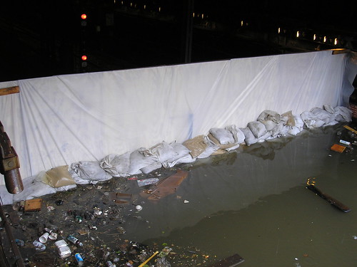
11:22 A.M. Effort to Drain Water From New York Train Tracks Begins
Our colleague Mike Grynbaum reports on Twitter that New York City’s Metropolitan Transportation Authority has defended the decision to shut the entire transit system down, explaining that subway trains and buses were removed from low-lying yards that are now flooded.
As Amy Davidson, an editor at The New Yorker, notes on her Twitter feed, the MTA just posted this photograph on its Flickr account of New York City Transit employees pumping water out of the Lenox Subway Yard at 148th Street in Harlem.
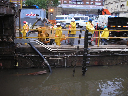
This photograph, also from the MTA Flickr account, shows workers constructing a “sea wall” at the yard in advance of the storm.
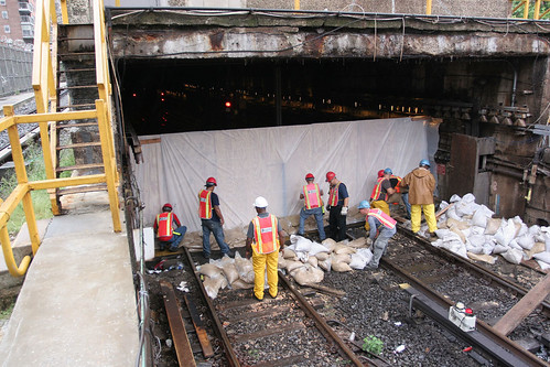
Here is an image of that improvised sea wall across the tracks on Sunday morning:
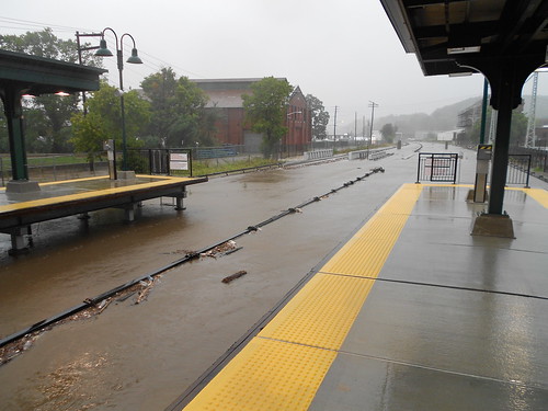
Further north here is an image of floodwaters from Sing Sing Creek covering the tracks — but not the third rail — of Metro-North Railroad’s Hudson Line at Ossining.
10:53 A.M. Power Failures in New York State
The official Twitter account of Governor Andrew M. Cuomo of New York just sent out an update on power failures in the state. There are 404,481 Long Island Power Authority customers without power. Con Edison, which serves much of New York City and Westchester County, has 102,783 customers out; National Grid has 71,870 customers out; Central Hudson Gas and Electric has 66,613; and the Orange and Rockland power company has 31,218, the update said.
Long Island Power Authority‘s own Web site, however, reported higher numbers. As of 10:49 a.m., it said that 441,237 customers were without power.
10:52 A.M. New Jersey Officials Urge Residents to Stay Inside
In an appearance on NBC on Sunday morning, Gov. Chris Christie of New Jersey urged residents of his state to remain inside. Mr. Christie stressed his concern about the dangers posed by downed power lines and “record flooding” in parts of the state — including Bound Brook, N.J., which was badly damaged in 1999 by Hurricane Floyd.
The governor posted this video of his interview with Matt Lauer on his YouTube channel about an hour ago:
Writing on his Twitter feed, Newark’s mayor, Cory Booker, reported about an hour ago: “We are up to 10 water rescues of motorists (& one dog) stranded on flooded roads. Please stay inside.”
In response to a question from another user of the social network who asked if he was really writing the updates himself, Mr. Booker told his followers: “I got bout 2hrs sleep & its really me wet and wired on caffeine.”
Replying to another user who posted a message noting that “we never had a hurricane,” during the previous mayor’s tenure, Mr. Booker wrote: “Lol, well I guess u can blame me then.”
10:25 A.M. Map Shows Latest Predicted Path of Tropical Storm
Here is an updated interactive map from the Google Crisis Response team charting the tropical storm’s predicted path, based on the National Hurricane Center’s latest forecast.
Governor Chris Christie said that most people on New Jersey’s barrier islands and coastal areas along the Jersey Shore heeded his call to evacuate. However, he remains concerned about the 600 mostly elderly residents who have been reluctant to leave their homes in about five or six high-rise apartment buildings in Atlantic City, our colleague Jennifer Preston reports.
“The best way to preserve human life on the Jersey shore is for there to be no human beings on the Jersey Shore, given what is about to come,” Mr. Christie said.
He also cautioned New Jersey residents to not let down their guard because Irene has been downgraded from a Category 2 storm to a Category 1. He anticipates extensive damage to private property and public infrastructure on barrier islands, and other parts of the coast, he said. The governor also warned that the 6 to 12 inches of expected rainfall could result in flooding conditions in towns miles from the coast, like Wayne, N.J.
People should have enough food and water to last five days, he said, because of the prospect of widespread and long-lasting power outages.
To help persuade the elderly residents in Atlantic City to leave, Mr. Christie said that state police officers have been sent to talk to residents, one by one, to try and persuade them to evacuate. NJ Transit buses have also been sent to wait out outside of the buildings, in hopes that people will choose to ride out the storm in emergency shelters instead of their apartments, he said. If the resident do stay, they risk injury from shattered glass and other damage from Hurricane Irene.
“I would ask you to please allow us to help you,” Mr. Christie said, looking directly into the television cameras during the briefing. “You are correct that I can not make you leave your home. But we really do have your safety first and foremost in our minds. Let us walk you downstairs and put you in one of those buses.”
Mr. Christie said that the evacuations from Long Beach Island and other areas along the coast from Sandy Hook to Cape May went smoothly and without major traffic delays. He said between 90 percent to 98 percent of residents in parts of Cape May, Atlantic, Ocean and Monmouth counties have departed.
More than 5,300 people are now being housed in emergency shelters, including on the campus of Rutgers University in New Brunswick, N.J. and at the Mennen Sports Center in Morristown, N.J. Another 1,200 people who were evacuated from Atlantic County on Friday spent last night without cots at the Sun National Bank Center, an arena in Trenton. Many people ended up sleeping in seats, he said. This group has since been moved to the Rutgers campus, which Mr. Christie visited following the press conference.
Other emergency shelters, if needed, would be set up at the Izod Center at the Meadowlands Sports Complex and at the National Guard armory in Jersey City, he said. To help state officials get the Meadowlands ready as an emergency shelter – and to keep people off the roads as the storm approaches – Mr. Christie said that he spoke yesterday with the owners of the Jets and the Giants about canceling today’s football games. They agreed.
For now, the governor said the southbound lanes of the Garden State Parkway, which were closed starting at Exit 98 on Friday, would not open anytime soon. He said that it was important to keep the roadway closed for emergency vehicles during and in the aftermath of the storm.
4:40 P.M. Mayor Bloomberg on Twitter: Zone A, Leave Now
About 20 minutes ago, Mayor Michael R. Bloomberg posted the below on his official Twitter account, urging people in the low-lying evacuation areas designated as “Zone A” to leave immediately.
If you live in Zone A, you need to evacuate NOW. Do not wait. Find maps, evacuation routes, and safety tips here: //t.co/xpvNE7j
 Mike Bloomberg
MikeBloomberg
4:07 P.M. Irenes Through the Years
This isn’t the first time we’ve met Hurricane Irene. In fact, a hurricane by that name has the potential to visit every six years because of the naming system employed by the World Meteorological Organization, an agency of the United Nations that gives the storms their monikers.
The last Irene was in August 2005, and according to NASA, “meandered aimlessly around the Atlantic Ocean for over two weeks, but even with her longevity, no reports of damages were associated with Irene.” Below is a video image posted on YouTube of that storm’s movements:
The 1999 version of Hurricane Irene hit the Bahamas, Cuba and Florida. Although it was considered a relatively weak storm, five people were electrocuted near Fort Lauderdale Fla., as as a result of the storm, and more than a million people in the state were left without power. President Bill Clinton declared an emergency at the time,
The Irene in 1981 did not make landfall in the United States, but bumped around the Atlantic in late September before stopping by France on Oct. 3, as a tropical storm.
In 1971 Hurricane Irene became something of a natural anomaly, being one of only a dozen Atlantic storms recorded to ever cross into the Pacific. That year, Atlantic Hurricane Irene sped westward, dipped south and passed over Nicaragua to enter the Pacific and became a tropical storm called Olivia.
The Irene of 1959 was just a tropical storm disturbing the edge of the Florida Panhandle.
3:54 P.M. Storm Kills an 11-Year-Old in Virginia
An 11-year-old boy was killed in Newport News, Va., on Saturday when a tree crashed through the roof a second-story apartment shortly after 12 p.m., emergency officials said.
The boy was in the apartment with his mother when the tree came down, pinning him underneath, according to a spokeswoman for the Newport News Emergency Operations Center. Officials had to call in a crane to lift the tree off of him. He was pronounced dead at the scene.
2:58 P.M. National Weather Service Issues Update on Irene
At 2 p.m. the National Weather Service’s National Hurricane Center issued the following update on the status and location of Hurricane Irene, excerpted in part below:
Irene is moving toward the North-Northeast near 13 miles per hour. A North-Northeastward motion at a slightly faster forward speed is expected during the next day or so. On the forecast track the center of Irene will move across Northeastern North Carolina this afternoon. The Hurricane is forecast to move near or over the Mid-Atlantic coast tonight and move over Southern New England on Sunday. Maximum sustained winds remain near 85 miles per hour with higher gusts.
Slight weakening is forecast as Irene crosses Eastern North Carolina but Irene is forecast to remain at or near hurricane strength as it moves near or over the Mid-Atlantic states and approaches New England.
2:09 P.M. Storm Kills 3 in North Carolina
Hurricane Irene only made landfall just a few hours ago, but the storm has already killed three people in North Carolina, according to the state’s Division of Emergency Management.
The first victim died of a heart attack on Friday while boarding up his home in preparation for the storm. The second victim was driving his car in Pitt County Saturday when it hydroplaned, ran off the shoulder and hit a tree. The third victim, a man in Nash County, stepped outside his home and was hit by a tree limb.
1:38 P.M. Power Could be Shut for Some Areas, But No Plans Yet
Mayor Michael R. Bloomberg spoke about possible responses that New York City agencies and utilities may have to the storm at a news conference at the New York Police Department’s 60th Precinct in Coney Island on Saturday. “It’s conceivable that in Downtown Manhattan, for example, there will be no electricity as well as a lot of water in the streets,” the mayor said.
On the City Room blog, my colleague Michael Grynbaum reports on the status of the city’s power:
Officials at Consolidated Edison said on Saturday they had no current plans for a pre-emptive shutdown of electrical power in parts of Manhattan. But the utility said its most vulnerable substations on the island, most of which are by the waterline in the Financial District, would be monitored for any severe flooding conditions.
If a shutdown of those substations did become necessary, the affected area would be the southeastern tip of Manhattan, bordered by the Brooklyn Bridge on the north, Broadway on the west and the East River on the south and east, said Chris Olert, a spokesman for Con Ed.
The below map shows the approximate area that would be affected. It was created based on the information provided by Mr. Olert.
View Approximate Area of New York City that would be Affected by a Potential Power Shutdown in a larger map
Mr. Olert said about 6,400 customers, including some large office buildings and multidwelling apartment houses, might potentially lose power in that scenario.
12:52 P.M. Hurricane Tracking Map by The New York Times
The New York Times has produced a hurricane tracking map that shows Irene’s progress in real time.
12:17 P.M. No Outstanding Requests for FEMA Assistance To Date
 Luis Alvarez/Associated PressHomeland Security Secretary Janet Napolitano, center, with W. Craig Fugate, the director of the Federal Emergency Management Agency, and American Red Cross chief executive Gail McGovern on Saturday.
As the storm began to move up the East Coast, Homeland Security Secretary Janet Napolitano said she knew of no outstanding requests to the federal government for assistance from state or local governments, my colleague Eric Lipton reports from a news conference Saturday morning at the headquarters of the Federal Emergency Management Agency in Washington.
“None of them have reported any unmet needs right now,” Ms. Napolitano said. “But we really are at the beginning of this storm response. We are basically at the end of the preparation phase”
Ms. Napolitano urged people along the path of the storm to heed warnings to evacuate, even though the storm continues to lose some of its intensity.
“Irene remains a large and dangerous storm,” she said. “People need to take it seriously. People need to be prepared.”
W. Craig Fugate, the FEMA director, said that the heavy rains and possible tornadoes that might accompany Hurricane Irene are not reflected in its Category 1 status, so people in its path should not put down their guard.
“Until we actually get the impacts, we are not going to know how bad areas are getting hit,” Mr. Fugate said.
Bill Read, the National Hurricane Center director, said that the storm as of Saturday morning was moving north/northeast at about 15 miles per hour and that he expected to see a storm surge along the coasts
of five and nine feet — more than enough to cause severe flooding. He said there could also be as much as 15 inches of rain in North Carolina before the storm clears and five to 10 inches of rain
across the Mid Atlantic and into New England, which could cause major flooding and tree damage, even inland, as the ground is already saturated, he said, from recent heavy rains.
11:25 A.M. Videos of the Storm in Progress Emerge
Dramatic home videos are emerging on social media as the hurricane thunders through the Southeast.
At about 11 a.m. a YouTube user named DaleMutro posted a video of the storm whipping the Ocracoke Lighthouse in North Carolina.
CNN has produced a compilation of videos of areas in North Carolina.
11:26 A.M. Google Maps Irene in a Multitude of Ways
Google’s Crisis Response division has created fascinating and functional map tools for tracking Hurricane Irene in multiple ways.
By clicking boxes to the right of the map on the Crisis Landing Web site users can add or subtract layers of information that are placed over a map of the East Coast like a film of tracing paper.
A particularly arresting image appears when the button “Cloud Imagery” is clicked. The image produced takes information from the United States Naval Research Laboratory and places it over Google’s own map.
It is also possible to produce a map showing the hurricane’s “Uncertainty Cone,” which is the area that shows the possible paths the eye of the storm could take.
The most functional of Google’s maps shows the Federal Emergency Management Agency‘s coastal evacuation routes. By zooming in or typing an address in the top left corner of the screen, it is even possible to see the FEMA route designated for individual areas.
Other useful map functions include identifying the locations of American Red Cross emergency shelters, and, as perhaps will be necessary after the storm, local power outages.
10:35 A.M. No Paywall for Hurricane Coverage
As a public service there will be no paywall on hurricane coverage in The New York Times, on the Web site, or on any mobile apps.
10:27 A.M. Pets May Ride in Taxis and Buses
Taxis and all buses must take pets as passengers it was announced.
Effective today at 9 a.m. “passengers must be allowed to travel with their household pets and service animals,” in taxis according to a release put out by the Taxi and Limousine Commission.
Cats, dogs and all other pets are permitted to ride on vehicles run by the Metropolitan Transportation Authority. Animals are generally permitted on mass transit, but with the exception of service animals, must ride in carriers. For the duration of Hurricane Irene, those rules have been relaxed.
Pets will be allowed on board M.T.A. vehicles. Dogs must be leashed and, if possible, should be muzzled. Cats and other pets should be in carriers.
According to the ASPCA, evacuation centers will be pet-friendly. The organization also has tips on disaster preparedness for pets.
10:09 A.M. Follow @NYTLive on Twitter for Latest on Irene

 Nicholas Kamm/Agence France-Presse — Getty ImagesA basketball hoop was blown over from the wind in Kill Devil Hills on Saturday.
Reporting from North Carolina, Brian Stelter writes that the eye wall of Hurricane Irene came ashore just east of Cape Lookout shortly after 7 a.m., the first stop in the mainland United States for a storm that is expected to scrape up the East Coast and bring flooding rains to a dozen states.
 Brian StelterDamage to a home in North Carolina.
From Nags Head, Brian writes that “radar images showed that the ragged eye of the storm appeared to reach land during the 7 a.m. hour. It is expected to force a storm surge into the bays and sounds here, inundating low-lying areas. An hour after dawn, the wide beach here in Nags Head had become a wide pool of water as waves began to erode the dunes of the Outer Banks.”
And that looks somewhat troublesome for New York. “Some weakening is expected after Irene reaches the coast of North Carolina,” the hurricane center said in its update, “but Irene is forecast to remain a hurricane as it moves near or over the mid-Atlantic states and New England.”
Updates from Brian can be found here.
8:10 City Changes Location of 4 Evacuation Sites
As the mandatory evacuations of the low-lying areas of New York continued Saturday morning, city emergency management officials made four changes to the locations of evacuations centers.
According the statement from the New York City Office of Emergency Management, the location changes included:
- The Evacuation Center marked on the NYC hurricane evacuation zone map as Aqueduct Racetrack, Rockaway Blvd. and 108th Street, Queens, is being replaced by John Adams High School, 101-01 Rockaway Blvd., Ozone Park, 11417.
- The Evacuation Center marked on the NYC hurricane evacuation zone map as Christ the King H.S. has been moved to Grover Cleveland H.S. Check the zone finder or call 311 for updated information.
- The Evacuation Center at JHS 57, 125 Stuyvesant Avenue, Brooklyn, is being closed. The center will be moved to PS26, 1010 Lafayette Avenue, Brooklyn.
- The Evacuation Center marked in the NYC hurricane evacuation zone map as HS of Graphic Communication Arts, 439 West 49 St., Manhattan, is being replaced by Park West High School, 525 West 50 St., Manhattan.
New York residents who live in the low-lying Zone “A” coastal areas across all five boroughs and the Rockaways are asked to be out of these areas by 5 p.m. Saturday. These areas include: Coney Island, Manhattan Beach, Far Rockaway, Beach Channel, South Beach, Midland Beach, and Battery Park City.
Zone A is clearly outlined in this interactive map posted online by WNYC. Earlier, the city decided to shut down the city’s entire subway and bus system at noon on Saturday.