I love a good road trip, especially in the mountains of Colorado, where I live. It’s when I do some of the best creative thinking, and it feels like the possibilities for exploration are endless. Should I hike a fourteener tomorrow? Cross the border into Utah to go mountain biking?
I scoured the globe to put together this list of the most stunning drives you could imagine, from the snowcapped peaks of Chilean Patagonia to the windswept west coast of Ireland. I’ve completed a handful, driven parts of many of them, and the rest are on my bucket list. I also chose these road trips for their proximity to adventure, and include essential details like the best hikes, beaches, and accommodations along the way. Buckle up.
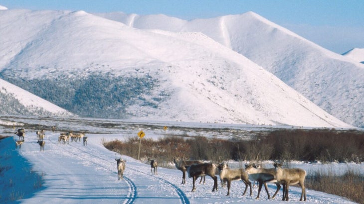
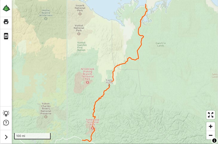
The Dempster Highway to the Arctic Ocean, Canada
Miles: 550
Road terrain: Mostly gravel
Best time to go: The Dempster Highway is open year-round, but traditional summer festivals in the Arctic towns and the aurora borealis viewing in winter are seasonal highlights.
Truly rugged and remote, this overland expedition traverses dramatic tundra landscapes, boreal forests, and mountain ranges en route to the Arctic Sea. Begin in the gold-rush outpost of Dawson City, Yukon, and load up on supplies—the unpaved gravel road is a known tire eater, so be sure you have a spare and a four-wheel drive car. From there the Dempster Highway heads north through the historic Klondike region, crosses the Arctic Circle, and enters the Northwest Territories, where you’ll have panoramas of what’s known as the polar Serengeti, a wide-open wilderness teeming with caribou, moose, and grizzlies.
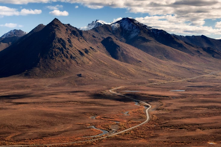
Along the way, you’ll pass through Indigenous communities such as Tsiigehtchic, reached by ferry in summer after the snow melts. If you’re traveling during August, you can watch canoe races and listen to traditional music during Tsiigehtchic’s Canoe Days celebration. By the time you arrive in Inuvik, Canada’s largest community north of the Arctic Circle, you’ll have logged 457 miles. Pitch your tent or park your teardrop at Happy Valley Territorial Park (from $28), perched on a bluff overlooking the Richardson Mountains and the nation’s largest river, the Mackenzie.
Pick up the final stretch of the trip in town, the Inuvik–Tuktoyaktuk Highway, an 86-mile gravel road that winds past the Pingo Canadian Landmark, a collection of pingo (mounds of earth-covered ice) more than 100 feet high, and ends in the Inuit shorefront hamlet of Tuktoyaktuk.
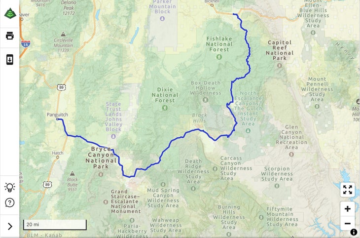
Scenic Byway 12, Utah
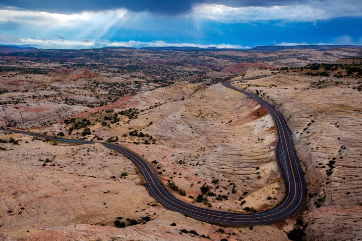
Miles: 122
Road terrain: Paved
Best time to go: Early spring and early fall
This expanse of highway connects Bryce Canyon to Capitol Reef National Parks, traveling through Dixie National Forest and the northern part of Grand Staircase–Escalante National Monument. The whole thing could be completed in three hours, but given its proximity to so many perfect playgrounds for hiking, paddling, biking, and fishing, I suggest a four-day road trip. Bookended by Panguitch to the west and Torrey to the east, this designated All-American Road bisects multiple ecosystems, from sage flats to slickrock deserts, and sleepy rural communities like Boulder, where you should stop for a meal at Hell’s Backbone Grill. The photo opps are endless, but Powell Point Vista, between the towns of Henrieville and Escalante, affords some of the best views of the area’s distinct Wasatch Limestone formations. If I could overnight in one place along the way it’d be Ofland Escalante, which has a drive-in theater, a pool, and a food truck (from $99).
The Romantic Road, Germany
Miles: 220
Road terrain: Paved
Best time to go: Spring or fall
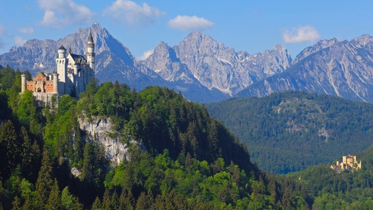
Germany’s Romantische Strasse, or Romantic Road, could be the backdrop of a Grimm’s fairy tale, with its turreted and crenelated castles, red-roofed villages, and lake-dotted countryside in the Alpine foothills. This scenic byway across Bavaria connects the baroque town of Würzburg with the pastel-hued town of Füssen. The former is home to the Unesco-designated Würzburg Residence, one of the nation’s most opulent palaces, while Füssen is five minutes from what many consider the route’s highlight, King Ludwig’s Neuschwanstein Castle, which was the inspiration for the palace in Disney’s Sleeping Beauty. If you want to stretch your legs, you can tackle the hike to Mount Tegel, located behind the castle, or take the cable car up and explore the trail network at the top.
Along the way you’ll pass plenty of beer gardens—the riverfront Lechgarten in the hamlet of Landsberg am Lech is a must-stop—the vineyards of the Franconia wine region (pick up a bottle of dry, white Silvaner), and spend a few hours rejuvenating in the historic spa town of Bad Mergentheim; at the Best Western Premier Parkhotel ($150), you can take advantage of the indoor pool, spa, and gardens.
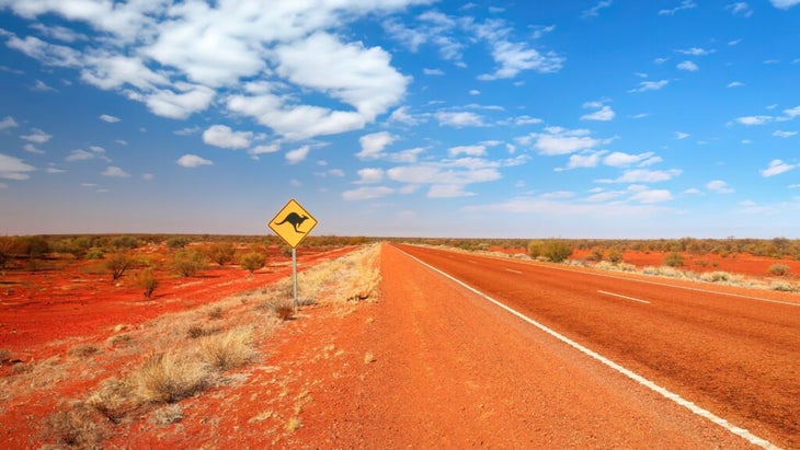
The Explorers Way, Australia
Miles: 1,864
Road terrain: Paved (and remember, Aussies drive on the left-hand side)
Best time to go: Australia’s fall, March through May
The ultimate outback odyssey, the Explorers Way is a road trip through Australia’s Red Centre. Much of the drive follows the Stuart Highway, named after 19th-century explorer John McDouall Stuart, the first European to successfully traverse the continent from south to north. Stuart’s expedition took nearly a year, but two weeks is ample time to complete the journey from Adelaide in South Australia to Darwin in the Northern Territory.
I highly recommend detours to Uluru–Kata Tjuta National Park to stand in awe of the 2,831-foot-high monolith sacred to Aboriginals and to Litchfield National Park, teeming with waterfalls and wildlife like dingo and wallaby. Dedicate at least a day to explore the Aboriginal art galleries of Alice Springs, the Northern Territory’s second largest city and the approximate midway point of the route. When you reach the Top End, toast your trip with a bush negroni at Willing Distillery in Darwin or celebrate with a bush safari at Bamurru Plains Eco Lodge (from $2,425, all-inclusive), just northwest of Kakadu National Park, home to more than two dozen walking trails.
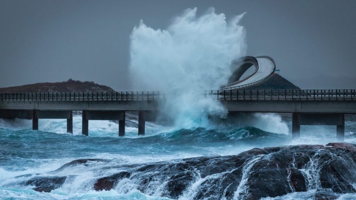
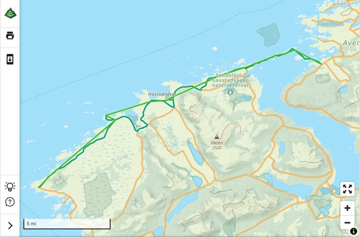
Atlantic Road, Norway
Miles: 22
Road terrain: Narrow, paved
Best time to go: The coast is most dramatic in September and October
Norway has 18 designated national scenic routes, but the fact that the Atlantic Road was selected as the stage for the James Bond film No Time to Die is a testament to its wow-factor beauty. Officially known as Atlanterhavsvegen, this drive links the village of Kårvåg on Averøy Island with the fishing village of Bud on the mainland via an archipelago connected by eight low-lying bridges. Few roads bring you so close to the ocean: roll down your window and you’ll likely be kissed by sea mist.
Essential detours include the coastal path at Vevang to see Jan Freuchen’s “Columna Transatlantica,” a sculpture scattered across the rocks and heath-covered hills, and the glass-walled viewing platform at Askevågen, which affords spectacular mountain and ocean vistas. Strømsholmen Seasport, located between the towns of Kristiansun and Molde, offers scuba diving, fishing excursions, and wildlife safaris on the water. It also has four waterfront cabins that sleep up to ten people (from $55).
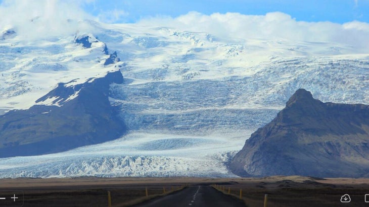
The Ring Road, Iceland
Miles: 820
Road terrain: Mostly paved, with some stretches of gravel
Best time to go: Late spring or early fall
Stretch after stretch of otherworldly landscapes unfold along this famed 820-mile loop, also known as Route 1. It shows off vast lava fields, tumbling waterfalls, spouting glaciers, and bubbling geysers. You’ll want at least seven days to enjoy all the attractions and adventures along the way, and if you do the drive in May, June, or July, you can take advantage of nearly 24 hours of sun.
Most road-trippers start in the capital, Reykjavík, the city closest to Keflavík International Airport. You can tackle it counterclockwise or clockwise, but if you do the latter first, the scenery crescendos from pretty to jaw-droppingly gorgeous. If there’s one thing you shouldn’t miss, it’s a detour to the northern Troll Peninsula, which loops around the headlands past the end of the Skagafjörður fjord.
On the southeastern coast of Iceland, take time to explore Jökulsárlón, a glacial lagoon studded with icebergs, and nearby Diamond Beach, named for the brilliant chunks of ice that sparkle like gems against its black sands. The geothermal waters of the Blue Lagoon, just 20 minutes from the airport, are the perfect final stop. Or tack on an adventure—maybe kayak in a glacial lagoon or ride an ATV along the beach—with outfitter Icelandic Mountain Guides.
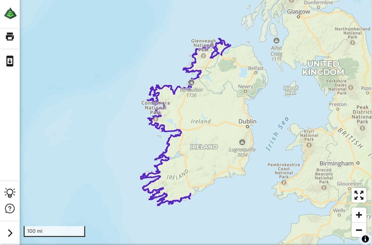
Wild Atlantic Way, Ireland
Miles: 1,600
Road terrain: Narrow, winding, and paved (you’ll also driving on the left-hand side here)
Best time to go: summer to take advantage of longer day-light hours
One of the longest coastal routes in the world, the Wild Atlantic Way hugs the Emerald Isle’s rugged and spectacular west coast for miles, from its northern terminus on the Inishowen Peninsula in County Donegal to its southern terminus in the town of Kinsale in County Cork. The route is broken into 14 stages, and you’ll want to budget a minimum of five days to complete it.
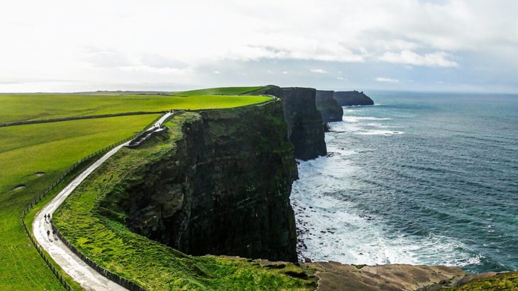
There are loads of opportunities to stretch your legs on untouched swaths of beach near soaring sea cliffs. Those at Slieve League jut up 1,972 feet at their highest point; follow the Pilgrim’s Path from Teelin village 1.5 miles to the tops, and after pop into town for lunch. You’ll have plenty of options, but I highly recommend the award-winning Rusty Mackerel pub (rooms are also available from $54). The iconic Cliffs of Moher, in the lunar-like Burren region, are one of the natural treasures of Ireland, with a five-mile (one-way) coastal walk that connects the charming villages of Liscannor and Doolin.
On Achill Island, explore Keel Beach, a nearly two-mile stretch of golden sand. When I visited, the waves were pumping and I rented a board and a thick wetsuit from Soundwave Surf School. If the water’s calm, you can rent a stand-up-paddleboard. If your final destination is County Cork, celebrate with a pint at Levis Corner House, a pub in Ballydehob that’s been run by the same family for a century.
Pacific Coast Scenic Byway, Oregon
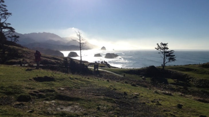
Miles: 363
Road terrain: Paved
Best time to go: Late spring, early fall, or winter
Most people associate the Pacific Coast Highway, or PCH, with California, but the storied road spans from Canada to Mexico. Some of the best lengths, in my opinion, are in Oregon, where the road skirts virgin beaches, craggy mountains, and rocky coves, through a series of quirky seaside resorts and sleepy fishing villages. You could zip along all of it in 10 to 12 hours, but five days is the better plan, stopping at the many parks and public lands along the route. Ecola State Park (sea stacks, tidepooling, wildlife-watching) and Oregon Dunes Recreation Area (whose sweeping sandy expanses are said to have been the inspiration for Dune’s planet Arrakis) are both top of my list.
About 30 miles northwest of the city of Bandon is Cape Arago; this short detour off the byway takes you through the South Slough National Estuarine Reserve, home to more than 150 kinds of birds and many good hiking trails. In the town of Coos Bay, I like to overnight at the modern cabins at Bay Point Landing ($235). The next day, you can drive 24 miles east to the remote Golden and Silver Falls State Natural Area and hike 1.4 miles to the top of Golden Falls for an eagle’s-eye view of the cascading waterfall and old-growth firs. Schedule your journey for spring and winter and bring your binocs—you can often spot the blows from migrating gray whales as they surface off the coast.
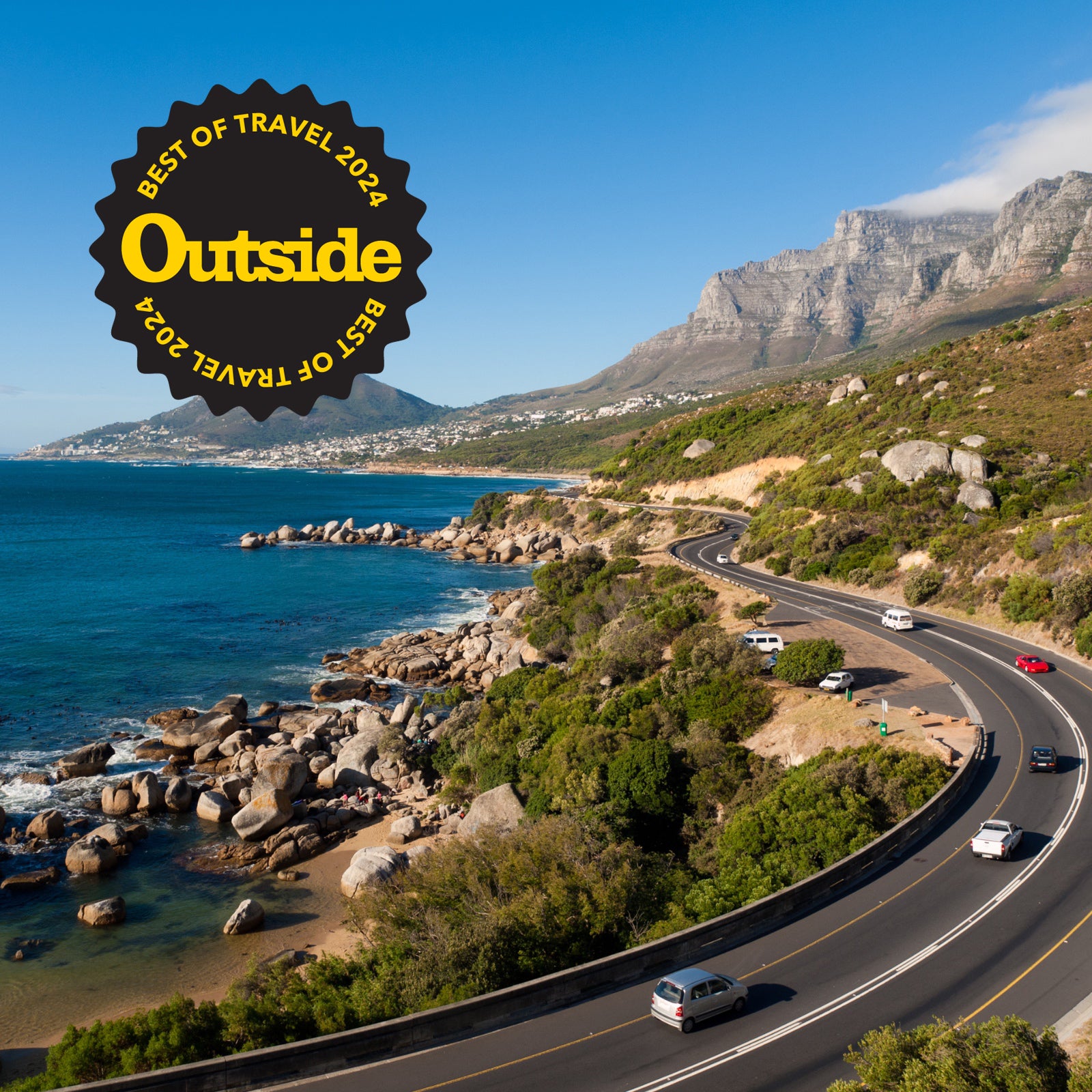
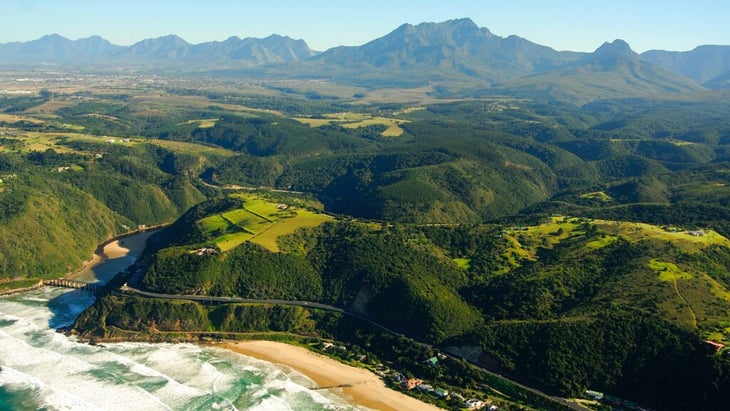
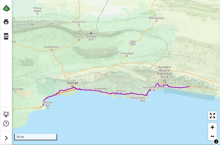
The Garden Route, South Africa
Miles: 124
Road terrain: Paved
Best time to go: June to December, when you can spot whales from shore
This ocean-hugging highway showcases the Western Cape’s outrageously beautiful beaches, lush forests, national forests, and abundant marine life. Just under two hours’ drive from Cape Town, the former fishing village of Hermanus Bay is the gateway for the Garden Route. I always stop here to take advantage of the excellent land-based whale-watching between June and December. Continue three and a half hours east on the N2 highway to the harbor town of Mossel Bay, the route’s official starting point. Spend some time trekking around before heading out on your drive; my favorite is the 2.5-mile out-and-back trail from Pinnacle Point to Oyster Bay.
Wilderness National Park, approximately midroute, is a great spot for birdwatching and kayaking and has accommodations that include campsites (from $20), cabins (from $50), and a bed-and-breakfast (from $90). A half-hour farther east is Plettenberg Bay, nicknamed the Saint Tropez of South Africa for its palatial beach homes. Just south is Robberg Nature Reserve, a nice picnic spot where you can observe seal colonies. Spend a day exploring Tsitsikamma National Park, which boasts a 50-mile-long shoreline and an interior with 500-year-old trees. Looking to burn off some energy after hours in the car? I suggest the Otter Trail. South Africa’s oldest hiking trail takes five days to complete and begins near the Garden Route’s eastern terminus at Storms River rest camp.
Queenstown to Milford Sound, New Zealand
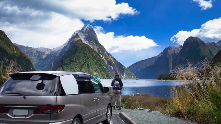
Miles: 180
Road terrain: Paved, two-lane highway
Best time to go: New Zealand’s fall, March through May, is perfect for hiking
Described by Rudyard Kipling as the “eighth wonder of the world,” Milford Sound is big nature on steroids. The drive on the South Island from Queenstown along State Highway 6 (a.k.a. the Southern Scenic Highway) and then State Highway 94 (Milford Sound Highway) will get you there in just over four hours, but slow down to marvel at the waterfalls and alpine lakes framed by mountains. Te Anau is the halfway point of the drive and an ideal place to overnight, refuel, and stock up on food as there are no services farther en route to the sound. The lakeside town is also the gateway to the glacier-carved wilderness of Fiordland National Park and the jumping-off point for the Milford Track, arguably one of New Zealand’s most famous Great Walks, so consider tacking on a few extra days.
The Carretera Austral, Chile
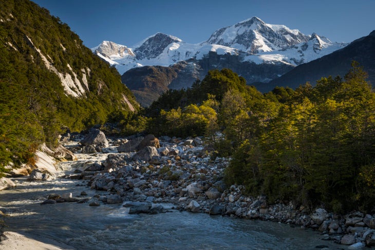
Miles: 770
Road terrain: Rugged, pock-marked dirt, requiring four-wheel drive
Best time to go: Austral spring and summer, November to March
Waterfalls tumbling from hanging glaciers. Forests of lengua trees and turquoise lagoons. Ancient marble caves and flamingo-filled lakes. The wild backdrop of Chile’s Southern Highway (Route 7) is an adventurer’s fantasy. Also known as the Carretera Austral, this road cuts through remote, mountainous wilderness in northern Patagonia. Set aside at least two weeks so you can take time to visit Queulat National Park and Pumalín National Park, both located along the route.
Puerto Montt, a bustling town in the Chilean Lake District, is your starting point. It’s considered Chile’s seafood capital, so attempt to score a table at Pa Mar Adentro Restaurant and try the caldo curanto, a traditional seafood stew, before starting your journey south.
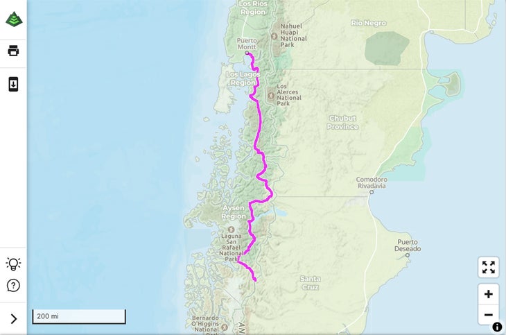
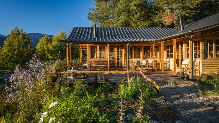
Coyhaique, the capital of Chile’s Aysén region, marks the route’s midway point. Take a day here to trek the trails of Reserva Nacional Coyhaique, home to two beautiful lakes, Los Sapos and Venus. Campsites are available in the Casa Bruja section of the reserve ($5), or continue a couple hours south to General Carrera Lake and hole up at the family-run Mallin Colorado Ecolodge ($170). The owners serve terrific farm-to-table meals and partner with local guides who lead kayak trips to the Marble Caves and treks across Exploradores Glacier.
Rumbo Sur Hotel ($190), in the isolated terminus town of Villa O’Higgins, is a comfy final base surrounded by hiking trails and glaciers. A 4×4 is recommended, as most of the road is unpaved.
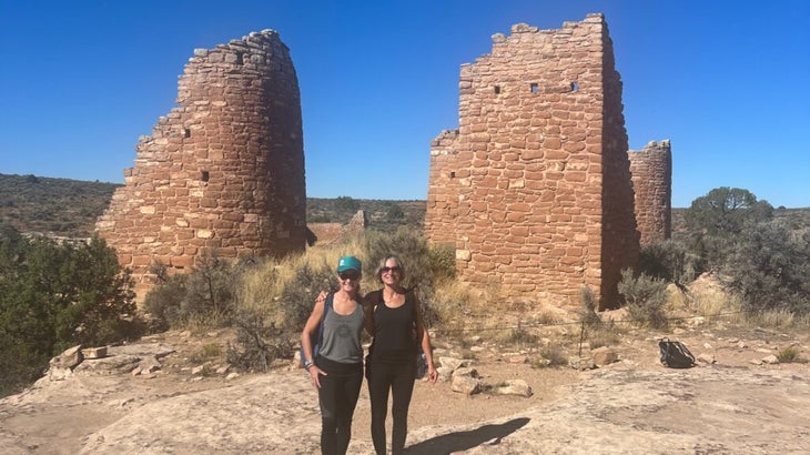
Outside travel columnist Jen Murphy hates driving but will happily sit shotgun on any road trip. Last fall she navigated on a weeklong mother-daughter road trip through southwest Colorado.