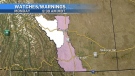
Heavy, wet snow blankets Calgary, warmup not expected until Sunday
As expected, a frontal system brought rain to southern Alberta, then heavy, wet snow into the region late Monday and early Tuesday.
An embedded low settled around the Calgary area, and with an atmospheric temperature profile around freezing, the early snow was very dense with water-packed around the snowflake nuclei.
Unusually warm weekend conditions allowed surfaces like roadways to retain enough heat that initial snow melted on roads while it collected on natural surfaces and vehicles.
 This system will track east throughout the day Tuesday, with the leading edge still warm enough that the precipitation will be rain, before the colder air mass behind it drops the temperature.
North winds will remain strong on Tuesday and Wednesday at around 20 to 40 kilometres per hour.
Temperatures are also expected to remain well below seasonal until the end of the week, with daytime highs between nine and 11 C below average until Friday.
Another strong ridge of high pressure will move in by the end of the weekend, at the same time a polar air mass will sink south over parts of eastern Canada.


CTVNews.ca Top Stories

DEVELOPING
DEVELOPING 'Numerous' officers shot in 'active situation' in Charlotte, North Carolina, police say
'Numerous law enforcement officers' have been shot in an “active situation” in Charlotte, North Carolina, police say.
Toronto police arrest 12 people, lay 102 charges in major credit card fraud scheme
Toronto police say 12 people are facing a combined 102 charges in connection with an investigation into a major credit fraud scheme.
B.C. premier says Vancouver speech praising Hamas attack was 'most hateful' he can imagine
B.C. Premier David Eby has joined other politicians denouncing remarks at a demonstration in Vancouver where protesters chanted “long live Oct. 7,” praising that day's attacks by Hamas on Israel.
International students will be allowed to work 24 hours a week starting in September
Immigration Minister Marc Miller says international students will be able to work off-campus for up to 24 hours per week starting in September.
MPs targeted by Chinese hackers question why Canada didn't tell them
Members of Parliament are questioning why Canadian security officials did not inform them that they had been the target of Beijing-linked hackers, after learning from the FBI that the international parliamentary alliance they are a part of was in the crosshairs of the Chinese cyberattack in 2021.
Norovirus spreading at 'higher frequency' than expected in Canada
Norovirus is spreading at a 'higher frequency' than expected in Canada, specifically, in Ontario and Alberta, according to the Public Health Agency of Canada.
Less alcohol, or none at all, is one path to better health
Moderate drinking was once thought to have benefits for the heart, but better research methods have thrown cold water on that.
In a world first, king-size cigarettes in Canada must feature one of these warnings starting Tuesday
Tobacco manufacturers have until Tuesday to ensure every king-size cigarette produced for sale in Canada has a health warning printed directly on it.
WATCH
WATCH So you haven't filed your taxes yet…
The clock is ticking ahead of the deadline to file a 2023 income tax return. A personal finance expert explains why you should get them done -- even if you owe more than you can pay.
Shopping Trends
The Shopping Trends team is independent of the journalists at CTV News. We may earn a commission when you use our links to shop. Read about us.


Edmonton
-
Company ordered to pay $360K in 2022 death of central Alberta worker
An oilfield equipment supply company has been ordered to pay $360,000 in connection with the death of a worker more than two years ago.
-
Trans Mountain pipeline project ushers in new era for oilsands hub Fort McMurray
As the urban centre at the heart of Canada's oilsands industry, Fort McMurray has seen more than its share of ups and downs.
-
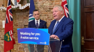
Premier Danielle Smith to announce update to passenger rail service
Premier Danielle Smith will be in Calgary on Monday to announce more details about a plan to improve rail service in Alberta.
Lethbridge
-
RCMP in Coaldale, Alta., area conduct check stops, pull over more than 200 vehicles
Three locations, more than 200 vehicles pulled over – Mounties out of a southern Alberta detachment conducted a check stop operation on Friday night.
-
Bandits get hat trick from Logan Sawyer en route to 8-2 win over Okotoks
The Brooks Bandits got down to business Friday, defeating the Okotoks Oilers 8-2.
-
'No real winner' following first Alberta NDP leadership debate: political scientist
An Alberta political scientist said the NDP leadership hopefuls remained fairly even following the first of the party’s debates.
Vancouver
-
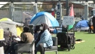
Pro-Palestinian protest encampment established at UBC
Pro-Palestinian protesters have established an encampment at the University of British Columbia in Vancouver in solidarity with the people of Gaza amid the ongoing Israel-Hamas war.
-
RCMP bullying claims in Surrey policing case could cause 'undue' concern, lawyer says
A B.C. government lawyer says court documents in a policing dispute with the City of Surrey contain significant allegations of harassment and bullying by the RCMP that should be kept from public view because they could cause “undue public concern.”
-
B.C. premier says Vancouver speech praising Hamas attack was 'most hateful' he can imagine
B.C. Premier David Eby has joined other politicians denouncing remarks at a demonstration in Vancouver where protesters chanted “long live Oct. 7,” praising that day's attacks by Hamas on Israel.
Vancouver Island
-

London Drugs stores remain closed Monday after 'cybersecurity incident'
Dozens of London Drugs stores across Western Canada remained closed Monday following what the company described as a "cybersecurity incident" over the weekend.
-
Pro-Palestinian protest encampment established at UBC
Pro-Palestinian protesters have established an encampment at the University of British Columbia in Vancouver in solidarity with the people of Gaza amid the ongoing Israel-Hamas war.
-
Historic church in Vancouver for sale for $10M
A nearly century-old church in one of Vancouver's most desirable neighbourhoods is up for sale.
Saskatoon
-
Saskatoon man stabbed in incident of intimate partner violence, police say
A 27-year-old Saskatoon man is facing assault charges following a report of intimate partner violence on Saturday.
-
Kindersley, Sask. man facing drunk driving charges after fatal crash with cyclist
A 20-year-old Kindersley man faces multiple charges for impaired driving and failing to stop at the scene of a fatal crash that led to the death of a 21-year-old man in the town west of Saskatoon early Saturday morning.
-
Saskatoon Public Schools says budget increase won't cover growing enrollment or class complexity
Saskatoon’s public school board says that despite “record” funding from the province this year, the ministry’s allocation to the division doesn’t make the grade.
Regina
-

USask study highlights more concerns with proposed Bunge-Viterra merger
Several western Canadian organizations representing producers have joined the fray in expressing their concerns over the proposed merger of Regina based Viterra with the Swiss-founded company Bunge.
-
Kindersley, Sask. man facing drunk driving charges after fatal crash with cyclist
A 20-year-old Kindersley man faces multiple charges for impaired driving and failing to stop at the scene of a fatal crash that led to the death of a 21-year-old man in the town west of Saskatoon early Saturday morning.
-
Saskatchewan highlights preparations made ahead of wildfire season
Saskatchewan has brought in resources early to prepare for this year's fire season. A drier than normal summer is forecast with eleven fires currently active.
Toronto
-

'Don't use the phones': Ford tells Ontario's students
Ontario Premier Doug Ford says the province's latest attempts to limit cellphone use in classrooms are designed to help students focus on learning.
-
Toronto police arrest 12 people, lay 102 charges in major credit card fraud scheme
Toronto police say 12 people are facing a combined 102 charges in connection with an investigation into a major credit fraud scheme.
-
Norovirus spreading at 'higher frequency' than expected in Canada
Norovirus is spreading at a 'higher frequency' than expected in Canada, specifically, in Ontario and Alberta, according to the Public Health Agency of Canada.
Montreal
-
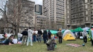
McGill University says pro-Palestinian demonstrators 'refuse' to collaborate, encampment violates policies
McGill University says the growing encampment on its lower field in solidarity with Palestinians in Gaza violates its policies.
-
Recycle your wine bottles and watch them transform into bridges, sidewalks
In a time of push for bigger and better infrastructure, Quebec researchers are working toward an environmentally friendly way to build bridges and construct sidewalks.
-
5-alarm fire forces evacuation of Montreal home for women at risk
Montreal firefighters are battling a blaze that has turned into a five-alarm fire in the Rosemont-La-Petite-Patrie borough.
Atlantic
-

Third youth charged with second-degree murder in death of 16-year-old: Halifax police
Police have charged a third youth in connection with the death of a teenager in Halifax last week.
-
Bedford man charged with stunting after vehicle clocked at 248 km/h: N.S. RCMP
A Bedford, N.S., man has been charged with stunting after the RCMP says he was caught driving more than 138 km/h over the posted speed limit.
-
Police investigating alleged threats at 2 Halifax high schools
A high school in Halifax is dismissing students early Monday due to an alleged threat.
Winnipeg
-

Winnipeg trial of man accused of killing four women starts with bid to toss jury
The trial of a Winnipeg man accused of killing four women began this morning with a preliminary matter before the jury is called in next week.
-
A timeline of the Jeremy Skibicki case
The trial for the man accused of killing four Indigenous women in Winnipeg is set to get underway on April 29.
-
Jets forward Vladislav Namestnikov suffers a fractured cheekbone after a puck hit him in the face
Winnipeg forward Vladislav Namestnikov suffered a fractured cheekbone when a puck hit him on the left side of his face in Game 4 against Colorado, the team said Monday.
Ottawa
-
Province to open new 'regional office' in Ottawa
Premier Doug Ford announced the province will be opening a new regional office dedicated to Ottawa on Monday.
-
One woman's story about the damage fraudulent links can do
An Ottawa woman says she believes clicking on a fraudulent link led to her entire bank account being compromised, leaving her out thousands of dollars.
-
Via Rail unveils new early morning train service between Toronto, Ottawa
Via Rail says it will be operating an early-morning train service between Ottawa and Toronto for commuters hoping to arrive before 9 a.m.
Northern Ontario
-
Former child protection worker in northern Ont. charged with sexual assault
Police in Greater Sudbury have charged a 57-year-old Sudbury suspect with sexual assault in a case that dates back 25 years.
-
Human skeletal remains found in Chelmsford area of Greater Sudbury, police say
A gruesome discovery was made in a remote wooded area of Greater Sudbury on Sunday night, Sudbury police say.
-
One taken to hospital after car flips over in Sudbury
One person has been taken to hospital with unknown injuries following a collision on Notre Dame Avenue in Sudbury on Monday.
Barrie
-
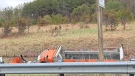
Dump truck rollover closes northbound Highway 400 lanes
Police say the Highway 400's northbound lanes are still closed after the crash early Monday.
-
Barrie police seek alleged car-bombing suspect
An alleged suspect has been identified by police for a car-bombing incident in Barrie last fall.
-
Sentencing hearing adjourned for teen murderer
The adjourned sentencing hearing was set to begin for the third of three young men who have pleaded guilty to their involvement in the murder of a 17-year-old Barrie boy outside his home in late 2021.
Kitchener
-

Ont. government announces new rules for cellphones in schools
Ontario Premier Doug Ford says the province's latest attempts to limit cellphone use in classrooms are designed to help students focus on learning.
-
Threat investigation prompts hold and secure at Fergus schools
Two Fergus schools were placed in hold and secure Monday while Ontario Provincial Police investigated a potential threat.
-
International students will be allowed to work 24 hours a week starting in September
Immigration Minister Marc Miller says international students will be able to work off-campus for up to 24 hours per week starting in September.
London
-
Arson charge laid after fire set outside downtown London, Ont. residence
A woman is in police custody after allegedly setting a fire outside a home in the city’s core late last week.
-
London man charged with sexual assault following alleged downtown incident
Police have charged a 20-year-old London man with sexual assault following an alleged incident downtown.
-
$418 million for South Bruce to host nuclear waste project
If the Municipality of South Bruce permanently houses Canada’s used nuclear fuel, it will be paid $418 million over the next 138 years to do so.
Windsor
-
Motorcycle driver dead after crash with car on Dougall Avenue
A 19-year-old motorcycle driver has died after being struck by a car on Sunday evening. Around 8:30 p.m., police responded to the crash in the southbound lanes of Dougall Avenue near the E.C. Row Expressway.
-
Sentencing delayed for Windsor denturist convicted of sex offences
Sentencing has been delayed for a Windsor denturist convicted of sex offences.
-
Two weekend fires under investigation
Windsor fire and police are investigating two fires over the weekend.


