


April's first full weekend brings a large spring snow storm to Colorado for Saturday and Sunday after four or five days of warm and dry conditions in the state's mountains.

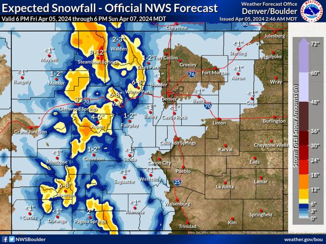
Expected snowfall totals from April 5 to 7, 2024 for Colorado from a spring snow storm.
More snow returns mid-week to the northern mountains before a warm up statewide starting Thursday.
Recap:
On Friday, clear blue skies started the day, however, high level clouds began moving into the state mid-afternoon from the west. It was also rather warm in Colorado's mountains, with a temperature of 51 degrees at 3:30 p.m., at Wolf Creek Ski area showing on the dashboard thermometer.
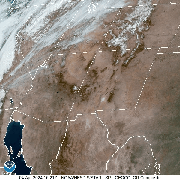
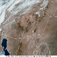
Snow cover is shown across the southern Rocky Mountain states between 10:21 p.m., Wednesday to 6:16 a.m., Friday.
Forecast:
On Friday night winter is back, with the storm system focusing on the western side of the state, bringing snow both Saturday and Sunday.

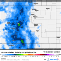
A Weather.us forecast map from the ECMWF model shows the potential total accumulation levels of water-equivalent precipitation as of 9 a.m., Saturday, April 6 for Colorado. Depending on the density of the snow, one inch of water is equivalent to 10 inches of snow based on a common rule of thumb ratio of 10:1.
The ECMWF high resolution model from Thursday evening forecasts snow totals between 4-12 inches for the southern, western and central mountains, and 4-8 inches in the northern mountains by Saturday morning.
Additional snow accumulations of between 4-8 inches in the southern, western and central mountains and between 3-6 inches in the northern mountains for Sunday's first chairs are forecast.

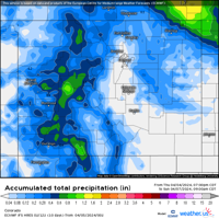
A Weather.us forecast map from the ECMWF model shows the potential total accumulation levels of water-equivalent precipitation as of 9 a.m., Sunday, April 7 for Colorado. Depending on the density of the snow, one inch of water is equivalent to 10 inches of snow based on a common rule of thumb ratio of 10:1.
The storm's track comes into the state from the south southwest Friday late morning, with snow starting in the southern and far-western mountains in the afternoon.
The low pressure responsible for the snow moved onto the California coast near San Francisco on Thursday and will push southeastward toward Las Vegas, Nevada and the Arizona desert, pumping moisture into Colorado for the better part of 36 hours.
The heaviest snow accumulations will be farther north into Montana and Idaho, however, upsloping winds will give the eastern and southeastern mountains snow into Sunday morning, with accumulations between 1-3 inches in the eastern mountains and 3-6 and up to 8 inches in the southeastern mountains.
On Monday, dry and sunny conditions are forecast ahead of the mid-week storm Tuesday and Wednesday.
Long Range:
On Tuesday, a fast moving system will bring snow, starting in the afternoon, to the northern and eastern mountains with potential accumulations between 4-8 inches for Wednesday's first chairs. Between 2-5 inches of snow is possible in the central and southern mountains for Wednesday's first chairs.
From Wednesday to Saturday, sunny skies and drying out build back in ahead of a weak storm for Saturday night into Sunday.
Today's 24 hour snow totals from Colorado resorts:
Arapahoe Basin - 0"
Aspen Mountain - 0"
Aspen Highlands - 0"
Beaver Creek - 0"
Breckenridge - 0"
Buttermilk - Closed for season
Cooper - 0"
Copper Mountain - 0"
Crested Butte - 0"
Echo Mountain - 0"
Eldora Mountain - 0"
Granby Ranch - Closed for season
Hesperus - Closed for season
Howelsen Hill - Closed for season
Kendall Mountain - Closed for season
Keystone - 0"
Loveland - 0"
Monarch - 0"
Powderhorn - 0"
Purgatory - 0"
Silverton - 0"
Snowmass - 0"
Steamboat - 0"
Sunlight - 0"
Telluride - 0"
Vail - 0"
Winter Park - 0"
Wolf Creek - 0"


 Your Privacy Choices