


LOUISVILLE, Ky. (WDRB) -- A possible tornado that started in southern Indiana and moved over to Kentucky left damage to homes, trees uprooted, and power lines down Tuesday evening.
WDRB's weather team confirmed a tornado on the ground in Oldham County, Kentucky, Tuesday evening around 5:30 p.m.
The possible tornado started in eastern Jeffersonville, Indiana, and moved across the Ohio River into the Prospect and Goshen areas.
WDRB's Marc Weinberg said a tornado had hit Prospect. Oldham County's emergency management said an "extremely dangerous tornado" was moving into the county just before 6 p.m.
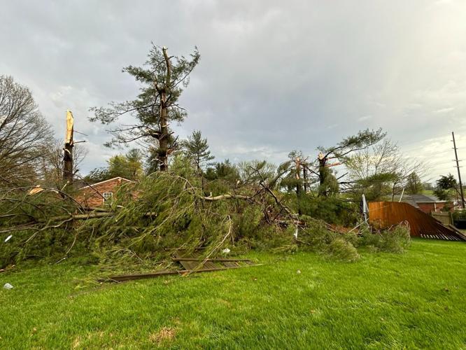
Prospect, Kentucky, Mayor Doug Farnsley said there were about 4-5 houses damaged in the city, with a lot of trees down and power outages.
We’re on River Road making our way toward Prospect. Already seen one tree down @WDRBNews pic.twitter.com/LLz2FLr1xl
— Conroy Delouche (@ConroyDelouche) April 2, 2024
Trees and power lines were reportedly down along U.S. 42 into Oldham County in Prospect. There were also reports of stoplights being out and the intersection of U.S. 42 at Boy Scout Road, near the Jefferson and Oldham county line, being blocked, according to a WDRB News viewer.
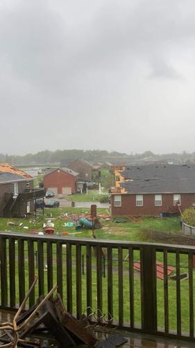
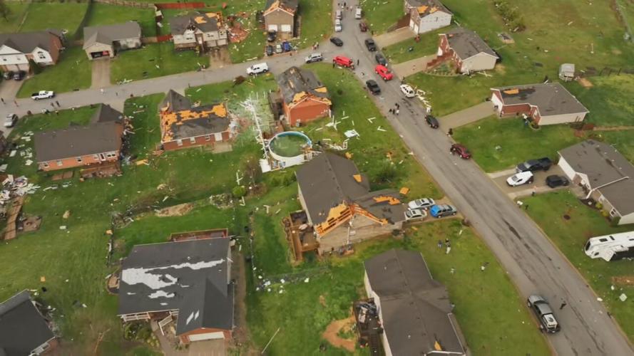
Kevin Parker, assistant chief of South Oldham Fire, said damage is widespread throughout Oldham County. A neighborhood in Buckner had at least six homes damaged on one street, according to Parker.
"I would say this is considered moderate damage, we don't normally have tornadoes in Oldham County, but when we do it's pretty significant to us," Parker said. "We had some homeowners who were distraught when we arrived on scene."
Parker said there were no reported injuries. Crews have contacted the Red Cross for people displaced from the storms.
A majority of Buckner, which is in Oldham County, is without power. While the storm tore through the town quickly, it left thousands of dollars in damage behind.
A majority of Buckner, which is in Oldham County, is without power. While the storm tore through the town quickly, it left thousands of dollars in damage behind.
Matt, a homeowner who talked to WDRB's Conroy Delouche, said the powerful winds were like a freight train as they blew over his home, which was damaged.
"We were all just hanging out in the house, got the notification and headed into the basement," he said. "And we were down watching the news, heard the report of a train then several loud booms, it was over in seconds."
Matt said they only had about three minutes to spare once they got to the basement. When they got back upstairs, they were stunned at the amount of damage left behind not just to their home, but for others on their block. He said they do have family and places to go in the area while they figure out their next move.
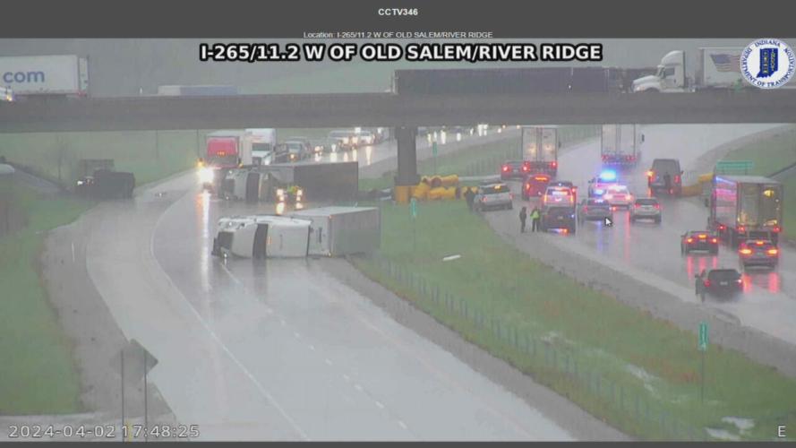
Multiple vehicles flipped over from high winds or possible tornado on I 265 westbound near the Lewis and Clark Bridge. Police on scene. pic.twitter.com/79AL56D2Mi
— Sgt. Carey Huls (@ISPSellersburg) April 2, 2024
Back in southern Indiana, at least three semitrucks were turned over in Jeffersonville on Interstate 265, under the overpass for International Drive in the Utica area. Indiana State Police Sgt. Carey Huls said multiple vehicles flipped over from high winds near Lewis and Clark Bridge.
Jeffersonville Mayor Mike Moore said a fourth semi had turned over not far from those three. One car was trapped underneath one of the semis, and Moore said that person is OK.
"When you see a site like that, that is pretty graphic and pretty scary," he said. "I swallowed my tongue when I saw the video on the news and when Marc Weinberg pointed out the car underneath the semi, I thought, there's no way that person survived. And I thank God that person walked away."
In total, Jeffersonville is reporting 10 people were injured during the storms on Tuesday. Jeffersonville Police said the injuries were "minor."
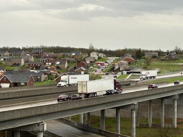
Storm damage was being reported Tuesday evening in the Crystal Springs subdivision in Jeffersonville, Indiana. That's off New Chapel Lane, north of the roundabout. Much of the damage is concentrated in northeast Jeffersonville.
The video comes from Ethan Williams, who captured Tuesday's storm while on International Drive, above Interstate 265.
Moore told WDRB News that crews are responding to storm damage in several neighborhoods in the southern Indiana city.
"The neighborhoods on the east end of the city got walloped pretty good," he said. "We're going to make sure things are cleaned up and safe, but I would not encourage anyone to get out in their car and drive around."
Moore said several neighborhoods near River Ridge and the east end bridge — the "fastest-growing residential area in the city" — were "hit hard." He also said the city will have sites set up soon for residents to dispose of any debris from the storm damage.
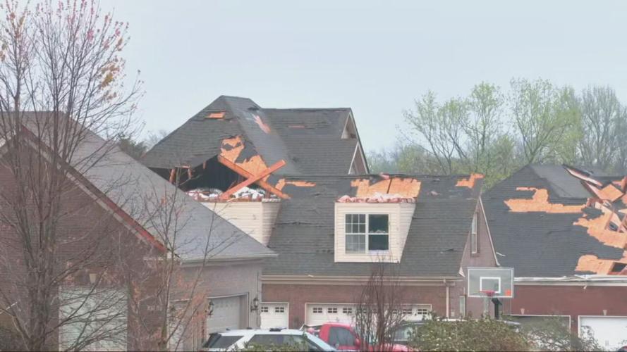
Several homes were damaged along Chelsea Meadow Court, on one side of the street. Roofs were ripped open, gutters were left twisted, but fortunately there were no major injuries. Many of those left with damage are also left with questions about what comes next. Roads were also blocked off around Brook Hollow Way and Boulder Court in Jeffersonville, where some of the worst damage occurred. Police said the worst-hit neighborhoods were Brookhollow, Quarry Bluff and portions of Steeplechase.
Gary Coleman lives with his family in a Jeffersonville neighborhood that was hit by the storms.
"I was in the recliner, I don't know what it sounded like, I have never heard something like that before," Coleman said. "I ran down the basement, I heard trees falling."
He called the damage devastating.
Jefferson County (Indiana) Sheriff Ben Flint said there were no reports of damage or injuries, but some debris from trees could be seen on the roads.
IMAGES | Severe storms hit Louisville area, southern Indiana leaving trail of damage
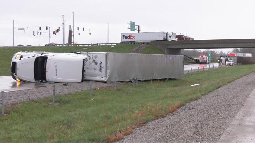
Semitrucks overturned on Interstate 265 in southern Indiana on April 2, 2024.
A semitruck overturned on Interstate 265 on April 2, 2024 in southern Indiana.
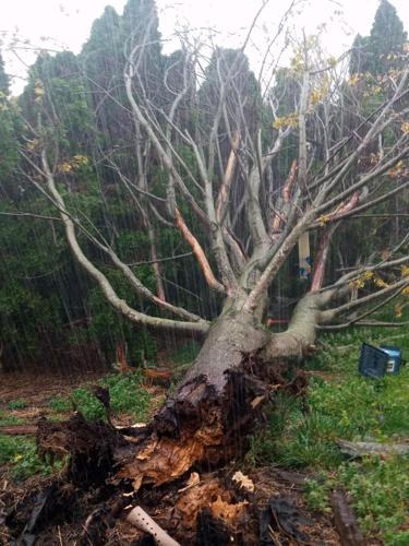
A tree uprooted near Norton Commons on April 2, 2024. (Submitted photo)

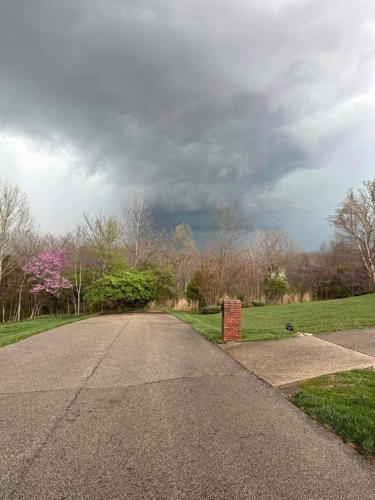
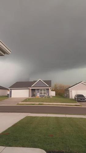
A storm cloud rolling through Crestwood, Kentucky. (Photo courtesy of Brett Cornell)
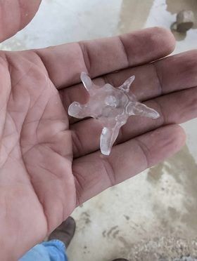
Hail from storms that rolled through Crothersville, Indiana on April 2, 2024. (Photo courtesy of Rex Robinson in Crothersville, Indiana)
Storm clouds on Highway 256 in Deputy, Indiana off Polk Road on April 2, 2024. (Photo courtesy of Melissa Campbell Colwell)
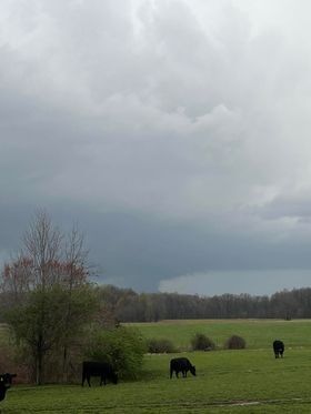
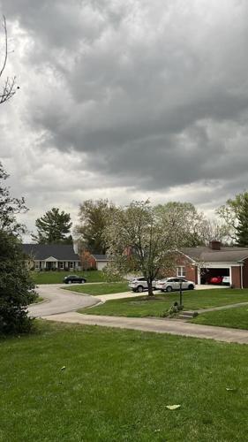
Storm clouds from severe weather that moved through southern Jefferson County near Wyandotte Park on April 2, 2024. (Photo by Bill Humphrey)

Photo courtesy of Michelle Culver
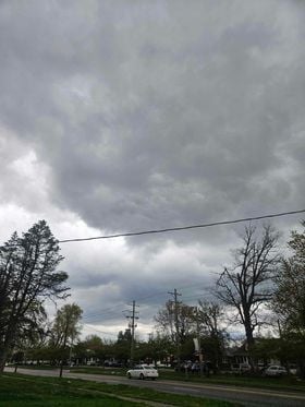
Storm clouds from severe weather that moved through the St. Matthews and Hurstbourne Parkway area on April 2, 2024. (Photo courtesy of Rob Couty)

A rainbow among storm clouds from severe weather that moved through Indiana and Kentucky on April 2, 2024. (Photo courtesy of Chrissy Howard)
Funnel cloud from a suspected tornado that moved through Jeffersonville, Indiana near Interstate 265 on April 2, 2024. (Photo courtesy Melissa Robinson)
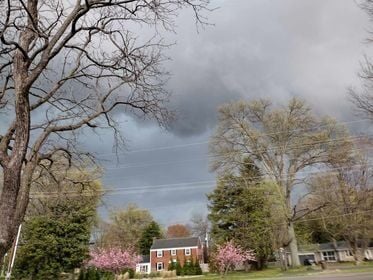
Storm clouds from severe weather that moved through Jefferson County, Kentucky near Seneca Park on April 2, 2024. (Photo courtesy of Manuela Mattingly)
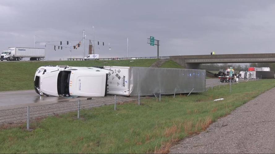
Semitrucks overturned on Interstate 265 in southern Indiana on April 2, 2024 due to severe weather.
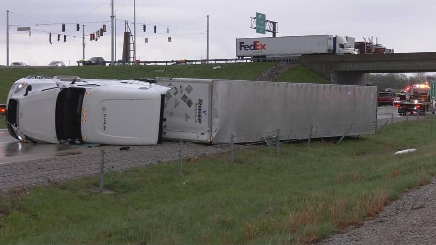
Semitrucks overturned on Interstate 265 in southern Indiana on April 2, 2024.
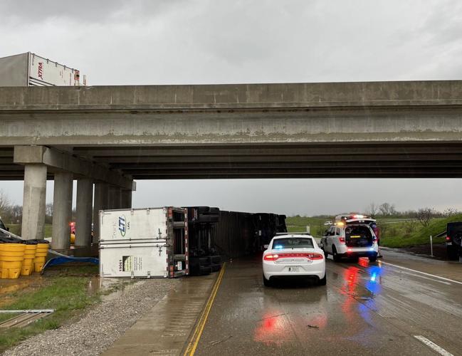
Semitrucks overturn on Interstate 265 in Jeffersonville, Indiana on April 2, 2024.
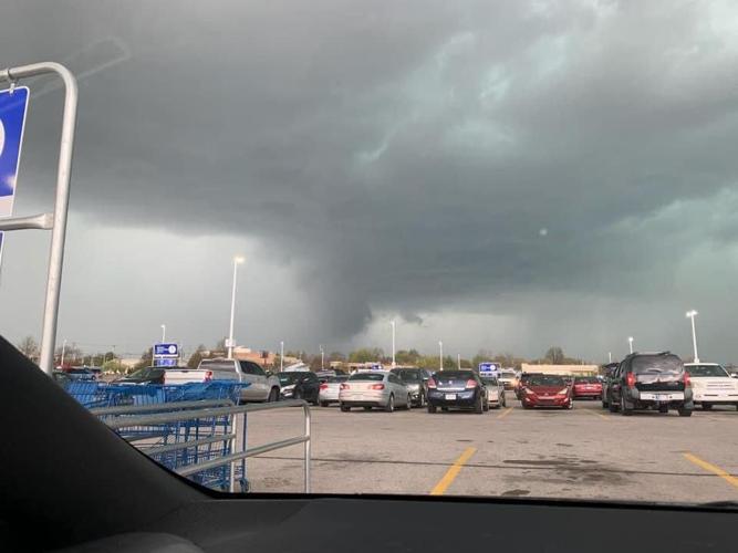
A funnel cloud from a suspected tornado spotted in Jeffersonville, Indiana at Meijer on 10th Street on April 2, 2024. (Photo courtesy of Marissa Hamlet)

Down powerlines at Oldham County High School in Kentucky from severe weather that moved through Oldham County on April 2, 2024. (Photo courtesy of Shaun Wallace on Facebook)

Storm clouds from a suspected tornado that moved through Jeffersonville, Indiana near the Boulder Creek subdivision on April 2, 2024. (Photo courtesy of Felicity Hawkins)

Storm clouds from a suspected tornado that moved through Jeffersonville, Indiana near the Boulder Creek subdivision on April 2, 2024. (Photo courtesy of Felicity Hawkins)
Storm clouds from a suspected tornado that moved through Jeffersonville, Indiana near the Boulder Creek subdivision on April 2, 2024. (Photo courtesy of Felicity Hawkins)
Storm clouds from a suspected tornado that moved through Jeffersonville, Indiana near the Boulder Creek subdivision on April 2, 2024. (Photo courtesy of WDRB Photojournalist Emily Evans)

Funnel clouds from a suspected tornado that moved through eastern Jefferson County on Brownsboro Road near the Gene Snyder Freeway on April 2, 2024.
Storm clouds from severe weather on Chelsea Meadow Court in Oldham County, Kentucky on April 2, 2024.
Tree damage by storms that moved through Jeffersonville, Indiana near the Boulder Creek subdivision on April 2, 2024. (Photo courtesy of Paul Jackson)
A piece of wood through the roof of a home after a suspected tornado moved through the Boulder Ridge Subdivision in Jeffersonville, Indiana on April 2. 2024. (Photo courtesy of Paul Jackson)
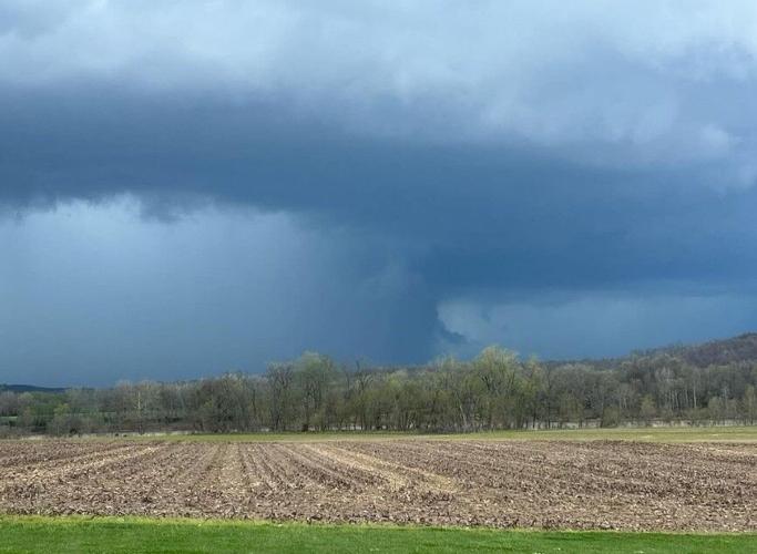
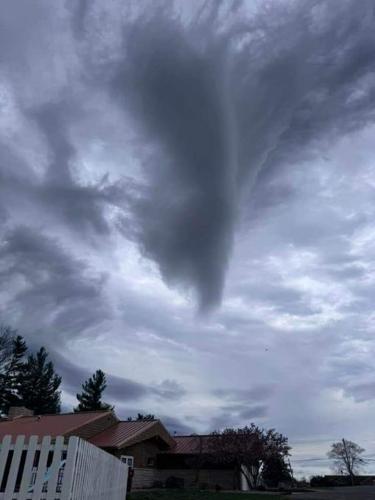
This viewer-submitted photo shows what appears to be a tornado that touched down Tuesday, April 2 2024 in Oldham County.
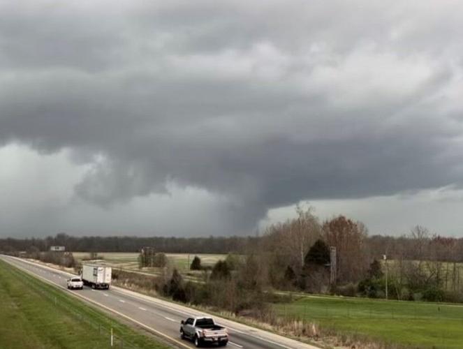
This viewer-submitted photo shows what appears to be a tornado that touched down Tuesday, April 2, 2024 in Oldham County.
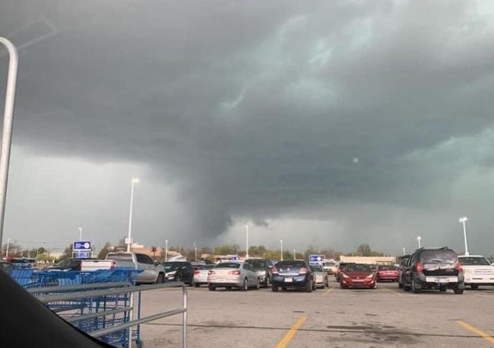
This viewer-submitted photo shows what appears to be a tornado that touched down Tuesday, April 2, 2024 in Oldham County.
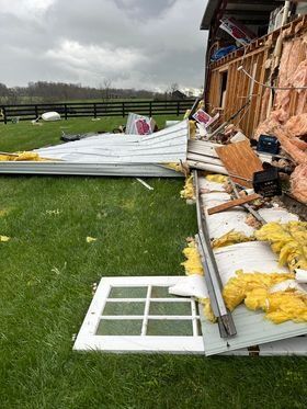
Damage from a suspected tornado that move through Henry County, Kentucky near New Castle. (Photo courtesy of Leslie Whaley)
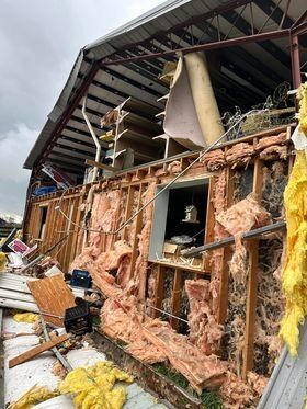
Damage from a suspected tornado that move through Henry County, Kentucky near New Castle. (Photo courtesy of Leslie Whaley)
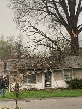
A tree fell on a house during storms that rolled through the Kentuckiana area on April 2, 2024. (Photo courtesy of Marriah Higdon)
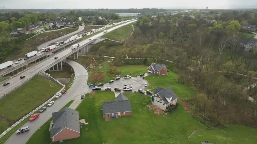
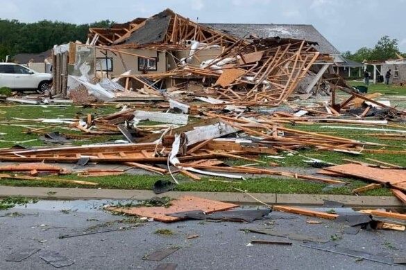
This aerial photo shows the damage from a suspected tornado that moved through Jeffersonville, Indiana on April 2, 2024. (WDRB image)
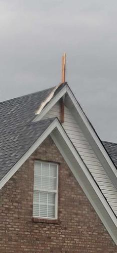
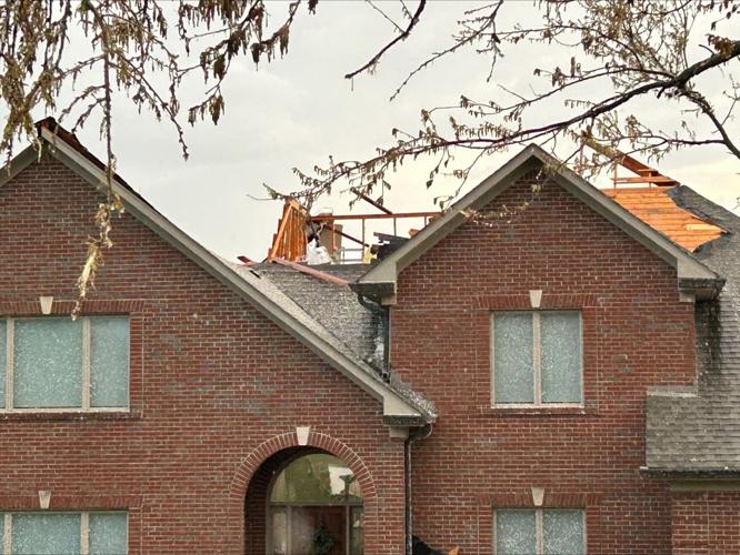
Roof damage from a suspected tornado that move through Buckner, Kentucky on Tuesday, April 2, 2024.
This aerial photo shows the damage from a suspected tornado that moved through Jeffersonville, Indiana on April 2, 2024. (WDRB image)

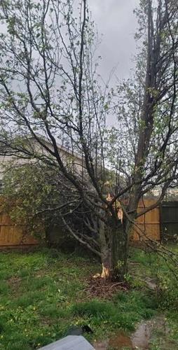
A tree uprooted on Sundancer Drive in Jeffersonville, Indiana from a suspected tornado on April 2, 2024. (WDRB image)

A tree uprooted on Sundancer Drive in Jeffersonville, Indiana from a suspected tornado on April 2, 2024. (WDRB image)
A tree uprooted on Sundancer Drive in Jeffersonville, Indiana from a suspected tornado on April 2, 2024. (WDRB image)
A tree fell on a home on Emerick Drive in Jeffersonville, Indiana from a suspected tornado on April 2, 2024. (WDRB image)
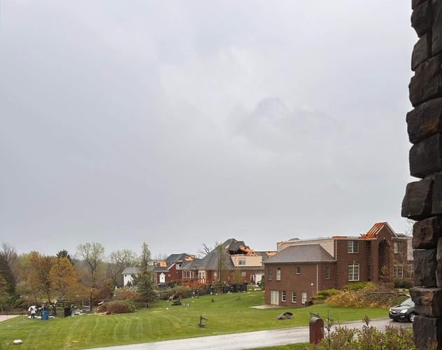
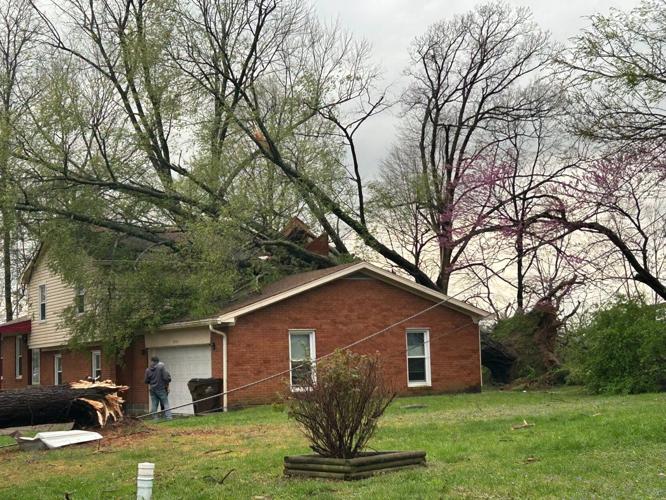
A home on Charlock Court in Prospect, Kentucky is damaged after a suspected tornado moved through the area on April 2, 2024. (WDRB image)
A home on Charlock Court in Prospect, Kentucky is damaged after a suspected tornado moved through the area on April 2, 2024. (WDRB image)
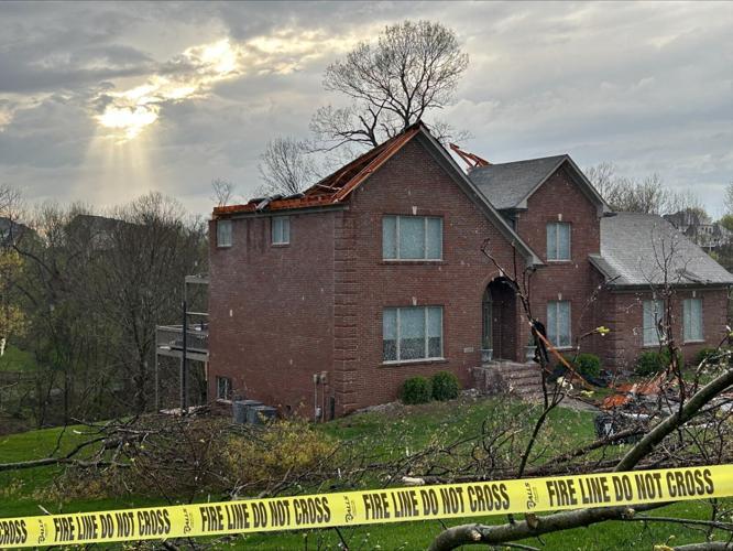
A home on Charlock Court in Prospect, Kentucky is damaged after a suspected tornado moved through the area on April 2, 2024. (WDRB image)

Debris strung in some trees on Charlock Court after a suspected tornado moved through the Prospect, Kentucky area on April 2, 2024. (WDRB image)
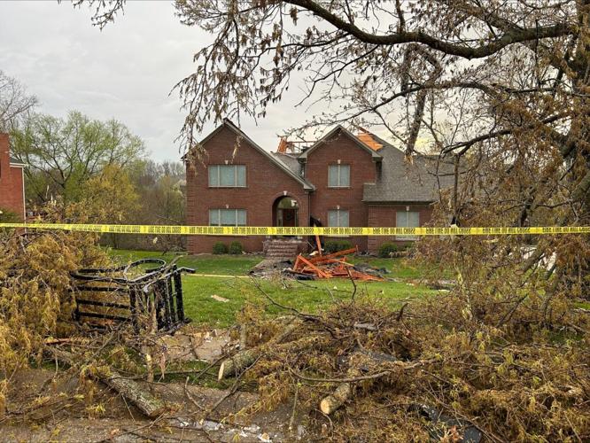
A viewer sent this picture of a home severely damaged from a suspected tornado that moved through Prospect, Kentucky on Tuesday, April 2, 2024.
A viewer sent this picture of a funnel cloud from a suspected tornado that moved through Prospect, Kentucky on Tuesday, April 2, 2024.
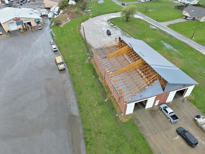
Half of the roof was blown off of the Leavenworth Fire Station 3 on Highway 66 in Carefree, Indiana when storms rolled through the area on Tuesday, April 2, 2024. (Photo courtesy of Milltown Police Department)
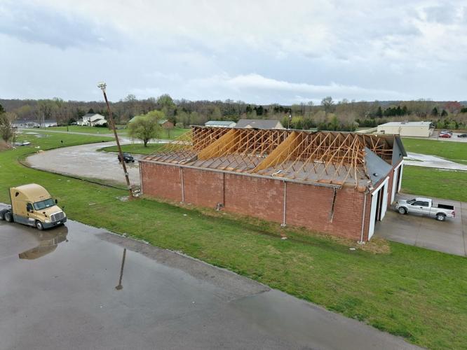
Half of the roof was blown off of the Leavenworth Fire Station 3 on Highway 66 in Carefree, Indiana when storms rolled through the area on Tuesday, April 2, 2024. (Photo courtesy of Milltown Police Department)
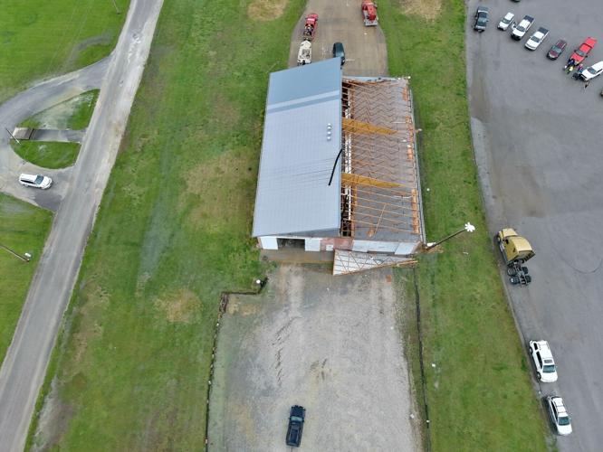
Half of the roof was blown off of the Leavenworth Fire Station 3 on Highway 66 in Carefree, Indiana when storms rolled through the area on Tuesday, April 2, 2024. (Photo courtesy of Milltown Police Department)
Clark County (Indiana) Sheriff Scottie Maples said Tuesday night that deputies were actively working "possible tornado damage" in the Quarry Bluff subdivision in Utica, and that there were "no life-threatening injuries." The subdivision is closed to anyone who doesn't live there or have immediate family who lives there.
In a news release, the Jeffersonville Police Department said there was "significant" damage to neighborhoods, and that multiple local agencies had responded to offer assistance, including first responders from Clark and Floyd counties.
"Community members are urged to remain vigilant and to exercise caution in affected areas," the department said. It's also asking non-residents to stay out of affected areas in an effort to avoid traffic congestion.
Jeffersonville police are asking residents to report additional damage to local authorities and Indiana 211 by calling 1-866-211-9966. They're also telling residents to "take proactive measures" to protect themselves from the possibility of contractor fraud when getting estimates on repairs.
The Leavenworth Fire Department in Carefree, Indiana, was hit by a possible tornado. The fire station suffered extensive damage to its roof, according to the Milltown Police Department.
Aaron Bye, with the Crawford County (Indiana) Emergency Management Agency, said half the roof of the Leavenworth Fire Station 3, on Highway 66 and Interstate 64, was destroyed.
At least six power lines are down on Kentucky 393 North, right by Oldham County High School, according to a photo sent in by a WDRB viewer. Another viewer said the roof was taken off a home on Chelsea Meadow Court, near La Grange, and viewer images from Jeffersonville also show damage to roofs and fences in Boulder Creek.
The possible tornado started in eastern Jeffersonville, Indiana, and moved across the Ohio River into the Prospect and Goshen areas.
In Henry County, Kentucky, about 25 firefighters from Louisville, PRP and Fern Valley fire departments gathered at Henry County High School in New Castle Tuesday night. They were called in to help check on residents, especially the elderly.
Henry County Schools spokesperson Melissa Blankenship said there was minor damage to Henry County High School in New Castle, but should be repaired by the time students return from spring break. Keepers Seafood restaurant on Lake Jericho Road in Smithfield also suffered some damage. Power is slowly being restored to parts of Henry County.
Mayor Craig Greenberg and officials with Louisville Fire provided an update on the impact the storm had in the area Tuesday evening. Greenberg said there were no injures to report in Louisville, and that the majority of damage was in Prospect.
Greenberg said he would be issuing a state of emergency for Jefferson County, and that Gov. Andy Beshear would be in the area on Wednesday assessing damage. Beshear had already declared a state of emergency in Kentucky following storms that hit Tuesday morning. An EF-1 tornado was confirmed in Nelson County.
According to LG&E outage map, there were more than 9,000 customers without power as of 4:30 a.m. Wednesday.
Much of Louisville was under a tornado watch following Tuesday evening's storms. That watch was canceled just before 9 p.m.
Shelters opening for those in need
Anyone in Clark County or Jeffersonville in need of shelter or assistance can go to Jeffersonville Fire Station 4, at 5311 State Road 62, just north of Utica-Sellersburg Road.
Officials were asking those needing shelter to be at the fire station by 11 p.m. Past that time, those needing resources or shelter are asked to call the Red Cross directly at 1-800-733-2767.
You can also call Clark County Emergency Management at (812) 246-6996.
Indiana
Clark County:
Clark County Emergency Management said the Arts & Enrichment Center in Charlestown (999 Water Street 47111) is currently open as a storm shelter for this event. This location opens during all severe weather events. No other locations have advised us if they are opening a storm shelter for this event.
Jefferson County:
Shelters are available at The Salvation Army at Walnut Street and Main Street in Madison, Indiana. There are also several volunteer fire departments and churches that open their doors -- each will announce the individually, since there is not regular staffing.
Washington County:
Salem Community Schools have safe rooms open when there is inclement weather. Schools closed at 1 p.m. Tuesday, but there will be someone there, if needed, according to emergency officials.
Kentucky
Jefferson County:
A Louisville Metro Emergency Services spokesperson said the public can go to any Metro Government building during regular business hours to seek shelter from inclement weather.
Oldham County:
Emergency Management said all Oldham County Fire Departments have temporary safe places for severe weather. Some churches have also been designated as temporary shelters for anyone's home that was destroyed.
Here is a list of all fire departments in Oldham County:
- La Grange Fire and Rescue station 1
- Ballardsville Fire Department
- South Oldham Fire Department
- Pewee Valley Fire Department
- North Oldham Fire Department
- Westport Fire Department
According to emergency management, these safe places must be activated by the respective department's command staff. They're not open 24/7, but each will typically be available if they know dangerous weather is approaching.
Also, the LaGrange Fire Dept. Station 1 will typically unlock its basement doors before any dangerous or severe storms.
Henry County:
Henry County Sheriff Keith Perry said the 4-H building at the Henry County Fairgrounds in Eminence will be open until midnight Tuesday for anyone needing shelter or assistance after the storm. That's located at 1106 Castle Highway (U.S. 421).
Safety tips from transportation officials
The Kentucky Transportation Cabinet wants residents to be aware if they're traveling on area roads and watch out for downed trees and other debris.
If there's a downed power line in the road, KYTC advises drivers to:
- Never touch or drive over a fallen line, report the issue to the power company
- Do not drive through standing water in case there is a downed line in it
- Stay inside your vehicle if a line has fallen on it as the ground may be energized. Sound your horn, call for help and call 911
- Assume all downed power lines are live and do not attempt to move one, even with non-conductive materials like wood or cloth
Additionally, power outages may cause issues for traffic lights. KYTC said when a light is blinking yellow, proceed through the signal intersection with caution when traffic allows. When a light is flashing red, treat the signaled intersection as a stop sign. When a light is completely out, treat the intersection like a 4-way stop sign.
This is a developing story that will be updated.
Related Stories:
- EF-1 tornado confirmed in Nelson County, state of emergency declared in Kentucky
- It's storm season in Kentuckiana: Here's what to know to stay prepared
- Tornado and hail leave extensive damage in multiple Kentucky, Indiana counties
- 'I feel real lucky' | Kentucky, Indiana residents picking up the pieces after being hit by tornado, hail
Copyright 2024 WDRB Media. All Rights Reserved.


