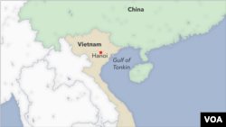
Vietnam is crying foul over a Chinese bid to redefine its coastal waters in the Gulf of Tonkin, a waterway at the northern end of the South China Sea lying between China's Hainan Island and Vietnam.
Beijing's delineation of a new baseline in the gulf was declared earlier this month. Under the U.N. Convention on the Law of the Sea (UNCLOS), a country's baseline is essentially its shoreline at low tide and is used to determine the extent of coastal waters and exclusive economic zones.
The convention makes exceptions in the case of close-in coastal islands, inlets and other unusual features, in which case a straight-line baseline may be applied. But experts say China has taken this provision to extremes by drawing a series of straight lines between islands far off its coast.
While the immediate implications of China's latest sea grab are limited, the experts say it could have implications for freedom of navigation in the region, and in an extreme case, Beijing could seek to apply the principle to declare the Taiwan Strait as Chinese coastal waters.
It also follows a pattern of aggressive Chinese behavior in the South China Sea, where since 2013 the country has been building artificial islands in waters claimed by Taiwan, Malaysia, the Philippines and Vietnam.
China says its delineation of the baseline in the Gulf of Tonkin, known as the Beibu Gulf in China, "strictly complies with domestic laws, international laws and bilateral agreements" and "will not impact Vietnam's interests or those of any other nation," according to a March 4 statement by the Chinese Foreign Ministry quoted by the official Global Times.
Hanoi disputes this assertion. When asked about the baseline more than a week later, its Foreign Ministry spokeswoman, Pham Thu Hang, stressed that "coastal countries need to abide by the UNCLOS 1982 when determining the baseline for measuring their territorial waters" and urged Beijing to honor a previously negotiated bilateral demarcation agreement in the gulf. UNCLOS was ratified in 1982.
Free of disputes
Unlike other parts of the South China Sea, the Gulf of Tonkin has been largely free of disputes since Hanoi and Beijing signed the delineation agreement in 2000 that went into effect four years later.
The Vietnamese Foreign Ministry spokeswoman declined to comment on whether China's new baseline could jeopardize that agreement, according to Reuters.
Hoang Viet, a lecturer at Ho Chi Minh City's University of Law who follows regional maritime issues closely, told VOA Vietnamese over the phone, "The gulf was already demarcated. China cannot claim more than what it agreed on in the deal, no matter what baseline it draws in the gulf."
He stressed that "it's almost impossible" for Beijing to amend the agreement already ratified by the two nations.
Raymond Powell, a team leader at Stanford University's Gordian Knot Center for National Security Innovation, told VOA Vietnamese in an email that China's baseline delineation varies from the standard UNCLOS practice, which says the baseline "must not depart to any appreciable extent from the general direction of the coast."
"China has drawn a straight baseline from its coast to a couple of offshore islands to illegally expand its territorial sea," Powell said. "UNCLOS does not allow drawing straight baselines except in extreme circumstances, such as the complex fjords of Norway. This is not one of those special cases."
According to UNCLOS, any waters inside the baseline are considered internal waters of a coastal state and unapproved passage of foreign vessels or aircraft is not allowed.
"The new baseline turns a significant area into China's closed waters. Qiongzhou Strait [the strait between Hainan island and the Chinese mainland] is now wholly China's internal waters," said Viet. "It affects the freedom of navigation of foreign vessels."
He added that China could cite this as a precedent to claim the Taiwan Strait as internal waters.
Powell predicted that Beijing's new claim "may someday" draw a U.S. Freedom of Navigation Operation (FONOP), in which a warship will enter an unrecognized claim and either transit without notification or conduct military activity. The United States "challenges excessive maritime claims around the world regardless of the identity of the claimant," according to the U.S. Navy press office.
Most FONOPs in the region have been confined to the South China Sea to challenge Beijing's territorial claims.