
A storm system moving through the Western United States will move through the Rockies and into the Plains over the weekend, bringing intense winds stretching from the Southwest to the Upper Midwest.
Wind alerts are in effect for nearly 18 million people from Texas to North Dakota.
The greatest threat of 100 mph winds will be near the base of the Rocky Mountain Foothills and will include areas near Boulder and Fort Collins, Colorado, according to the National Weather Service in Denver.
“An exceptionally strong storm will bring high winds this weekend,” the NWS said. “The Front Range mountains and foothills as well as the adjacent plains will see gusts around 80 mph with some areas possibly seeing 100 mph winds.”
The potential hurricane-force winds are expected to peak for the southern Rockies late Saturday before slowly decreasing on Sunday. The intense winds are expected to bring power outages, tree damage, travel disruptions and blowing dust.
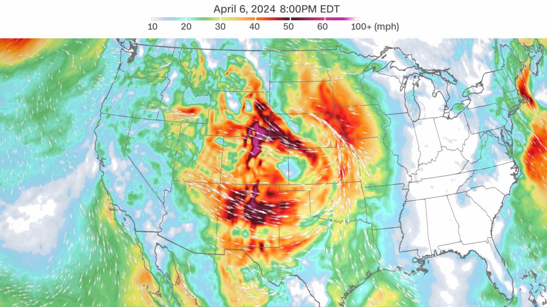
The winds are also combining with low relative humidity to create critical fire danger across the Southern High Plains, the weather service says. Areas from New Mexico and West Texas to southern Colorado and Kansas will be at the greatest risk, according to the agency. Any fires that start will be difficult to contain in the strong winds.
The fire threat has prompted emergency responses in Kansas and Texas, according to releases from the states’s emergency management operations.
Kansas Democratic Gov. Laura Kelly on Friday issued a verbal state of disaster, allowing resources to be used to provide state assistance, a release from the Kansas Division of Emergency Management said. Forecasts for the state show extreme fire weather for southwest and south-central Kansas with low relative humidity and wind gusts up to 55-60 mph, the release said.
“I urge all Kansans to refrain from burning during this period of extreme fire danger,” Kelly said. “By being vigilant, taking extra precautions, and reporting any fires to your local fire department, the risk of fires getting out of control can be minimized.”
In Texas, state emergency response resources were activated on Friday, a release from the Texas Division of Emergency Management (TDEM) said.
“With high fire danger expected, state emergency response resources have been activated to assist local wildfire response efforts, ensuring our communities are prepared to meet this weekend’s critical wildfire threat,” Texas Emergency Management Chief Nim Kidd said in the release. “TDEM and our Texas Emergency Management Council partners stand ready to support local officials with any requests for state emergency response assistance.”
The Central US is facing a mix of hazards this weekend. While the stage is set for critical fire weather in the central and southern High Plains, a winter storm will bring heavy snow over parts of the Central Rockies.
The incoming storm caused one local venue to cancel a Saturday concert and reschedule a Sunday concert. The Red Rocks Amphitheater near Morrison, Colorado, announced on social media that they would cancel the Dom Dolla’s Saturday show and postpone Daybreaker’s Sunday performance a week “due to dangerous wind conditions in the foothills.”
Heavy snow in High Plains this weekend
Following a deadly Nor’easter that brought heavy snow and strong winds to parts of the Northeast, another winter storm is set to cover parts of the High Plains this weekend.
Heavy snow is forecast to fall at up to an inch per hour, with snowfall totaling 6 to 12 inches, and 1 to 2 feet in higher elevations, according to the National Weather Service.
Near-blizzard conditions and snow-covered roads are expected Saturday night into Sunday morning in the High Plains, with localized blizzard conditions at higher elevations, according to the weather service.
The National Weather Service warns of hazardous driving conditions, telling drivers in the region to “drive with extra caution” due to reduced visibility and whiteout conditions.
States including Wyoming, Nebraska, Colorado, Montana and South Dakota are expected to see impacts from the snowstorm’s strong winds and heavy snow.
“Falling and blowing snow may create difficult travel conditions over northeastern Wyoming Saturday night and Sunday,” the weather service said.
Snow showers are also expected to continue from the Central Appalachians up through the Lower Great Lakes as well as the interior Northeast and New England. Light snow accumulations between 3 to 6 inches are possible for those areas before things begin to clear up Saturday evening.
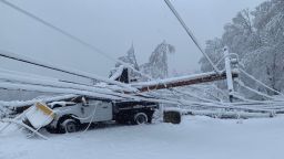
This comes after strong winds and heavy snow downed trees, shuttered roads and cut power to hundreds of thousands in Maine and New Hampshire earlier this week. As of Saturday morning, more than 201,000 homes and businesses were still without power in Maine and New Hampshire combined, according to poweroutage.us.
Winds will strengthen again Saturday with gusts up to 30 mph, the weather service says.
Winter weather advisories are in effect for some parts of Nevada until 5 p.m. Saturday, with snow accumulations up to 10 inches and winds gusting as high as 50 mph, according to the weather service. Some parts of Idaho, Oregon, Montana and Utah were likewise under advisories. Winter storm warnings are also in effect for some parts of Wyoming and Nebraska starting late Saturday afternoon.
CNN’s Zoe Sottile, Dalia Faheid and Rebekah Riess contributed to this report.