

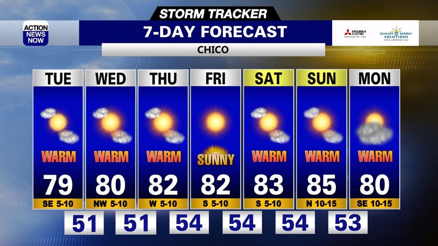
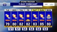

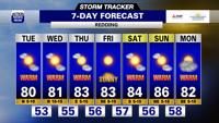

It's a good idea to throw on light layers, grab your sunglasses and pack some extra water as you get ready to head out the door Tuesday. Mostly sunny to partly cloudy skies, a mild morning and warmer afternoon are on tap for today. Not much variety ahead. Partly cloudy to mostly sunny skies, milder mornings and slightly warmer afternoons are on the way for the rest of this week into this weekend.
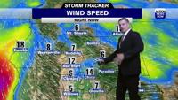
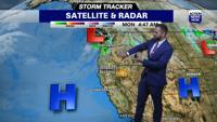
It's a good idea to throw on light layers, grab your sunglasses and pack some extra water as you get ready to head out the door Tuesday. High pressure centered off the West Coast in the Pacific will continue to build into northern California Tuesday, and that will drive dry weather and warming temperatures today. An additional ridge of high pressure to our north will also help to keep the West Coast dry. We've had clear skies over our region overnight, but will end up mostly sunny to partly cloudy through the day today. Temperatures have dipped into the upper 40's to low 50's in the valley, 40's in most foothill areas, and 20's to 30's in our mountain zones early Tuesday morning. Winds will be out of the north to 10mph, and gusts will only be modestly stronger than that early to mid-day. High temperatures are projected to climb into the upper 70's to lower 80's in the valley, 60's to mid 70's in the foothills, and 60's to lower 70's in our higher elevations Tuesday afternoon.
High pressure off the coast will continue to slowly build into northern California through the rest of this week, and that will drive dry and warming conditions across our region through this weekend. We'll have mostly sunny to partly cloudy skies over the next several days. Temperatures will start out in the low to mid 50's in the valley, 40's to 50's in the foothills, and 30's to 40's in our mountain zones from Wednesday through this weekend. High temperatures will end up in the low to mid 80's in the valley, and 60's to 70's in our foothill and mountain zones through the end of your work week. Projections then have our high temperatures getting even warmer this weekend. Mid to upper 80's are projected for the valley, and 60's to upper 70's are projected for the afternoons in our mountain and foothill areas this weekend. The trend of dry weather and above average temperatures will persist into early next week.