As one of the most photographed, filmed and crooned about places in the world, California often feels like an idea as much as a state, deeply familiar even to those who have never been here. Yet the best of California is not what we have built. The source of California’s true power is its wilderness.
Wilderness gives us permission to be small, to be dwarfed by places that are greater than us and to feel awe at being part of it. Being in nature allows us to step into a timescale beyond ourselves, to unburden our cluttered minds and become totally engrossed in the present. That’s part of the reason why, after emerging from the depths of the pandemic, my partner, Caroline, and I bought an old motorhome and, along with our toddler, spent six months exploring and photographing the state’s wildest places.
The variety of environments is what makes California special, and water is the access point to exploring these many wild and diverse identities. Water shapes and nourishes the state. It links land and culture, from hot springs to mountain lakes, granite gorges to sheltered beaches, secret waterfalls to rivers that meander through redwoods, vineyards and sleepy towns.
Quick GuideHow to be a good human in the outdoors
Show
It’s really quite simple: be kind and don’t leave a mess behind. Be considerate of all shared spaces and the locals who love them.
Swimming is an essential part of any outdoor adventure and it is up to you to assess the water, any potential hazards and the weather. Know your own swimming ability and, more importantly, know your limitations. Your safety is your own responsibility, and a little bit of common sense will go a long way.
Here are some tips for outdoor etiquette and safe swimming.
- Don’t leave trash behind and collect any extra bits that you find.
- The seven principles of “leave no trace” are a gold standard. They include planning ahead, disposing of waste and respecting wildlife. More detail can be found at lnt.org.
- When entering a swimming spot, look for natural hazards, such as snags and submerged objects. Be aware that even in sleepy-looking rivers, currents may be much stronger than they appear.
- Check the water temperature before jumping in, and the depth (it can be very deceptive). Swim with a buddy, and put small children in life jackets.
- Don’t swim in water with algal blooms. These are common toward the end of the summer in low-elevation rivers and lakes where the water temperature is warm.
- When visiting a hot spring, be respectful. These are quiet places, not party places. Keep your voice low, don’t play music and don’t bring your barking dog. Don’t use soaps or fragrance; it’s not your personal bathtub. Kids may be welcome in some places but not others, so assess the vibe and use your best judgment.
- Avoid submerging your head in a wild hot spring. There is always a (tiny) risk of the presence of Naegleria fowleri, a lethal brain-eating amoeba that thrives in hot temperatures.
- Always. Have. Fun.
For all its world-famous destinations, it’s the less-travelled locations that reveal the best of the state, from its raw beauty to authentic weirdness. Here are five of the most memorable places where we swam that you may (or may not) have heard of – guaranteed to bring you joy.
Smith River confluence
Six Rivers national forest

Driving inland from Crescent City along Highway 199 is an exercise in divided attention. Your awareness is constantly drawn to the shimmering form of the Smith River, in tantalizing glimpses that threaten to pull you off the windy road. The river is designated “wild and scenic” – the only major river system in California to flow freely and naturally, without a single dam for its entire length. The water is irresistible, its iridescent blues and greens so clear that you can watch shoals of native salmon and trout swirl deep below the surface.
Some of the best swimming holes are around the confluence of the north and south forks. Locals call this area “second bridge”, but the official name is Nels Christensen Memorial Bridge, and it’s easily recognizable by the long rope swing that hangs from the arching span. Here, the relatively warm waters of the south fork gently lap along the shallow, pebble beach as the river bends downstream. People of all ages howl with a mixture of joy and fear as they leap from blocky cliffs into the deep water below.
The river is flanked by a lush mixed-evergreen forest, which includes the 300ft giants of Jedediah Smith Redwoods state park and Redwood national park. This region contains nearly half of all the remaining old-growth coast redwoods in the world.
Ancestral homelands: Tolowa Dee-Ni’
Best time to visit: June to October
How to get there: From Crescent City, take Highway 199 inland for 11.5 miles to the South Fork Road turnoff at Myrtle Beach. It’s a further quarter mile to the Forks River access and boat ramp parking lot.
Access: Easy. From the parking lot, the trails split to second bridge and further downstream to the cliffs at the confluence. Either direction is about 200 yards and relatively flat. Keep an eye out for poison oak.
Safety: Swimming can be dangerous in the wrong conditions. Carefully inspect water levels and river currents before jumping in.
Closest campsite: Jedediah Smith campground (3 miles)
Keough’s hot spring
Bishop

Any trip to the eastern Sierra isn’t complete without a soak in Keough’s hot spring. The Owens Valley Paiute call these springs u’tu’utu paya. It’s a sacred site for bathing and healing and was once the center of a permanent Paiute village. While the Bishop area has many well-known natural springs, there is a strong case to be made for minimizing our impact on wild places by visiting maintained facilities.
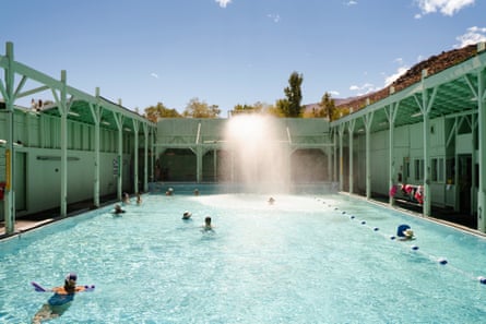
There is a time for dirt roads and friendly conversation with naked strangers; and, there is a time for floating on a pool noodle in a giant concrete tub and dipping a soft pretzel into molten cheese sauce. For the latter, you can’t do better than Keough’s.
The art deco bathhouse has hardly changed since it was built in 1919, with open-air bathing surrounded by a mix of covered decks and sun lounges. Its cool-mint facade stands in contrast to the (literally) piping hot water, which starts at 130F and is cooled through a series of fountains to reach the two pools at a safe temperature.
The mineral rich waters are an extension of the surrounding wilderness and make for the perfect beginning and ending to many skiing, backpacking, and climbing trips. Or just a restful stop as you travel Highway 395. There is nothing better than winter storm days at Keough’s. When it is dumping snow up in the mountains, you can still get sunshine on the pool deck and protection from the wind. Locals sit out here in the sun and plot the next week of powder runs.
Ancestral homelands: Ütü’ütü witü of the Nüümü (Owen’s Valley Paiute)
Best time to visit: Year-round
How to get there: Eight miles south of Bishop on Highway 395. A similar distance north of Big Pine.
Closest campsite: Campground on site
North Fork American River
Auburn state recreational area

The bright, clear water of the north fork of the American River originates in the Sierra Nevada north-west of Lake Tahoe. From there it carves through miles of rugged and remote wilderness, scouring a deep canyon on its journey to the Sacramento valley. Rock walls rise more than 2,000ft above the river for much of its length, creating an impenetrable sanctuary that is one of the great refugia for wildlife in the northern Sierra.
Although the wild landscape has resisted roads and development for centuries, there are a couple of access points to the river along its length. For swimming and hiking, Mineral Bar campgrounds is the perfect entry. The Colfax-Iowa Hill bridge, a wire suspension bridge built in 1923, is a popular put-in/take-out spot for whitewater rafting during the spring and early summer. By July, the water levels are typically low enough that it becomes a family-friendly swimming hole known as ”the bubble bath”. However, the best spots are further upstream.
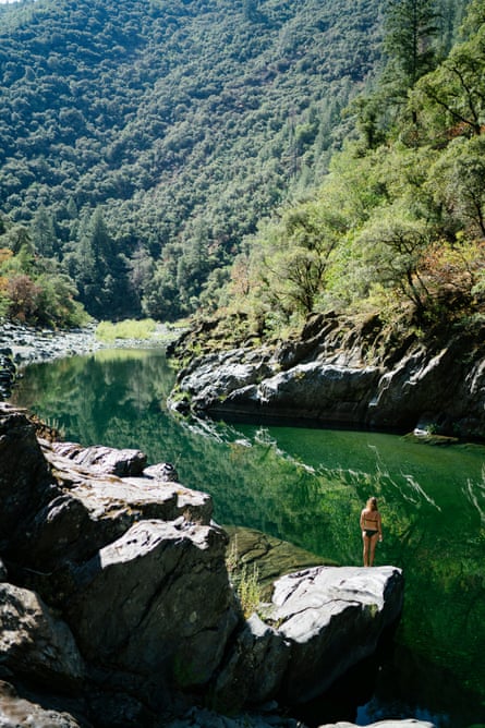
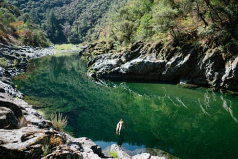
This stretch of river has some of the friendliest “wet” hiking around. Gold panners have worn unofficial trails on the banks, but it is generally easiest to stick to the riverbed. Wade knee- or waist-deep through the water, crossing frequently to avoid obstacles. At almost every bend, the river scours swimming holes, which must obligingly be plunged into before continuing upstream. After about 1.25 miles, you will reach a huge, deep pool defined by large slabs of greenstone on all sides. Enormous trout lurk in the shadowy depths and flecks of sand (or is it gold?) glint in the sun. Let the day slip away and enjoy this perfect slice of undisturbed wilderness.
Ancestral homelands: Nisenan
Best time to visit: June to September (depending on snowpack)
How to get there: From downtown Colfax, take S Auburn Street 0.3 miles to Highway 174. Turn left and cross the I-80 overpass, then turn right on Canyon Way and drive south for 0.3 miles to reach Iowa Hill Road. Turn left and follow Iowa Hill Road for 3 miles, as it winds down to the river and Mineral Bar campgrounds.
Access: Moderate. There are no trails north of Mineral Bar campgrounds, so you have to walk in the river and along the banks to reach the pool, a mile-plus upstream.
Safety: Swimming can be dangerous in the wrong conditions. Carefully inspect water levels and river currents before jumping in.
Closest campsite: Mineral Bar campgrounds, located at trailhead
Kaweah River
Sequoia national park

Every part of the Sierra Nevada is perfect in its own way, but the southern Sierra possesses all of the granite majesty, wildlife and pristine water with a fraction of the visitors. The Kaweah River perfectly embodies this wilderness area as it begins high up in Sequoia national park and tumbles nearly 10,000ft in 20 miles to reach the foothills town of Three Rivers. It’s one of the steepest watersheds in America, and at times it feels like it is barely contained by its own banks.
For much of the year, the river roils with whitewater, surging across the bedrock and cartwheeling over waterfalls to scour the riverbed below. Finally, just as the summer heat becomes unbearable, the water drops to a safe level. The river slows to reveal still, green pools and sandy beaches. Polished granite slabs sparkle in the sun. It’s worth the wait.
“The cliffs” is a swimming hole just within the Sequoia national park gate, making it an excellent beginning and/or ending to adventures in the area. Despite being only a five-minute walk from the road, most people fly past on their way up to see the big trees.
From the road, it’s about a five-minute walk to the river. Take the well-defined trail down the hillside and then follow the path upstream a few hundred feet. The main pool is immediately recognizable for its high granite walls, which channel the river into a narrow chute. At the top end, a waterfall spills into the cañoncito, with excellent jumping rocks and ledges on both sides. It is reliably deep but be sure to inspect the landing for yourself. You never know what trees or boulders may have washed into the swimming hole between visits.
Ancestral homelands: Nyyhmy (Western Mono/Monache)
Best time to visit: June to September (depending on snowpack)
How to get there: If you drive north from Three Rivers on Highway 198, the trailhead is located about 0.6 miles past the Sequoia national park entry station. Look for a turnout on the right with room for three to five cars. The well-defined path leads between the southern Sierra research station and two concrete ponds. If you get to the visitors’ center, you have gone too far.
Access: Easy. From the road, it’s about a quarter mile down to the river. There is one steep section with good footing that will take you to the water’s edge. From there, follow the trail a couple hundred feet upriver to reach the cliffs and rock jumps.
Safety: Swimming can be dangerous in the wrong conditions. Carefully inspect water levels and river currents before jumping in.
Closest campsite: Potwisha campground, Sequoia national park (3 miles)
Black’s beach
Torrey Pines state natural reserve

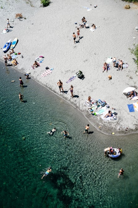
This San Diego beach is a piece of wilderness hidden within a major metro area. Black’s is unusual by southern California standards in that access is limited and it’s virtually invisible from the road. Therein lies both the challenge and the appeal. You can park on the mesa above and walk down via steep trails, or else take a long walk along the beach from either end. It’s just the right level of effort to ensure that there are never too many people.
We always approach from the top, at Torrey Pines state natural reserve. The beloved park supports more than 400 varieties of native plants and wildflowers. Coastal sage scrub, maritime succulents and chaparral line the high broken cliffs and deep arroyos, which provide one of the world’s only sanctuaries for the enigmatic, wind-sculpted Pinus torreyana. Gravel trails wind among plant communities and past stunning coastal lookouts before funneling hikers down to Flat Rock beach below.
Walk south around the headland to reach the long, open stretch of Black’s beach. Warm red, orange and yellow saturate the pockmarked 300ft cliff face, which extends above miles of beach. Time your visit with low tide, when the sandy beach is widest. This allows you to keep a distance from the tall cliffs, which periodically collapse. We try to stay at least 30ft from the base.
The north end of Black’s is designated clothing-optional, and if you have never had a nude swim in the ocean, this is the place. The turquoise water is as warm as it gets in California. As you stretch out in the summer sun, it’s easy to forget you are in the middle of a sprawling city.
Ancestral homelands: Kumeyaay
Best time to visit: May to September. Low tide only.
How to get there: 12600 North Torrey Pines Road, La Jolla
Access: Moderate. It’s about a one-mile walk from the top of Torrey Pines state natural reserve to Flat Rock beach below, around the corner from Black’s beach. You can also approach from La Jolla Shores to the south or Torrey Pines state beach to the north. Low tide only.
Safety: Stay away from unstable cliffs and don’t attempt to swim in the ocean when there are large waves.
Dillon Seitchik-Reardon is the co-author and photographer of Places We Swim California (Dillon Seitchik-Reardon and Caroline Clements, 2024) published by Hardie Grant USA. It’s a guide to the best rivers, lakes, waterfalls, beaches, gorges and hot springs in California
