First Warn Weather, Madison's certified most accurate forecast by WeatheRate

Tracking a line of storms this evening, and then another chance of storms later this week - Alex

​COPYRIGHT 2024 BY CHANNEL 3000. ALL RIGHTS RESERVED. THIS MATERIAL MAY NOT BE PUBLISHED, BROADCAST, REWRITTEN OR REDISTRIBUTED.

WHAT WE'RE TRACKING: 

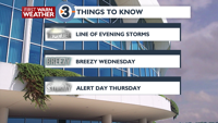
Showers and storms tonight
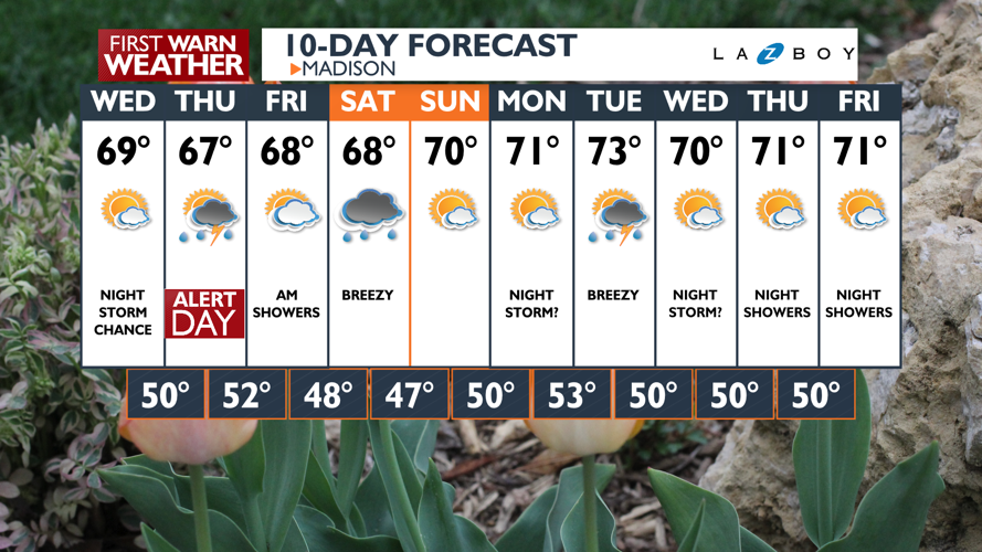
Mild on Wednesday

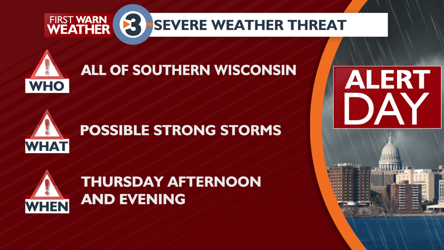
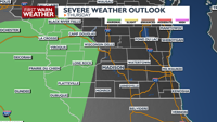
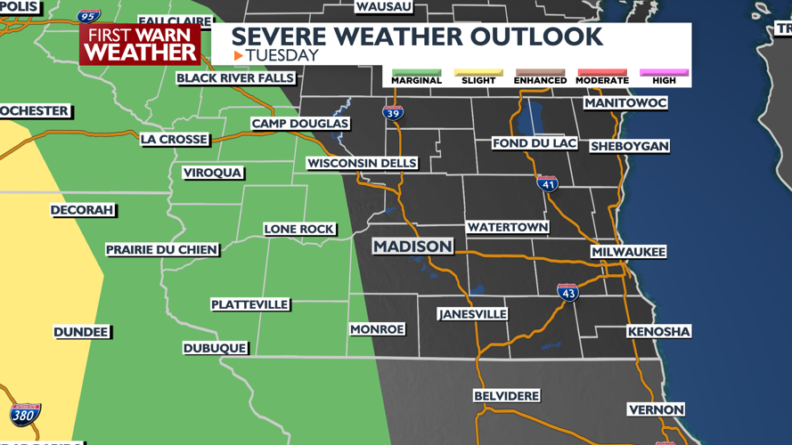
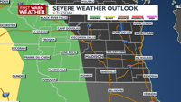
ALERT DAY for more storms Thursday

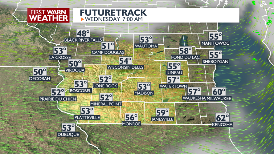
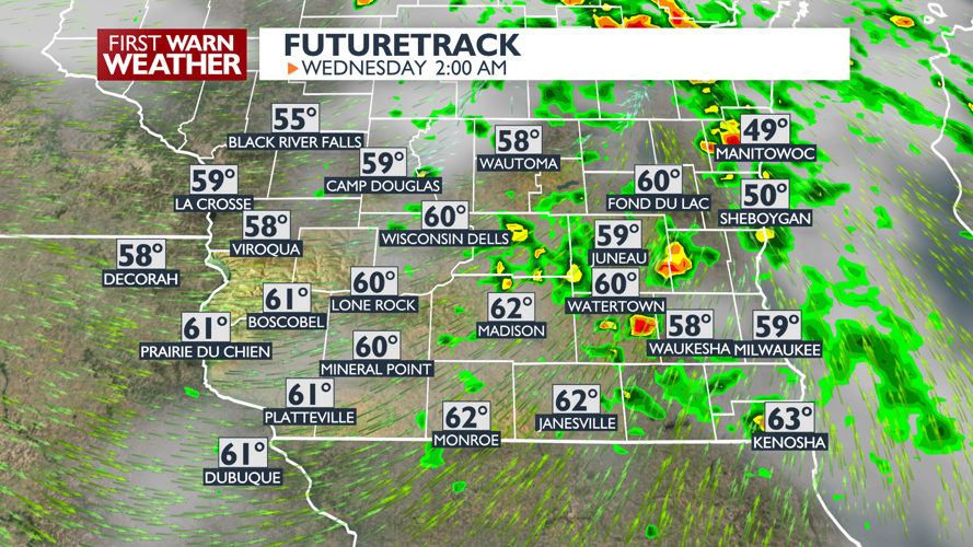
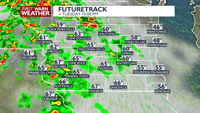
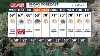
PLANNING THE NEXT 24 HOURS:  Showers and thunderstorms are likely tonight. A strong storm is possible near the Mississippi River, if the line of storms can hold together. The line of storms will be weakening as they move east. Areas east of Madison may only see scattered showers. Wednesday looks breezy, yet mild.

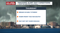
EXTENDED FORECAST: You will not need your umbrella on Wednesday, but Thursday will bring another chance for showers and thunderstorms, with showers possibly lingering into Friday morning. An ALERT DAY is in the forecast for Thursday for the possibility of severe weather, provided we get enough dry time to warm up enough as fuel for stronger storms. Like last Sunday, it is possible that a warm front moving north on Thursday may not make it into the area, which could also reduce the heat needed for stronger storms. Dry weather will return for the upcoming weekend with just a chance for showers Saturday.

COPYRIGHT 2024 BY CHANNEL 3000. ALL RIGHTS RESERVED. THIS MATERIAL MAY NOT BE PUBLISHED, BROADCAST, REWRITTEN OR REDISTRIBUTED.

Madison, WI

Right Now
71°
Sunny
  • Humidity: 54%
  • Feels Like: 71°
  • Heat Index: 71°
  • Wind: 8 mph
  • Wind Chill: 71°
  • UV Index: 0 Low
  • Sunrise: 05:52:13 AM
  • Sunset: 07:58:35 PM
  • Dew Point: 54°
  • Visibility: 10 mi

Today

Mostly sunny and mild Wind: SW 6-12 MPH

Tonight

Mostly cloudy and milder with scattered showers and storms. (A strong storm is possible west of Dane County, closer to the Mississippi River.) Wind: S 8-15 MPH

Tomorrow

Partly sunny, breezy, and mild. Wind: NW 10-20 MPH, gusts to 25 MPH

Day
Temp
Tue
53°
71°
Tue
71°/53°
Thunderstorms. Lows overnight in the mid 50s.

Chance of Rain: 10%

Sunrise: 05:52:13 AM

Sunset: 07:58:35 PM

Humidity: 74%

Wind: SW @ 10 mph

UV Index: 0 Low

Tuesday Night

Mostly cloudy and milder with scattered showers and storms. (A strong storm is possible west of Dane County, closer to the Mississippi River.) Wind: S 8-15 MPH

Wed
50°
69°
Wed
69°/50°
Plenty of sun. Highs in the low 70s and lows in the low 50s.

Chance of Rain: 10%

Sunrise: 05:50:49 AM

Sunset: 07:59:45 PM

Humidity: 52%

Wind: NW @ 12 mph

UV Index: 7 High

Wednesday Night

Becoming mostly cloudy with a chance of showers and thunderstorms. Wind: NE 5-10 MPH

Thu
52°
67°
Thu
67°/52°
Mainly cloudy and rainy. Highs in the upper 60s and lows in the mid 50s.

Chance of Rain: 70%

Sunrise: 05:49:27 AM

Sunset: 08:00:54 PM

Humidity: 75%

Wind: ESE @ 16 mph

UV Index: 3 Moderate

Thursday Night

Scattered showers and storms

Fri
48°
68°
Fri
68°/48°
More sun than clouds. Highs in the upper 60s and lows in the upper 40s.

Chance of Rain: 30%

Sunrise: 05:48:05 AM

Sunset: 08:02:03 PM

Humidity: 66%

Wind: NW @ 11 mph

UV Index: 7 High

Friday Night

Mostly Cloudy with a slight chance of showers.

Sat
47°
68°
Sat
68°/47°
Mostly cloudy. Highs in the upper 60s and lows in the mid 40s.

Chance of Rain: 30%

Sunrise: 05:46:46 AM

Sunset: 08:03:11 PM

Humidity: 59%

Wind: NNE @ 10 mph

UV Index: 5 Moderate

Saturday Night

Variable cloudiness and cool.

Sun
50°
70°
Sun
70°/50°
Mix of sun and clouds. Highs in the low 70s and lows in the low 50s.

Chance of Rain: 10%

Sunrise: 05:45:27 AM

Sunset: 08:04:20 PM

Humidity: 59%

Wind: ENE @ 8 mph

UV Index: 7 High

Sunday Night

Partly cloudy.

Mon
53°
71°
Mon
71°/53°
A few thunderstorms possible. Highs in the mid 60s and lows in the low 60s.

Chance of Rain: 20%

Sunrise: 05:44:10 AM

Sunset: 08:05:28 PM

Humidity: 75%

Wind: SE @ 14 mph

UV Index: 6 High

Monday Night

Chance of showers and storms.

Tue
50°
73°
Tue
73°/50°
Scattered thunderstorms. Highs in the low 70s and lows in the upper 50s.

Chance of Rain: 30%

Sunrise: 05:42:55 AM

Sunset: 08:06:36 PM

Humidity: 73%

Wind: SSW @ 17 mph

UV Index: 6 High

Tuesday Night

Showers in the evening, then partly cloudy overnight.

Wed
50°
70°
Wed
70°/50°
Showers possible in the afternoon. Highs in the low 70s and lows in the mid 50s.

Chance of Rain: 20%

Sunrise: 05:41:41 AM

Sunset: 08:07:43 PM

Humidity: 67%

Wind: W @ 15 mph

UV Index: 7 High

Wednesday Night

Partly cloudy

Thu
50°
71°
Thu
71°/50°
Partly cloudy. Highs in the low 70s and lows in the mid 50s.

Chance of Rain: 10%

Sunrise: 05:40:29 AM

Sunset: 08:08:51 PM

Humidity: 68%

Wind: SW @ 11 mph

UV Index: 7 High

Thursday Night

Chance of showers.

Radar Loops and Maps

Weather News

AP top story

Powerful storms are rumbling over parts of the southeastern U.S. as more severe weather takes aim at parts of the Ohio Valley. The storm system has already been blamed for at least one death in Mississippi and flooded streets in the New Orleans area. Damage has been reported from Texas to the Florida Panhandle. More than 100,000 customers lack power. Now forecasters say parts of Ohio, Kentucky and West Virginia will be near the bull's-eye of a new area of concern Thursday. The Storm Prediction Center says those areas could see some tornadoes, damaging winds and large hail.