Philadelphia forecast: NEXT Weather Alert issued for heavy rain, possible thunderstorms Wednesday
PHILADELPHIA (CBS) -- Another 1.37 inches of rain was added to the rain bucket Tuesday, bringing our April total to nearly 2 inches just two days into the month.
On Wednesday, we'll likely add another 1-2 inches in overall totals, but some spots may get even more than that.
The daily rain record for April 3 is 2.28 inches, set in 1915. If we end up getting 1.49 inches or more, it'll be the wettest start to April ever recorded. The current record is 2.85 inches between April 1-3, 2005.
Tornado watch, warning expire in Kent County and Sussex County, Delaware
A Tornado Warning issued by the National Weather Service for Kent County and Sussex County in Delaware expired at 7 p.m.
A Tornado Watch issued for southwestern Sussex County in southern Delaware also expired at 5:45 p.m.
New Castle County was not included in the watch or warning.
Rain all day
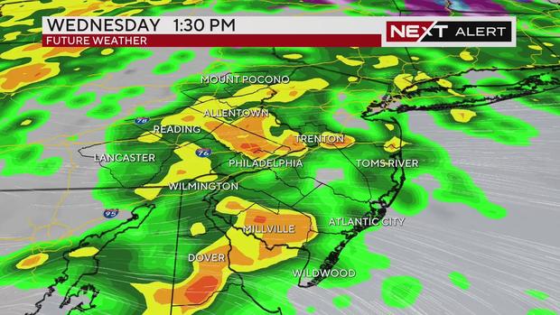
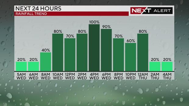
In addition to consistent rain throughout the day, we're looking at the possibility of a strong storm or two that could become thunderstorms Wednesday. That's why our team has issued a NEXT Weather Alert Day for the region.
According to meteorologist Kate Bilo, the heaviest rain will likely fall between around 10 a.m. and 3 p.m. but before and after that period we'll still have showers.
Winds also pick up throughout the day Wednesday as the system moves through and will especially batter the coastline, where gusts could reach 40 mph and even higher across parts of northern New Jersey. In the city, gusts could reach 30 mph out of the east.
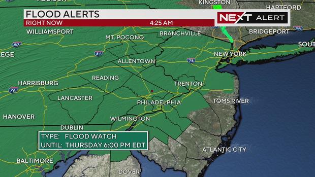
Flood Watch, local flood warnings including Perkiomen, Brandywine Creek
A Flood Watch is in effect for almost the entire Delaware Valley until 6 p.m. Thursday. Areas along the coast are also under a Coastal Flood Advisory for the high tides Wednesday afternoon/evening and Thursday morning.
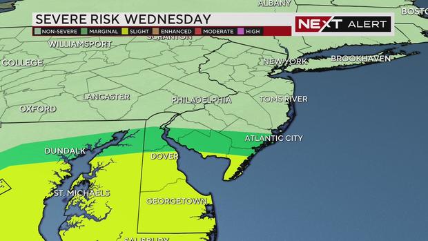
Parts of South Jersey and Delaware are under a Level 2, or marginal risk, for severe weather Wednesday.
A Flood Warning is in effect for areas around the Perkiomen Creek in the northernmost corner of Montgomery County until 11:30 a.m. Wednesday. About an inch of rain has already fallen and flooding is reported in spots around here.
A flood watch means to be on the lookout as there are favorable conditions that could produce flooding, while a warning means flooding has been observed in the area.
Data from the National Weather Service shows water levels of the Perkiomen Creek in East Greenville at around 5.7 feet, above flood stage of 5 feet.
Another flood warning is in place for areas around the Brandywine Creek, which data from the National Weather Service shows crossed the minor flood stage near Downingtown around 8 a.m. Downstream at Chadds Ford, the creek was forecasted to be close to minor flood stage in the early hours of Thursday morning.
Minor flooding has also been observed at the Christina River in Wilmington, Delaware and the Delaware Bay at Reedy Point.
Other local bodies of water were also at risk of reaching flood stage this week. The Rancocas Creek was expected to crest around 2.8 feet, above the minor flood stage of 2.5 feet, on Thursday morning.
The Delaware River was also nearing minor flood stage with a chance of crossing it on Thursday morning.
When does the rain clear out?
A few showers are still likely Thursday afternoon, but then we'll finally dry out Friday and into the weekend. High temperatures all week remain cooler than normal in the low 50s, but by Sunday temps will finally get back to up 60 degrees.
Here's your 7-day forecast:
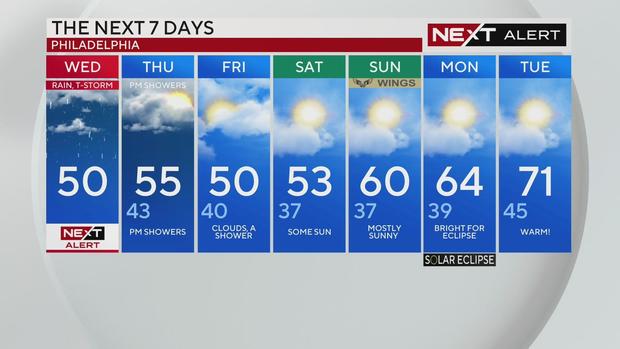
Wednesday: High of 50, NEXT Weather Alert Day
Thursday: High of 55, low of 43, PM showers
Friday: High of 50, low of 40, clouds, a shower
Saturday: High of 53, low of 37, some sun
Sunday: High of 60, low of 37, mostly sunny
Monday: High of 64, low of 39, bright for eclipse
Tuesday: High of 71, low of 45, warm