Severe weather is forecast to hit eight states Thursday, bringing torrential thunderstorms, damaging winds and the possibility of tornadoes.
The storm system is set to hit parts of the lower Ohio Valley and the southern Plains, the National Weather Service said in a warning posted to X, formerly Twitter.
Southern Indiana and Illinois will be affected, as well as western Kentucky and Tennessee, Missouri, Arkansas, the southeastern portion of Oklahoma and stretching down through central Texas to the Mexico border.
Read more: Emergency Funds: How to Build One and Where to Keep It
The severe weather will affect millions of people across the southern Plains and Ohio Valley, just days after many were bombarded with huge hailstones and high winds of up to 70 mph.
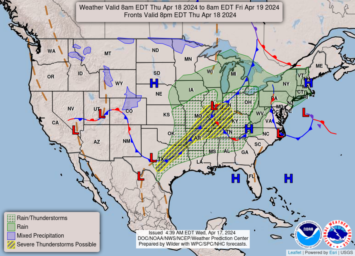
No tornado watches were in effect, according to the National Weather Service's prediction center, but residents have been warned that "a few" twisters could "perhaps" form.
The National Weather Service said in an update on X: "Strong to severe thunderstorms capable of damaging wind gusts, large hail, and perhaps a couple tornadoes, are likely Thursday from parts of the lower Ohio Valley into the southern Plains.
"Further north, a warm front will bring areas of rain showers to portions of the Great Lakes and Northeast U.S."
Expanding in an alert on their website, the service said: "A line of strong to severe storms will impact the Ozarks, mid Mississippi Valley and lower Ohio Valley this afternoon and evening, with wind damage, isolated large hail and a few tornadoes.
"Scattered to widely-scattered storms with a large hail and wind-damage threat will also be likely in parts of the Ark-La-Tex and southern Plains."
Heavy rain is also expected north of the severe alert area, stretching east as far as Vermont and New Hampshire and west to Iowa and Wisconsin.
Forecasters expect the wet weather in the Midwest and Northeast to remain for the next few days. Sunshine is then expected for the weekend across most of the region.
It comes after Ohio was hit severely by thunderstorms Wednesday, with residents in the town of Bucyrus reporting damage to homes and trees blown down.
But amid the storms and wet weather to the north, a heatwave is sweeping the Southeast, producing summerlike temperatures.
North Carolina and Florida are expected to see near-record high temperatures over the next few days, reaching 90 degrees in some areas.
Uncommon Knowledge
Newsweek is committed to challenging conventional wisdom and finding connections in the search for common ground.
Newsweek is committed to challenging conventional wisdom and finding connections in the search for common ground.
About the writer
To read how Newsweek uses AI as a newsroom tool, Click here.