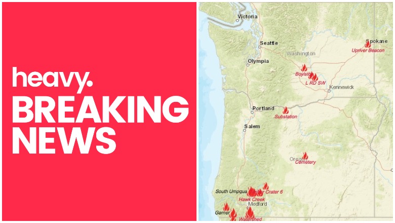
NIFC Oregon Washington fires near me
Here are the latest updates about fires in Oregon and Washington as of the evening of July 21, including the fast-growing John Belmont Fire. You can see an interactive map of the Oregon and Washington fires here, provided by Oregon.gov, or view an interactive map from NIFC.gov here. Another interactive map is here. Read on for details about active fires in Oregon and Washington as of July 21.
Boylston Fire
This Washington fire is 5,000 acres and 10 percent contained, however newer sources are indicating that it is now 80 percent contained. It’s 13 miles east of Ellensburg. The cause is under investigation. One structure is threatened, one damaged, and five destroyed. Huntinger Road in Vantage is closed.
Buckshot Fire
This Washington fire is 1,200 acres and 50 percent contained. It’s 2 miles south of Mattawa. It was caused by human activity. 75 residences are threatened and three minor structures were destroyed.
Cemetery Fire
This fire is 1,414 acres and 85 percent contained, according to NIFC. It’s 32 miles southeast of Prineville. The cause was lightning. It’s burning along the northeast border of the Ochoco National Forest’s Maury Mountains, on a privately owned ranch. Estimated containment date is July 31. The location is 44.08 latitude, -120.204 longitude.
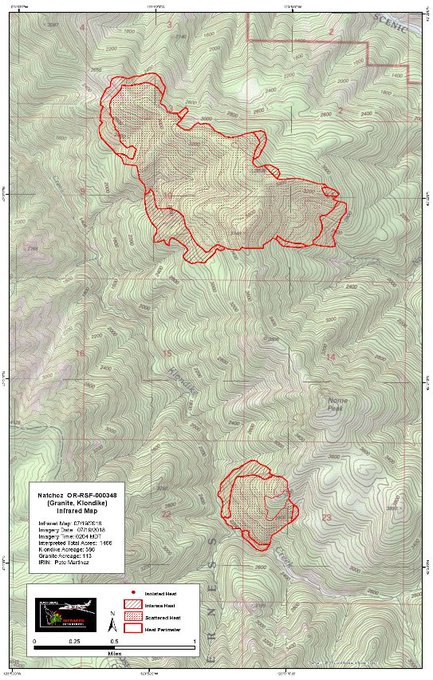
Granite Fire
#NatchezFire, #KlondikeFire, and #GraniteFire IR maps are now available on @inciweb at t.co/vqakpHocvV. IR flights resulted in acreage for each fire as:
Natchez: 767 ac
Klondike: 586 ac
Granite: 113 ac

This Oregon fire is 671 acres and 0 percent contained. It is nine miles northwest of Selma. Twelve residences are threatened.
Hendrix Fire
This fire began on July 15 and was caused by lightning. It’s 950 acres and 15 percent contained, according to NIFC. It’s 10 miles southwest of Ashland, Oregon. It’s along the border of the Oregon Department of Forestry lands and Rogue River-Siskiyou National Forest lands near Hells Peak. You can also get updates here.
The #Hendrixfire acreage has been updated based on the overnight infrared flight. The new fire acreage is 947 acres and containment is at 15%.

John Belmont Fire / Spokane Valley Fire
View of #JohnBelmontFire near Spokane. I’m above it on Mica Peak. Good amount of spread and wind push in last 20 minutes. Can see two planes dropping water (or retardant)

It’s not on the official map, but a fire in Spokane Valley sparked today and has grown quickly. Evacuation orders have been issued.
#JohnBelmontFire LEVEL 3 Evauation Information: Belmont/Chapman NORTH to Chapman/Linke. EAST Across Linke to Saltese Lake Extension Rd: SOUTH on Saltese Lake Extension WEST to Belmont.
The John Belmont Fire is burning in Spokane County near Valleyford. A Level 3 evacuation order was put in place tonight for the fire located on Highway 27 near the Belmont and Jackson intersection.
Firefighters from 8 different fire departments currently engaged in fire attack and protecting homes on #JohnBelmontFire in Fire District 8.
Picture from KXLY News Facebook page

Klondike Fire
This Oregon fire is 2,169 acres and 0 percent contained. It’s nine miles northwest of Selma and 12 residences are threatened.
L RD SW Fire
This Washington fire is 23,900 acres and 60 percent contained. It’s nine miles southwest of Mattawa. It was caused by human activity. Fire activity is moderate with creeping activity.
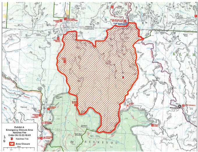
Natchez Fire
A smoke outlook has been created #Hendrixfire #Garnercomplex #Natchezfire
t.co/sknmstuyjb
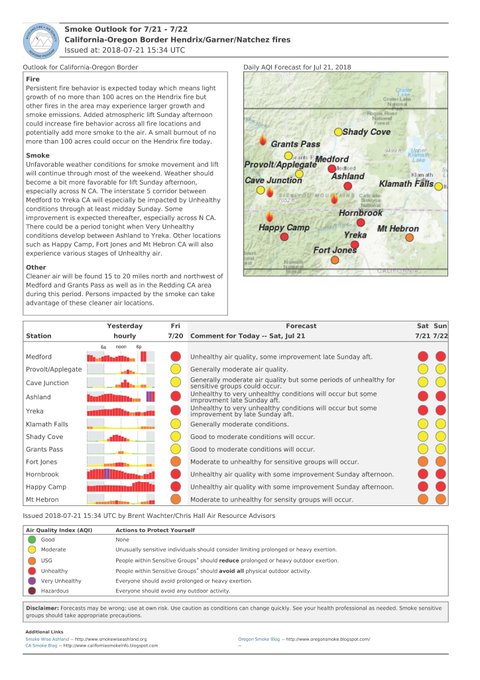
This fire is 1,048 acres and 0 percent contained, according to NIFC. It’s 15 miles southeast of Cave Junction. Get updates here. A total of seven fires are includes as part of this fire event.
#NatchezFire AREA EMERGENCY CLOSURE FOR PUBLIC HEALTH AND SAFETY
Details here: t.co/RQEbWeE2i7
South Umpqua Complex Fire
This Oregon fire is 2,229 acres and 10 percent contained. It’s 30 miles southeast of Myrtle Creek. Six residence are threatened. According to NIFC: “The Umpqua National Forest has issued an Emergency Fire Closure for several trails and roads on the Forest. In an effort to strengthen defenses along the upper flank of the Miles Fire, two hotshot crews spent the night burning out fuels between the established line and the approaching fire. Progress was made, but limited by higher night-time relative humidity which kept the fine fuels from carrying the fire.”
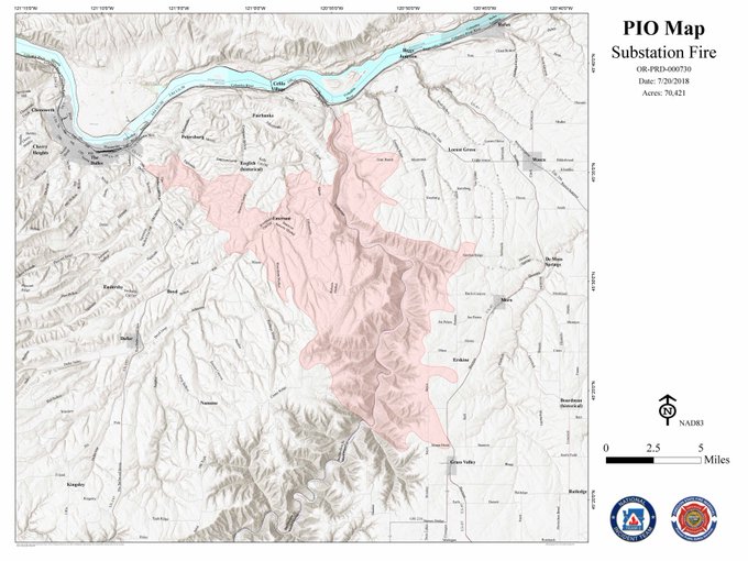
Substation Fire
NEW – No red! #substationfire crews sharing this map of reduced evacuation levels #fox12
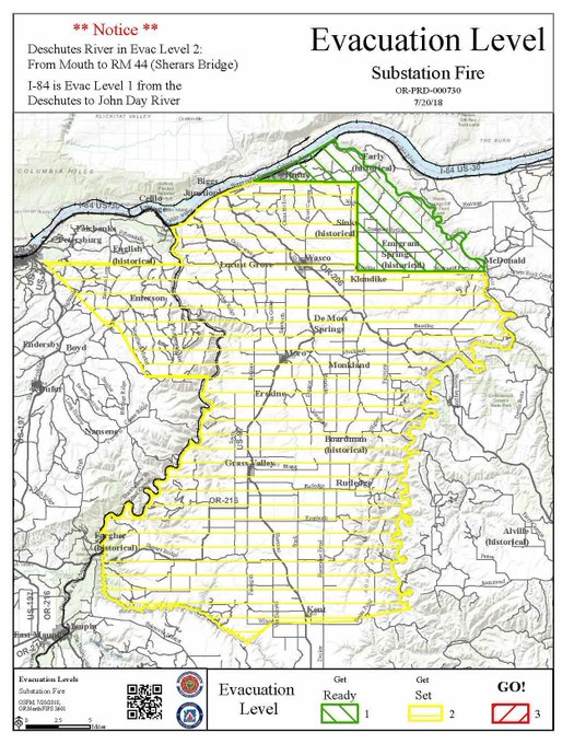
This Oregon fire is 80,763 acres and 44 percent contained. It’s five miles south of The Dalles. The cause is under investigation. More than 1,000 residences are threatened and four were destroyed.
Latest perimeter map for the #SubstationFire
Sugar Pine Fire
A general overview of the fires included in the management of the #SugarPineFire, located on the High Cascades RD:
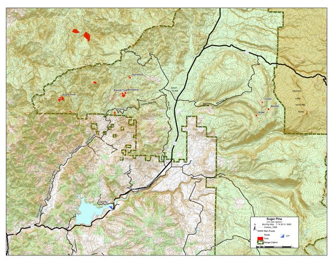
This Oregon fire is 155 acres and 0 percent contained. It’s 12 miles northwest of Prospect. This is the collective name for 19 fires in the area (and also the name of one specific fire.)
Timber Crater 6 Fire
UPDATE: #TimberCrater6Fire Saturday, July 21
NW Team 9 is implementing a strategic plan to safely suppress the fire while ensuring minimal impact on recreation for park visitors and to preserve the natural beauty for which the park is known.
@CraterLakeNPS @FremontWinemaNF
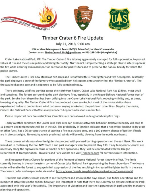
This Oregon fire is 780 acres and 0 percent contained. It’s 20 miles southwest of Chemult and eight miles southeast of Diamond Lake, Oregon.
Union Fire
This Oregon fire is 104 acres and 0 percent contained. It’s 10 miles northeast of Prospect.
Upriver Beacon Fire
Final Update for the #UpriverBeaconFire
@NEWIMT and @SCFD9 thank the community for their support of the firefighters during the fire suppression effort.

This Washington fire is 116 acres and 90 percent contained. It’s 3 miles southeast of Spokane. More recent numbers may indicate it is 100 percent contained.
Wagner / Garner Complex Fire
The fires total about 3,635 acres and 8 percent contained, caused by lightning, according to NIFC. Technically this refers to multiple fires: Wagner Creek is in Jackson County and Garner Complex is in Josephine County.