Weather
Tropical Storm Michael Prompts High Wind, Flood Warnings
Winds and flash flooding are concerns as Tropical Storm Michael moves northeast toward Maryland.


MARYLAND — As Tropical Storm Michael moves northeast, the National Weather Service has put parts of Maryland on alert for flooding and strong winds. Various warnings, watches and advisories have been issued, from central Maryland to the Eastern Shore.
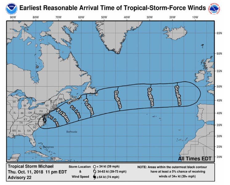
As of 11 p.m. on Thursday, Tropical Storm Michael was 15 miles northeast of Norfolk, Virginia, according to the National Hurricane Center.
Michael is believed to be responsible for at least two deaths – one in Florida and another in Georgia. The governor of Virginia declared a state of emergency to prepare for strong winds and possible flooding there.
Find out what's happening in Baltimorewith free, real-time updates from Patch.
In central Maryland, flooding and strong winds are possibilities overnight into Friday morning; and parts of the Chesapeake Bay are under storm and gale warnings through Friday.
Southern Maryland
Find out what's happening in Baltimorewith free, real-time updates from Patch.
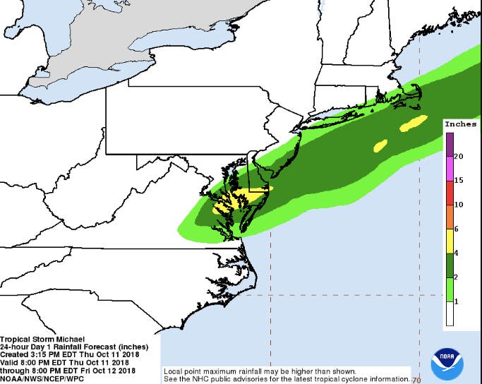
Calvert, Charles, Prince George's and St. Mary's counties are under a flood warning until 4:15 a.m. Friday. About 2 to 4 inches of rain had fallen, with some localized amounts of 4 to 6 inches, officials said, based on the radar. About 1 more inch of rainfall was possible overnight.
Numerous roads were closed due to high water in St. Mary's and Charles counties before 11 p.m. Thursday, according to the National Weather Service, which cited 911 call center data.
Alert Prince George’s Co: High water closes MD 381 in both directions between Dr Bowen Rd & St Phillips Rd. sf #mdtraffic #MDOTNews
— MD State Highway Adm (@MDSHA) October 12, 2018
Drivers should turn around if they come across flooded roads. Turn around; don't drown.
These areas may experience flooding, officials said: Lexington Park, Chesapeake Ranch Estates, La Plata, Chesapeake Beach, Leonardtown, Prince Frederick, Piney Point, Tall Timbers, Saint Inigoes Creek, Hallowing Point, Saint Leonard Creek, Town Creek,, Sheridan Point, Saint Clements Bay, Saint Marys City, Greenwell State Park, Breezy Point, Wicomico River, Saint Mary's River and White Point Beach.
Eastern Shore
Radar indicated 2 to 3 inches of rain had fallen by 11 p.m. Thursday, with 1 to 3 more inches possible on the Eastern Shore, according to the National Weather Service. Flash flooding was expected to begin around 11 p.m. in Somerset, Dorchester and Wicomico counties, which are under a flash flood warning until 5 a.m. Friday. Flash flooding, or a rapid rise in water level, can be life-threatening. In addition, a high wind warning calls for gusts up to 60 mph on the Eastern Shore until 6 a.m. Friday.
Northeastern Maryland
A flood advisory has been issued for Cecil, Kent and Queen Anne's counties until 2 a.m. Friday. Minor flooding is possible in Elkton and Chestertown.
Central Maryland
Baltimore, Harford, Howard, Montgomery and Prince George's counties are under a wind advisory until 6 a.m. Friday. Strong winds may blow down tree limbs and power lines, with the strongest gusts expected late in the evening and in the overnight hours. Winds will be 20 to 30 mph with gusts up to 50 mph, the advisory states. Scattered power outages are expected.
Much of the state is also under a flash flood watch. A flash flood watch means that there is potential for heavy rain in a short time that may lead to flash flooding. Roads, poorly drained areas, creeks and streams are particularly susceptible. Officials said about 2 to 5 inches of rain were expected Thursday.
A flash flood watch is in effect from 2 p.m. Thursday to 6 a.m. Friday for these areas:
- Anne Arundel County
- Baltimore City
- Baltimore County
- Calvert County
- Caroline County
- Cecil County (flash flood watch ends at 5 a.m. Friday)
- Charles County
- Harford County
- Kent County
- Prince George's County
- Queen Anne's County (flash flood watch ends at 5 a.m. Friday)
- St. Mary's County
- Talbot County (flash flood watch ends at 5 a.m. Friday)
Chesapeake Bay
On Maryland waters, a storm warning is in effect from 6 p.m. Thursday to 6 a.m. Friday for the Chesapeake Bay from North Beach to Drum Point. During a storm warning, recreational boaters should remain in port until winds and waves subside because winds of 48 to 63 knots are imminent or occurring.
A gale warning is in effect from 6 a.m. to 6 p.m. Friday on the Chesapeake Bay, meaning winds of 34 to 47 knots are occurring. Recreational boaters should seek harbor before gale conditions hit.
- Virginia Governor Declares State Of Emergency As Michael Approaches
- Hurricane Michael Hits Georgia: Child Killed; 320K Without Power
- Weakened Michael Leaves Trail Of Destruction; To Wallop Carolinas
EARLIER FORECAST — The National Weather Service has issued a flash flood watch for much of Maryland Thursday afternoon as Tropical Storm Michael approaches. Several inches of rain are in the forecast.
The flash flood watch in Maryland calls for rain to be heaviest Thursday afternoon through Thursday night. Officials say about 2 to 5 inches of rain are expected, an increase from the 1 to 3 inches previously forecast.
Up to 6 inches of rainfall may occur in southern Maryland, where officials say an isolated tornado or waterspout may occur Thursday afternoon or evening.
Moisture from the storm will interact with a cold front moving through Maryland Thursday, leading to heavy rain, with the highest amount projected in the southern part of the state, weather officials say.
As of 2 p.m. on Thursday, Tropical Storm Michael was 40 miles south of Greensboro, North Carolina, according to the National Hurricane Center. Michael is believed to be responsible for at least two deaths – one in Florida and one in Georgia.
"On the forecast track, the center of Michael will continue to move across central and eastern North Carolina today, move across southeastern Virginia this evening, and move into the western Atlantic Ocean tonight," National Weather Service forecasters said Thursday.
Flash flooding, or a rapid rise in water level, can be life-threatening. A flash flood watch means that there is potential for heavy rain in a short time that may lead to flash flooding. Roads, poorly drained areas, creeks and streams are particularly susceptible.
The flash flood watch in Maryland is in effect from 2 p.m. Thursday to 6 a.m. Friday for these areas:
- Anne Arundel County
- Baltimore City
- Baltimore County
- Calvert County
- Caroline County (flash flood watch ends at 5 a.m. Friday)
- Cecil County (flash flood watch ends at 5 a.m. Friday)
- Charles County
- Harford County
- Kent County
- Prince George's County
- Queen Anne's County (flash flood watch ends at 5 a.m. Friday)
- St. Mary's County
- Talbot County (flash flood watch ends at 5 a.m. Friday)
Elsewhere in the state, weather officials say 1 inch of rain is possible.
A breezy and rainy day as T.S. Michael tracks to our south. Rain will continue through the day, turning heavy at times. Highest totals will be over portions of Delmarva and SE NJ. A Flash Flood Watch goes into effect for much of the area at 2:00 PM. #PAwx #NJwx #MDwx #DEwx pic.twitter.com/WogaZWvrmg
— NWS Mount Holly (@NWS_MountHolly) October 11, 2018
A wind advisory is in effect for Saint Mary's and Calvert counties from 6 p.m. Thursday to 6 a.m. Friday. Up to 50-mph wind gusts will be possible, leading to the potential for downed trees, fallen power lines and scattered power outages.
For the latest weather updates, get Patch news alerts, the free Patch iPhone app or free Patch Android app.
See a map of weather warnings from the National Weather Service.
Image via National Weather Prediction Center.
Get more local news delivered straight to your inbox. Sign up for free Patch newsletters and alerts.


