At a Glance
- Two tropical cyclones are spinning in the western Indian Ocean.
- A third tropical cyclone has made landfall in Somalia.
- The North Indian Ocean is seeing one of its most active seasons on record.
- Well-above-average ocean temperatures are helping cyclones form.
The tropics are crowded once again during this record season in the Indian Ocean as a phenomenon similar to a strong El Niño keeps waters warm near Africa.
Three hurricanes – or tropical cyclones, as they are called in that part of the world – were located in the western Indian Ocean; two are still active in the southern Hemisphere.
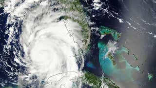
- Tropical Cyclone Belna is intensifying north of Madagascar, and could strike the Comoros and Madagascar as the equivalent of a major hurricane, Category 3 or higher, early in the week ahead. Heavy rain, flooding and strong winds are concerns.
- Tropical Cyclone Ambali is spinning well to the east of Madagascar and is weakening. It is not expected to threaten land before dissipating. Ambali rapidly intensifying by 115 mph in 24 hours, making it the most rapid intensification in a 24-hour period in the Southern Hemisphere by a name storm on record and the second most rapid intensification globally. It also reach the equivalent of a strong Category 4 hurricane.
- Tropical Cyclone Pawan (locally, Cyclonic Storm Pawan) was a weak system that made landfall in Somali early Saturday, local time. It will bring increased moisture and possibly heavy rain and flooding to Somalia and other parts of eastern Africa into this weekend.
(MORE: What Tropical Cyclones Are Called Around the World)
Pawan spun in the opposite direction as the pair of cyclones Belna and Ambali to the south.
Each cyclone’s spin depends on where it is in relation to the equator. Tropical cyclones spin counterclockwise north of the equator, while their Southern Hemisphere counterparts rotate clockwise.
The Indian Ocean is one of the few basins that can host both types of cyclones this time of year. Most other Southern Hemisphere basins are either too cold or the atmosphere is too inhospitable for tropical cyclones.
What's Made the Indian Ocean So Ripe for Cyclones
This week's tropical cyclone triplets have been spawned by an intersection of very favorable climate and weather conditions.
First, the part of the world where these cyclones have spun up is experiencing something akin to El Niño in the Indian Ocean – the positive mode of a feature called the Indian Ocean Dipole (IOD).
The positive IOD has spread far-above-average water temperatures over much of the western Indian Ocean and Arabian Sea. These warmer waters are not only more favorable for hurricane development – they also support increased rainfall for parts of eastern Africa.
You can find more on the Indian Ocean Dipole in the next section.

Another strong climate pattern has assisted these cyclones: A favorable phase of the Madden-Julian Oscillation, or MJO, is sweeping eastward across the Indian Ocean.
The MJO is an atmospheric disturbance of clouds, rain, wind and pressure in the tropics that propagates eastward around the globe over a period of 30 to 60 days.
Tropical cyclones can more easily form, develop and intensify when the enhanced phase of the MJO swings across an ocean. Typically, half of the planet will see an upward swing in rainfall while the other half will see drier conditions.
(MORE: The MJO's Impact on Hurricane Forecasts)
This wave of enhanced rising motion is expected to arrive in the Bay of Bengal and eastern Indian Ocean toward mid-month, meaning we could see more cyclone activity in those regions.
Local weather and oceanic conditions have also been favorable for cyclone development in the western Indian Ocean. Wind shear – the change in winds with altitude – is light to moderate for now, humidity around each cyclone is high and, as mentioned before, water temperatures are above average.
More on the Indian Ocean Dipole
Much like the El Niño/Southern Oscillation, the IOD features a semi-cyclic sloshing of warm water across the Indian Ocean. When the IOD is positive, unusually warm water extends westward into the Arabian Sea, while the waters near Southeast Asia and Australia are cooler than average.
October's near-record IOD index makes 2019 one of three years in records going back to 1982 to see a monthly IOD value above +2.0°C.

"IOD usually manifests first around early summer and strengthens to a peak in late-fall," Dr. Saji N Hameed, a professor at Japan’s University of Aizu and one of the world’s leading experts on IOD, told weather.com India in September.
The current IOD is also following this pattern, which reached peak warmth in October, but has since started to cool off. The pattern remains strongly positive with far-above-average ocean temperatures near Africa and far-below-average water temperatures near Indonesia.
(MORE: Indian Ocean Dipole Questions Answered)
Like El Niño, this dipole is known to disrupt or amplify precipitation patterns in its different phases.

In September, Hameed warned that this phase of the IOD could bring flood issues to eastern Africa before the waters cooled off.
This fear was realized in October and November.
Rainfall from October to mid-November was as much as 300% above average across the Horn of Africa, according to the Famine Early Warning Systems Network. The areas hit hardest include parts of Ethiopia, Somalia and Kenya. The increased rainfall and its resulting flooding has killed at least 250 and has displaced millions more.
On the opposite end of the spectrum, the dipole is known to cause drier-than-average conditions for Southeast Asia and Australia.
More than 7,000 fires have burned across Australia’s New South Wales state since July. The combined burn area from these fires is roughly the size of Hawaii’s land area.
The Indian Ocean’s Hyper-Busy Cyclone Season
The northern Indian Ocean, which includes the Bay of Bengal and the Arabian Sea, has been on a pace that rivals or even exceeds the extreme pace of tropical storms and hurricanes set by the 2005 Atlantic hurricane season, which is widely regarded as one of the most extreme seasons anywhere in the world.
So far in 2019, there have been a record six "very severe cyclonic storms," which are roughly equivalent to a Category 1 hurricane in the Atlantic. This compares to an annual average of one to two of these storms.
In terms of Accumulated Cyclone Energy (ACE), the North Indian Ocean has had nearly 88 units through Dec. 4. That is nearly five times the average of about 18 through that date.
ACE is the sum of the energy produced by wind for each storm and takes into account the number, strength and duration of all the tropical storms in the season.

For reference, the 2005 Atlantic Hurricane Season had 15 hurricanes, much higher than the average of six. It had an ACE of 250 units, or nearly three times the average of 88.
Unlike most oceans in the world, the northern Indian Ocean has a hurricane season that has two peaks in activity. The Atlantic season has one peak, in September.
The two peaks are in May and in October, or on either side of the Indian monsoon.
(MORE: Why the Tropical Cyclone Season Peaks Twice in the Indian Ocean)
As the monsoon peaks during the summer, upper-level winds in the northern Indian Ocean become too brisk for strong tropical cyclones to develop. Instead, weak monsoon depressions, or low-pressure systems, with heavy rain form at times.
Typically, right before the monsoon kicks in (April through June) and just after it fades (September into December), there is a window when vertical wind shear relaxes enough for possible strong tropical cyclone development in the northern Indian Ocean.
Although there are preferred time frames, tropical cyclones can form at any point in the year in the Indian Ocean.
The Weather Company’s primary journalistic mission is to report on breaking weather news, the environment and the importance of science to our lives. This story does not necessarily represent the position of our parent company, IBM.