


Pair the words “California” and “scenic drive” and travelers think of ocean views along the popular Pacific Coast Highway. But road trippers breaking free from COVID-19 isolation and seeking a road less traveled find a quieter side to California on the other side of the mountains running down its spine.
Wild West rodeos and ghost towns. Snow-capped peaks and hot springs. Surreal landscapes with calcite towers standing in a salt lake and a boulder-strewn desert where movie-star cowboys galloped in Westerns.
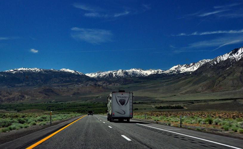
On U.S. Highway 395, motorists encounter America’s highs and lows as they travel along the eastern flank of the Sierra Nevada Mountains. Mount Whitney, the tallest peak in the lower 48, rises on the west while North America’s lowest point dips to the east in Death Valley. And they experience a historical low point as well, a Japanese internment camp from World War II.
People are also reading…
What they are unlikely to encounter are crowds. When my husband and I hit the road in mid-June last year we drove on long stretches of highway with only another car or two in sight.

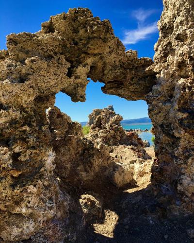
Weird calcite formations, known as tufa, form along the shoreline of Mono Lake when salty lake water mixes with fresh water springs.
U.S. 395 was just a dirt trail prospectors called El Camino Sierra when they traveled it during the Gold Rush. Now a State Scenic Highway, signs bearing the state flower, the poppy, mark the route skirting almost the entire length of California’s backbone.
We picked up the route in a broad valley near Bridgeport, south of Lake Tahoe near the Nevada border. We passed rodeo grounds and old-timey storefronts on our way to a charming ma-and-pa motel. We ended our journey in another old-school motel in Lone Pine about 150 miles south. Yes, we could have driven the route in less than a day, but instead we took five to make detours and build in experiences along the way.
Wild West ghost town
Our first detour took us to Bodie, 13 miles off U.S. 395 — the last three gravel— to a ghost town left in a state of “arrested decay.” I peeked through dusty store windows to see shelves stocked with goods a century old. We hesitated to stand too close to some buildings, the wood burnished bronze by the unforgiving climate of the high desert, fearing they might fall over at any moment. Now a state park, Bodie had 60 saloons and dance halls when gold and silver mining peaked in the 1870s. Gunfights broke out and the bordellos stayed busy. One preacher described it as “a sea of sin, lashed by the tempests of lust and passion.”

The ghost town of Bodie, Calif., remains in a state of “arrested decay” with century-old merchandise left on store shelves.
No tempests stirred Mono Lake, but its Dr. Seuss-like calcite formations seduced my imagination. Almost three times as salty as the ocean, the lake water mixes with fresh spring water forming weirdly shaped tufa up to 30 feet tall along the shoreline.
We first spotted Mono from a vista point on U.S. 395 high above the town of Lee Vining, then followed the road down to the Whoa Nellie Deli. Housed inside a Mobil gas station, it’s more than a place to grab a quick bite while refueling. Two outdoor wedding receptions kept the cooks busy on the Friday night we were there for ribs and fish tacos.
The next day we detoured onto the June Lake Loop, a scenic route linking four jewel-like lakes. A two-mile hike around Gull Lake let us stretch our legs and gawk at Carson Peak rising nearly 11,000-feet above aspen and pine forests.
Mountains and lakes
Mammoth Lakes, a popular ski resort town in winter and scenic playground in summer, merits two days to explore its geological wonders. Gondolas climb to the summit of Mammoth Mountain, 11,053 feet, year-round to nature exhibits inside the aptly named Eleven53 Interpretive Center. From this perch, I spotted Minaret Vista, a rock face resembling a picket fence, across the valley and watched skiers launch themselves down the mountain. The runs often stay open until July 4.
I transitioned from the cold of the mountaintop to the heat of Hot Creek Geological Site where steam vents and scalding turquoise pools hint at the region’s volcanic origins. Signs warn “No Swimming.” No kidding.

Crystal Crag pokes above the mountains surrounding Mammoth Lakes Basin.
Summer visitors safely swim in Convict Lake, named for an 1871 prison break that ended badly for both outlaws and lawmen. Anglers go after trout, buying California fishing licenses and renting gear and boats at the marina. At Mammoth Lakes Basin, five lakes are strung along the road. I got out at Lake George to snap an Instagram-worthy shot of Crystal Crag mirrored on its surface.
One regret: The road to Devils Postpile National Monument hadn’t opened for the season, so we missed seeing its hexagonal basalt columns and Rainbow Falls dropping 101 feet over a lava ledge.
Highs and lows
We continued driving south on scenic U.S. 395, the summits of the Sierra rising on our right. A well-maintained road, sometimes two-lane, sometimes four, it dipped and curved but not dangerously so. We encountered little traffic passing through Bishop and Independence.
The jarring sight of a guard tower and barbed wire had us pulling over at Manzanar National Historic Site, one of 10 military-style internment camps imprisoning Japanese-Americans during World War II. A sad chapter in American history, President Ronald Reagan called it “a mistake” when signing a law authorizing modest reparations to camp survivors. A self-guided driving tour took us to reconstructed barracks where some of the 10,000 held here lived. A white obelisk stood sentinel in the cemetery.

Barbed wire and guard towers mark the perimeter of Manzanar National Historic Site, a Japanese internment camp off U.S. Highway 395.
In Lone Pine, our hearts lightened at the Museum of Western Film History exhibits of movie props, costumes, posters, saddles — even a full-size stagecoach. A five-mile detour from U.S. 395 took us to Movie Road winding through the Alabama Hills, a 30,000-acre desert where more than 400 films and TV shows have been filmed since the 1920s. Its smooth reddish-brown boulders formed the background in old-time Westerns starring the Lone Ranger, Roy Rogers and Hopalong Cassidy as well as movies such as “Django Unchained,” “Gunga Din,” “Star Trek Generations” and the horror film “Tremors.” We stopped to follow a trail led to Alabama Hill’s must-see natural attraction, Mobius Arch, a weathered 8-foot rock formation framing the jagged granite peaks of the Sierra behind it.

Mobius Arch frames the Eastern Sierra Nevada Mountains in the Alabama Hills near Lone Pine, Calif.
Those peaks loomed ahead as we continued our detour seven more miles on Whitney Portal Road to the trail leading to the top of Mount Whitney, highest in the contiguous U.S. states. A permit is required for the 22-mile round-trip climb to the summit, 14,505 feet with an elevation gain of more than 6,000 feet.
Whitney Portal Store, a hostel, camp store and snack bar known for burgers and pancakes, felt high enough at 8,360 feet. We drove back down, marveling at the view from hairpin turns of the broad valley below. U.S. 395 snaked north and south and we could just make out the road to Death Valley National Park, and the lowest point on the continent, disappearing through mountains to the east. Our next adventure.
Driving U.S. 395
Best time to go: June through Oct. 31. Some roads off U.S. 395 close in winter.
Lodging: Approximate starting rates in mid-August
Walker River Lodge, Bridgeport, from $130, 1-800-688-3351, walkerriverlodge.com
Sierra Nevada Resort & Spa, Mammoth Lakes, from $149, 1-800-824-5132, thesierranevadaresort.com
Best Western Plus Frontier Motel, Lone Pine, from $135, 1-800-780-7234, bestwestern.com
California travel
Driving down California's backbone

California’s Alabama Hills, named for a Confederate war ship, have served as the backdrop for more than 400 movies and TV shows.
Driving down California's backbone
Mobius Arch frames the Eastern Sierra Nevada Mountains in the Alabama Hills near Lone Pine, Calif.
Driving down California's backbone
Weird calcite formations, known as tufa, form along the shoreline of Mono Lake when salty lake water mixes with fresh water springs.
Driving down California's backbone

Boiling springs are off limits to swimmers at Hot Creek Geological Site.
Driving down California's backbone
Barbed wire and guard towers mark the perimeter of Manzanar National Historic Site, a Japanese internment camp off U.S. Highway 395.
Driving down California's backbone

An obelisk with Japanese letters marks the cemetery at Manzanar National Historic Site, a World War II internment camp.
Driving down California's backbone

Scenic U.S. Highway 395 follows the flanks of the Sierra Nevada Mountains in eastern California.
Driving down California's backbone
Crystal Crag pokes above the mountains surrounding Mammoth Lakes Basin.
Driving down California's backbone

Guard towers still stand along the grounds of Manzanar where 10,000 Japanese-Americans were wrongly imprisoned during World War II. Photo by Katherine Rodeghier
Driving down California’s backbone
The ghost town of Bodie, Calif., remains in a state of “arrested decay” with century-old merchandise left on store shelves.
Driving down California's backbone

A detour from U.S. Highway 395 leads to tufa, calcite formations, along Mono Lake. Photo by Katherine Rodeghier
Driving down California's backbone

Weird calcite formations, known as tufa, form along the shoreline of Mono Lake when salty lake water mixes with fresh water springs.
Driving down California's backbone

U.S. Highway 395 runs along the backbone of California, the Sierra Nevada Mountains. It is a State Scenic Highway.
Driving down California’s backbone

Bodie State Historic Park, a ghost town in the high desert along the Eastern Sierra, once had 2,000 buildings. Only a handful remain.


