
It was in the spring of 1849, one year after the “birth” of Wisconsin on May 29, 1848. Hernander Anderson, a deputy surveyor working under the Surveyor General George B. Sargent’s office in Dubuque, Iowa, prepared the first map of Section T/ 27 N-R 13 W. in Dunn County.
He recorded the route of the Red Cedar River, the creeks, swamps, Indian trails — but had only two sites of human habitation. One was Andrew Tainter’s logging operation at the mouth of Varney Creek; the other was Stone’s Trading Post a mile upstream from present-day Downsville.
So the village of what eventually became known as Downsville was first established on June 22, 1855, when “Ebenezer Thompson built a small sawmill, cutting a short ditch across the bend in the Red Cedar River, and using this ditch as a mill race. But high water soon enlarged the ditch until it became the main channel.”
People are also reading…
‘Deed’ was done
Three years later, on Feb. 24, 1824, Thompson deeded his interest in the mill to Burrage B. Downs who built a dam across the river at this point, thus giving a name to the location.
In May 1859, Mr. Downs and Ebenezer Thompson called for a survey of the area and a plat included 22 blocks, “whole and fractional in Sections 35 and 35”, illustrated in this partial map. According to the 1925 History of Dunn County, “…a second plat was recorded on January 7, 1861, of 20 blocks, whole and fractional, was made for Burrage Downs.” Then on March 5, 1883, another plat of the village was made by the county surveyor, D. W. Waite, the county surveyor.
I’ve never found any reference to the date when the Knapp, Stout & Co. Company purchased the property from Mr. Downs. It would take some investigation to learn that, but be assured that Knapp, Stout was successful in “buying out” any rival logging operation, big or small, on the Red Cedar River from its source, Red Cedar Lake in Barron County to its mouth on the Chippewa River below the village of Dunnville. For instance, there were no less than four rival logging operations at Cedar Falls before the Knapp, Stout & Co. Company purchased the rights to operate there.
So the acquisition of the Downsville operation signaled the enlargement and improvement of the mill, “increasing its capacity to 100,000 board feet in a day of eleven hours.” The Knapp, Stout & Co. Company added “planning and shingle mills in connection with it and gave employment to about 100 men, keeping a boarding-house. which was managed for them by S. C. Rogers.”
Big wash-outs
“In 1883 there occurred a great flood which washed out the dam and railway tracks, and the Knapp-Stout people, then operating under the name of the Knapp, Stout & Co. Company, got Captain Downs, who was a man of good constructive ability, to come back and repair the damage.”
According to the source, the History of Dunn County, that flood was usually referred to as “The second big washout.”
In September 1900, Knapp, Stout & Co. Company was in the final steps of closing its logging operations in Wisconsin, and in that year closed the Downsville mill operations.
Five years later, on June 7, 1905, what became known as the “third big flood” on the Red Cedar River, reached the “highest point ever knows”. It washed out and “carried away the railway bridge, washed out the east side dam and the banks of the river to within 30 feet of the lumber office and took away a part of the lumber yard.
That flood ended any possibility of a major lumber mill operation on the site. The railroad, operated by the Milwaukee Road, was rebuilt and continued to operate up until the early 1960s. Its former roadbed is now the site of the Red Cedar Trail. About the only “survivor” touched by the flood was the wagon bridge that crossed the river at Downsville.
*All quotations are from the 1925 History of Dunn County.
John Russell, a local photographer and Dunn County resident, writes a weekly column for The Dunn County News. He is curator emeritus of the Dunn County Historical Society.
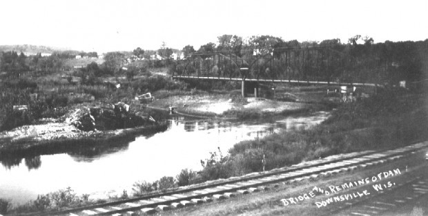
SUBMITTED PHOTOS / For Dunn County News
DC_0701_A2_Russell-photo:
After the flood, an unidentified photographer setup his camera on the bluff overlooking the former site of the Knapp, Stout mill and dam and caught this view of the damage. There is nothing of the sawmill remaining. A mound of debris on the river’s edge to the left of center is all the remains of the dam that had formed the old mill pond where the logs were stored, awaiting the saws.
Yes, the railroad track in the foreground still appear to be intact, but a few long stretches of the rail line, to the left and right, were wiped out by the flood waters and had to be rebuilt.
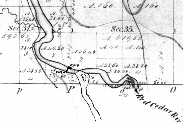
DC_0701_A2_Russell-map:
This detail map is from the 1847 original drawing. I have superimposed the change in the course of the Red Cedar River after the first settler in the area, Ebenezer Thompson, “cut a short ditch across the bend of the river as a mill race, but high water soon enlarged the ditch until it became the main channel.” That is still route of the river today, and remnants of the original course still remain east of the village. Please note that the dam shown here was built later, in 1858, by Burrage Downs.