
Here's what Antarctica's calving glaciers look like up close
The Thwaites Glacier is often considered one of the most important when it comes to changes in sea level, but it has been little studied. A new expedition hopes to change that.
AMUNDSEN SEA, ANTARCTICA — After a month of sailing the great Southern Ocean, during which there was a nine-day medical evacuation, after a few days digging ditches on a remote island chain searching for ancient penguin bones, after the sea sickness medications and the seal tagging, the test missions of the Autonomous Underwater Vehicle (AUV) and the start of an international ping pong tournament, after all that the R/V Nathaniel B Palmer and the fifty-six people who currently call this sturdy ship home, arrive at our destination: Thwaites Glacier. The night prior I woke occasionally in eager anticipation, each time opening my polyester curtain to see if I could make out the ice front through the fog. Finally, at five, I pull on multiple layers of long underwear and head to the bridge where, in the gloaming, a few others had gathered to cast their gaze on the great glacier’s seaward edge, a view that no human being had ever before seen.
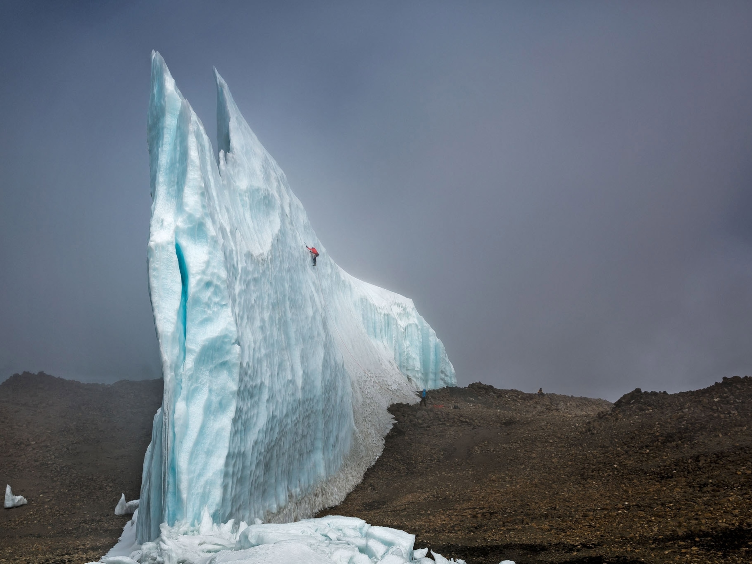
For a while we speak in hushed tones, as though we are in a roofless cathedral. A wild line twists along the top of the ice front drawing torqued gorges into the blue-white snow. Slabs of compressed ice balance precariously over the sea. Some parts of Thwaites look like a glacier coming undone, while other sections are steep and sturdy and sheer. Over 100 miles long, it takes us hours and hours to sail its length. Throughout the day the scientists and crew members on board cycle through the bridge to take a look.
Those who have spent time at Antarctica’s other iconic ice sheets—Ross Island and Pine Island in particular—note immediately that Thwaites looks different, and not in a good way. Some point to how the ice slumps at the edges, “like snow sliding off a roof,” others call it “mangled,” “gnarly,” and “undulatory.” Each noting how the ice here behaves in unusual ways.
By the end of that first day my heart is sore from being pulled in two different directions at once. On the one hand I am in awe. To glimpse the edge of one of the world’s great glacial systems—Thwaites runs roughly 350 miles inland, growing deeper and taller over the cold distance—is to stand in the presence of what the human mind can’t easily comprehend. Whenever the ice face looms well above the ship, I think about how this is only a fraction of what is here, the wall simultaneously extending as much as 1,500 feet below the sea surface; its mere presence is so immense and immensely foreign it leaves me feeling small and blazingly alive. And yet on the other hand every time I spot a giant rumple in the ice sheet, I think about how actions carried out so very far from this seemingly untouched landscape are likely forcing some of those fissures into the ice face, forcing Thwaites to take on strange, unnatural shapes.
When we talk about the possibility of runaway ice sheet collapse in the era of man-made climate change, Thwaites is the glacier that many folks fear most. Thwaites is so remote that we have next to no observational data close to the ice front: some aerial images and satellite surveys, a mooring that we recovered on this mission from about 100 miles north of the ice shelf, little else. One of the reasons Thwaites is so regularly spoken of as a source of great concern is our ignorance. However, the little we do know points to this particular glacier’s tremendous vulnerability and equally large potential impact on coastal communities the world over.
Much of Thwaites rests below sea level, which means that as warm Circumpolar Deep Water melts it from beneath it could enter into a phase of irreversible retreat, which could in turn destabilize the entirety of the West Antarctic Ice Sheet, causing sea levels to rise as much as twelve feet. How much will Thwaites disintegrate and how fast might all of this come to pass, these are the questions that launched our scientific mission. (Read more about Antarctica’s big meltdown.)
Rewriting the map
For the next couple days things progress more or less as planned. We extract cores of sediment from the ocean floor. We send out a glider (a kind of marine airplane that flies up and down between the ocean bed and the surface of the sea taking measurements in the water column) and deploy an AUV that collects the first samples from beneath the ice sheet. As we scoot around this unnamed bay, carrying out our various experiments we are also always mapping the ocean floor with a sonar system, recording the depth of the troughs that feed warm water under the glacier in the first place.
When I take a step back and compare the real-time map of the seafloor that we are in the process of fleshing out to those we have onboard the ship, I begin to realize that many of them are wrong in startlingly similar ways. Up on the bridge, the paper map of Cape Herlacher and Martha Straight, where we trace our path in faint pencil marks, shows where we currently sail not as open water but as ice. Down in the Marine Technician’s lab, a screen saver on a computer plots our current course as a bright red line drawn on top of the Thwaites Ice Tongue. Just as recently as last year, significant parts of this bay were covered over in land-fast-ice; ice that had long held human beings at arm’s length.

Our fourth morning breaks bright and moody. During the night the ocean has started to freeze over and the glider stopped sending communication pings. We go on a rescue mission to pick it up. Then we head to the area where the submarine was deployed so that we might retrieve the beacons we used to communicate with her while she was beneath Thwaites. When we arrive at the old experiment site what we once encountered as quiet water is now entirely covered over. A kilometer-long iceberg has broken out from the glacier and drifted over the test site. One beacon, it is decided, must be abandoned.
On the boat the days pass in a surreal, never-ending blur. Smear ancient mud on glass slides to search for signs of life. Fill plastic bottles with seawater to test for chlorophyll. Eat at midnight when your shift runs through the midnight hour. Interview scientists and technicians and crew members. Eat. Sleep. Rinse. Repeat.
One afternoon down in the Dry Lab, Rob Larter, the chief scientist, is looking over aerial images of Thwaites that his colleague just sent. He compulsively clicks back and forth between two. The first shows Thwaites’ ice front as a straight line running along the southern margin of the unnamed bay where we have spent most of the last week. In the second image it looks as if someone took a hammer to a piece of glass, shattering it into hundreds of jagged pieces. The first image is from February 28th and the second from March 3rd.
“It is pretty clear there has been a significant release of icebergs from the ice shelf in the area where we were working,” says Larter, fiddling with the zipper on his bright orange jumpsuit. He seems almost bewildered, touches his dry palms to muddy pants. “That looks to be nearly as dramatic as the Larsen B collapse,” he adds referencing the 2002 break-up of a Weddell Sea ice sheet equal in size to my home state of Rhode Island.
I think back over the previous days. It is true that when we first got to Thwaites we had sailed all along the ice front in relatively open water. Then somewhere in the middle of the week things changed. The bay became messy with what I now understand was glacial flotsam: giant tabular icebergs that looked like they could eat our ship for breakfast, bergie bits and growlers surrounded by slush thick with brown diatoms (a single-cell critter that smells like marine funk and provides fuel for much of the food chain down here.) In retrospect I could confirm the story that the satellite image suggested. Large parts of Thwaites’ ice front had broken off while we were there, at ground zero, gathering data. But in the moment, as this was all coming to pass, I hadn’t really noticed the change. With no lived experience of the place it was difficult for me to tease out the difference between the extraordinary and the mundane.
Witnessing a break up
The next day I post on Twitter about how eerie it is to stand at the zero zone while Thwaites is undergoing a massive calving event, an event that many of us onboard barely noticed while it was taking place. There was no giant crash or boom. No thunder noises or tidal waves, as sometimes accompany the breaking apart of ice. That morning, when we were searching for the sea glider and communication beacons, I snapped a few photos of the sun rising over a steady stream of icebergs. In that moment I did not know that I was photographing ice that had, some hours prior, been a part of Thwaites.


The bergs are back-lit, our sun a prism, radiating light. A thread grows beneath my photo, where scientists and various other members of the Antarctic community discuss how to classify what has come to pass: is what we are witnessing at Thwaites a calving event, collapse, or a disintegration? Did the ice front step back or was this a case of wind blowing out already broken off bergs? What was it that we had sailed alongside a few days prior on that first heady morning when everyone was talking about how strange Thwaites looked, was it the ice front or a mélange?
At first, I wondered if perhaps I had mislabeled the scene. But as time ticked on and as we had many of the same discussions on board the Palmer it dawned on me that even the experts did not know how to name what was happening all around us. What do you call it when a glacier discharges icebergs into a bay that does not have a name because no one has ever before been there—because just last year that bay was not bay but ice?

According to the New Oxford American Dictionary, to calve means to give birth to a calf; or to split and shed a smaller mass of ice. One definition describes the moment when an individual animal becomes uniquely itself, it is a moment of pure possibility. Iceberg calving, on the other hand, in the age of our ever-warming planet, carries a completely different valence. It appears as a warning sign, something that is eerie and unnatural, portending a kind of self-inflicted doom.
“Ice has to be calved to become an iceberg,” says Aleksandra Mazur, our resident iceberg expert one morning while we look out over the bay now cluttered with glacial debris. She is pointing to the moment when the iceberg becomes something separate from the ice sheet, something distinct, a floating platform that will likely travel well beyond the farthest edge of the Amundsen Sea. “Calving is a natural process,” she continues. “What might not be natural is the rate at which it is happening, the acceleration of the process. That is where we see what might be our human influence.”
Close to the bow the surface of the water is calm, subdued by the formation of my favorite type of sea ice. There it appears as if the ocean has been taken over by a flotilla of over-sized amoebas or, as they are aptly named, pancakes. Mazur logs her ice observations in the computer devoted to creating a data set that will be used to ground-truth the satellite images. When we are back on dry land we will compare what we saw, hour by hour, with the Sentinel satellite images, searching for the right terms to classify our present condition.
A time of global change
We often talk of the loss of Antarctica’s glaciers as disaster-inducing, the doomsday scenario that could drown entire cities, make a modern-day Atlantis of New Orleans or Miami. We do not yet know just how much of Thwaites will collapse or how fast. However, with each passing day, and each additional ton of carbon and methane pumped into the atmosphere, with the discovery of each additional physical process that might just make the very withdrawal of the ice sheet unstoppable, the predictions tilt higher and higher. Whether we will have two or three feet, six feet or ten of sea level rise by century’s end is still anybody’s guess.
What we do know is that the very rate at which sea levels are rising continues to accelerate and the glaciers that have long held the West Antarctic Ice Sheet in place are starting to come unpinned; meanwhile the most vulnerable among us, far from Thwaites calving edge, already feel the squeeze. Many of our lowest lying communities are currently confronting a coastline whose very shape is changing. We don’t need to tell them about the most recent calving event, they already know.
Along with Thwaites the overwhelming majority of the world’s glaciers have begun to withdrawal. I have even recently read about their disappearance in the news, yet another reality that would have been unthinkable a decade ago. Lately, I have been wondering if it might be possible to think of calving events as both a physical sign of the cracks our very lives press into the ice and also, as the definition suggests, a kind of birth. A rapturous moment where we might glimpse the opportunities that come with inhabiting an age of earth-shaking transformation, transformation that some human beings more than others set in motion, and that we, all of us together, have the power to slow and to shape.

The calving event in the unnamed bay is another sign that Thwaites is giving way, that the very thing we feared might come to pass looks like it might already be underway. The extent to which what follows breeds only further devastation or a shift in how we choose to inhabit the Earth, that much is, at least partially, up to us. Perhaps these bergs peeling away from Thwaites are sentinels urging us towards new politics (enter Flood Forum USA, a nation-wide coalition of flood survivors that are fighting for more just storm recovery, and the Green New Deal, its increasing supporters insisting that equity be chief among its guiding principles), new ways of relating to each other and the more-than-human-world.
On the bridge there is a hand-made sign tacked above the outdated navigational charts. It reads Never forget: The ice is telling you what to do and not you are telling the ice what to do. Thwaites speaks, its calving a message we must now labor to hear.
Related Topics
You May Also Like


Go Further
Animals
- Octopuses have a lot of secrets. Can you guess 8 of them?
- Animals
- Feature
Octopuses have a lot of secrets. Can you guess 8 of them? - This biologist and her rescue dog help protect bears in the AndesThis biologist and her rescue dog help protect bears in the Andes
- An octopus invited this writer into her tank—and her secret worldAn octopus invited this writer into her tank—and her secret world
- Peace-loving bonobos are more aggressive than we thoughtPeace-loving bonobos are more aggressive than we thought
Environment
- Listen to 30 years of climate change transformed into haunting musicListen to 30 years of climate change transformed into haunting music
- This ancient society tried to stop El Niño—with child sacrificeThis ancient society tried to stop El Niño—with child sacrifice
- U.S. plans to clean its drinking water. What does that mean?U.S. plans to clean its drinking water. What does that mean?
- Food systems: supporting the triangle of food security, Video Story
- Paid Content
Food systems: supporting the triangle of food security - Will we ever solve the mystery of the Mima mounds?Will we ever solve the mystery of the Mima mounds?
History & Culture
- Strange clues in a Maya temple reveal a fiery political dramaStrange clues in a Maya temple reveal a fiery political drama
- How technology is revealing secrets in these ancient scrollsHow technology is revealing secrets in these ancient scrolls
- Pilgrimages aren’t just spiritual anymore. They’re a workout.Pilgrimages aren’t just spiritual anymore. They’re a workout.
- This ancient society tried to stop El Niño—with child sacrificeThis ancient society tried to stop El Niño—with child sacrifice
- This ancient cure was just revived in a lab. Does it work?This ancient cure was just revived in a lab. Does it work?
- See how ancient Indigenous artists left their markSee how ancient Indigenous artists left their mark
Science
- Do you have an inner monologue? Here’s what it reveals about you.Do you have an inner monologue? Here’s what it reveals about you.
- Jupiter’s volcanic moon Io has been erupting for billions of yearsJupiter’s volcanic moon Io has been erupting for billions of years
- This 80-foot-long sea monster was the killer whale of its timeThis 80-foot-long sea monster was the killer whale of its time
- Every 80 years, this star appears in the sky—and it’s almost timeEvery 80 years, this star appears in the sky—and it’s almost time
- How do you create your own ‘Blue Zone’? Here are 6 tipsHow do you create your own ‘Blue Zone’? Here are 6 tips
Travel
- This town is the Alps' first European Capital of CultureThis town is the Alps' first European Capital of Culture
- This royal city lies in the shadow of Kuala LumpurThis royal city lies in the shadow of Kuala Lumpur
- This author tells the story of crypto-trading Mongolian nomadsThis author tells the story of crypto-trading Mongolian nomads
