Weather
School Closings On Friday, Snow Totals, Crashes In NJ Nor'easter
UPDATE: More than 12 inches have fallen already. Some schools will close Friday. Find out how and where the snow is already impacting NJ.


NEW JERSEY – Winter storm alerts were issued in 19 counties for a New Jersey weather blast that packed a punch on Thursday, arriving in the form of a nor'easter that carried 55-mph winds, according to the National Weather Service.
Read Fridays update: 13K Lose Power, Commuting Nightmare In NJ Nor'easter Aftermath
Roads were closed in a number of areas (see road impacts below) and more than 500 crashes were reported. The Bayonne Bridge was even shut down during the afternoon because cars couldn't make it up the incline. Read more: Bayonne Bridge Closed In Snow Storm; 'Trucks Can't Get Up Ramp'
Find out what's happening in Point Pleasantwith free, real-time updates from Patch.
Already, more than 100 schools have already canceled classes or delayed openings on Friday. Read more:New Jersey School Closings/Delayed Opening List For Friday
More than 12 inches fell in this storm. Read more: New Jersey Snow Totals, Town-By-Town - 11/15/18
Find out what's happening in Point Pleasantwith free, real-time updates from Patch.
A snowstorm stranded hordes of West Orange students on buses and in classrooms when the roads turned into icy nightmares on Thursday. The students were safe, officials reported, but local parents had plenty to say about the incident on social media. Read more: West Orange Students Trapped After Snow Stalls Buses (PHOTOS)
A group of men pushed an NJ Transit bus that got stuck in the snow on Route 1&9during the nor'easter Thursday night. Read more: SEE: Men Push NJ Transit Bus Stuck Bergen Highway
A school bus of first graders in Secaucus were stuck for five and a half hours during the storm. Several parents said they had no idea where their children were, or if they were safe throughout the ordeal. Read more: Secaucus First Graders Stuck In School Bus For Five Hours
The New Jersey State Police said they've responded to 555 motor vehicle crashes and 1,027 motorist aids since midnight on Thursday. "If you don’t have to go out, please stay home so road crews can treat the roads," according to the State Police. "If you have to go out, please drive slowly and allow for more time to get where you are going."
Here are some of the other traffic impacts:
- Route 80 westbound was closed due to icy conditions, NJ DOT said. Read more here...
- People were getting out of their vehicles and walking on the George Washington Bridge's upper level Thursday afternoon as snow and sleet blanketed North Jersey during the area's first nor'easter. Read more here..
- Jarvis Road is closed between Wilshire Road and Prospect Avenue in Gloucester Township due to a pole across the roadway as snow falls across the region Thursday afternoon, Gloucester Township police said. Read more here...
- Linden Police are reporting two lanes closed on Route 1 South on Thursday afternoon, as of 3:40 p.m. Read more here...
- An accident is being reported on I-78 westbound in Warren on Thursday afternoon. Read more here...
- There are already a dozen accidents reported on South Brunswick roadways. Read more here...
- Multiple crashes are being reported throughout Princeton as road conditions deteriorate rapidly due to snowfall, police reported. Read more here...
Read more: Crashes Reported Across Essex County As Snow Storm Mounts
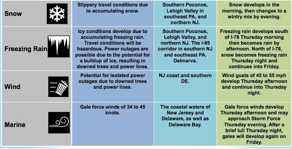
Here are the alerted areas:

Here is what was expected:
- A wintry mix developed over southeast Maryland and Delaware Thursday morning, then lifted into southeast Pennsylvania and southern New Jersey where it became largely snow.
- The wintry weather could last several hours during the day on Thursday before gradually changing to rain during the afternoon (except in Morris, Sussex and Warren counties). Rain may be heavy at times into Thursday evening.
- A wintry mix develops over the Lehigh Valley, southern Poconos, and northern New Jersey by Thursday afternoon and continues into Thursday evening. The wintry mix may last into Friday morning.
- Strong winds gusting to 45 to 55 mph will develop along the NJ shore and southern DE Thursday afternoon and will diminish Thursday night.
- Gale force winds are expected on the coastal waters Thursday through Friday.
Here is how the storm is also impacting traffic:
- I-676: Accident on I-676 northbound south of Exit 4 - Atlantic Ave in Camden. Left shoulder closed 5-10 minute delay; use caution.
- NJ 35: Accident on NJ 35 southbound at Cliffwood Av in Aberdeen Twp. Right lane closed; use caution.
- NJ 55: Accident on NJ 55 southbound south of Exit 48 - Ellis Mill Rd in Elk Twp. Right shoulder closed; use caution.
- New Jersey Turnpike: Accident on the New Jersey Turnpike outer roadway southbound south of Interchange 7 - US 206 in Mansfield Twp. Left lane blocked.
- I-195: Accident on I-195 eastbound west of Exit 8 - CR 539 in Robbinsville. Left lane closed; 10-15 minute delay, use caution.
- New Jersey Turnpike: Vehicle off the roadway on the New Jersey Turnpike northbound south of Interchange 5 - CR 541 in Westampton Twp. All lanes open to traffic.
- NJ 18: Vehicle off the roadway on NJ 18 southbound south of Exit 25 - NJ 79 in Marlboro Twp. Left shoulder closed; 5-10 minute delay, use caution.
- I-295: Accident on I-295 northbound ramp to Exit 14 - Repaupo Road in Logan Twp. Right lane closed; 5-10 minute delay.
- US 206: Disabled tractor trailer on US 206 northbound Hillsborough Rd in Hillsborough Twp. Right lane closed.
- Garden State Parkway: Speed restriction on the Garden State Parkway in both directions from south of Exit 124 - Main St in Sayreville to north of Asbury Toll Plaza in Tinton Falls; 45 mph due to salting operations.
- New Jersey Turnpike: Speed restriction on the New Jersey Turnpike in both directions from Delaware Memorial Bridge in Pennsville Twp to south of Interchange 11 - Garden State Parkway in Woodbridge Twp; 45 miles per hour, due to maintenance salting activities.
- I-295: Disabled truck on I-295 northbound at south of Exit 10 - Center Square Rd in Logan Twp. Right shoulder closed 15-20 minute delay; use caution.
- US 130: Accident and a utility pole down on US 130 southbound at CR 634/Market St in Gloucester City. All lanes closed and detoured 5-10 minute delay; use caution.
- NJ 55: Vehicle off the roadway on NJ 55 northbound north of Exit 29 - CR 552/Sherman Av in Vineland. 1 lane may be closed; use caution.
- NJ 55: Vehicle off the roadway on NJ 55 northbound North of Exit 48 - Ellis Mill Rd in Glassboro. Left shoulder closed; use caution.
- Garden State Parkway: Overturned vehicle on the Garden State Parkway southbound north of Exit 58 - CR 539 in Little Egg Harbor Twp. Right lane blocked.
- NJ 55: Accident and an overturned vehicle on NJ 55 northbound South of Exit 56 - NJ 47 in Deptford Twp. Left shoulder closed 15-20 minute delay; use caution.
- Garden State Parkway: Accident on the Garden State Parkway southbound Great Egg Toll Plaza in Somers Point. Right lane blocked.
- NJ 55: Delays on NJ 55 northbound approaching NJ 42 in Deptford Twp delays due to volume.
Indeed, the storm is a "potent mess" of rain, ice and snow that has even left accumulation as far south as Louisiana, The Weather Channel says.

It would be rather early for accumulating snow in the region. In a typical season, the first snowfall in New Jersey happens around mid-December, according to The Weather Channel.
Snow fell during pre-Halloween nor'easter in 2011; wires and tree branches fell because of the wet snow, and many leaves hadn't fallen yet, adding weight to the power lines and trees.
Motorists and airline passengers in much of the eastern U.S. should be prepared for more delays as the winterlike storm for this week runs its course ahead of the surge in travel around Thanksgiving, according to AccuWeather.
-1542203560-4112.jpg)
The weather pattern will be more typical of late December or early January storm that will persist across much of the eastern U.S. this week. "The pattern not only features much colder-than-average conditions for the middle of November, but is also packed with winter-like storms," AccuWeather said in a news release.
While the bulk of the precipitation is expected to be rain and wintry mix, snow is possible at the onset of the storm, AccuWeather said.
How much snow ends up falling will ultimately depend on the storm track: a low-pressure system close to the coast or inland would draw warmer air from the Atlantic Ocean, leading to more rain than snow, according to The Weather Channel.
-1542203619-542.jpg)
An offshore track would allow cold air to remain locked in across the East, which means snow or an icy mix over a larger swath of the region.
"Since it may precipitate hard at the onset, when temperatures are near or below freezing in the I-95 zone from Washington, D.C. on up, there can be a quick accumulation that makes some roads slippery," AccuWeather Senior Meteorologist Bernie Rayno said.
-1542203641-7740.jpg)
Here is the forecast:
- Friday: A chance of snow or rain before noon, then a slight chance of showers between noon and 1pm. Cloudy, then gradually becoming mostly sunny, with a high near 45. Breezy, with a west wind 15 to 20 mph, with gusts as high as 33 mph. Chance of precipitation is 40%. New precipitation amounts of less than a tenth of an inch possible.
NJDOT photo
Get more local news delivered straight to your inbox. Sign up for free Patch newsletters and alerts.