Weather
Hurricane Jose's Track Shifts, Major Change To RI Forecast
It should still be a rough week, but the impact will be less than originally anticipated.

Hurricane Jose's track has shifted east, meaning much of Rhode Island should less an impact from the passing storm. The southern half of Rhode Island, Southeastern Massachusetts, and the Cape & Islands are still under a tropical storm watch and may get heavy wind and rain, though not as much as originally predicated.
This adjusted forecast comes just a day after many were calling for close to 3 inches of rain and terrible wind gusts of up to 70 miles per hour in some of the harder hit areas. But even with the storm now tracking farther east, much of Rhode Island and the surrounding waters are under some sort of weather advisory or outlook.
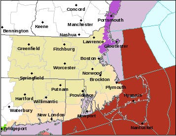
Below is the National Weather Service's 5 p.m. graphic on weather warnings around the state. Red is a rarely seen tropical storm warning, while the purple along the North Shore of Massachusetts is a high surf advisory and the tan that runs across most of Massachusetts, Rhode Island and Connecticut is a hazardous weather outlook. The slightly different tan in the southernmost regions is a hurricane local statement. The tropical storm warning has receded a bit.
Find out what's happening in Portsmouthwith free, real-time updates from Patch.
"It is looking more and more likely that Jose will actually track east enough to confine most impacts to Cape Cod and the Islands," NBC Boston meteorologist Aaron Perry told Patch. "... Right now, expecting tropical storm-force winds moving in across Cape Cod and the Islands later tonight into Wednesday morning as the system begins to transition to an extra-tropical storm."
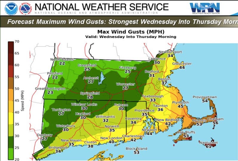
The peak of the wind and rain should be strongest from Wednesday into Thursday. Block Island could still see 50-60 mph wind gusts, while coastal towns may experience up to 45 mph winds. You can see all the expected maximum wind gusts below:
Find out what's happening in Portsmouthwith free, real-time updates from Patch.
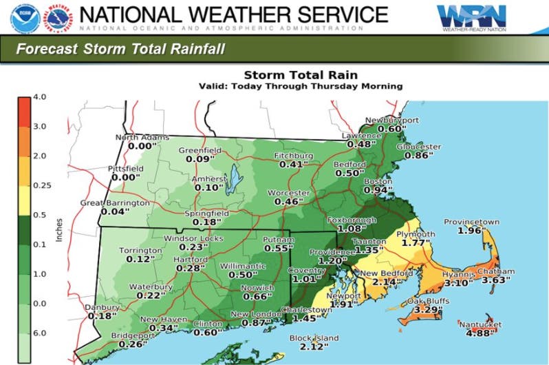
The adjusted forecast is also still calling for tons of rain in the Cape & Islands, but not as much as originally anticipated in Rhode Island. Southeastern Massachusetts could see more than 2 inches, but most of Rhode Island should stay between 1-2 inches.
Only three tropical storms have made landfall in New England this century: Tropical Storm Hermine in 2004, Tropical Storm Beryl in 2006 and Hurricane Hanna in 2008. Hanna was a tropical storm by the time it touched down. The last time a hurricane reached New England land was 1991; Hurricane Bob was a Category 2 storm.
Also See: Hurricane Maria Makes First Landfall As A Category 5 Storm
Get more local news delivered straight to your inbox. Sign up for free Patch newsletters and alerts.