Wednesday was the deadline to submit maps to the five-member Districting and Apportionment Commission, which met Friday. And while commissioners didn’t comment during the meeting about the substance of the maps, they heard comments from individuals and organizations advocating for their preferences and received nearly 200pages of public comment sent in before the meeting.
What district Flathead and Gallatin counties belong in drew sharp responses, as did the idea of dividing two of the most populated counties in the state. Flathead is a GOP stronghold, while Gallatin is increasingly voting for Democrats.
Questions also arose about how to keep together or divide the state’s reservations and tribal communities.
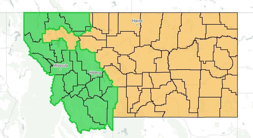
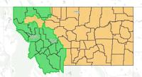
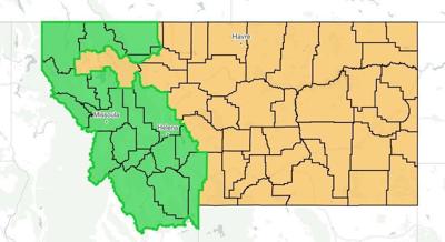
Another dividing line is how to separate the state — either on a east-west line like the one Montana had decades ago when it last had two seats in the U.S. House or a north-south line, which one commenter dubbed the “Hi-Line, Low-Line” option. Commissioners noted many maps are likely the same or similar and could be grouped together to review.
Comments also raised concern about whether districts should be crafted to be competitive. The commission’s mandatory criteria states districts have to be as equal in population as possible, protect minority voting rights and have compact and continuous borders.
Goals for the districts include not being drawn to unduly favor a political party; minimizing dividing cities, towns, counties and federal reservations between two districts when possible; and keeping communities of similar interest intact. The commission may also consider competitiveness of districts when drawing plans.
The commission meets Oct. 5 to select which maps to receive public comments and there’s a public hearing set for Oct. 19. On Oct. 21 the commission meets again to select a tentative final map and there’s a public hearing Oct. 30 on that map, along with a commission vote. The commission must file its plan with the Secretary of State by Nov. 14.
The 2020 Census found Montana gained enough population to add a second seat, which it had until 1991. Many comments, both written and delivered during Friday’s meeting, advocated for the same east-west line as the state had before.
Census data showed that with the exception of Yellowstone County, the already more-populous counties on the western side of the state like Flathead, Lewis and Clark, Missoula and Gallatin, all added more people than more rural counties in Eastern Montana from 2010 to 2020.
“This puts it pretty starkly,” said commissioner Kendra Miller. “There is no going back to the 1980s district. … The new congressional configurations for Montana will look a lot different. … I think this is really important for the public to really understand that the old line will not work anymore, and we would not be in compliance with the law if we were trying to go back to the 1980s districts.”
Ta’jin Perez, the deputy director of Western Native Voice, advocated for a map that kept the Blackfeet Tribe and the Confederated Salish and Kootenai Tribes together in a competitive district in the west and the state’s six other tribes in an eastern district he said would favor Republicans. Perez said a competitive district would result in more engagement from elected officials.
“Politicians rarely visit Native American reservations,” Perez said. “ ... We believe that due to political disenfranchisement, Native communities have been ignored for too long. Having competitive congressional districts will serve to make politicians more responsive and more responsible.”
The Blackfeet and CSKT have economic and cultural ties, Perez said, and have shared a legislative district for years.
The district he backs would divide Flathead County generally along U.S. Highway 2.
“No map is perfect but we assert that the proposed map does the best job of adopting all the rules the commission must follow,” Perez said.
Public comment submitted from the Flathead County Board of Commissioners, however, urged the commission to not split their county.
”Preserving the county as an entire district will enable a representative to serve a homogeneous district and provide strength in numbers to address the ongoing growth challenges to the county,” the letter read. “Our vote and representation as we manage this surge of people should not be diluted.”
State Rep. Derek Skees, a Republican who represents a district that includes part of Flathead County and is running for the Public Service Commission, said during Friday’s meeting he was “totally against” a map that would divide Flathead County. Skees argued proposals to do so falsely assume a commonality with other communities like Big Sky and ignore how the cities and towns within the Flathead are tied together.
“We’re surrounded by mountains. We’re surrounded by a geography that drives us all together, north and south of that Highway 2. So this map, I think, goes against many of the criteria,” Skees said, adding he didn’t disagree with keeping the Blackfeet and CSKT in one district.
“Splitting Flathead County, the largest Republican county, directly in half along mostly partisan lines like the way this map is drawn is a failure,” Skees said.
State Sen. Mike Lang, a Republican from Malta, also submitted a comment advocating for minimizing the splitting of cities and counties, using the same duplicate language as dozens of other submissions that said districts should be compact and contiguous. But he ended his letter saying he favored an east-west map that divided Gallatin County.
That form letter also urged that commissioners “Do not create ‘competitive’ districts — based on politics! The Congressional district lines should be drawn based upon Montana law, NOT gerrymandered based on political data.”
Nancy Leifer, president of the League of Women Voters of Montana, called for the commission to draw “two congressional districts that are fair to all Montanans.”
“Fairness includes taking into account the likely political impact of proposed districts in representing the voters of Montana,” Leifer wrote. “This is not gerrymandering; this is ensuring that the goal of not unduly favoring one party is not left to chance.”
Lake County’s commissioners submitted a letter advocating for a district drawn along a north-south line. The letter said one commissioner had lived on both sides and commented that crossing the Continental Divide was “like entering a different country.”
”A north/south line is a logical, common-sense and fair solution,” the commissioners wrote.
Send us your thoughts and feedback as a letter to the editor. Submit by email, by post to 2820 W. College St., Bozeman, MT 59718 or use our online form.
Support quality local journalism. Become a subscriber.
Subscribers get full, survey-free access to the Bozeman Daily Chronicle's award-winning coverage both on our website and in our e-edition, a digital replica of the print edition.