The National Weather Service warns of rapidly developing East Coast storm
A storm will intensify off the East Coast but how close it will come to the coast is still in question.
By Judson Jones and Haley Brink, CNN
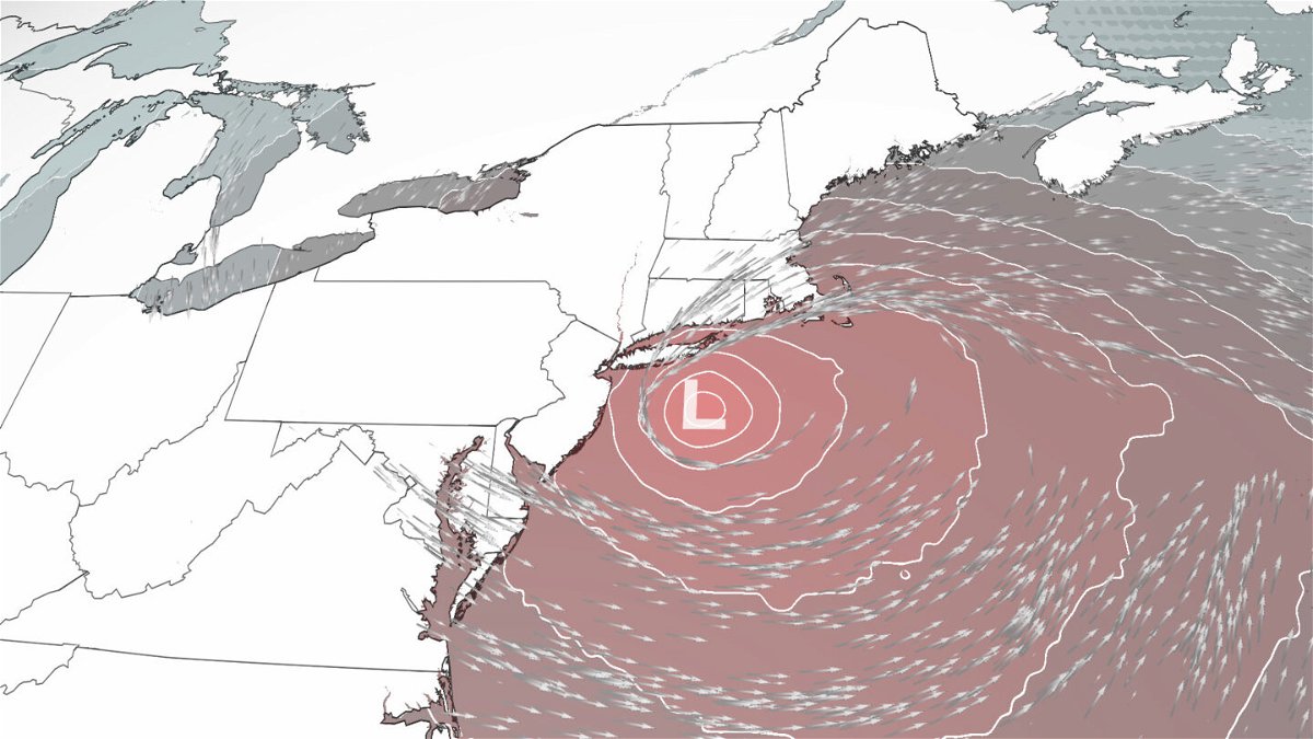
As a historic “bomb cyclone” winds down on the West Coast, computer forecast models are hinting at a possible autumn nor’easter on the East Coast starting Tuesday.
It just won’t have all the snow that you usually expect from this kind of storm. Instead, this intensifying storm will bring extreme winds and heavy rains — the last thing New Yorkers really want to see after the devastating flash flooding this year.
“A rapidly developing low pressure system south of Long Island will likely produce heavy rainfall across the region,” the National Weather Service in New York says.
Flood and flash flood watches are in effect from southern New Jersey to northern Massachusetts.
There is no doubt that the rainfall in the Northeast over the next couple of days will be because of this strengthening low pressure system. But there remains uncertainty on how strong it will get and how close to the coast it will track.
“Anytime you have two areas of low pressure trying to combine in the warm Gulf Stream off the Northeast Coast, models will differ on their solutions,” says CNN meteorologist Chad Myers.
Forecasters are certain there will be rain but still unsure of how much. The Weather Prediction Center has issued a level 1 out of 4 “marginal’ risk” for excessive rainfall Monday and a level 2 “slight’ risk” for excessive rain Tuesday.
“Rainfall totals as this time look to be on the order of 2 to 4 inches,” the weather service in New York wrote.
But some computer weather models are showing isolated amounts of 5 to 7 inches of rainfall.
“Hopefully, this scenario does not come to fruition as this would lead to widespread flooding issues,” writes the New York weather office.
Winds are the other issue; the closer this storm tracks to the Northeast coast, the more robust the winds will feel to people living along the coastline. A closer storm also means that stronger winds will spread further inland.
Winds gusting to over 50 mph are not out of the question for eastern Massachusetts, Rhode Island and Connecticut, with gusts topping out near hurricane-force on Cape Cod and the Islands.
With the winds will also come coastal flooding, which is possible during high tide cycles on both Tuesday and Wednesday, the weather service said.
A similar system, made famous by George Clooney in the ’90s, has its 30th anniversary later this week. While forecasters don’t think this will be “The Perfect Storm,” it will share some similarities in the types of conditions that can be expected.
The Boston National Weather Service has an interesting write-up on the storm’s anniversary.
Another similar storm to Tuesday’s nor’easter will try to develop by the weekend, says Myers. “But the energy for that one is still off the West Coast and will need some more time to forecast accurately.”
A ‘bomb cyclone and an ‘atmospheric river’
Speaking of the West Coast “bomb cyclone,” this storm strengthened to become the strongest storm — measured by pressure — ever off the coast of Washington.
The center of the storm passed right over an ocean buoy, which recorded the record pressure drop.
A bomb cyclone is a system that drops at least 24 mb in pressure 24 hours or less — and typically, the lower the pressure, the stronger the storm.
But, like was mentioned in last week’s pop-up weather newsletter, it was the related “atmospheric river” that has caused the greatest impact to the West Coast.
An atmospheric river is a narrow band of concentrated moisture that cruises more than 2 miles above the ocean and releases rain or snow when it hits land — and this one was a level 5 of 5.
It has delivered in 24 hours more rain than Sacramento, California, has ever recorded in one day. And it is still raining. In San Francisco, they experienced their fourth-rainiest day in history.
But it is the debris flows and mudslides that have been the most significant impact in this drought-plagued region.
You can read more about the ongoing impacts of the atmospheric river and when it will wind down here.
Enhanced severe threat midweek
As the storm in the West continues to track east on Tuesday, it will bring with it the threat for severe storms across the central states.
A level 3 out of 5 “enhanced” risk for severe storms has been issued across the central and southern Plains for Tuesday. Overall, the severe storm threat encompasses over 20 million people including Wichita, Kansas; Oklahoma City; and Fort Worth, Texas.
“Scattered severe thunderstorms associated with large hail, wind damage and an isolated tornado threat are expected across parts of the southern and central Plains from late Tuesday afternoon through the evening into the overnight,” the Storm Prediction Center said Monday morning.
This storm system comes right on the heels of another system that brought damaging tornadoes to areas of Missouri and Illinois over the weekend.
On Wednesday, this severe storm threat will shift south into the Gulf Coast, where a level 2 out of 5 “slight” risk of severe storms has been highlighted. This risk area includes Houston, New Orleans and Mobile, Alabama, where damaging winds and a few tornadoes are possible through the afternoon and evening hours.
Forecasters predict a warmer winter
The 2021 winter outlook was released this past Thursday by the National Oceanic and Atmospheric Administration.
A warmer and drier-than-normal winter is forecast for the nation’s southern region, along with a wetter-than-normal winter for the Pacific Northwest and northern Rockies, the agency said.
In all, cooler and wetter conditions are forecast across portions of the northern tier of the country, with warmer and drier conditions for much of the southern tier — in line with a typical La Niña weather pattern.
However, the Southwest may suffer the most from this winter’s forecast, as little drought relief is in sight.
Read more about the winter forecast here.
Iconic palm trees slowly disappear in Florida
When you think of Florida, images of beaches and palm trees come to mind. But what if those palm trees were slowly replaced with other trees?
That’s what could happen over time thanks to climate change. Groups in Florida are choosing to plant oaks over palms.
Florida’s beloved palms are much less effective at carbon sequestration compared to other types of trees.
Read more about how communities in South Florida are trying to save the world from the climate crisis, one tree at a time.
Halloween weather won’t make you say boo
Like many of you on a Monday, we are already looking forward to the weekend. And that is because Halloween weather is looking pretty good for most this weekend.
Apart from the aforementioned second storm departing the Northeast — bringing rain from the Appalachians northward on Saturday and lingering in New England Sunday — and a few scattered showers across the mountain West, the rest of the country is looking dry for the weekend.
Temperatures will be above normal through the central US on Saturday but quickly cool off in the northern and central Plains Sunday — 15 to 20 degrees colder than the day prior.
The Southeast will be on the cool side with highs in the upper 50s and 60s, with similar temperatures expected in the Northeast — warmer than normal. The West Coast will see near-normal temperatures in the 60s for most.
The-CNN-Wire
™ & © 2021 Cable News Network, Inc., a WarnerMedia Company. All rights reserved.
CNN meteorologist Monica Garrett contributed to this report.