


Across the Corn Belt, cold, mostly dry weather prevails. However, corn and soybean harvest activities remain limited in many areas by wet fields or—in the upper Midwest—a substantial snow cover.
On the Plains, early-season snow is blanketing Texas’ northern panhandle and environs, while an ice storm is glazing portions of western Oklahoma. The winter storm, while highly beneficial for winter wheat, is causing travel disruptions and increasing livestock stress. Farther north, temperatures have begun to rebound from historically low levels—but remain below normal. On Tuesday, lows of 0° in Goodland, Kansas, and Burlington, Colorado, set October records for those locations. However, an extensive snow cover is helping to insulate the Plains’ emerging winter wheat crop.
In the South, rain showers are spreading northward in advance of Hurricane Zeta, halting pre-storm efforts to harvest crops such as cotton, soybeans, and sugarcane. At 7 am CDT Wednesday morning, Zeta was centered 295 miles south-southwest of New Orleans, Louisiana, moving toward the north at 17 mph. Sustained winds are near 90 mph. Meanwhile, sharply colder air is overspreading the western fringe of the region, from Texas into Arkansas.
In the West, the wildfire threat in southern California is slowly diminishing as winds subside, but several fires remain active. Southern California’s Silverado and Blue Ridge Fires—both of which started on October 26—have collectively burned nearly 28,000 acres of vegetation. Elsewhere, beneficial snow is gradually ending in the drought-affected southern Rockies, while warmth is returning across northern California and the Pacific Northwest.
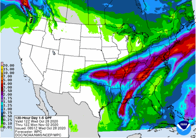
During the next 2 days, the rare interaction between a winter-like storm and a hurricane (Zeta) will generate at least 2 to 4 inches of rain across a broad area from the mid-South and the lower Mississippi Valley into the central and southern Appalachians and the mid-Atlantic. Zeta will make landfall later today in southeastern Louisiana, delivering a significant storm surge (as much as 6 to 9 feet), damaging winds, and heavy rain. Tropical storm-force winds (39 to 73 mph) could spread will inland from the central Gulf Coast into the southern Appalachians. Zeta could adversely affect some unharvested summer crops, including sugarcane and open-boll cotton. Elsewhere, wintry weather on the southern Plains will end by Thursday, while little or no precipitation will fall during the next 5 days across the West, the northern half of the Plains, and the upper Midwest. Temperatures will continue to slowly moderate, with warmer-than-normal weather gradually returning across much of the West.
Looking ahead, the 6- to 10-day outlook calls for the likelihood of below-normal temperatures across much of the southern and eastern U.S., while warmer-than-normal weather will prevail in southern Florida and along and west of a line from the southern Rockies to Lake Superior. Meanwhile, near- or below-normal precipitation across most of the country should contrast with wetter-than-normal weather in western Washington and southern Florida.