

The Ultimate Great Smoky Mountains Travel Guide
Despite being one of the most popular destinations in the U.S., the Smokies make it easy to plan a last-minute trip and avoid crowds year-round. Here’s our definitive guide on what to know before you go, how to make the most of all the park has to offer, and can’t-miss experiences in every season.
Heading out the door? Read this article on the Outside app available now on iOS devices for members! Download the app.
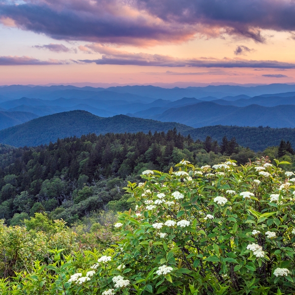
Even if you haven’t been to our most visited national park yet, you can probably picture those blue ridgelines blurred across a southern Appalachian sky by that perpetual, namesake haze. In the spring, the sight is often the backdrop for a field of colorful wildflowers; in the fall, a rich palette of changing leaves. I’m lucky to call the 500,000-acre Great Smoky Mountains National Park my backyard, and they call images to mind that captures their character. There’s the black bear sprawling over a low branch, paw dangling; the silhouette of an elk bugling against the fog in a valley; and countless 19th-century log cabins, barns, and springhouses that sit at the edges of wildflower-filled meadows just off of roads and trails, like pioneer exhibits in a museum.
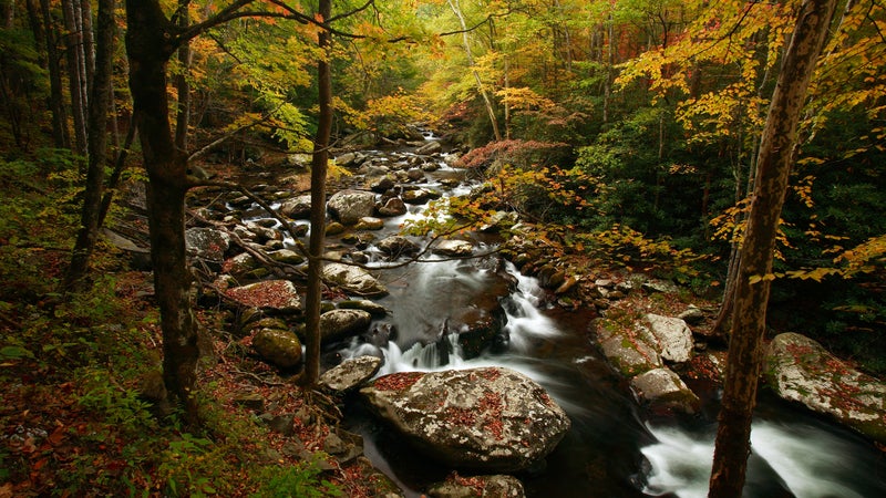
While you’ll count yourself among 11 million people on average who visit the range every year, you can still find something personal and deeply profound in its lush valleys, ridgeline paths, and panoramic lookouts. For some this happens while exploring the more than 90 historic sites the park service maintains, while others are captivated by the slanted headstones, crumbling chimneys, and buckling walls in the backcountry. Many find solitude in the 850 miles of trails, ranging from scenic day hikes to multi-day treks along 70 miles of the Appalachian Trail—do them all and you can join the 900 Miler Club. Just off the paths, and often running parallel, are streams home to one of the last wild-trout habitats in the region, including the distinct southern Appalachian brook trout. But for most, what makes the Great Smoky Mountains special is how each season has its own distinct character and reasons to visit, from spring’s colorful blooms to winter’s unobstructed peak views.
What You Need to Know Before Visiting Great Smoky Mountains National Park
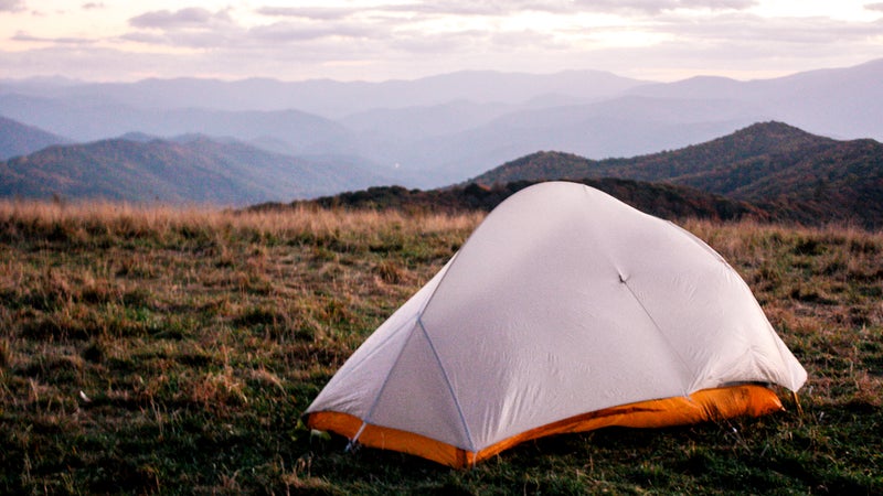
You can make it a spontaneous trip. Unlike most national parks, there’s no entrance fee or lottery reservations system for the Smokies, which makes it an affordable way to get into the woods with a short lead time. Backcountry sites can be booked as early as a month before your trip—a necessity for holiday weekends—or as late as the morning you head out, while major public campgrounds can be booked from six months to a year in advance.
Expect rain and rapid shifts in conditions, no matter what time of year you visit. The rain that keeps the park green year-round—on average 55 inches of it falls in the valleys and 80 inches on the mountaintops—is what you’d expect from any other temperate rainforest and can be a minor inconvenience when it clouds your view, interferes with your photo ops, or shuts down roads. Abrupt summer storms often lead to flash floods that have caused landslides and closures, while ice is the perpetual culprit during winter months (even though its mountains rarely reach up to 6,000 feet, winters are generally marked more by ice than snow in all but the highest elevations). Always use Smokies Road Info on Twitter to check conditions before you go. Depending on your elevation, temperatures can also vary sharply, as much as 30 degrees, which often means the highs feel hotter and the lows much colder. Treat weather and temperature forecasts as gentle suggestions, and prepare for something harsher.
Don’t let the crowds deter you from some of the park’s greatest spectacles. The months of June and October could be considered two seasons in and of themselves. The last three weeks of October are some of the busiest times, when hordes of people chase the color of the leaves from the top of the mountains down into the valleys. In June, day hikers make the 11-mile round-trip to the summit of Gregory Bald to see flame azaleas, flowering shrubs that range from deep orange-reds to candy pinks and yellows, often on the same blossom. Nighttime visitors set up camping chairs on the Little River Trail near Elkmont Campground to watch the fireflies. By 10 P.M., the insects rise up from damp creek valleys and, in unison, flash seven or eight times, and then, just as uniformly, go dark. The display is so popular that Elkmont’s campsites fill up fast. But you don’t have to camp to see them: the park runs a shuttle from Sugarlands Visitor Center. (Note that parking at the campsite is limited, and the lottery for a space only opens for a few days in late spring.)
How to Get There
The Smokies straddle North Carolina and Tennessee. Asheville, North Carolina and Knoxville, Tennessee, the largest nearby cities, are roughly an hour from the park. The closest major airport is McGhee Tyson near Knoxville; it’s a little over a half-hour from the park’s Townsend, Tennessee, entrance and provides easy access to the Cades Cove valley on the western side of the park. The towns of Cherokee, North Carolina, and Gatlinburg, Tennessee, abut the park boundaries to its north and south, respectively, and are the main gateways via U.S. Route 441. Across the mountains to the east, on the North Carolina side of the park, Bryson City opens some of the less visited areas around Fontana Lake, like the Road to Nowhere and Noland Creek Trails.
When Is the Best Time of Year to Visit the Smokies?
The park and its backcountry sites are open year-round. The off-season, which runs from late October through May, closes seven of the park’s ten developed campgrounds; Cades Cove on the Tennessee side and Smokemont in North Carolina stay open. Rest areas and picnic areas close, too, as well as most secondary roads. The main thoroughfare, Route 441, which runs from the Cherokee Reservation in North Carolina to Gatlinburg, only closes for bad weather. Summer is the wettest season—July has the most rainfall—while fall, after the tail end of a typically humid August, is the driest. Every season has its draws and limitations.
Winter: Winter is the season of long views and a solitude that’s hard to find the rest of the year. Take advantage of the highest viewpoints, like the pullouts at Newfound Gap and the observation deck at the end of the Clingmans Dome Trail or the towering upper ridges from lower-elevation trails. The Roundtop Trail, a lightly trekked, 7.5-mile point-to-point route that begins near Metcalf Bottoms off Little River Road and dead-ends on the banks of the Little River, will lead you no higher than 2,600 feet and offers views of Cove Mountain and Chinquapin Knob within the first mile. Even during the busier seasons, you’re likely to be the only person on the Roundtop Trail, but in the winter, the views from this trail will make you feel like you’re the only one in the park. While winter hiking won’t lead you into more than a dusting of snow, you’ll probably find ice in the frozen springheads on most trails. Bring crampons, especially if you plan to hike higher.
Spring: While winter’s sparse vegetation will have you looking out from mountaintops—or up at them—you’ll likely be looking down during spring. The popularity of the blooms that take place from March to June draw the first wave of crowds, with most flowers blossoming from the middle of April to the middle of May. The challenge to catching them at their height isn’t navigating the traffic or even finding the correct trail but rather figuring out where to go to see the particular flowers you’re looking for, from the white-fringed phacelia and maroon trillium to the pink and yellow lady’s slipper. Every April for the past 68 years, the park has celebrated the Spring Wildflower Pilgrimage (from $150), a weekend of guided walks and exhibits. If you prefer a self-guided tour, the event’s website suggests five trail options; two of the most popular are the Middle Prong, in the Tremont area, and Schoolhouse Gap, a 20-minute drive west. If you’re looking for that perfect photograph, head 3.5 miles up Porters Creek Trail in the Greenbrier area, where flowers blanket the ground like snow, or up the 8.6-mile Chestnut Tops Trail from the Townsend Wye swimming hole to see upward of 30 different species of wildflowers in the first half-mile.
Summer: With this season’s swelling crowds, trailheads fill up by midmorning, so plan to get there early. For popular hikes, like Chimney Tops, Laurel Falls, and Alum Cave Trail, set out shortly after sunrise. Given the number of trails and their close proximity to larger towns, the Tennessee side of the park fills up faster than the North Carolina side, so escaping the masses often means heading to North Carolina’s Fontana Lake. The Lakeshore Trail, a 35-mile one-way along its western banks, intersects less traveled paths that link to the surrounding mountains. To the east, 2.9 miles from the Road to Nowhere Trailhead, is the 11.4-mile Forney Creek Trail, which leads up to Andrews Bald, a destination popular for its views of the surrounding highlands. Seven miles from the western side of Fontana, the Lakeshore Trail joins the 8.9-mile Eagle Creek Trail. With 18 wet crossings, the trail is an ideal summer hike up the mountain to the highland meadow of Spence Field, which is less than two miles west of Tennessee’s iconic Rocky Top (known for its 360-degree panoramic views) via the Appalachian Trail.
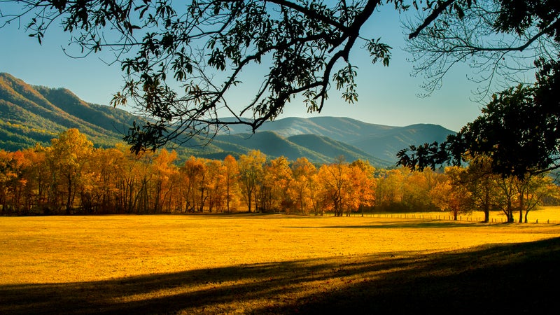
Fall: When cooler temperatures hit, you’ll find more elk and bears in the valleys (and usually don’t have to leave the car to see them). Head to the remote Cataloochee Valley for likely sightings of elk and out to Cades Cove for the bears, though be aware that a trip to Cades Cove can be an hours-long, bumper-to-bumper, 11-mile drive. On foot you can expect to see black bears and elks anywhere in the park. Remember to keep 50 yards between yourself and the wildlife when you go looking for them. The park is also known for its foliage, so opt for a trail that cuts through old-growth, hardwood forest, like the Albright Grove Loop off the eight-mile Maddron Bald Trail and the six-mile Low Gap Trail up to Mount Cammerer and back.
Where to Stay in Great Smoky Mountains National Park
Developed Campgrounds
Located along the Gatlinburg and Oconaluftee River Trails, the park’s ten designated campgrounds range in price from $17.50 to $27 a night and offer no-frills amenities, restrooms, and water. Book reservations on Recreation.gov as early as six months to a year in advance. The Smokemont, Elkmont, and Cades Cove campgrounds are busiest due to their central locations and electrical hookups. Consider instead the Balsam Mountain Campground ($17.50 a night), just off the Blue Ridge Parkway near the Cherokee Reservation’s eastern Qualla Boundary, for seclusion, mountain views, nearby streams, and the chance to see elk grazing just beyond your tent. At an elevation of 5,310 feet, Balsam Mountain is the highest developed campground in the park, which means temperatures rarely get above 70 degrees, even in the southern summer heat, but it’s also especially subject to the area’s characteristically fluctuating weather. There are several uncrowded trails that lead from the campsite, including a 5.2-mile out-and-back nature hike on Flat Creek Trail through hardwood forest and a more challenging 14-mile loop that drops into Cataloochee Valley from the Hemphill Bald Trail before climbing back up Rough Fork Trail. Be sure to make the short walk from your campsite to the Heintooga picnic area to watch the sun set over the Smokies’ ridgelines.
Backcountry Campgrounds
The park’s more than 100 backcountry sites include five boat-in areas—three on islands in Fontana Lake—and more than 15 shelters at higher elevation along the 70 miles of the Appalachian Trail. Almost all include fire grates and bear cables. A nightly rate of $4 a person gets you a backcountry campsite or shelter with direct access to springs or running water. Reservations can be made at the park’s own backcountry-reservation website. Appalachian Trail thru-hikers can purchase a $20 pass for all of the shelters but must give up space to any campers with a backcountry permit. Generally, you won’t have any trouble finding an open campsite during most seasons, but availability ebbs and flows in the busy months of June and October. Make sure to check the park’s website for warnings and closures before you go—the weather can cause you to reschedule your trip as unexpectedly as bear activity in the area.
The wildly varying character of each backcountry campsite reveals different aspects of the Smokies’ long history and allows for every kind of camping experience. Lower Ekaneetlee/campsite 89, at the mouth of Ekaneetlee Creek along Eagle Creek Trail, marks the beginning of a Cherokee track that settlers followed across the ridgeline to settle the Cades Cove valley (the old railroad tracks from a later logging camp are still there). Some options, like West Prong/campsite 18, in northwestern Tremont on the Tennessee side, and Big Hemlock/campsite 40, in Cataloochee Valley to the northeast, are relatively short, gradual hikes from the main trailheads of West Prong Trail and Rough Fork Trail, respectively, which make them perfect for a quick overnighter or a child’s first backcountry experience. West Prong has plenty of trees for shade and hammocks; Big Hemlock is partitioned by huge logs so that an outing feels private even when the site is full. Expect campsites like Proctor/campsite 86, at the mouth of Hazel Creek, located in the area along Fontana Lake’s north shore, or Rough Creek/campsite 24, at the head of Little River’s East Prong along Rough Creek Trail, to fill up faster due to their prime fishing locales.
LeConte Lodge
In operation since 1926, the 60-guest LeConte Lodge sits atop the Smokies’ third-tallest peak and marks the site where conservationists wooed officials from Washington, D.C., into supporting the park’s creation. Due to its high demand, you’ll have to make online reservations a year prior. A stay includes a bed or a bunk in a rustic cabin and meals in the main lodge (from $162, including breakfast and dinner). Accessible by five trails, the lodge has kept its stuck-in-time feel with basic amenities to match (wash basins, kerosene lanterns). For a longer route that includes a path that cuts below Grotto Falls, follow the 8.9 miles of the Trillium Gap Trail from the Roaring Fork Motor Nature Trail to the lodge. Otherwise, the shortest and steepest way up the mountain is via the 5.5-mile Alum Cave Trail.
Things to Do in Great Smoky Mountains National Park
Driving
You don’t have to leave your car to enjoy the Smokies. The 11-mile Cades Cove scenic drive and six-mile Roaring Fork Motor Nature Trail are worth doing to experience the park’s varied landscapes, even if you plan to spend most of your visit on foot. In 2018, the park opened a new 16-mile-long section of the Foothills Parkway in Tennessee from the town of Walland to Wears Valley, near Pigeon Forge, with area views from the crest of Chilhowee Mountain.
Cycling
With no mountain-biking trails and steep, narrow roads that host a lot of car traffic, there’s little opportunity to cycle in the park, except for Cades Cove, which from early May to late September is closed to vehicles on Wednesday and Saturday mornings until 10 A.M. The one-way loop allows for plenty of wildlife viewing and stops at 19th-century homes.
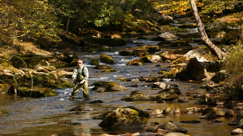
Fishing
There are close to 2,900 miles of streams in the Smokies, of which 20 percent are large enough to support trout. Fishing is permitted year-round in open waters, and in the fall, you can stalk brown trout in the deep runs along Little River Road or charter a boat shuttle ($30 one way) from the Fontana Village Resort & Marina across Fontana Lake to catch rainbow trout on Hazel Creek. The headwaters above the creek are full of brook trout and remain local anglers’ favorite spots. Try Lynn Camp Prong Cascades, the park’s most recent brook-trout restoration project, which parallels Middle Prong Trail, an easy eight-mile hike that features multiple waterfalls. You’ll catch the most fish on the Tennessee side of the park above the Panther Creek Trail juncture, a small tributary off Lynn Camp Prong, about 2.5 miles in on the trail. Pack a fly rod and some peacock-bodied flies.
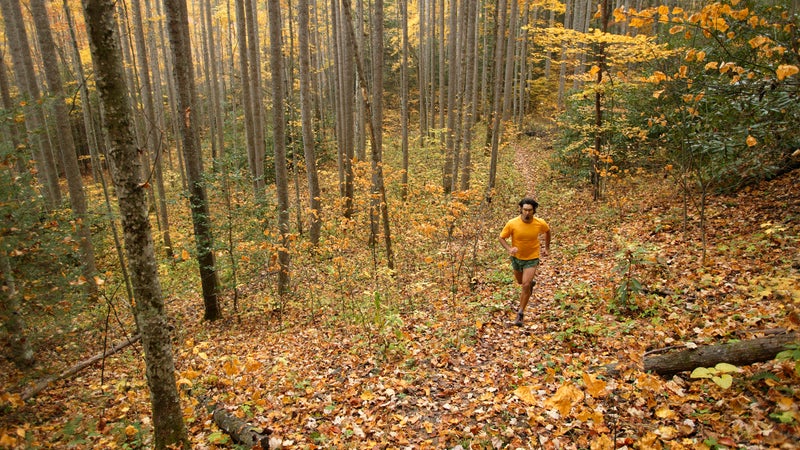
Hiking
More than 850 miles of trails lead into the park, ranging in length from largely overlooked, quiet, quarter-mile walkways—short dirt paths just off the main roads—to 70 miles of the Appalachian Trail. One of the most popular day hikes is an eight-mile round-trip that follows the AT north from Newfound Gap to Charlies Bunion and offers some of the park’s longest-range views. You’ll find more solitude and similar views on another section of the AT, a 11-mile out-and-back above Cosby Campground to the Mount Cammerer Lookout Tower, a go-to spot for sunrise photos.
One of the best, most solitary views in the park is from the High Rocks, where an old warder’s cabin sits beside a gray bluff that once supported a fire tower. From there you can see the jagged ridges of Nantahala National Forest across Fontana Lake. To get there, take the ridgetop Welch Ridge Trail, which runs between the AT and the Cold Spring Gap Trail. It’s a rigorous ten-mile hike one-way, so plan to overnight it at one of backcountry sites in the Forney Creek valley or at the Silers Bald shelter.
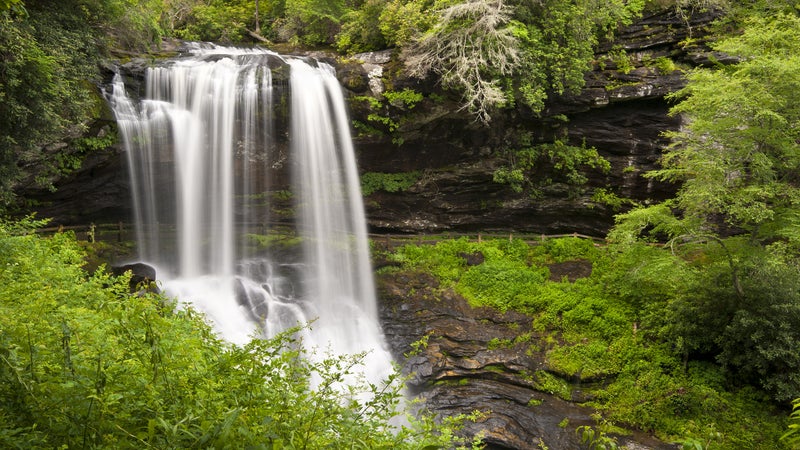
Those who want to see multiple waterfalls, springtime wildflower displays, and panoramic fire-tower views should head to the Big Creek Trail for a two-night trip. Start the first day with a five-mile hike from Big Creek Campground to Lower Walnut Bottoms/campsite 37, which has dense displays of spring flowers. On the way, you’ll pass the Midnight Hole, a favorite swimming spot in the Smokies, and Mouse Creek Falls. On the second day, head up four miles along Swallow Fork Trail, an old Civilian Conservation Corps trail long popular with hikers, to the Mount Sterling Ridge Trail, and stay the night at Mount Sterling/campsite 38, a breezy, cool area at the base of a fire tower. The next morning, head back to Big Creek Campground on Baxter Creek Trail, a sharp descent of 4,000 feet over six miles.
History
If history is your way into the Smokies, you can find stories of southern Appalachia’s pioneer past throughout the park. In the Cades Cove valley, there’s a working gristmill, numerous barns and houses, and three churches from the early 1800s; in Cataloochee, you’ll find the well-preserved homesteads of the Caldwell and Palmer families, which date from the late 19th century; and on the Roaring Fork Motor Nature Trail, in the Gatlinburg area, popular sites include the cabin of Noah “Bud” Ogle, whose great-grandparents were some of the first Euro-American settlers, and a few structures farther along the trail that tell stories of mountain people who refused to be displaced by the formation of the park, like the Walker Sisters cabin, just off Little Brier Gap Trail, which the park has maintained since the last of the five sisters lived there in 1964. In the backcountry, you’ll find the remains of old homes on the Old Settler’s Trail, as well as hearths and chimneys that mark the Depression-era Civilian Conservation Corp camps, like CCC/campsite 71, as well as the artifacts left by the logging operations that ravaged the range in the early 20th century.
Rafting and Kayaking
Along the northern border of the park flows Pigeon River, where a number of outfitters lead whitewater rafting trips. The Upper Pigeon features Class III and IV rapids across 6.5 miles, while the river’s lower section, Pigeon Gorge, is ideal for families looking for gentle rapids and swimming holes. The Gatlinburg-based Rafting in the Smokies runs spring and fall trips from $46 per person. For flat-water kayaking and canoeing, the sprawling Fontana Lake has many fingers to explore.
The Best Places to Eat and Drink Around the Smokies

Your food options in the park are limited to what you pack in or buy from concessions at its major campgrounds, so get your fixes before and after. If you start your day in Asheville, go to Biscuit Heads, downtown, and dredge a cathead biscuit in its espresso red-eye gravy. And if it isn’t too early in the day, make sure to catch a brew tour of Asheville, which has a burgeoning craft-brewing scene.
If you’re traveling through Knoxville, head to Stock and Barrel, on the corner of Market Square, and order the bison burger with a side of duck-confit fries. Follow that with ice cream from Cruze Farm on Gay Street.
Closer to the park, a meal in Gatlinburg often involves standard southern comfort fare—stop by Delauders BBQ for family-style smoked meats or Cherokee Grill for seafood platters. The moonshine once distilled in the far-back hollows of town is on the main street now: Ole Smoky Moonshine usually has 20 types to sample.
A tradition for at least 50 years, park visitors leaving through Townsend, Tennessee, have capped off their trip with a stop at Burger Master. The parking lot is always full, even though it’s just simple, backyard-style comfort foods, banana splits, and chocolate-dipped ice cream. But go less for the food than for a drive-in atmosphere and post-camp crowd.
If You Have Time for a Detour
The park’s nearby towns cater to tourists. Much of the traffic in Cherokee, North Carolina, outside the Oconaluftee entrance on the park’s south side, located on the Cherokee Indian Reservation, stops by the Museum of the Cherokee Indian and the various shops selling crafts. Just west, in Bryson City, is the Great Smoky Mountains Railroad, where you can take a train ride into Nantahala Gorge. In summer, in the Tennessee town of Pigeon Forge, near the Sugarlands entrance, you can visit the Dollywood theme park, and in winter, ski above Maggie Valley at Cataloochee Ski Area or take a tram up to Ober Gatlinburg.
Editor’s Note: We frequently update this National Parks guide, which was originally published on Oct 8, 2019.