NWS Billings issues Winter Storm Warning through Thursday
- Updated
The National Weather Service in Billings has issued a Winter Storm Warning for portions of central and south-central Montana.
A Winter Storm Warning remains in effect from midnight Tuesday through noon Thursday.
What is expected: Heavy snow. Total snow accumulations of 6 to 10 inches, with localized heavier amounts. Winds could gust as high as 40 mph, creating blowing and drifting snow.
Where: This warning includes the locations of Roundup, Melstone, Musselshell, Hysham, Bighorn, Colstrip, Forsyth, Ingomar, Angela, Billings, Laurel, Huntley, Pompeys Pillar, Custer, Broadview, Bridger, Joliet, Fromberg, Belfry, Warren, Hardin, Crow Agency, and Busby.
When: From Tuesday night through Thursday morning. Rain will transition quickly to snow late tonight, with snow becoming heavy at times overnight into Wednesday morning.
Impacts: Travel and outdoor activities will be very difficult. Rural travel may be impossible in some locations. Tree and power line damage is likely and may result in power outages. Those with hunting or recreation interests should prepare accordingly.
Precautionary/preparedness actions: If you must travel, keep an extra flashlight, food, and water in your vehicle in case of an emergency.
For the latest road conditions, call 511 or go to https://roadreport.mdt.mt.gov/travinfomobile/.
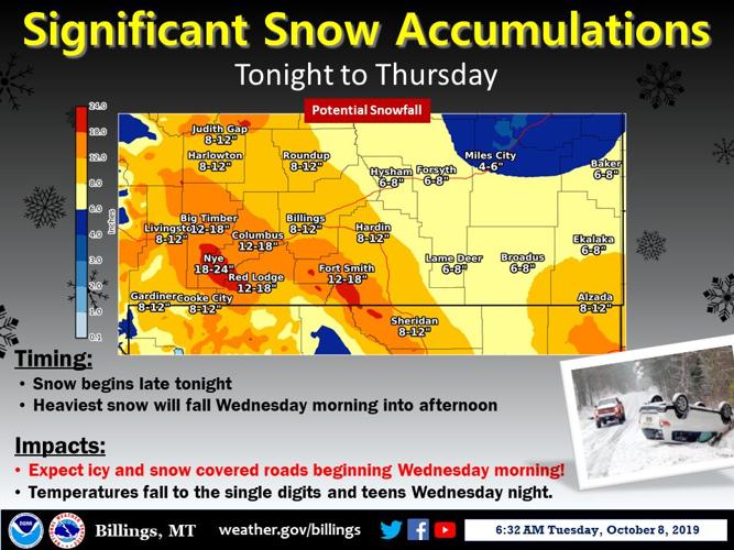
Significant snow accumulations will impact the area beginning late Tuesday night through Thursday. The heaviest snow will be Wednesday morning. Expect icy and snow covered roads beginning Wednesday morning with temperatures continuing to fall through the day into the single digits and teens by Wednesday night.
- National Weather Service Billings

Expect hazardous travel conditions on Wednesday, with icy and snow covered roads and poor visibility from heavy snowfall. The worst travel conditions will occur Wednesday morning. Give yourself extra time for your commute! Rain on Tuesday will change over to snow late Tuesday night into Wednesday morning, and snow will continue through the day on Wednesday. For travel information, call 511.
- National Weather Service Billings

A winter blast is expected Tuesday night through Wednesday. After a warm day Tuesday, with temperatures in the 60s and 70s, temperatures will fall into the 20s to low 30s Tuesday night. Highs on Wednesday will be only in the 20s and 30s, then temperatures will fall into the teens and single digits Wednesday night. Commutes will be challenging Wednesday and Thursday with icy roads and falling snow. There will be a slow warm-up through the weekend, dependent on snow cover.
- National Weather Service Billings

Strong southwest winds will continue to gust near 60 mph Tuesday morning, decreasing to gusts around 50 mph in the afternoon. Winds will diminish significantly behind a cold front late Tuesday afternoon into the evening. Dangerous crosswinds can be expected on I-90 near Livingston. High profile vehicles and those towing trailers should consider an alternate route or delay travel through this area until winds subside.
- National Weather Service Billings
More like this...
Significant snow accumulations will impact the area beginning late Tuesday night through Thursday. The heaviest snow will be Wednesday morning. Expect icy and snow covered roads beginning Wednesday morning with temperatures continuing to fall through the day into the single digits and teens by Wednesday night.
- National Weather Service Billings
Expect hazardous travel conditions on Wednesday, with icy and snow covered roads and poor visibility from heavy snowfall. The worst travel conditions will occur Wednesday morning. Give yourself extra time for your commute! Rain on Tuesday will change over to snow late Tuesday night into Wednesday morning, and snow will continue through the day on Wednesday. For travel information, call 511.
- National Weather Service Billings
A winter blast is expected Tuesday night through Wednesday. After a warm day Tuesday, with temperatures in the 60s and 70s, temperatures will fall into the 20s to low 30s Tuesday night. Highs on Wednesday will be only in the 20s and 30s, then temperatures will fall into the teens and single digits Wednesday night. Commutes will be challenging Wednesday and Thursday with icy roads and falling snow. There will be a slow warm-up through the weekend, dependent on snow cover.
- National Weather Service Billings
Strong southwest winds will continue to gust near 60 mph Tuesday morning, decreasing to gusts around 50 mph in the afternoon. Winds will diminish significantly behind a cold front late Tuesday afternoon into the evening. Dangerous crosswinds can be expected on I-90 near Livingston. High profile vehicles and those towing trailers should consider an alternate route or delay travel through this area until winds subside.
- National Weather Service Billings
More like this...
Locations
Local Weather
Currently in Billings
Success! An email has been sent to with a link to confirm list signup.
Error! There was an error processing your request.
Most Popular
Articles
- Yellowstone Co. tattoo artists urging people to get educated on rising tattoo trend
- Billings homicide victim ID'd Wednesday
- Billings stabbing leaves two teenager victims hospitalized Saturday
- Harriet Wilson's unsolved murder, six years later
- Inmate allegedly walked away from Gallatin County Re-Entry Program in Bozeman
- Montana's farmers can be impacted by the ever-changing weather
- High Wind Alerts for northwest MT last all day tomorrow
- Army National Guard held groundbreaking ceremony for new limited aviation support facility
- CRISP & GREEN brings healthy fast food options to Billings
- Jason Momoa makes special visit to Belgrade to greet fans and promote his MT-made Vodka brand
Videos


Billings, MT
Right Now
- Humidity: 53%
- Feels Like: 49°
- Heat Index: 52°
- Wind: 7 mph
- Wind Chill: 49°
- UV Index: 5 Moderate
- Sunrise: 06:10:12 AM
- Sunset: 08:14:52 PM
- Dew Point: 35°
- Visibility: 8 mi
Today
Mainly cloudy. A few peeks of sunshine possible. A stray shower or thunderstorm is possible. High 69F. Winds N at 5 to 10 mph.
Tonight
Cloudy with occasional showers overnight. Low 49F. Winds WNW at 10 to 15 mph. Chance of rain 40%.
Tomorrow
Cloudy skies. Slight chance of a rain shower. High 57F. Winds NNW at 10 to 15 mph.
Chance of Rain: 15%
Sunrise: 06:10:12 AM
Sunset: 08:14:52 PM
Humidity: 39%
Wind: N @ 9 mph
UV Index: 5 Moderate
Thursday Night
Cloudy with occasional showers overnight. Low 49F. Winds WNW at 10 to 15 mph. Chance of rain 40%.
Chance of Rain: 24%
Sunrise: 06:08:36 AM
Sunset: 08:16:10 PM
Humidity: 57%
Wind: NNW @ 12 mph
UV Index: 3 Moderate
Friday Night
Mostly cloudy. Low near 45F. Winds NNW at 10 to 15 mph.
Chance of Rain: 11%
Sunrise: 06:07:01 AM
Sunset: 08:17:27 PM
Humidity: 44%
Wind: ENE @ 16 mph
UV Index: 5 Moderate
Saturday Night
Partly to mostly cloudy. Low 43F. E winds shifting to NW at 10 to 20 mph.
Chance of Rain: 11%
Sunrise: 06:05:28 AM
Sunset: 08:18:44 PM
Humidity: 47%
Wind: NW @ 11 mph
UV Index: 6 High
Sunday Night
Partly cloudy during the evening. A few showers developing later during the night. Low around 45F. Winds W at 5 to 10 mph. Chance of rain 40%.
Chance of Rain: 75%
Sunrise: 06:03:56 AM
Sunset: 08:20:01 PM
Humidity: 48%
Wind: W @ 14 mph
UV Index: 6 High
Monday Night
Rain showers early with clearing later at night. Low near 40F. Winds WNW at 10 to 20 mph. Chance of rain 50%.
Chance of Rain: 6%
Sunrise: 06:02:26 AM
Sunset: 08:21:18 PM
Humidity: 36%
Wind: WNW @ 15 mph
UV Index: 6 High
Tuesday Night
Partly cloudy. Low 39F. Winds WNW at 10 to 20 mph.
Chance of Rain: 2%
Sunrise: 06:00:57 AM
Sunset: 08:22:34 PM
Humidity: 32%
Wind: WNW @ 11 mph
UV Index: 6 High
Wednesday Night
Partly cloudy. Low near 45F. NE winds shifting to W at 10 to 15 mph.
Get up-to-the-minute news sent straight to your device.