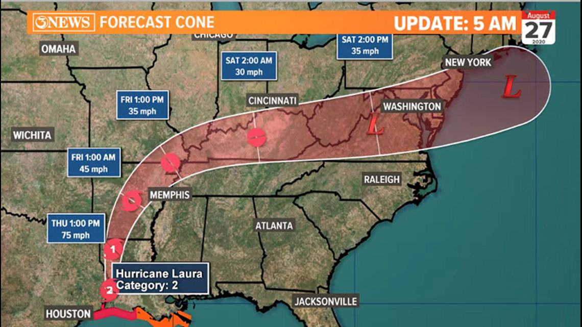
CORPUS CHRISTI, Texas — Thursday, 5AM:

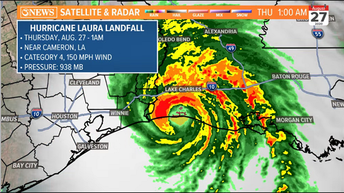
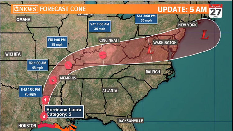
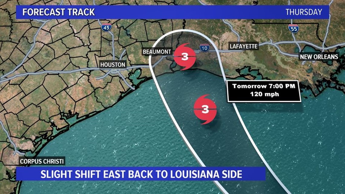
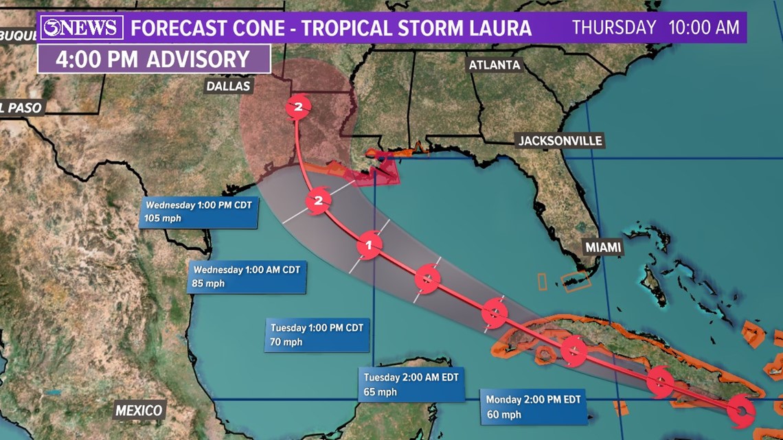
Laura made landfall as a category 4 hurricane near Cameron, LA, at 1am Thursday. Sustained winds at 150 mph with higher gusts and a central pressure of 938mb. Laura will maintain forward speeds and weaken to a tropical storm today as it moves in to Arkansas. Laura will turn east and become a remnant low over the mid-Atlantic this weekend.

10pm update Landfall imminent. Cat 4 Hurricane Laura 30 miles from Cameron, LA. 150 mph wind
4:00 pm update #BREAKING #NEW Hurricane Laura forecast 150 mph at landfall tonight. Strong Cat 4. Current wind 145 mph. Watch @kiii3news at 5,6,&10 http://www.kiiitv.com/weather
Update 1:30 PM
TROPICAL UPDATE: Laura is now a Category 4 hurricane pushing closer to the TX-LA border. Join 3News meteorologist Ryan Shoptaugh as he gives the latest updates.
Update: 10am
This is the messaging coming for the National Hurricane Center about Laura’s storm surge near the center of the forecast path - “unsurvivable”.

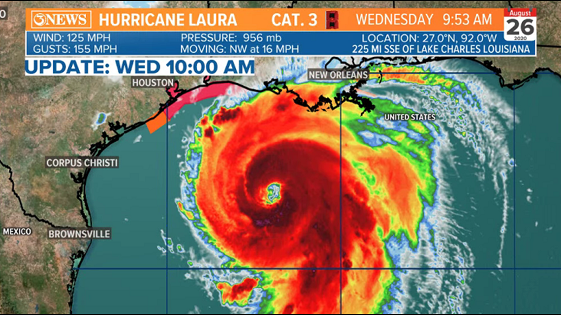
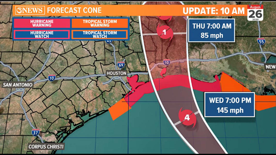
Major Hurricane Laura continues to strengthen; now approaching category 4 strength with 125mph sustained winds. Laura is moving NW at 16mph and is forecast to make landfall late Wednesday night or early Thursday morning just east of the TX/LA state line as a major hurricane. Storm surge east of where the center of the storm moves in could rise to 15-20 ft., given Laura's intensification/track.


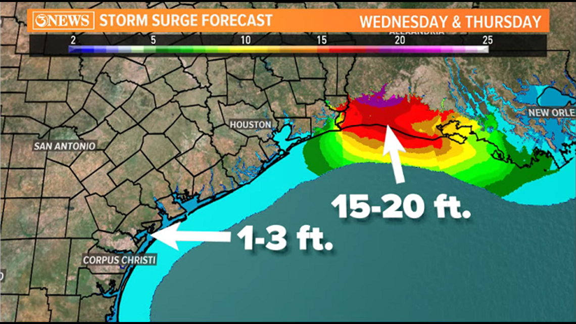
Laura does not pose a direct threat to the Coastal Bend. Effects will be coastal. Waves as high as 9-11 ft., longer period swells, 1-3 ft. surge, coastal flooding, rough surf, and high rip current risk.
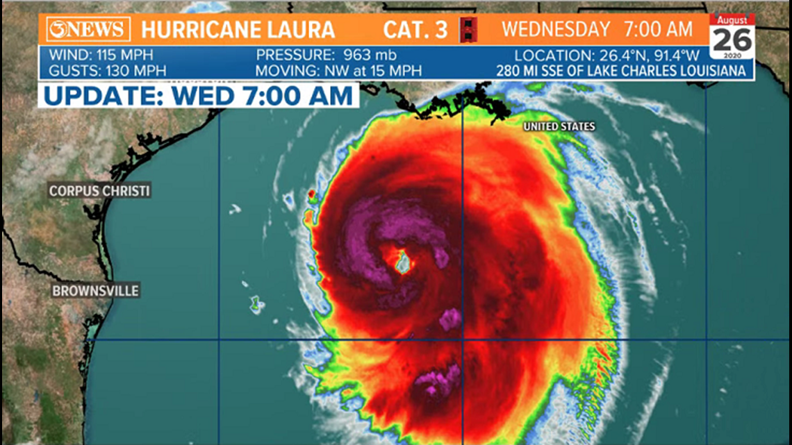
Update: 7am
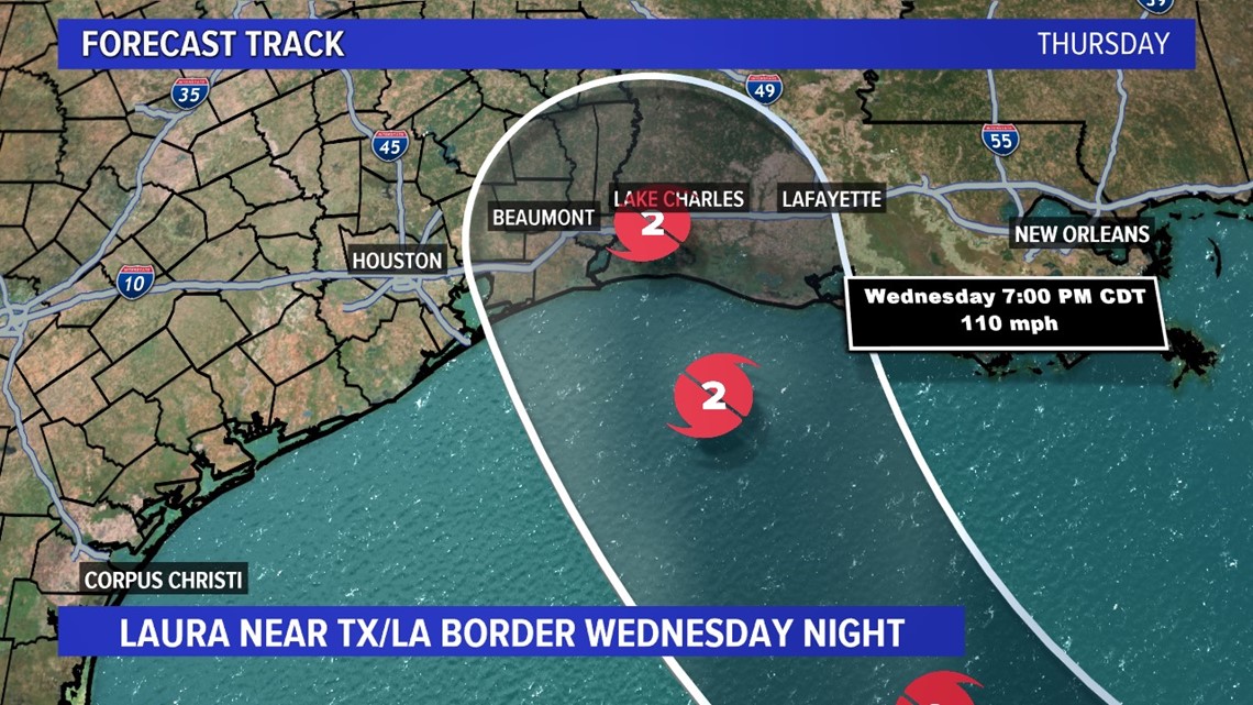
Laura has become the first major hurricane of the 2020 season, reaching category 3 status. Laura will make landfall tonight, near the TX/LA state line as a major hurricane.

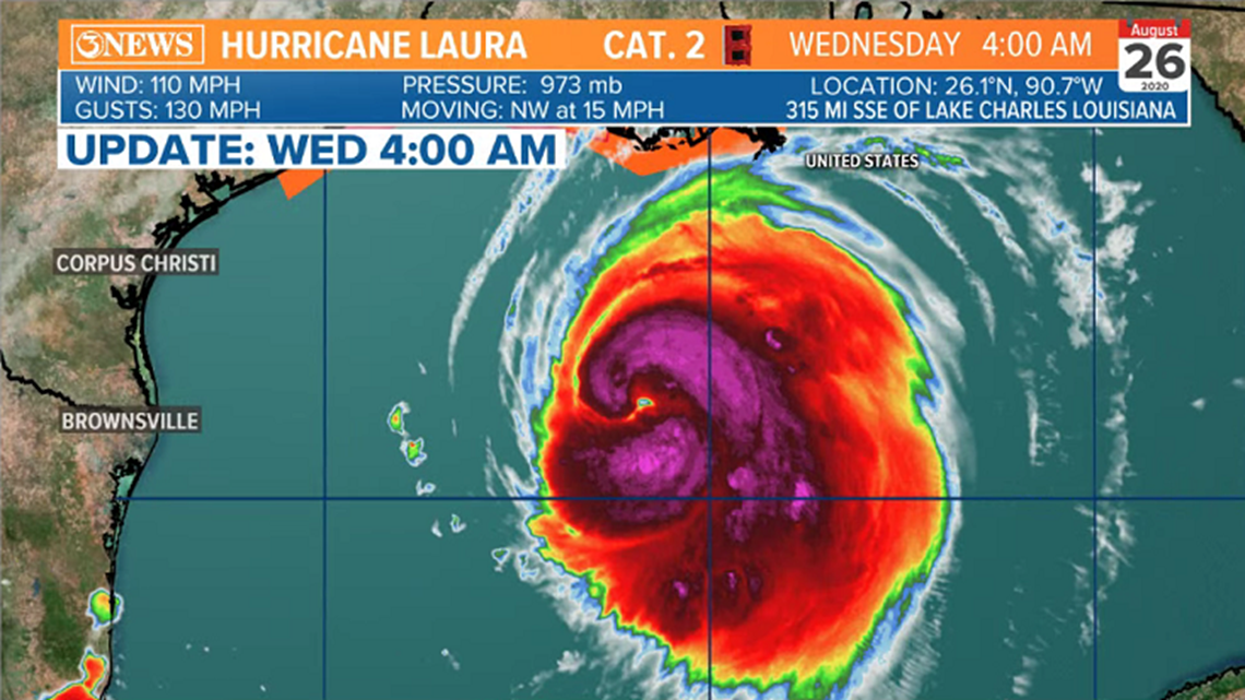
Update: 4am
Hurricane Laura continues to intensify. Now, a category 2 hurricane with 110 mph sustained winds. Satellite presentation looks much more like a healthy hurricane this morning. Moving NW at 15 mph.

Laura is forecast to strengthen to a major category 4 hurricane prior to landfall Wednesday night/Thursday morning near the Texas/Louisiana state line. Storm surge could reach 10-15ft. east of the center of where Laura moves in. 10-15" of rain, too. Laura will not stall, moving inland quickly.

Laura is NOT a threat to the Coastal Bend. We will see coastal effects. Waves could get as large as 9-11 ft. on area beaches Wednesday and Thursday. Longer period swells will lead to very dangerous rip currents. Coastal flooding is expected with an inundation of 1-3ft. thanks to higher than normal tides. A coastal flood advisory is in effect until 7PM, Thursday.
Alan
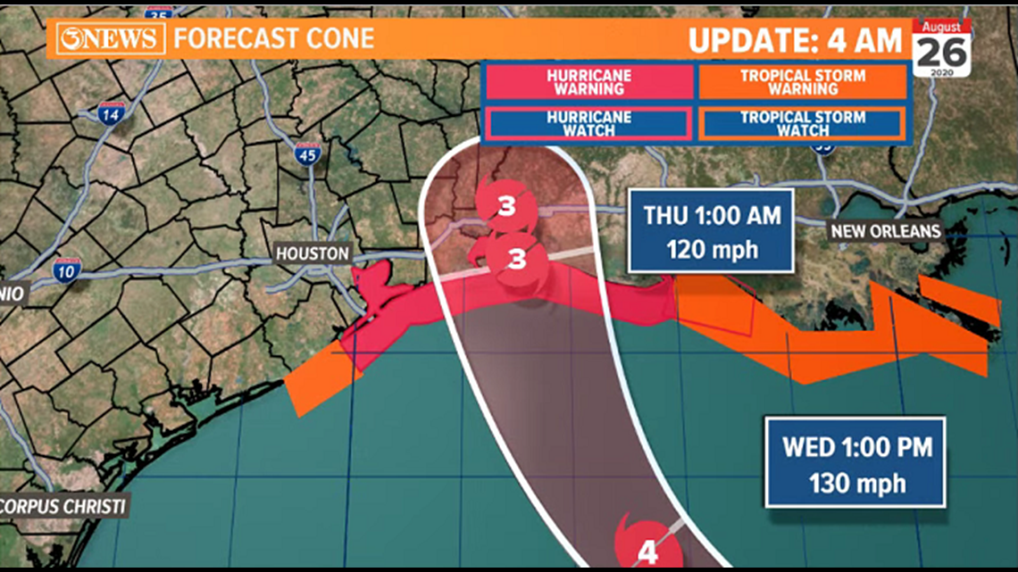
UPDATE: 10 p.m.
Forecast cone shifts slightly east. Peak forecast wind now 120 mph.

Tuesday evening tropical update with Meteorologist Bill Vessey via Facebook Live:
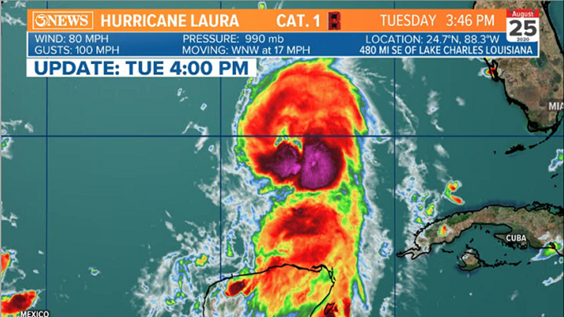
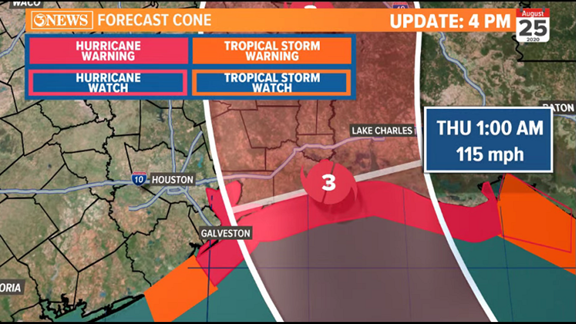
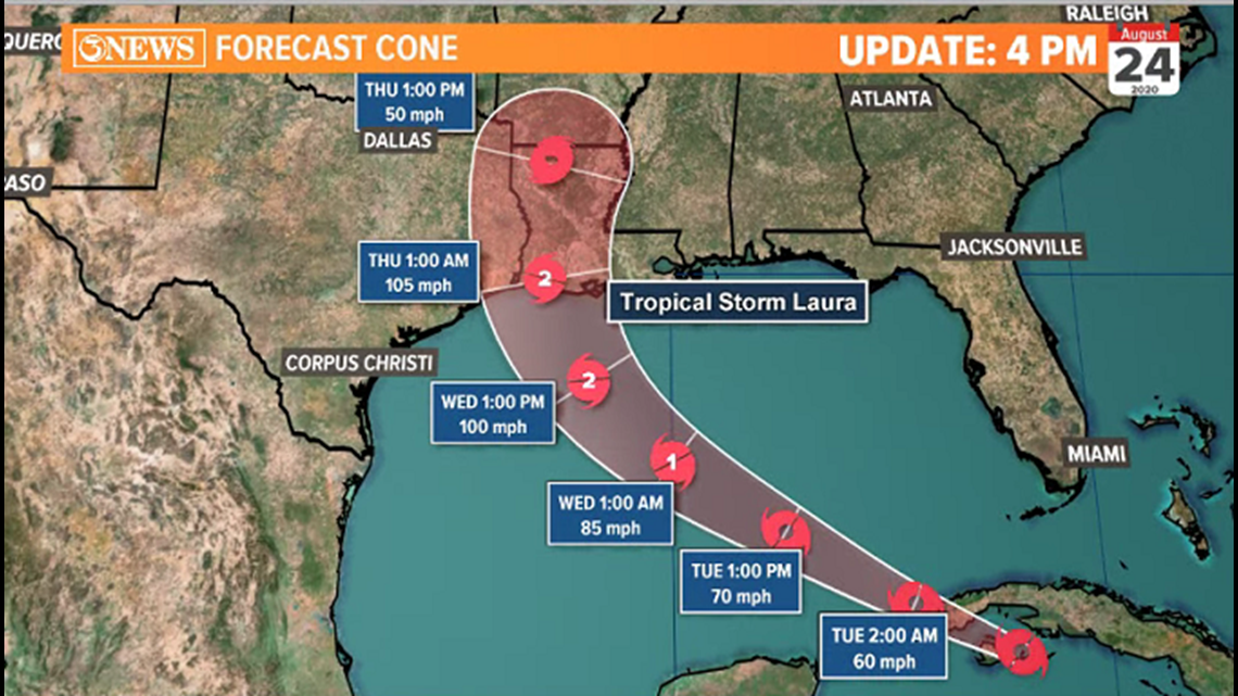
Tuesday, 4PM
Laura is a strengthening hurricane, now with 80 mph winds and 100 mph gusts. Laura is moving WNW at 17 mph.


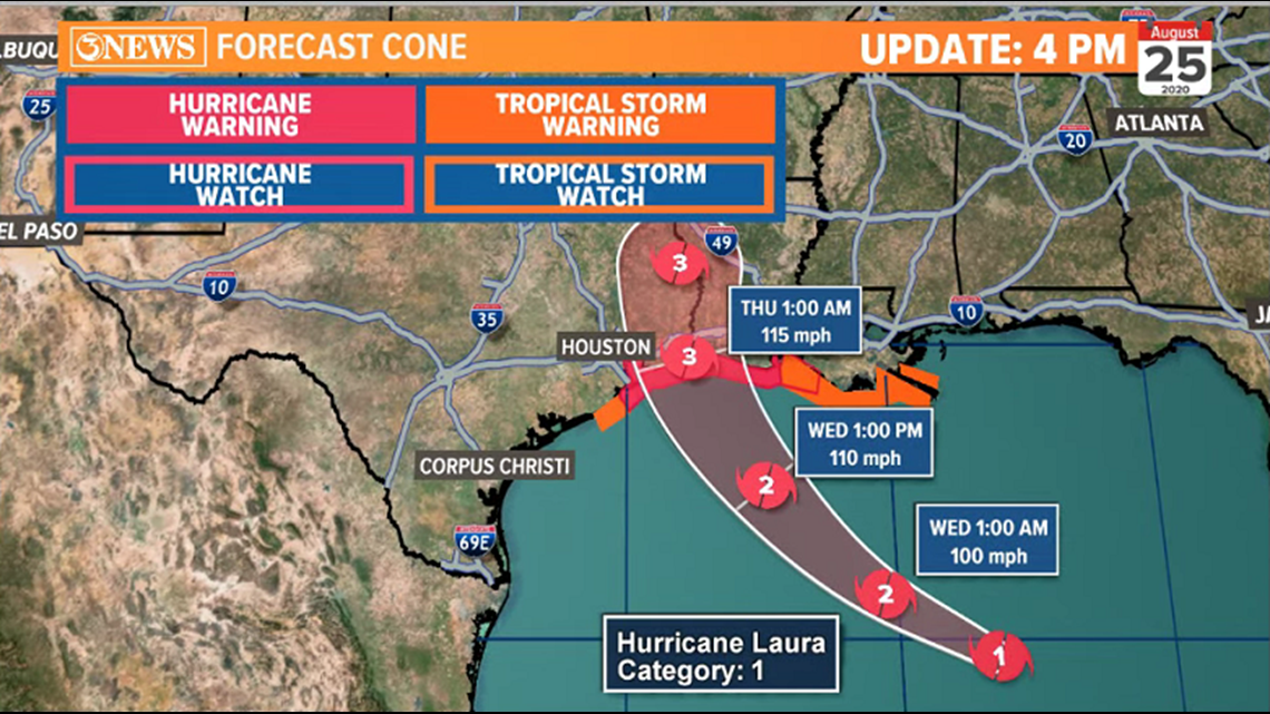
There's hardly any westerly shift in the 4pm NHC forecast cone, placing Laura near the TX/LA state line Wednesday night/early Thursday morning as a category 3, major hurricane at landfall. Devastating wind and storm surge the primary threats. Heavy rain, yes, as much as 15”; but Harvey-like flooding... not so much. The storm is forecast to maintain its forward speed after landfall.

The European forecast model is a little farther west of the current forecast cone, but not by much...still in SE Texas. The hurricane center makes note of this in their forecast, leaving the forecast door open for the possibility of a slight westward shift in the current forecast cone.

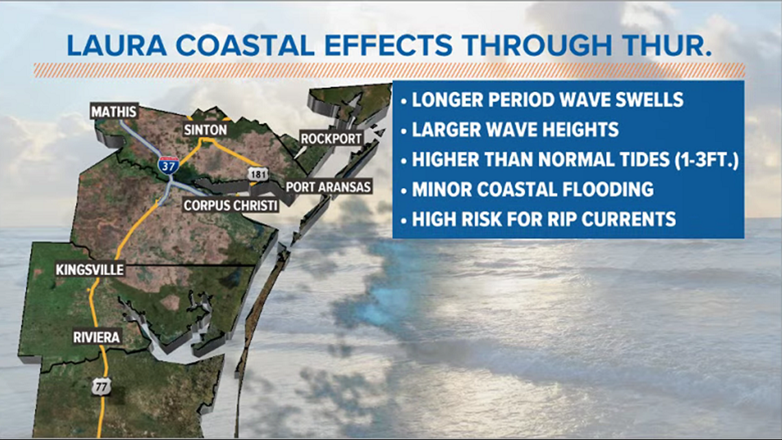
At this point, it looks like a storm for SE Texas and W Louisiana, sparing the Coastal Bend. The South Texas coastline will experience minor coastal side effects. Larger waves, longer period swells, and higher than normal tides (1-3 ft.), will lead to coastal flooding on area beaches. Rip current risk will be very high, given the rough surf Laura will create as it passes by a few hundred miles off-shore, Wednesday.
Tuesday, 10:30 AM
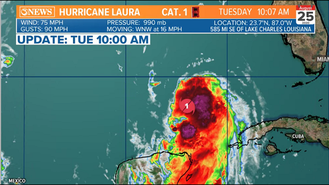
Tuesday, 10am


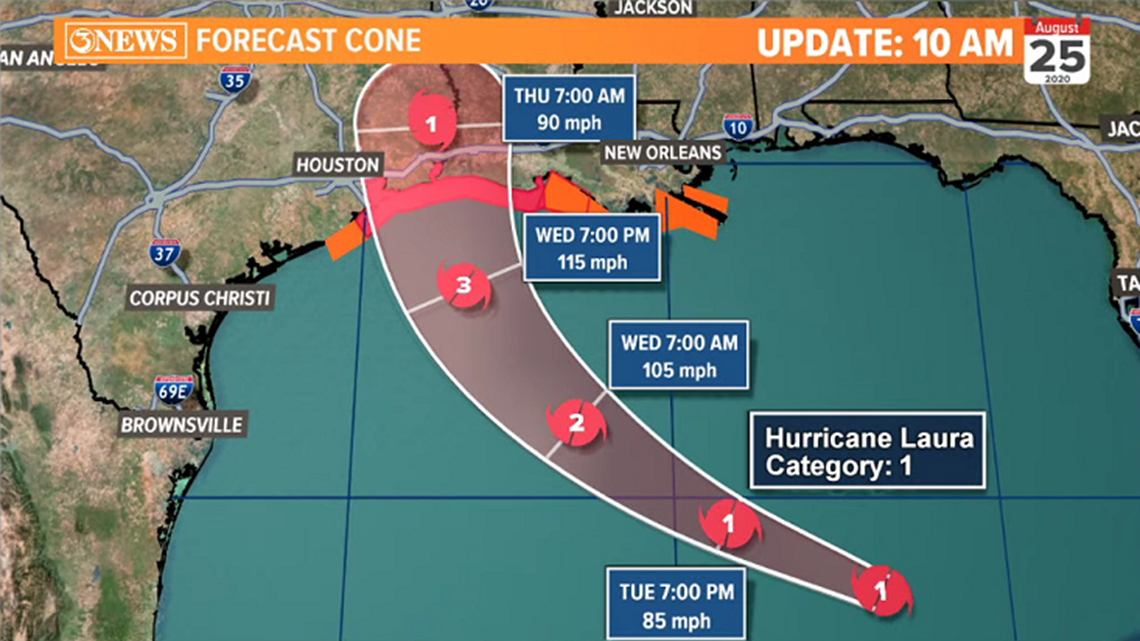
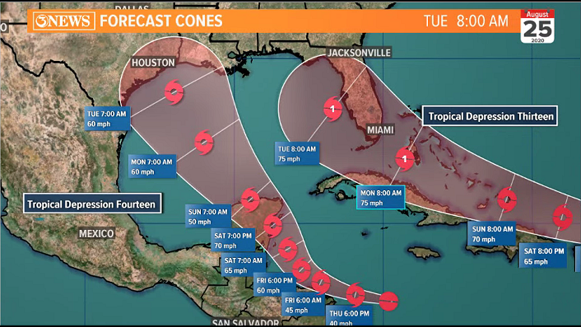
The 10A update from the National Hurricane Center keeps the center of the forecast cone aimed at the Texas/Louisiana state line. It extends as far west as the I-45 corridor between Houston and Galveston. Landfall Wednesday night/Thursday morning with category 3 strength winds - 115 mph, sustained.
Tuesday, 8:30am
There's a lot happening on this chart, but I made it as a 'catch all' to try and answer the questions on the westerly shift possibilities with respect to Laura's eventual track.

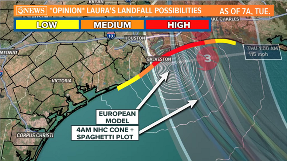
The yellow/orange/red lines represent MY OPINION on where the most likely forecast track of the center of Laura will be at landfall. Note, that it is displaced farther west from the center of the NHC's cone. My yellow, lower likelihood color extends as far south/west as about Freeport, TX. Again, this is my opinion and SHOULD NOT discount or over-ride the official NHC Forecast Cone. They do a fantastic job and are the gold standard.
I layered the 4AM National Hurricane Center forecast cone, spaghetti plot, and where the European model has Laura at landfall. The trend has been a westerly nudge the last few days. We'll see if that continues with the 10AM NHC update.
This is chart was made 7AM, Tuesday, Aug. 25, and is for the Wednesday night/Thursday morning landfall of Laura
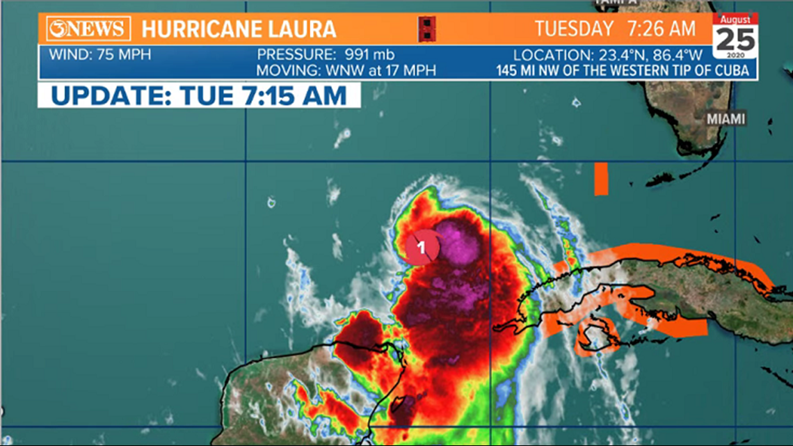
Tuesday, 7am
Laura has become a hurricane in the SE Gulf of Mexico. Moving WNW at 17 mph and 75 mph sustained winds.

Tuesday, 4AM Tropical Update:
Slight west shift and Laura now forecast to become a major hurricane prior to landfall.

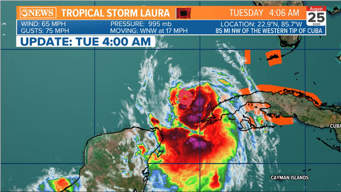
Tropical storm Laura is now entering the Gulf of Mexico and moving away from Cuba. Winds have increased to 65 mph and Laura will strengthen quickly, moving into the open gulf today. Laura is forecast to reach hurricane status today, category 2 status, Wednesday, and category 3, major hurricane status Wednesday night before landfall early Thursday morning.

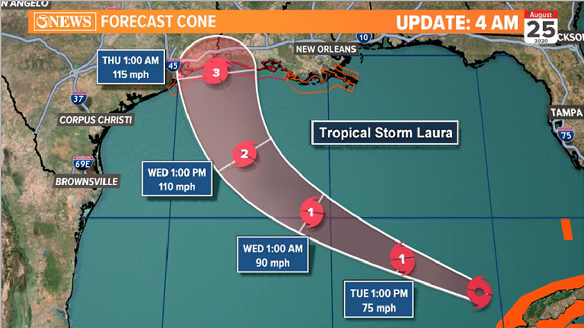
There has been a lot of debate on when/where Laura will make the north bend prior to landfall. confidence is growing in the SE TX/Western Louisiana Coastline and this update does have a slight west shift; now focused right at the TX/LA state line. There is some fairly reliable guidance - namely the Euro - that is still a bit farther west, toward Houston. SE Texas needs to be on high alert today and Wednesday for any slight shifts west.
For the Coastal Bend, this track would mean mainly coastal effects. Larger waves, dangerous rip currents, and coastal flooding. Some shower activity off the west flank of Laura Wednesday and Thursday as Laura passes by 200-300 miles off-shore, depending on the track.
-Alan Holt
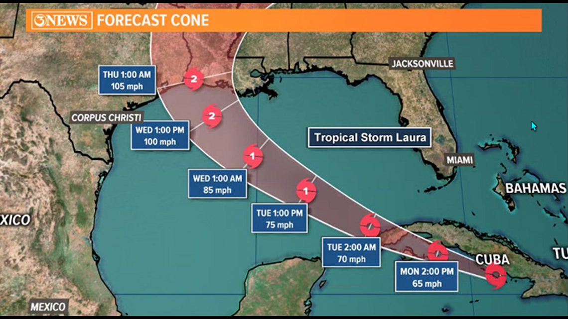
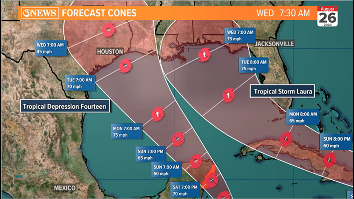
UPDATE: August 24 - 10 p.m.
Cone shifts a little bit more into Texas. Laura close to a category 3 major hurricane at landfall Wednesday night.

Monday evening tropical update with Meteorologist Bill Vessey.
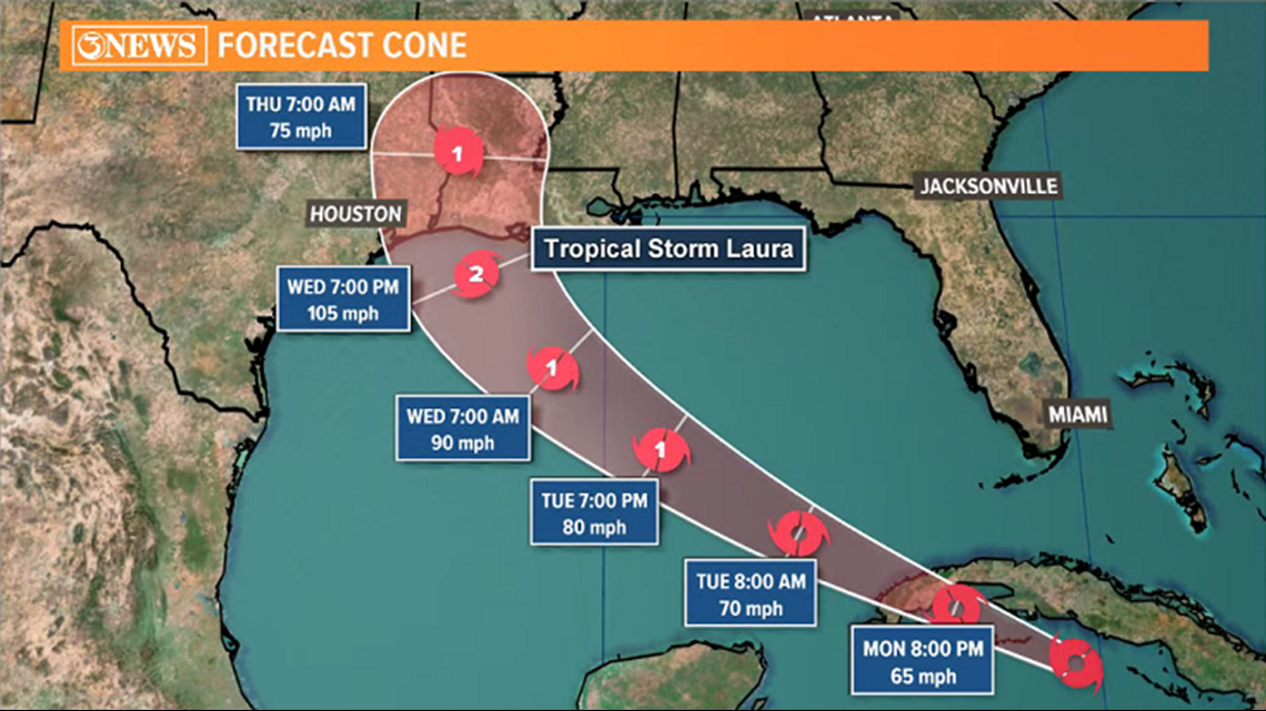
Monday, 4PM Tropical Update
Laura remains a tropical storm in the NW Caribbean with minimal change to the forecast cone.
Laura is forecast to move into the Gulf of Mexico, Tuesday, where intensification will take place. Laura is forecast to reach category 2 strength and bend north, Wednesday; pivoting around an area of high pressure over the SE US. That turn would place Laura near the TX/LA border Wednesday night, where it would make landfall as a category 2 hurricane. That's only about 48-60 hours from now. The National Hurricane Center is also expressing some uncertainty in the forecast cone closer to landfall.

A lot still depends on how Laura is structured and where Laura is located after moving into the Gulf of Mexico. There are some reliable forecast models that are a bit farther south and west than the National Hurricane Center's forecast cone - specifically, the European.
The NHC addresses this discrepancy in their forecast discussion of Laura's path. I've been fielding questions about this as well. Keep close watch on how this forecast evolves in future updates; especially after Laura gets into the Gulf.
As of right now, have a plan in place so that if the forecast does start to shift west, you can execute. It isn't time to act on plans at this time in the Coastal Bend.
Monday, 10AM Tropical Update
Laura remains a tropical storm in the NW Caribbean, just south of Cuba. The 10am forecast cone is close to previous update.

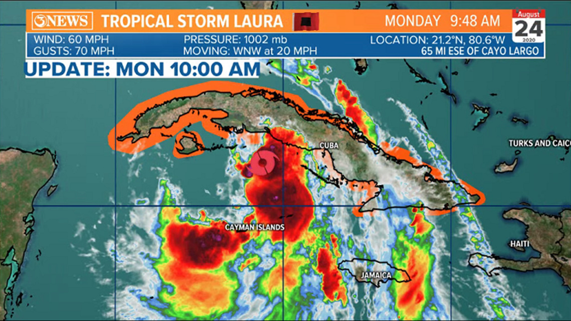
Laura is forecast to enter the Gulf of Mexico, Tuesday. Sea-surface temperatures and wind shear will both be favorable for intensification. Laura is forecast to strengthen to a category 2 hurricane before bending north and making landfall near the TX/LA border, Wednesday night.

Some notes: The location and structure of Laura after Cuba will be critical in the forecast track and intensity in the Gulf of Mexico. Models have been having a difficult time locating the center of the storm, leading to perhaps some initial placement errors. There are some forecast models that are still trending farther west of the current forecast cone. The forecasts today and tomorrow need to be watched very closely to see if there's any westerly shifting of the cone. Be sure to stay up to date with the most current information.
Marco not a threat to the Coastal Bend.
-Holt, out
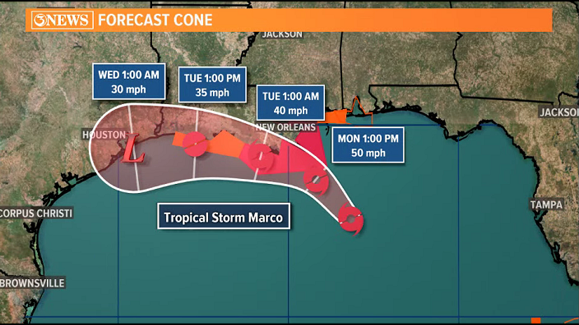
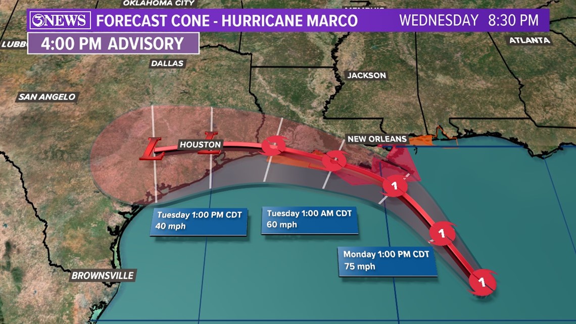
Monday, 4AM Tropical Update
Tropical Storm Marco will scrape by the Louisiana coast Monday and Tuesday, weakening to a remnant low over SE Texas by Wednesday. The landfall aspect of Marco is interesting because it may not make landfall as it sits just off-shore and weakens, drifting west. If it does make it over land it would likely be in Louisiana somewhere. No threat to the Coastal Bend.


Tropical Storm Laura will pass south of and over Cuba today, entering the Gulf of Mexico, Tuesday. Laura's health after Cuba will play a role in both forecast track and intensity Tuesday and Wednesday. Laura is expected to move northwest, through the Gulf of Mexico around a high pressure feature in the southeast US. Despite Marco being in the gulf just a few days prior, both wind shear and gulf waters will be favorable for intensification. As Laura gets to the western periphery of the high, there should be a bend to the north, sending Laura toward to TX/LA state line as a category 2 hurricane Wednesday night.


There is some confidence growing in both the forecast track and intensity outlook of Laura. Still no need to take action in the Coastal Bend given these trends. Stay up to date with current forecasts in order to make the best preparation decisions possible.
- Alan Holt
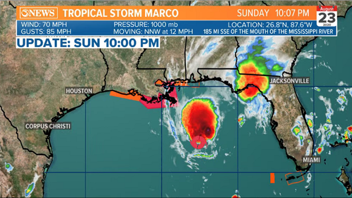
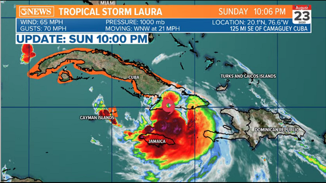
UPDATE: August 23- 10 p.m.
Marco downgrades to a Tropical Storm from a Category 1 Hurricane
Max winds at 70 MPH
UPDATE: August 23- 7 p.m.
Hurricane Marco max winds at 75 MPH
Moving NNW at 13 MPH
Updated forecast cone shows Marco weakening as it approaches the LA coast as a Tropical Storm
Making landfall Monday night into early Tuesday somewhere along the southwestern coast of Louisiana
Tropical Storm Laura
Max winds up to 60 MPH
Moving WNW at 21 MPH
Over the southern coast of Cuba tonight


UPDATE: August 23- 4 p.m.
Tropical Storm Laura:
AIR FORCE HURRICANE HUNTER AIRCRAFT FINDS A SLIGHTLY STRONGER LAURA JUST SOUTH OF EASTERN CUBA
HEAVY RAINFALL AND LIFE-THREATENING FLASH FLOODING LIKELY OVER THE DOMINICAN REPUBLIC, HAITI, CUBA, AND JAMAICA
Hurricane Marco:
MAXIMUM SUSTAINED WINDS...75 MPH...120 KM/H PRESENT MOVEMENT...NNW OR 340 DEGREES AT 13 MPH
UPDATE: August 23- 1 p.m.
Marco upgrades into a Category 1 hurricane. Still expected to push into SE Louisiana
UPDATE: August 23- 12:30 p.m.
Marco upgraded to a hurricane with 75 mph winds, and Tropical Storm Laura continues to soak Haiti as it heads towards Cuba.
UPDATE: August 23 - 10 a.m.
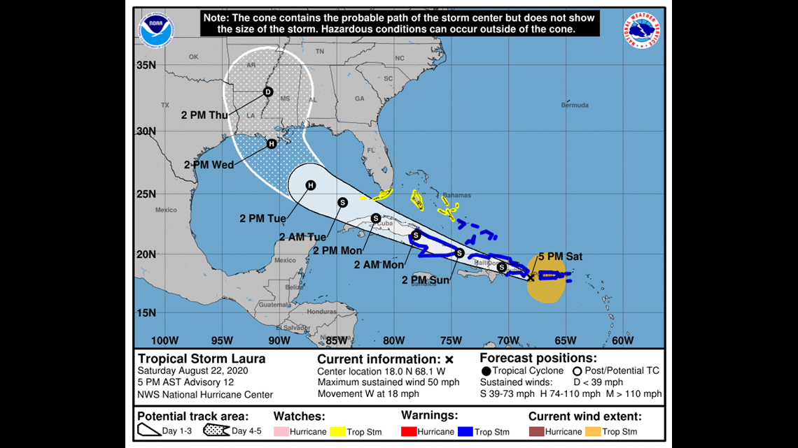
Both Tropical Storm Marco and Laura continue to strengthen
The forecast cone for Tropical Storm Laura has shifted to the west which includes Southeast Texas and Houston. This cone will continue to shift slightly until Laura makes landfall next week
Max winds for TS Laura is 50 MPH
Moving WNW at 21 MPH over the northern Caribbean
Tropical Storm Marco still expected to push into SE Louisiana Monday
UPDATE: August 23 - 7 a.m.
Tropical Storm Marco is nearing hurricane strength
Max winds are up to 70 MPH
Hurricane Watches and Warnings in effect for Louisiana
Tropical Storm Laura expected to strengthen when pushing into the Gulf
Both tropical storms are expected to make landfall between Mon - Wed
UPDATE: August 22 - 10 p.m.
A Storm Surge Watch is in effect for... * Sabine Pass to the Alabama/Florida border * Lake Pontchartrain, Lake Maurepas, Lake Borgne, and Mobile Bay
A Hurricane Watch is in effect for... * Intracoastal City Louisiana to the Mississippi/Alabama border * Lake Pontchartrain, Lake Maurepas, and Metropolitan New Orleans
A Tropical Storm Warning is in effect for... * Province of Pinar del Rio Cuba
A Tropical Storm Watch is in effect for... * Mississippi/Alabama border to the Alabama/Florida border

UPDATE: August 22 - 4 p.m.
Forecast cone has shifted to the east closer to Louisiana as of this last update from the National Hurricane Center
If this forecast verifies, both Marco and Laura will impact Central and Eastern Louisiana Monday through Wednesday as Category 1 Hurricanes.
STORM SURGE AND HURRICANE WATCHES ISSUED FOR THE NORTHERN GULF COAST
Tropical Storm Marco has sustained winds of 65 MPH and moving NNW at 13 MPH
A Storm Surge Watch has been issued from Sabine Pass eastward to the Alabama/Florida border, including Lake Pontchartrain, Lake Maurepas, Lake Borgne, and Mobile Bay.
A Hurricane Watch has been issued from Intracoastal City Louisiana eastward to the Mississippi/Alabama border, including Lake Pontchartrain, Lake Maurepas, and Metropolitan New Orleans.

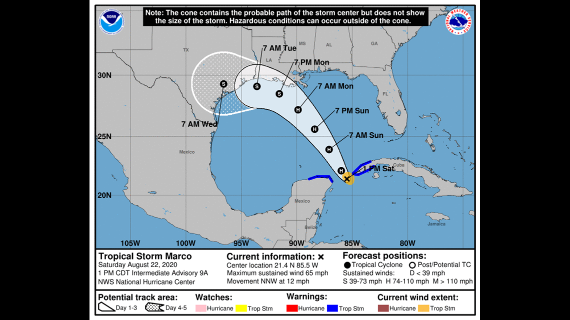
UPDATE: August 22 - 1 p.m.
Tropical Storm Marco sustained winds 65 MPH
Continues to move NW at 12 MPH
Additional strengthening is expected through Sunday
Forecast cone heads towards LA and bends west-northwest closer to Houston
Tropical Storm Laura sustained winds at 50 MPH
Moving W at 18 MPH
Expected to push over land through Monday which will keep it fairly weak
Expected to strengthen afterwards into a Category 1
UPDATE: August 22 - 10 a.m.
Tropical storm continues to strengthen
Closing in on hurricane strength with sustained winds at 65 MPH
Expected to become a hurricane soon
UPDATE: August 22 - 7 a.m.
Tropical Storm Marco currently has max winds at 50 MPH
Minimum Central pressure at 1002 mb
Moving NW at 12 MPH
UPDATE: August 21 - 10 p.m.
Tropical Storm Marco (formerly Tropical Depression 14) has formed in the Caribbean Sea.

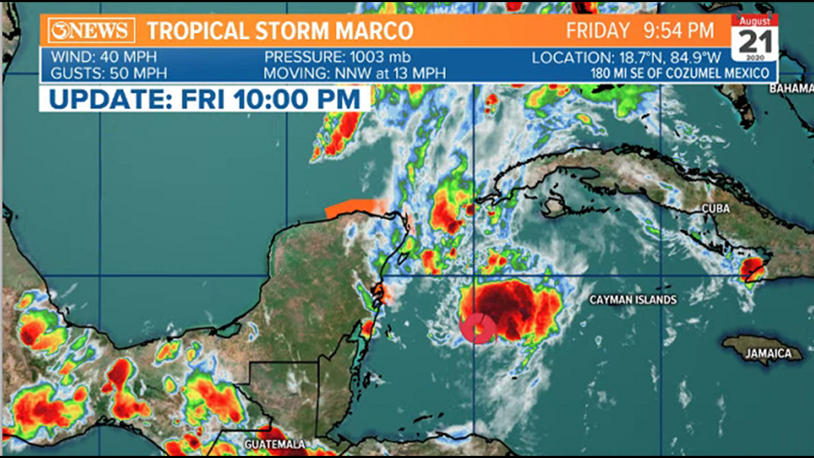
Tropical Depression 14 is now Tropical Storm Marco.
Forecast cone still includes most of the Texas Gulf Coast, ALL of the Coastal Bend, and parts of Louisiana.
New update does not bring Marco to hurricane strength, making landfall as a tropical storm some time Tuesday evening.
Tropical Storm Laura is still forecast to become a hurricane, making landfall as a hurricane in the North Gulf Coast on Wednesday evening.
As discussed in previous posts, Laura looks to be the 'alpha' of the two storms.
For all of the folks on the Fujiwhara train, yes the forecast cones overlap; however, timestamps are important here. The two storms will be crossing close to the same locations, but a day apart (maybe more) from one another. There may be some minor play off of one another but these will be two separate, land falling Gulf storms within a day of one another.
We'll get more clarity on specifics about track and intensity over the weekend as we get to know the storms better, and refine the forecast. Know that the current forecast is not set in stone and will evolve/adjust a bit through the weekend.
Friday, August 21: Facebook Live with Meteorologist Bill Vessey 8:45 p.m.
UPDATE: August 21 - 6 p.m.
Some of the key influencers at play down the forecast road for Tropical Depression 14 and Tropical Storm Laura will be the placement of the Bermuda High and wind shear.
The Bermuda High is a large scale high pressure feature that is often located over or near Bermuda, hence the name.
The location of this high pressure can lead to hints on forecast path of tropical features down the road. Today, the forecast placement of the high has moved west, thus the westerly movement in both forecast cones at 4 p.m. update.
The location of this on Monday/Tuesday next week will be key to unlocking exact track.

In the image, I put the spaghetti plot for both tropical systems with mid level pressure on the map. Note the spread in the western gulf with TD 14. That screams low confidence on track.
With respect to intensity, on the 4 p.m. (Friday) forecast cones, you'll see that TD 14 weakens as it moves in to the northwestern gulf and TS Laura remains a hurricane in the northern gulf.

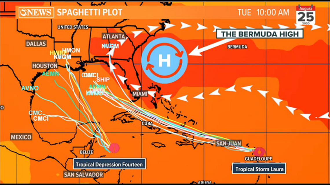
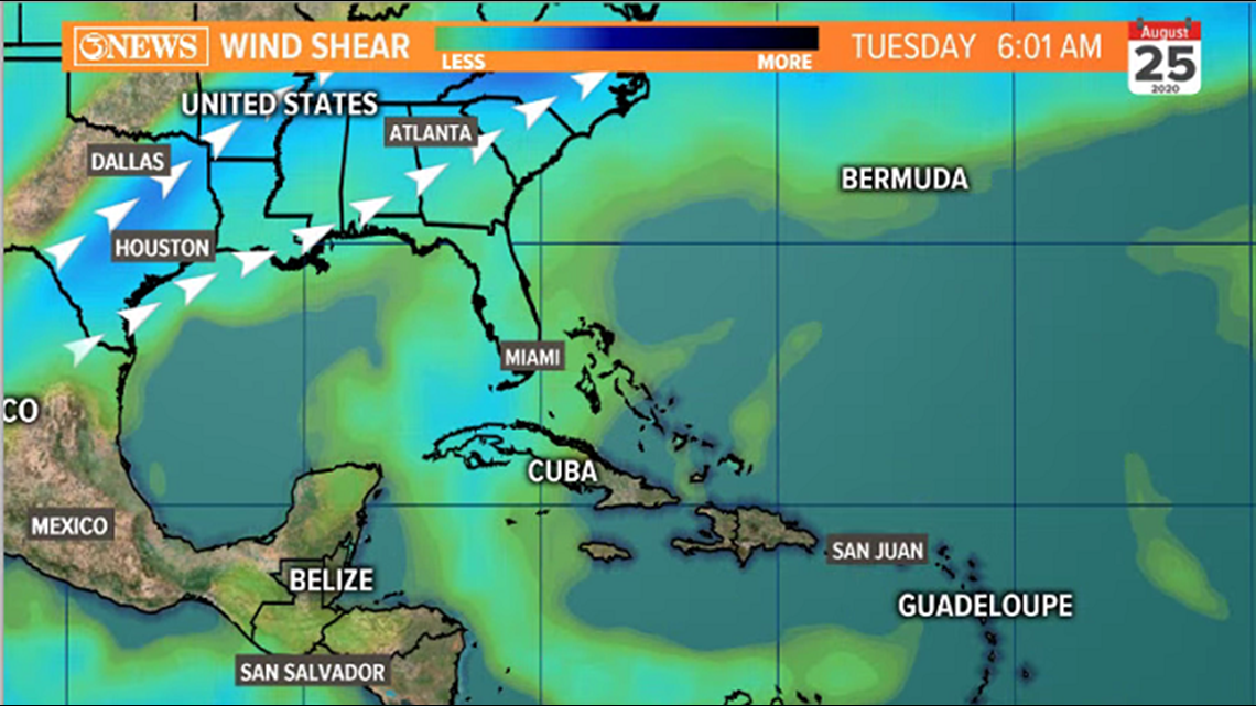
The reason weakening on TD 14 is noted in the forecast cone is likely because of some wind shear that is forecast to be in the NW gulf early next week. That should weaken whatever TD 14 is called as it moves into that region. You can see where the wind shear is forecast to be located on Tuesday morning in the shared image.
Based on this information, it looks like Laura will be the dominant feature (but not set in stone yet).
Forecast track and intensity are far from being nailed down. The cone/intensity forecast on both will likely shift around over the weekend. Stay up to date with the most current info for best planning.
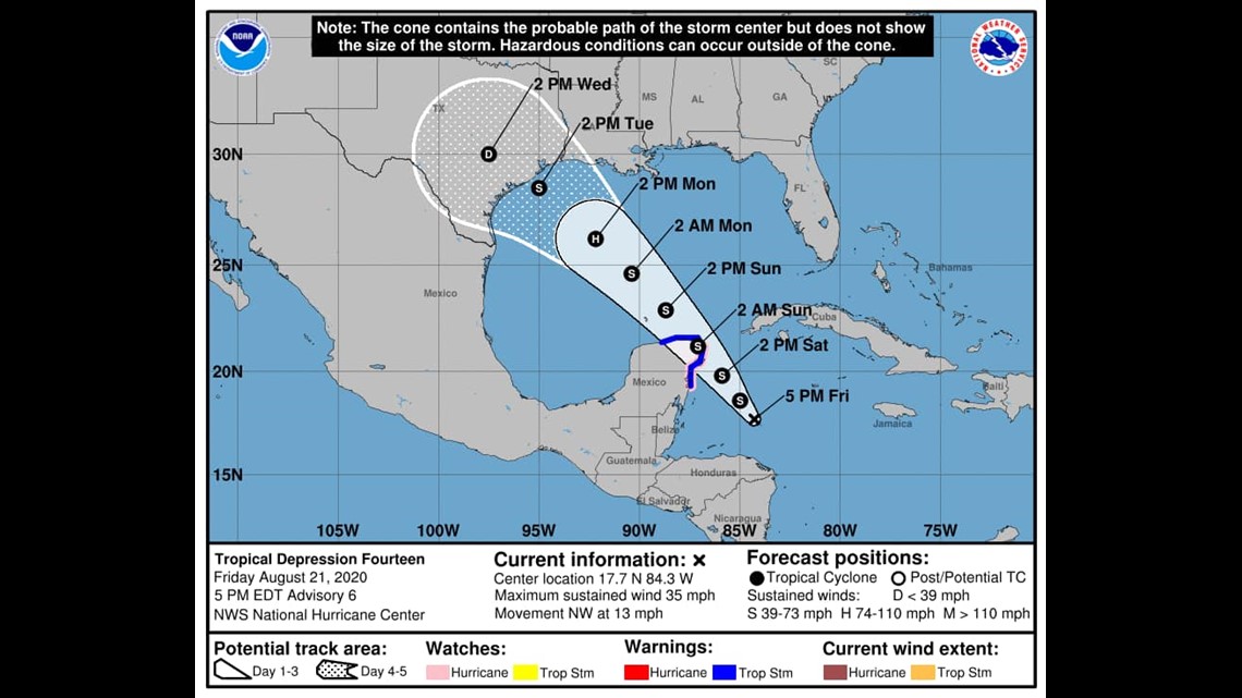
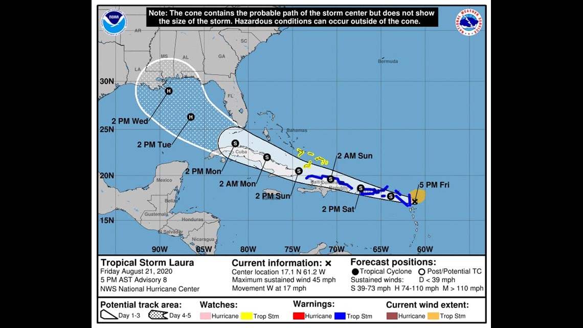
UPDATE: August 21 - 4 p.m.
New forecast cones on Tropical Depression 14 and Tropical Storm Laura show a noticeable westerly shift in track for both systems.
TD14 - almost all of Texas, including all of the Coastal Bend now inside the forecast cone. Parts of Louisiana, too. Forecast intensity is for tropical storm strength at landfall, Tuesday afternoon. May briefly attain hurricane status prior to landfall in the central gulf.

TS Laura is forecast to be the stronger storm, reaching hurricane status. Forecast to be a hurricane as it approaches the northern gulf coast Wednesday.
We’ve been talking about the high level of uncertainty given the dual systems moving into the same vicinity. Still 4-5 days out and we will likely see further shifts/adjustments on the forecast cones as these storms make their way into the gulf over the weekend and better data becomes available.

UPDATE: August 21 - 10 a.m.
New forecast cones from the National Hurricane Center show some intensity adjustments, but the forecast tracks staying close to previous cones.

Tropical Storm Laura is forecast to move into the Eastern Gulf of Mexico as a Hurricane next week; moving into the central or northeastern Gulf of Mexico Wednesday as a category 1 hurricane.
Tropical Depression 14 has a drop in the intensity forecast after reaching category 1 hurricane status in the Gulf. Interaction with some wind shear in the northwestern Gulf of Mexico is the likely reason for the drop to tropical storm status as it moves in to NW Gulf Coast Tuesday.
The forecast cones encompass nearly all of the Gulf of Mexico from Texas to Florida, indicating a degree of uncertainty. The entire Gulf Coast needs to be aware of the latest forecasts on these storms over the next few days as the forecast is likely to change. These are still 4-5 days away from a potential US landfall. Expect adjustments to be made.
UPDATE: August 21 - 4 a.m.
Another slight shift to the east for Tropical Depression 14 (the storm farther to the west). Both storms reaching hurricane status in the Gulf of Mexico early next week and making landfall on Tuesday. Forecast cones encompass from Corpus Christi through all of the west coast of Florida.

Given we are still 4-5 days away from these making landfall in the US, there will still be changes in the forecast track/intensity. Another consideration is that there may be some play off of one another if these storms get closer together. I do NOT believe these systems will merge, but there may be some track adjustments if they interact. All of the Gulf of Mexico needs to be on guard and ready to act.

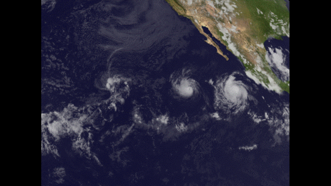
The Fujiwhara Effect (been fielding a lot of questions on this) is something that has been brought up. That's when two storms become close enough to start to circulate around one another and eventually the larger storm can ingest the smaller, becoming one storm. Yes, this has happened...but that process takes 5-7 days and you need a lot of geographic space. These two systems will be paralleling one another and will only be around each other for a day or two. So, we should have two separate landfalls. The Image above too place in the Pacific between July 25 and August 1
- Alan Holt
UPDATE: August 20 - 10 p.m.
The 10 p.m. update has two hurricanes in the Gulf of Mexico on Monday and Tuesday, both making landfall in the northern Gulf Tuesday night. Texas to Florida should be on high alert.
The exact track and intensity forecasts will shift as these are still five days out.
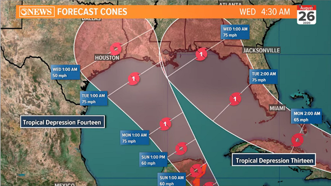
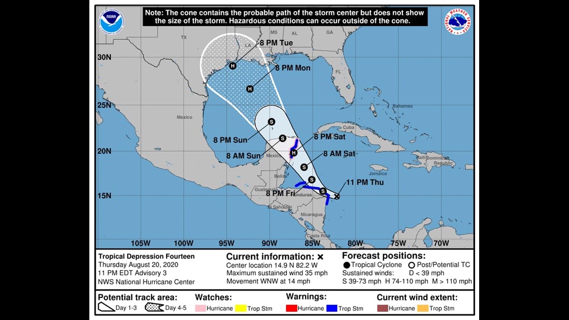
Tropical Depression 14

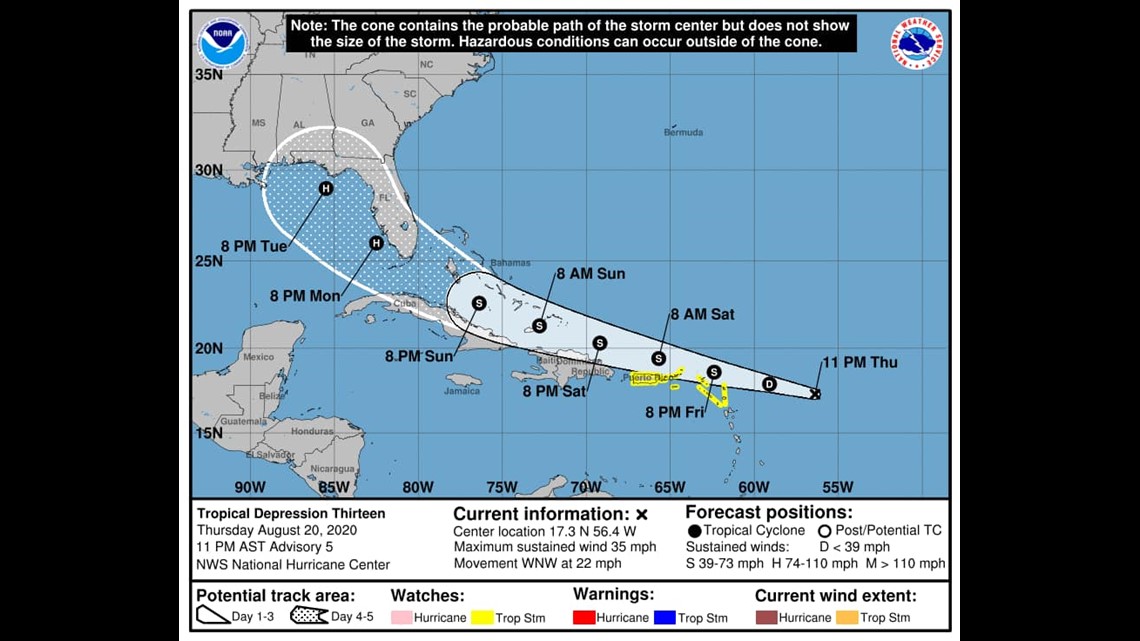
Tropical Depression 13

Thursday evening tropical update with Meteorologist Bill Vessey via Facebook Live.
UPDATE: 4 p.m.
Tropical Depression 13 has not strengthened. Tropical Storm Watch issued for the Virgin Islands and Puerto Rico.
Tropical Depression 14 Air Force Reserve Hurricane Hunter Aircraft finds the Depression a little farther south. Tropical Storm Warnings issued for portions of Honduras and Nicaragua.
REWATCH: Q&A with Meteorologist Alan Holt.
Invest 97L is now Tropical Depression 14 in the Caribbean Sea. It's moving west at 21 mph.

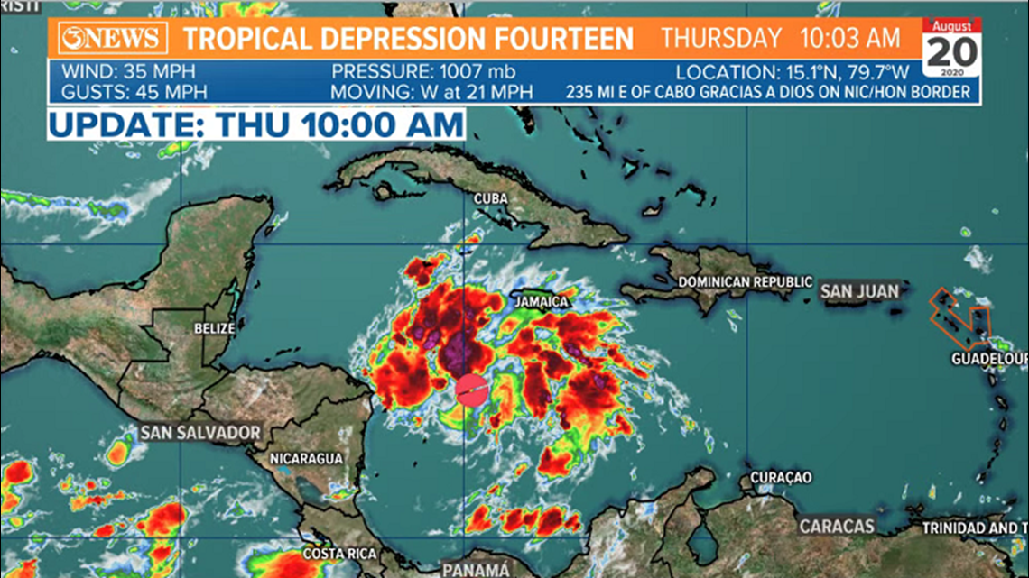
Forecast cone brings TD 14 to tropical storm strength in the Caribbean, prior to the Yucatan and keeps it at tropical storm strength as it tracks northwest, through the Western Gulf of Mexico. Moving in somewhere along the Texas/Louisiana coast on Tuesday of next week.

TD 13 in the Atlantic is now forecast to become a hurricane as it enters the Eastern Gulf early next week. At this point, I do not see that system as a threat for the Coastal Bend.
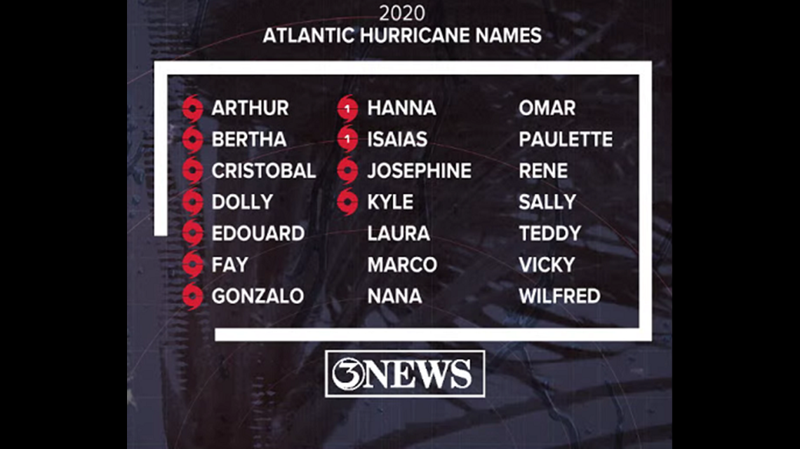
These will be Laura and Marco. The first to reach tropical storm status first will carry the L name. t is still too early to address specific land falling locations and impacts with both of these storms. The forecast will need to be adjusted as new and better information becomes available in the coming days. Stay tuned.