


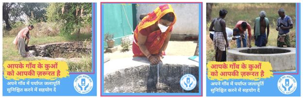
Starting May 15, 2022 Mamatha from Andhra Pradesh, and Rameshwar from Maharashtra, equipped with a mobile phone and a measuring tape, will be joining several others heading to their fields and neighbouring villages to measure wells. What they will be doing will contribute to the larger goal of measuring and managing India’s groundwater resources via the nation-wide Napo Jal Bachao Kal campaign.
Their plan is simple: measure their wells and upload the data via the Groundwater Monitoring Tool (GWMT) to better understand the situation of the local groundwater table. The GWMT is an open-source android tool, which enables collection of well water level data and its collation on a web platform for easy access by all.
Mamatha and Rameshwar will be one among 5,500+ individuals participating independently, or with 100+ NGOs across India in what is possibly the world’s largest crowdsourced groundwater monitoring project. Last year, 32,000+ wells were measured before and after the monsoons. The work of each of these individuals and organisations is crucial for the future of the world’s largest groundwater user– India.
India uses 25% of all groundwater extracted every year globally. 70% of agriculture and 85% of our drinking water supply depends on groundwater. A major component of the groundwater extracted (89%), is used in the irrigation sector, followed by domestic use (9%) and lastly industrial use (2%).
Owing to this alarming rate of extraction and usage, India is fast moving towards a crisis of groundwater overuse and contamination. Lack of good quality, location-specific data for most parts of the country hinders its sustainable management. Thus, there is an urgent need to shift from groundwater development to its management by identifying and mapping groundwater, quantifying the available potential, and proposing plans that can improve recharge and use of groundwater resources. A robust understanding of the state of groundwater in India will help in its management and governance at the local level.
A growing movement with a national goal
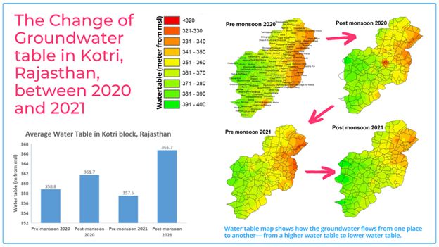
The number of participants and wells have been steadily growing over the past 2 years. “The aim of Napo Jal Bachao Kal,” according to Chiranjit Guha, the principal architect of the GWM Tool, “is to measure at least one well in each of the 6 lakh villages across India before and after the monsoons, year after year. This will give us a comprehensive insight into the status of groundwater at its lowest and highest levels. Having this information will help us better manage and govern our water resources. As an example, 430 wells have been measured in Kotri block of Rajasthan, providing a picture of the temporal changes of groundwater within the villages of the block. This has given us insights about the changing water levels in the villages, and helping in identification of villages where the decline in groundwater tables is acute. This aided our discussion with the communities to move towards better water governance practices.”
The collated data, by people like Mamatha and Rameshwar will all add to the rapidly growing database on the Groundwater Monitoring Portal, which is then used to generate visualizations of India’s water levels. For instance, data that has been collected by our partners and us in the past is able to point to “over-exploited” districts that are in dire need of help before full-scale drought potentially sets in. Data like this can be used to make citizen-level decisions as well as to inform policy.
This year too, 100+ NGOs, and 10s of 1000s of community members are coming together before the monsoons hit the subcontinent, to measure at least 50,000 wells across India. During the post-monsoon season in the past year, 32,000+ wells were measured and mapped, across 514 blocks in 12 states.
The background to Napo Jal Bachao Kal
“Consistent with our belief that water and knowledge should be accessible to all, we are happy to say that absolutely anyone and everyone can participate in the groundwater monitoring campaign and has free access to all the data generated. We hope that more and more people across the country join the campaign to generate sufficient data to improve decision making around usage of groundwater, thereby creating water self-sufficiency at all levels” said Sanjay Joshie, Executive Director, FES.
“This year, we are planning to increase the reach of the campaign to more villages across India by strengthening our state-wise strategies. We will be running the campaign in six regional languages– Hindi, Gujarati, Telugu, Marathi, Kannada and Odia– in addition to English. Beyond social media engagement like in the previous years, new participants will see the campaign on innovative grassroot media like auto-rickshaws decked in colourful posters and loudspeakers,” said Kiran Singh, Lead, Communications, FES.
“The goal is to engage participants that are well beyond the reach of traditional media, new media and also outside the direct networks of the 100+ partner organisations, including FES,” she added.
The Groundwater Monitoring Tool uses a standard methodology for data collection to ensure data quality. Addressing the inconsistency in existing datasets, the tool pools together data from various decentralised data repositories present with various NGOs and Community Based Organisations (CBOs), thus giving a more detailed picture of the groundwater level across the country.
Further, the primary data collected on ground by various organisations and individuals is combined with secondary data layers present on the India Observatory platform to improve the insights through analysis.
Making good quality granular data available on an open-access web platform improves access to data for all stakeholders, especially rural communities, for informed decision making and moving towards a sustainable water usage.
About India Observatory
An initiative of FES, India Observatory is a data platform that houses various datasets on social, economic and ecological parameters and serves as a data visualization platform promoting an interdisciplinary, spatial and temporal understanding. India Observatory aims to make data useful for local communities so that they can make informed decisions about collective action, rural livelihood, nature conservation and natural resource management.
By bringing together a unique ecosystem of tools, India Observatory helps visualise location-specific data and analytics on shared natural resources, supporting rural communities in effective management of their resources and enabling improved local livelihoods with the added incentive of living in harmony with nature.
About FES
Foundation for Ecological Security (FES) is a non-governmental organisation working towards the conservation of nature and natural resources such as community forests, pastures and water bodies - collectively, the Commons, to enhance the economic and social well-being of rural communities across the country. These Commons, or common pool resources, form the core of rural economies and ecosystems. FES works to assist the rural communities organize themselves, secure legal rights over their Commons and unlock public investments such as MGNREGS to support environmental improvements and resilience of rural livelihoods.
Currently, FES, along with its partner NGOs, are working with 36,000+ village institutions, assisting in better environmental stewardship of 11.11 million acres of common lands, and impacting the lives of 22 million people across ten states of India.
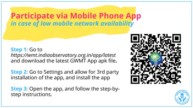
To learn about how to install and use the app, please watch the GWMT Tutorial, at the link https://youtu.be/_w4udL0BGF8
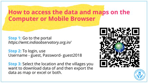
Please get access to all groundwater monitoring resources in this link, including photos and videos


